Showing 573 items
matching old maps
-
 University of Melbourne, Burnley Campus Archives
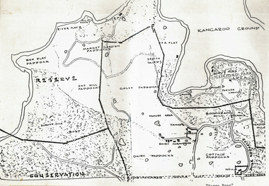
Plan - Coloured plan, Plan of Burnley Gardens, 1929?
Layout of gardens, farm buildings, orchard, etc. overlaid on part of Lands Department map. See paper catalogue for full descriptionPart of larger plan (Lands Department Parish Plan). Partly hand-drawn. Area bounded by Yarra River, Swan St, Glen Iris railway line. Shows Burnley Gardens layout, handwritten amendments and explanation of existing and proposed structures including: Pavilion, sketch of unbuilt Administrative Building, poultry yard, contours of old orchard, sketch for Plant Research Institute, ditch, silo, milking shed, laying pens. See aboveburnley gardens, pavilion, burnley school of horticulture, farm buildings, poultry -
University of Melbourne, Burnley Campus Archives
Book, Orchard, 1955-1959
No. 01310H Norman Bros. Pty. Ltd. 60-62 Elizabeth St., Melbourneorchard, field station, history, fruit tree blocks, planting plans, newspaper cutting, red delicious apple, preston prolific fig -
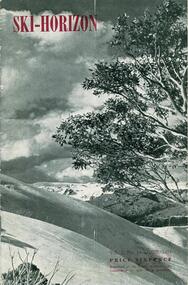 Falls Creek Historical Society
Journal - Ski-Horizon Vol. 2 No 10, June 1951
Ski-Horizon is the official journal of the Federation of Victorian Ski Clubs which began publication in 1949. The were 26 original member clubs which included Albury Ski Club, Bogong Ski Club, Myrtleford Ski Club, Tallangatta and District Ski Club and Wangaratta Ski Club. Two pioneers of Falls Creek, Tom Mitchell, M.L.A., and Martin Romuld were Vice-Presidents of the Federation.This Journal is significant because it documents the early development of skiing in Victoria.The journal features stories and events chronicling developments in Victoria and internationally. Items related to the Falls Creek Area in this publication include:- Page 2: Albury Ski Club is set for a positive year. Present membership of the club is 130 and officials. recently elected are: -President, Mr. Fred Griffith; Vice-President and Booking Officer, Bob Howe; Secretary. Nell Newton; Asst. Sec., Angela Bowler; Treasurer. Sam Roxburgh; Social, Bruce Colquhoun: Trips, June Watson; Bus, Len Egan; Building. John Perger; Equipment, Peter Hadow. Page 3 Toni St. Elmo is planning the monster party the Bogong Ski Club will give at their Falls Creek Lodge on 4th August to the visiting N.Z. team. Page 8 - 9 Article - The Old Order Passes on the Bogong High Plains - an extensive response to the State Development Committee's Report "The Alpine Regions of Victoria; Skiing and Tourist Resorts" and suggestions for the construction of roads, ski tows and other facilities. A sketch map of Falls Creek Village is included.ski history victoria, federation of victorian ski clubs, development of falls creek -
 Mrs Aeneas Gunn Memorial Library
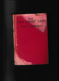
Book, Heinemann, The old front line, 1917
... Ill, maps, p.128. The old front line Book Heinemann John ...An account of the beginning of the battles of the SommeIll, maps, p.128.non-fictionAn account of the beginning of the battles of the Sommeworld war 1914-1918 - campaigns - france, world war 1914-1918 - battle of the somme -
 Wonga Park Community Cottage History Group
Plan (sub-item) - Black and White, Map of “Yarra Brae”, site of Scout Jamboree and World Rover Moot, Not known, possibly 1985
-
 Mont De Lancey
Book, Oxford University Press, 1. The Holy Bible, containing the Old and New Testaments 2. Daily Light on the Daily Path, Unknown
1. A Holy Bible containing the Old and New Testaments. At the back there is an Indexed Atlas to the Holy Bible with a List of maps and a List of Biblical Names. This is followed by twelve yellow and blue coloured maps of the Lands and Nations of the Bible. 2.A miniature book titled Daily Light on the Daily Path, A Devotional text book for everyday in the year..1. A black leatherette softcover Holy Bible contains the Old and New Testaments with the title and publisher Oxford printed in gold lettering on the spine. There are five embossed double lines on the spine too. On the front cover at the bottom right there is printed in gold lettering J.H.L. At the back there is an Indexed Atlas to the Holy Bible with a List of maps and a List of Biblical Names. This is followed by twelve yellow and blue coloured maps of the Lands and Nations of the Bible. The pages have gilt edges. 348p. Inside the front right hand side endpaper written in small blue handwriting is a prayer as written in the Inscription box below. 2. A miniature brown leatherette softcover book titled Daily light on the Daily Path - a devotional text book for every day of the year. The faded title is printed on the front cover at the top and on the spine. At the back there is a section For Special Occasions: Easter, Affliction, Marriage, Bereavement and others. There are two lists of the Daily Texts - the morning and evening hour arranged in biblical order. The edges of the pages are gilt. In the front is handwriiten in black ink - Neville Lordnon-fiction1. A Holy Bible containing the Old and New Testaments. At the back there is an Indexed Atlas to the Holy Bible with a List of maps and a List of Biblical Names. This is followed by twelve yellow and blue coloured maps of the Lands and Nations of the Bible. 2.A miniature book titled Daily Light on the Daily Path, A Devotional text book for everyday in the year..religious books, bibles, prayers -
 Mont De Lancey
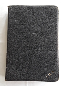
Book - The Holy Bible - The Revised Version, Oxford University Press, 1949
A Holy Bible containing the Old and New Testaments with six coloured biblical maps at the back.A black hardcover Holy Bible, Revised Version, Oxford printed in gold lettering on the spine with five raised black lines across. The pages have worn gilt edges and there is a self bookmark included. 286p. It contains the Old and New Testament. At the back there are six coloured maps of the biblical locations. The title page has a glued in black and white photograph of Mr and Mrs J.H. Lord standing a garden. There is a small card attached with photo hinges with the inscription below. Mr and Mrs J.H. Lord is written by hand in black ink below the photograph. The back cover is mended with a wide strip of white cotton material.non-fictionA Holy Bible containing the Old and New Testaments with six coloured biblical maps at the back.religious books, bibles -
 Wonga Park Community Cottage History Group
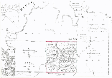
Photograph (sub-item) - Map of original land settlement in 1890’s – known as ‘the Eight Hour Pioneer village Settlememt’, the square mile around the Wonga Park Store today (red square)
Map of original land settlement in 1890’s – known as ‘the Eight Hour Pioneer village Settlememt’, the square mile around the Wonga Park Store today (red square). -
 Wodonga & District Historical Society Inc
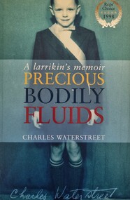
Book - Precious Bodily Fluids: A Larrikan's Memoir, Charles Waterstreet, 1998
This publication tells the story of the battle to introduce fluoridation to eh water supply of Albury in New South Wales. The events are described through the eyes of the author, Charles Wallstreet wo was a11 years old when the battle raged.A publication of 262 pages. Soft cover includes images with the synopsis published on the back. The inside cover includes a map of the Albury district .non-fictionThis publication tells the story of the battle to introduce fluoridation to eh water supply of Albury in New South Wales. The events are described through the eyes of the author, Charles Wallstreet wo was a11 years old when the battle raged. albury nsw social conditions, albury 1960s -
 St Patrick's Old Collegians Association (SPOCA)
Photograph - Teachers, Jesuits
-
 St Patrick's Old Collegians Association (SPOCA)
Photograph - Teachers, Jesuits
-
 St Patrick's Old Collegians Association (SPOCA)
Photograph - Buildings, SICG, Loans 3
-
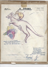 Melbourne Legacy
Drawing, A Toast
A drawing done by artist Pat Hanna and sent to friends at Legacy. He was living in London at the time and drew this on his letterhead. It was stored with other items including a letter to Frank in 1972 (possibly L/- Frank Doolan who was making an attempt to collect items relevant to Legacy's history for an official archive project - see items 01400 to 01403). Pat Hanna was an entertainer, comedian, artist and producer of reveues, plays and movies. One of his first revues was performed in France just after the armistice. A popular stage show was 'Diggers' that performed around Australia post-war and adapted to film in 1931. He was asked to pose for photographer Jack Cato for the iconic image of a digger shown in 01400. He was born George Patrick Hanna, 18 March 1888 in Whitianga, New Zealand and served in the First World War, was a founding member of Melbourne Legacy and was involved with Legacy for many years. Pat Hanna was a founding member of Melbourne Legacy and an artist and producer. Legacy kept some of his works in the archive.Drawing of a kangaroo and kiwi from Pat Hanna on his letterhead pasted onto brown cardboard. Also a digger's face, a rising run and maps of Australia and New Zealand.Handwritten in the drawing 'Heres to every cobber who wore the old chapeau, 20 - 30 - 40 - 50 years ago!!!' and 'There's a wee toon on the Yarra with streets broad and narra that's where we first toasted dear old Legacy.'hanna, founding legatee -
 Bacchus Marsh & District Historical Society
Map, Lerderderg Park Lands sale plan. 1911
This plan was for the sale of parcels of land from the Lerderderg Park Estate property in 1911. Advertising for the sale appeared in the Bacchus Marsh Express newspaper through July of 1911. The property was situated only a few kilometers from the township of Bacchus Marsh. The agents for the sale were L. A. Fairbairn & Co.Lerderderg Park Estate was a significant and early colonial property in the Bacchus Marsh area. This plan provides details about the first time the property was subdivided for sale. It is therefore documents an important moment in the history of this property and the broader trend of the subdivision of older and larger properties in the district.A single page paper plan showing allotments of land for sale from the Lerderderg Park property owned by John Wills. The parcels of land for sale are coloured in red.The Lerderderg River and Pyke's Creek Irigation Channel shown on the plan are in blue ink. The rest of the plan is a dark cream or beige colur with the text in black ink. The plan has been extensively annotated with hand-written notes indicating the names of people who purchased the various parcels of lands and the prices paid for those lands. Part of the top of the plan containing some text appears to be missing. The plan is pasted into a bound volume containing 76 maps or plans in total. Top: Have received instructions to Sell, account Mr John Wills, his renowned LERDERDERG PARK LANDS, so well and favourably known throughout the Commonwealth. In areas from 3 acres to 1276 acres. Every lot is either rich lucerne land (or portion now under lucerne) with some higher land adjoining Railway Station, and 2 Milk factories within 2 miles, absolutely the finest land in Victoria. Bottom: THIS IS THE FIRST SUBDIVISIONAL SALE of Rich Flats in Bacchus Marsh since the Pyke's Creek Scheme, and every lot is commanded by it. Only 32 miles from Melbourne.bacchus marsh victoria maps, land sales, lerderderg park estate, land subdivision -
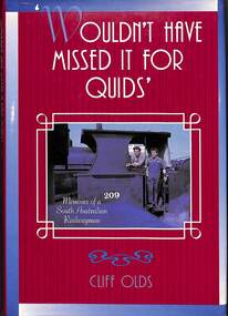 Victorian Railway History Library
Book, Olds, Cliff, Wouldn't Have Missed It for Quids: Memoirs of a South Australian Railwayman, 1996
Illustrated memoirs of Cliff Olds a South Australian railwayman.ill, maps, p.119.non-fictionIllustrated memoirs of Cliff Olds a South Australian railwayman.railroad operations - south australia - history, locomotives - south australia - history -
 Federation University Historical Collection
Map, Ballarat Goldfield, c1898
This map shows geological features, suggests the last basalt flow, and includes alotments and names of Mining Companies. Although this map has no date on it the Ballarat Industrial School is used for dating purposed. The Ballarat Industrial School ran from 1869-1879, but the term Ballarat Industrial School Reserve was still in use in 1898 and possibly beyond.Geological Map of Ballarat with 3 holes in the left hand side. The map indicates the position of Lake Wendouree, Township of Warrenheip, Ballarat East, Industrial School Reserve, Winters Swamp, Police Paddock, Wyndholm Premptive Right (Salton and Waldie), Black Hill, Vale Park Reserve, Pennyweight Hill, Little Bendigo, Black Swamp Lead, monte Christo Reef, Chinaman's Gully, Miners Rest, Pincotts Dam, Northumberland Gully. It also show the following goldmining companies: City of Ballarat, Kohinor, Hand and Band, Great North West, Northern Junction, Kneeshaw, Rossers Freehold, Silurial.ballarat, warrenheip, lake wendouree, ballarat east, winters swamp, winter swamp, wyndholm premptive right, cemetery, vale park reserve, little bendigo, kneeshaw co., industrial school reserve, kirks dam, pincotts dam, black hill, wombat hill, dead horse gully, miners rest, mt rowan, salton and waldie, rose hill co, great north west no 1, rose's freehold co, hand and band co, police reserve, police paddock, mount rowan, ballarat industrial school reserve, market reserve, winter's swamp, kneeshar co, monte cristo line of reef, chinaman's gully or black snake, milkmaid's gully, ballarat gold field, bakery hil lead, old gravel pits lead, golden point lead, eureka lead, miner's rest, yarrowee creek, leigh creek, black swamp lead, yorkshire reef, nil desperandum reef, cockatoo lead, hit or miss gully, herbert werner frederick de nully, pennyweight hill, esmond's lead, ash's lead, nightingale lead, john bull gully, gladstone reef, whitehorse reef, petticoat creek, pincott's dam, frenchman's gully, tim's crushing plant, jenkin's gully, california gully, drake's creek, sulton and waldie, ballarat undustrial school, ballarat & mariborough railway -
 Federation University Historical Collection
Map - Geological Survey, J. Phillips, Geological Survey of Victoria - Ballarat, 1857, 10/1858
Geological map of the Ballarat District featuring four colours.ballarat, geological, geology, geological plan, main road, camp, golden point, pennyweight hill, clayton hill, ballaarat cemetery, bakery hill, specimen hill, soldiers hill, nightingale lead, native youth black hill flat, white flat, mining, mines, eureka lead, old post office hill -
 Victorian Railway History Library
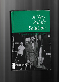
Book, Melbourne University Press, A very public solution : transport in the dispersed city, 2000
In A Very Public Solution, Paul Mees compares Melbourne's public transport system with the highly successful system in Toronto - a 'dispersed' city very like Melbourne with its suburban sprawl - and sheds new light on a century-old debate." "A Very Public Solution is for everyone concerned with urban sustainability and our growing traffic problems.Index, bib, maps, p.331.non-fictionIn A Very Public Solution, Paul Mees compares Melbourne's public transport system with the highly successful system in Toronto - a 'dispersed' city very like Melbourne with its suburban sprawl - and sheds new light on a century-old debate." "A Very Public Solution is for everyone concerned with urban sustainability and our growing traffic problems.urban transportation - melbourne, local transit - melbourne, local transit - ontario -
 Buninyong Visitor Information Centre
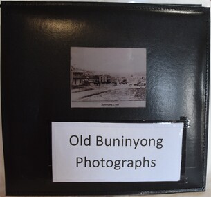
Album - Photograph Album, Old Buninyong Photographs (Early Buninyong)
The album was compiled by Derek Leather using photographic reproductions of images of Buninyong. The album includes early maps, streetscapes, monuments and buildings.Significant images of nineteenth century Buninyong streetscapes.Black, hard-covered album with thirty-two fixed photographs and five lose photographs. Compiled by Derek Leather, former Shire of Buninyong councillor. Old Buninyong Photographsbuninyong, derek leather, streetscapes -
 Warrnambool and District Historical Society Inc.
Book - Family Bible, John Murphy Company, The Holy Bible Douay Version, 1899
This Bible and cover belonged to Ethel Ardlie, nee Ryan (1880-1967). In 1903 she married Arthur Stanley Ardlie of Warrnambool. Arthur Ardlie was the son of the prominent Warrnambool lawyer, William Ardlie and his wife Mary and the grandson of John and Mary Ardlie, pioneer settlers in Warrnambool. Ethel and Arthur Ardlie had three daughters, Olive (1905- 1912), Dorothy (1910-1993) and Agnes (1915-1993). They lived at Aroona, Princess Street, Warrnambool.These items are of great interest firstly because they are examples of the type of Bible and cover that families owned in the mid 20th century. Also they are mementoes of a prominent family in Warrnambool in the 20th century, with the Bible containing important information on this family. .1 This is a Bible with a black cover with gold lettering on the spine. The cover is stained. The pages contain the Old Testament (1086 pages), a Family Register section, the New Testament (306 pages) and some coloured maps. Amongst the pages are two pressed pansies and two loose sheets. .2 This is a brown tooled leather cover for the Bible with a brown silk lining and a brown cord attached to the top of the spine for use as a bookmark. The front cover has an embossed image of seven figures. The edges of the spine of the cover are torn. Ethel M. Ardlie (x2) Aroona, Warrnambool ardlie family, history of warrnambool -
 Mont De Lancey
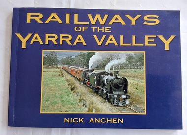
Book, Nick Anchen, Railways of the Yarra Valley, 2010
The railway reached Lilydale in 1882, Healesville in 1889 and Warburton in 1901 linking the area to Melbourne. Sawmillers and farmers prospered, as well as tourists visiting the region.A blue covered book of the Railways of the Yarra Valley with a photograph on the front cover of the last steam train from Warburton in August 1965 and the back cover showing an old locomotive 'Little Yarra' in 1913. There is historical text and maps with black and white and coloured photographs of the railways and of the area.Pp.96.non-fictionThe railway reached Lilydale in 1882, Healesville in 1889 and Warburton in 1901 linking the area to Melbourne. Sawmillers and farmers prospered, as well as tourists visiting the region. trains, rail vehicles, australian history, yarra valley -
 Federation University Historical Collection
Map, Ballaarat Gold Field, 1861, 1861
A party of surveyors camped by Yuille's Swamp (later Lake Wendouree) and surveyed the countryside for a map to be produced by the Geological Survey of Victoria. In November 2004 the Central Highlands Regional Library presented a special edition of 200 copies of the 1861 map reproduced from a copy in their collection. Original 1861 map of Ballarat showing streets and leads. Blue dots indicate gold leads, and red lines indicate auriferous quartz reef and outcrops of quartz veins."Compiled & Drawn from the Survey of Mining Surveyors Davidson, Fitzpatrick and Cowan & the Plans in the Surveyor General's Office by J. Brahe, 21st October 1861. R. Brough Smyth, Secretary for Mines. The Honourable J.B. Humffray, M.L.A. Commr of Mines.”ballarat, map, ballarat east, lake wendouree, survey, mines, robert davidson, ballarat gold field 1861, yuille's swamp, wendouree swamp, little bendigo diggings, gold leads, old post office hill, specimen hill, bakery hill, black hill, dead horse creek, brown hill, pennyweight hill, clayton hill, soldiers hill, golden point, gum tree flat, white flat, poverty hill, chinese village, robert brough smyth, ballarat map 1861, ballaarat vineyard, dead horse gully, deadhorse creek, invermay, black hill flat, gaelic church, police reserve, magpie range, dalton's flat, caadian lead, rifle butts, powder magazine, bathing house, government camp, gold office, chinese, llanberrris, victoria theatre, charlie napier hotel, united states hotel, grape's hoel, clayton's hill, cattleyard hill, free trade hotel, esmond lead, bakery hill, black hill lead, juvenile reformatory, ballarat orphanage, lady barkly lead, triffet's slaughter yard, little bendigo, melbourne road, t. cowan, thomas cowan -
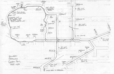 Ballarat Tramway Museum
Document - Photocopy, Dave Macartney, Drawing of ESCo Ballarat Tramways, c1990
Photocopy of a drawing prepared by Dave Macartney in the mid 1980's of the track layout of the Electric Supply Co. of Victoria's Ballarat Tramway system, excluding the single track to Sebastopol. Plan shows the location of the loops, loop type, street names, position of replacement loops installed by the SEC during the reconstruction, depot layout, powerhouse siding and railway in Lydiard St. North. Prepared from inspecting the Plans of Ballarat services drawings in the Ballarat Water Board's Offices. Drawn on the back of old import forms of a light weight paper and has shown through the printing underneath. Titled "Ballarat Tramways Company Days 1905 - 1930" Number of small differences to the map drawn for Keith Kings, "The Ballarat Tramways" book, page 22.trams, tramways, ballarat, esco, track layout, map -
Bendigo Historical Society Inc.
Map - BELLE VUE NO 2 - PLAN OF LEASES
BHS CollectionPlan of Mining Leases from Rowan Street to Long Gully. Reference J. N. Macartney 2nd Edition Bendigo Goldfields Registry for 1872. Names of Leases are: Moore ?, Ellesmere Co, Bonati & Co, Dennis, Abe Lincoln Co, Lansell & Hunt, Black & White Lead Co, Koch & Hildebrand, Ballerstedt, Lazarus Co No 1, Lazarus Co, Watson, Lazarus Freehold, Lazarus Co No 2, Lazarus Tribute, South Extended Burra, Endeavor Co, Old Chum Co, Burrows and Sterry, New Chum & Victoria Trib, Jackson, North Old Wybrants Chum Co, Myra Co, McLenn, Geary & Co, Western Victoria Hill G. M. Co, Victoria Reef G.M.Co, South Adventure Co, South Try Me Well, W. Rae, Wells Midway, Extended Co, Handy Andy, Moonta Co, Humboldt Co, Adventure Co, Try Me Well, Sterry & Co, Midway, Tudor, Friedman's Reef, Rising Sun, Try Me Luck,Pomponia, Confidence Co, Alfred Co, Advance Co, Prince Alfred Co, Canterbury Co, Platus Co, S. Platus Co, Golden Fleece United, Alfred Co, Iron Duke Co, Victoria Gold Mines Co, Hercules Co and Iron Bark.map, bendigo, mining plan, belle vue no 2, no 2 belle vue new chum & c, j n macartney bendigo goldfields registry 1872, moore ?, ellesmere co, bonati & co, dennis, abe lincoln co, lansell & hunt, black & white lead co, koch & hildebrand, ballerstedt, lazarus co no 1, lazarus co, watson, lazarus freehold, lazarus co no 2, lazarus tribute, south extended burra, endeavor co, old chum co, burrows and sterry, new chum & victoria trib, jackson, north old wybrants chum co, myra co, mclenn, geary & co, western victoria hill g. m. co, victoria reef g.m.co, south adventure co, south try me well, w. rae, wells midway, extended co, handy andy, moonta co, humboldt co, adventure co, try me well, sterry & co, midway, tudor, friedman's reef, rising sun, try me luck, pomponia, confidence co, alfred co, advance co, prince alfred co, canterbury co, platus co, s. platus co, golden fleece united, alfred co, iron duke co, victoria gold mines co, hercules co, iron bark -
 Bendigo Historical Society Inc.
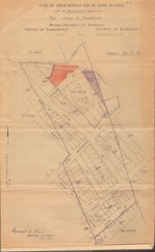
Map - MCCOLL, RANKIN AND STANISTREET COLLECTION: MAP LEASE NO 10423
Buff coloured map. On top of map 'plan of area applied for on lease no. 10423, under the mining leases regulations, by John G. Stanfield, mining district of Bendigo. Map shows lease coloured in red, see record 2205.821b for letter pertaining to map. Street on map: Rowan St., Shamrock St., Mackenzie Street, Old High St., High Street, Ophir Street, Booth Street.bendigo, business, mccoll, rankin & stanistreet -
 Melbourne Tram Museum
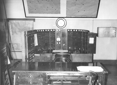
Photograph - Black & White Photograph/s, Melbourne & Metropolitan Tramways Board (MMTB), late 1964
Black and white photographs of the Electrical Control room supervisory panel, that was located in Bouverie St and Queensberry St Carlton known as Carlton Control. Photograph most likely taken at the same time as the new panel was implemented - see Reg item 4514 - late 1964. Shows the panel and its set up, maps on the wall and other equipment and a table in front of the operators table or position. The MMTB News - 1721.4 - Vol. 1, No. 4 - 20 pages, November - December 1964, with a colour photo of the new Supervisory control room at Carlton on the front cover. Has articles on; chairman's message, tramway band, Carlton Control - Supervisory Centre, safe electrical working, Christmas celebrations, the old power control centre, a obituary for H. H. Bell, Remembrance day. Printed on gloss white paper.trams, tramways, carlton, substation, electrical equipment, electrical switching, carlton control -
 Melbourne Tram Museum
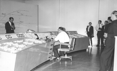
Photograph - Set of 5 Black & White Photograph/s, Melbourne & Metropolitan Tramways Board (MMTB), late 1964
Series of five black and white photographs of the Electrical Control room supervisory panel, that was located in Bouverie St and Queensberry St Carlton known as Carlton Control at the time of the implementation late 1964 .1 - General view with the Press standing around. .2 - View of the operators control desk .3 - ditto with the operator at "work" .4 - The room and map without the chair etc. .5 - ditto but a side view. The MMTB News - 1721.4 - Vol. 1, No. 4 - 20 pages, November - December 1964, with a colour photo of the new Supervisory control room at Carlton on the front cover. Has articles on; chairman's message, tramway band, Carlton Control - Supervisory Centre, safe electrical working, Christmas celebrations, the old power control centre, a obituary for H. H. Bell, Remembrance day. Printed on gloss white paper.Items .4 and .5 are stamped on the rear.trams, tramways, carlton, substation, electrical equipment, electrical switching, carlton control -
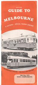 Melbourne Tram Museum
Pamphlet, J B Publications, "Visitors Guide to Melbourne", May. 1974
Pamphlet - 28 pages, centre stapled titled "Visitors Guide to Melbourne", dated 20 May 1974. Has on front cover trams W7 1032 and PCC 1041 with the caption "Melbourne's Trams - the old and the new" Has many advertisements, a small map, places of interest including Sovereign Hill, Leonda, driving in central Melbourne and wearing of seat belts. Has photo looking north along Swanston St - see image 2. Welcome by Minister for Tourism Murray Byrne.trams, tramways, melbourne, visitors, guides, w7 class, 1041, tram 1032, tram 1041 -
 Melbourne Tram Museum
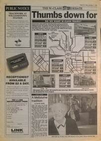
Newspaper, Herald Sun, "Thumbs down for old trams", 12/11/1993
Gives the result of a Herald Sun survey with a map - People were asked: 1 - Want to keep the W class trams 2 - Want W class for Tourism 3 - Want W class withdrawn Survey involved the Airport West, North Coburg, Mont Albert, South East (route 8 and 69, and city streets. The choice included retiring the early Z class trams, that were not even 20 years old. Includes an interview with Jean Geil by David Jarvis on the trams and with Lisa Fabian who did not like the W. Item written by Damon Johnston, Transport Reporter.Demonstrates The Herald Sun investigation into W class trams during 1993.Newspaper clipping from The Herald Sun, Friday 12/11/1993, titled partly ""Thumbs down for old trams" spread over two pages.trams, tramways, w class, surveys, public transport, state transport authority, ptc -
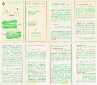 Melbourne Tram Museum
Pamphlet, Melbourne & Metropolitan Tramways Board (MMTB), "Short Trips around Melbourne and Suburbs by Bus and Tram", mid 1960's
Pamphlet titled "Short Trips around Melbourne and Suburbs by Bus and Tram", two colour printed document folded into 8 on buff coloured paper, featuring 14 various trips around Melbourne, with a detailed description of each route, time, fare and notes. On reverse side is a detailed map of the MMTB tram and bus routes - from map date document mid to late 1960's - old route numbers eg 4D and Point Ormond and Footscray have closed. See also Reg Item 1508 for an earlier version.trams, tramways, mmtb, map, tourist trips, fares, routes