Showing 9121 items
matching photo’s
-
 Bendigo Military Museum
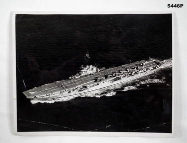
Photograph - PHOTOGRAPH, HMAS MELBOURNE
Photo of the HMAS Melbourne at sea in reference to James Leslie Pell RAN No 35213 Stoker mechanic who served on the ship in the mid 1950’s. Previously had served in Korea 1951-1952 on HMAS Bathan Black and white photograph of HMAS Melbourne. RAN stamp on the back and some black inkStamp on the back “Royal Australian Navy” Copyright reserved. Not to be communicated to te press without Naval Board approval hmas melbourne, royal australian navy -
 Bendigo Military Museum
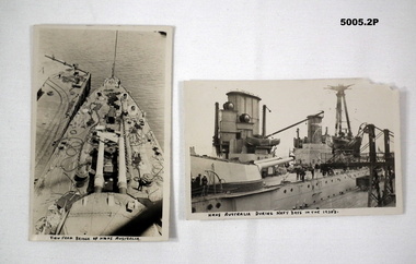
Postcard - POSTCARDS OF HMAS AUSTRALIA IN 1920, Royal Australian Navy, c1920's
1. B & W postcard shows scene of foredeck taken from the bridge. One twin gun turret can be observed. The ship is tied up at a wharf. 2. Side view of HMAS AUSTRALIA. The photo shows one gun turret, two funnels and wireless mast.1. On front bottom is handwritten "View from bridge of HMAS AUSTRALIA". 2. On front bottom is written "HMAS AUSTRALIA during Navy days in the 1920's" .photographs, ran, hmas australia -
 Bendigo Military Museum
Photograph - PHOTOGRAPH 38th BN, C . 20.6.1916
... , Cyril S McPherson” Photo B & W showing a ship in harbour pasted ...These 5 soldiers enlisted in the 38th BN at various times pre embarkation and were all Sgt’s at embarkation on 20.6.1916, all embarked for France on 22.11.1916. Cyril Sutherland McPherson No 938 age 23 years C Coy, promotions CSM then 2nd Lieutenant, WIA 22.10.1917 GSW Chest & Leg severe, appointed in AIF terminated 5.4.1918 medically unfit. Garrett Ernest Fitzgerald No 874 C Coy age 22 years, WIA 30.1.1917 Concussion Slight, appointed 2nd Lieutenant, WIA 29.5.1917 GSW right arm & right leg severe, rejoin unit, appointment terminated 23.12.1918. Thomas Herbert Blair No 815 C Coy age 18 years, promotions CSM then 2nd Lieutenant, WIA 28.5.1917 GSW right Buttock, DOW’s 28.5.1917. Glanfield Keith Emonson No 543 B Coy age 21 years, appointed 2nd Lieutenant, WIA 9.12.1916 GSW Head and Right Thorax severe, awarded “MC” 8/9th. 12.1916, appointment terminated 22.6.1917. Aubrey Rupert Edwards Wilson No 670 B Coy age 23 years, gets into trouble and reduced to Pte, transfers to 39th BN 15.3.1917, he is WIA later on. Photo B & W showing a ship in harbour pasted onto a cream coloured cardboard background, a slight raised area around the photo, 6 names have been written on the card board.“K.G.Emonson Sgt, T.H.Blair, A.R.E.Wilson Sgt, G.E.Fitzgerald Sgt, Cyril S McPherson” photographs, 38th bn, c coy, b coy, runic -
 Bendigo Military Museum
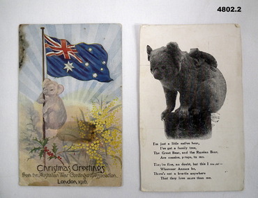
Postcard - CHRISTMAS GREETING POSTCARDS, KOALA MOTIF, Australian War Contingent Assoc, 1916
1. On the rear the letter is written in ink. It's addressed as "Dear Susie.../from your loving brother Joe" Undated buts it's hot in Australia. 2.1, Colour printed postcard. It shows a Koala up a flag pole. Australian flag on top. There are sprigs of wattle and holly. At bottom is stamped "From the Australian War contingent Association. London 1916. 2. Black and white photo of Koala and cub. A poem i sprinted at the bottom on the rear, written in ink is a short message to Dear Susie ..........From Your Loving Bro, Joe. (He states he is "still alive and well! Addressed to Miss S Stuart, Serpentine Via Inglewood, Vicpostcards, ww1, family -
 Bendigo Military Museum
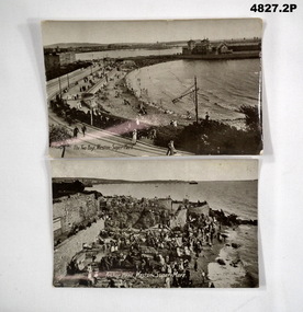
Postcard - POSTCARDS, SCENIC, F. Keeping of Weston Super Mare et al, 1. 1917. 2. 1917
See Cat 4799 for data.1. Photo of a harbour. Tramway and people strolling along beach. 2. Poto of a harbour, bit of an old castle, a jetty in the background. Titled Änchor Head, Weston Super Mare. A lot of people present on the beach.1. Addressed to Miss Stuart, Serpentine via Inglewood, Vic 6 lines of text to "Dear Susie ...............8 lines of text starting with "On the way home now". 2. Addressed to Miss S. Stuart, Serpentine via Inglewood,.ww1, weston super mare -
 Bendigo Military Museum
Postcard - POSTCARD, PHOTOGRAPHIC, WW1, League of Soldiers Friends, Victoria
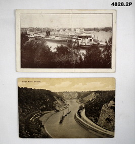
1. This card was printed by the "League of soldiers friends - C of E Organisation in Victoria. To help the A.I.F." It has been stamped by the AIF camp PO 19 April 19. 2. Nothing specific.1. Black and white view of ships in a harbour. In the foreground are some tree tops. A big city is in the background. This card has a pre-printed message from Southhampton. 2, Boats in a river/canal. Black and white photo. The water way is in a deep valley.1. Addressed to Miss S. Stuart, Serpentine via Inglewood, Vic, Australia. It is signed by J. Stuart. 18 April 1919. 2. Addressed to Dear Susie, 10 lines text - signed your loving brother Joe.postcards, ww1 -
 Bendigo Military Museum
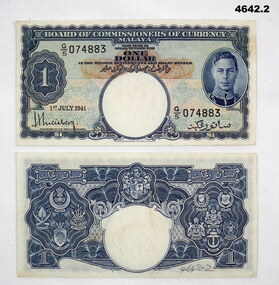
Currency - CURRENCY, MALAYAN, Malay States, Both 1st July 1941
Items souvenired by Alan Mason, refer cat No 3979.2.1).2) Currency Malayan, “One Dollar”, rectangular shape, blue, white and light brown colours, photo inset of the King on right hand side, note s dated..1) “G (over) 5 074883” .2) “G (over 5) 074884”currency, malayan, one dollar -
 Lara RSL Sub Branch
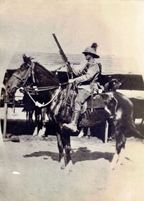
Service Gear, Trooper Patrick Nolan, Picture on his horse "Jack Ordeal" with his googles, stirrups, Registration of membership to R. S..S. I. L .A. dated 6/2/1917, badge "Rising Sun"
Details relating to Trooper Patrick NolanWW1 8th Light HorsePhotograph of Trooper Patrick Nolan on his horse "Jack Ordeal" taken at Port Said. Accompanied by items: stirrups, badge "Raising Sun, Registration of membership to R. S..S. I. L .A. dated 6/2/1917. Patrick Nolan Joined as a labourer aged 21 on 5/8/1915. Attached to Reinforcements, the 8th Australian Light Horse. Also known as Maygar's Boys. Suffering shell shock and deafness at Bir El Abd, Sinai, 8/9/1916. Discharged in Melbourne, 8/12/1916, rejoined Home Service 6/2/1917. Discharged at own request 21/6/1917. Rejoined 26/7/1917. Discharged 5/5/1918Dust/sand goggles, leather with brown lens for desert warfare. Lens 4.5 cm round, Badge "Rising Sun" Australian Military ArmedForces L 6.00 cm H. 4.5 cm. 1904 blackened copper. Left and Right strips. Markings stamped inside C. Greatnfk & Son Ld, solid nickel. The righthand strip has a broken foot strap mounting. Paper receipt for membership to Returned Sailors & Soldiers Imperial League dated 6/2/1917. Number 965. Group Photo * light bHorse Inscription on Back - mBack Row @nd from Left Patrick Nolan Dad 8th Light Horse Egypt 1st World War 1914/1918 nolan patrick 8th light horse world war one trooper stirrups goggles rising sun -
 Lara RSL Sub Branch
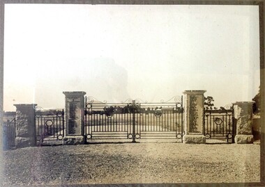
Lara Memorial Gate Photo 1928, Lara Recreation Reserve Memorial Gate Photo 1928, 1928
Following World War One, the present Memorial Gates at the front of the Lara Recreation Reserve (opposite the service station), were erected and the names of 104 men and woman who enlisted from Lara Districts were added. Twenty four paid the supreme sacrifice. They were erected at a cost of £380 by Barklamb Brothers of Caulfield. His Excellency The Governor Lord Somers officially opened the gates on 22 December 1929. RSM Cadwell was in charge of the program. The ceremony involved a large gathering where Lord. Names on Gates of WW1 Veterans Listed below - Following World War One, the present Memorial Gates at the front of the Lara Recreation Reserve (opposite the service station), were erected and the names of 104 men and woman who enlisted from Lara and districts were added. Twenty Four paid the supreme sacrifice. His Excellency The Governor Lord Somers officially opened the gates. RSM Cadwell was in charge of the programme. Sommers inspected a guard of honour from the 23rd Battalion (City of Geelong Regiment). In addition to a parade of returned soldiers, music was provided by the Geelong City Band. Names on Gates of WW1 Veterans Listed below - Andserson W.A. Fry J.F. Mullins M. Bates J. * Gabrielson E. * McDonald H. Bates G. Gardiner H.A. McDonald G. Beggs J.S. Gibbons H. * McHarry E.J. Bennett E.J. (3755) Gibbons W. McEwan G. Beardsell T. Gibbons G. McIntyre J.L. (3421) Branch W.J. (3029) Grass E.J. (687) McIntyre J.W. (7049) Callaghan C. Grass C.H. McIntosh J. Carter W.J. Groves H. McKellar G. Cashmore J.A. Harris W. McLeod R. Cashmore F.J. Heal H. P. (1134) Nicholls J. Cashmore A.G. Heal F.W. (1135) Olive C.A. * Cashmore A.J. Heal E.L. (1133) Oliver D.H. Chirnside J.L. Heyward F.C. * Owens S.J. Clayton J.H. * Heyward W. O'Neill J. Connop J. * Hill E.J. * Parsons M. Connop E. * Howard H.L. (4138) Parker S. Collins F.H. * Inglis H. Perkins C.E. Collins R.B. * Izon C.E. Shannahan J. Collins H. James R. Spitty C. Collins A. Jenkins W. Steele J. Coogan M.T. * Jenkins H. Tayler R. Curle O. Kee H.K. Tayler W.H. (794) Duggan H.J. * Keneally J. Teesdale V.B. (5241) Duggan R. Kent G.G. Thomas D.H. Duggan T.M. Kortright J. Tregilas S. * Dunn W. Lodge J.A. * Trim A. Dodesmaide F. * Lodge G.L. * Tipping S. * Edols R.W. Lodge T.S. * Turnbull J.W. * Farrelly P. Miller P. * Walker H.D. Farrer R. * Minogue P. Watt W. Firth D.H. * Moodie E. Wembridge W.P. * Firth A.C. Morgan C.E. Sister McNaughton K. Foot M.T. Moroney L.F. (4088) Sister McIntosh S. Foot C.H. * The Supreme Sacrifice Sommers inspected a guard of honour from the 23rd Battalion (City of Geelong Regiment). In addition to a parade of returned soldiers, music was provided by the Geelong City Band. The Memorial Gates are of local heritage significance and are included as Heritage Overlays in the Greater Geelong Planning Scheme,unveiled by the govenor Lord Somers on the 22 dec 1929. Read comments on bottom of photoComprising four square granite piers with central vehicular and flanking pedestrian metal gates.The gates commemorate the names of the 104 men and women of the Lara region who served in World War One.lara, memorial gate, ww1, world war 1, lara recreation reserve, lord somers, rsm cadwell, 1928, monument, 23rd battalion, city of geelong regiment, geelong city band -
 Lara RSL Sub Branch
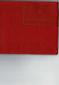
Postcards Booklet, Souvenir of Aberdeen - series of postcards, United Kingdom
... of Aberdeen scenes in Black & White. 15 Black & White photo's circ ...15 Photograph's of Aberdeen scenes in Black & White.15 Black & White photo's circ. early 1920'sSouvenir of Aberdeen - series of postcardsSouvenir of Aberdeen, Red covered cardboard coveraberdeen, u.k. -
 Shepparton RSL Sub Branch
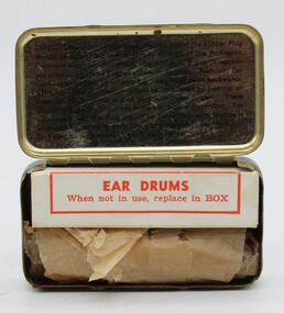
Protectors ear drum, ear protectors
standard for all services in the 1950's and 1960's mass produced moulded tin.ear protection as issued to all personalKhaki painted tin, hinged lid written instructions in lid, diagrammatic instructions in base in black lettering.Protectors ear drum (aust.) MK1 M Large on outside of lid. For inscription of internal markings refer to photo's of inside of tin.ear plugs, ear protectors -
 Bendigo Military Museum
Postcard - PHOTO POSTCARDS, c.1914 - 19
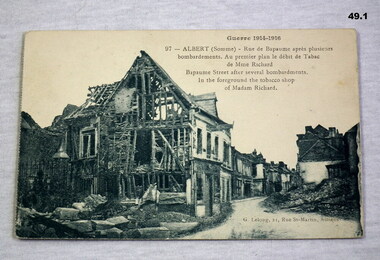
.1) War damage Albert .2) War damage Albert .3) War damage Albert .4) Village scene Native .5) British soldiers in dug outs, colour .6) War damage Hotel De Ville Arras The cards are part of a collection re J S HOWLETT. Refer 41 medals, 48.4P photos..1) - .6) Photo cards of war damage at various sites in different theatres of war.Postcards written in either ink or pencil.documents, postcards, military history, bombardment damage, ruins -
 Bendigo Military Museum
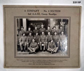
Photograph - PHOTOGRAPH WW2, BENDIGO, c.1940
Black & white photo of a group of 16 Australian Soldiers, taken in Bendigo. Black print identifies company & troops. Mounted on heavy fawn coloured cardboard.In black print above photo: “A COMPANY - NO 4 SECTION 3rd AASC, CAMP, BENDIGO” In black print below photo:BACK ROW L-R: R J Smith, L C Polgaise, H Jobling, L G Gilliam, H C Jones, H H Major, R B Ennis CENTRE ROW L-R: S H Mounsey, H Hore, Cpl F G O'Leary, Sgt O R Hamilton, Cpl P J O'Leary, J Kirby, F L Jeffery FRONT ROW L-R: D J McPherson, W R Larke” On back: Bill LARKE Murphy St Bendigo joined the Army Training Camp at Racecourse Bendigo in June 1940. Started as 3rd Australian Army Supply Service Corp. Changed to 2/32 Training Battalion (a camp was opened at Showgrounds Bendigo but closed down later). 2/32 T Battalion became 2/22 Training Battalion, they marched out of Racecourse Bendigo to Puckapunyal and became 4th Anti Tank Regiment.photography, aasc, bendigo -
 Bendigo Military Museum
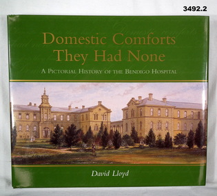
Book - BOOK, HOSPITAL, David Lloyd, Domestic Comforts They Had None, 2003
From forward: A celebration of 150 years of making the people of Sandhurst, Bendigo, the Loddon Mallee Region, etc much healthier.A pictorial history of the Bendigo Hospital. .1) Hard cardboard cover with glossy finish. 232 pages, cut, plain, glossy white. Illustrated with black / white photos, illustrations & posters. .2) Dust cover with glossy finish. .1) & .2) Gold / white print on front & spine. Covers illustrated in colour of a view of the Bendigo Gold District Hospital - undated, probably 1880's. books- military history, bendigo, hospital -
 Bendigo Military Museum
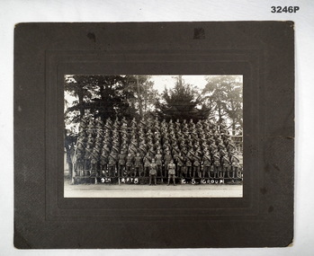
Photograph - PHOTOGRAPH, FRAMED WW1, Talma, c.1918
... in handwritten white paint: "9th RFTS, C S GROUP" Black & white photo ...60893 Private Jim BURNS, 5th Battalion, Heathcote, Victoria. Reinforced 5th Battalion in England then went to Belgium. War ceased whilst at sea. Arrived England 14.11.1918. Discharged 25.9.1919.Black & white photo of a group of Soldiers attached to dark grey heavy cardboard.In front of group in handwritten white paint: "9th RFTS, C S GROUP"photographs, framed, 5th -
 Bendigo Military Museum
Photograph - PHOTOGRAPHS WW1 - WW2, 9) Col H T ALLAN, 1) 11.11.1918; .3) c.Jul-Aug 1940; .4) & .5) c.WWII; .6), .7) & .8) post WWII; .9) - .16) 29.3.1958;
Herbert Trangmar ALLAN, refer Cat No 2755.4 for his extensive service records and awards. .3) Taken during his appointment to Headquarters of the Command & Staff School, 2nd Military District. .7) Col H T ALLAN former commander of the Pacific Islands Regiment. .10) See newspaper articles 3046.52 & 3046.53 a., b., c. .11) - .14) See newspaper articles 3046.52 & 3046.53 a., b., c. .16) The flap staff was donated by the Royal Papua & New Guinea Constabulary. See newspaper articles 3046.52 & 3046.53 a., b., c. Th photos are of various sizes with an average as per the size field. .1) Black & white full length photo of Capt Herbert T ALLAN, 17th Battalion, in Australian Army uniform from WWI, location unknown. .2) Black & white studio portrait of Herbert T ALLAN in suit & tie. Photo is mounted on cream card with a khaki border. Photo is secured in a cream card folder. .3) Black & white photo of a group of Australian Army Officers in uniform. Front row seated, rear / middle rows standing. Herbert T ALLAN seated front row 2nd from right. Headquarters of Command & Staff School in background. .4) Black & white photo of a battalion of soldiers marching down a street with sloped rifles & fixed bayonets. Battalion led by an Officer most likely to be Herbert T ALLAN. Solder on horseback in foreground. Civilian observers line the street. .5) Black & white photo of an Australian Army Officer, most likely Herbert T ALLAN, standing in front of a tent in New Guinea. .6) Black & white photo of Col Herbert T ALLAN seated, taken in New Guinea. .7) Black & white photo of Col H T ALLAN talking to 3 New Guinea natives who are possibly former members of the Pacific Islands Regiment. .8) Black & white photo of Col H T ALLAN & his New Guinean driver in an Australian Base Command jeep. .9) Black & white photo of New Guinean spectators at the opening of the Rabaul Ex-Servicemen's Club. .10) Black & white photo of Col Herbert T ALLAN with a group of PNG Ex-Servicemen. All are wearing medals. To the immediate left of Col Herbert T ALLAN is Raymond Martin, Club President. On wall behind is a rifle donated by Capt R CLAMMER of Rabaul Police. .11) Black & white photo of a presentation table to the Rabaul Ex-Servicemen, by the New Britain Boy Scouts. Club President, Raymond Martin is receiving the table with Colonel Herbert T ALLAN looking on. .12) Black & white photo of Rabaul Ex-Servicemen's Club President, Raymond Martin making a speech at the Club's opening with Colonel Herbert T ALLAN, a Naval Officer & a group looking on. Group is in front of PNG Rabaul Branch of Native Ex-Servicemen's Association building. .13) Black & white photo of the parade of PNG Ex-Servicemen, Boy Scouts & spectators at the opening of the Rabaul Ex-Servicemen's Club. .14) Black & white photo of Colonel Herbert T ALLAN inspecting a parade of PNG Ex-Servicemen at the opening of the Rabaul Ex-Servicemen's Club. .15) Black & white photo of the official party at the opening of the Papua & New Guinea Rabaul Branch Native Ex-Servicemen's Club. .16) Black & white photo of Colonel Herbert T ALLAN raising the Australian flag in front of a parade of PNG Ex-Servicemen, Boy Scouts & spectators at the opening of the Rabaul Ex-Servicemen's Club. .1) Handwritten on back: Armistice Day Nov 11th 1918. Hence the smile. .2) Printed on folder front: Portrait study by Howard Harris. Handwritten on back: Blue Allan. .3) On front: Handwritten 'X' below H T ALLAN. On back: Stamp of S J Hood photographer detailing order No 1. .5) Handwritten in pencil on back: Return to I Marsh Woolgoolga. .6) Stamped in blue ink on back: Photograph No MH 75552 Supplied by Military History Section (SD?) General? LHQ For official purpose ONLY NOT TO BE PUBLISHED .7) Stamped in blue ink on back: Photograph No MH 75553 Supplied by Military History Section (SD?) General? LHQ For official purpose ONLY NOT TO BE PUBLISHED Handwritten in pencil on back: Return to I Marsh Woolgoolga. .8) Stamped in blue ink on back: Photograph No MH 75556 Supplied by Military History Section (SD?) General? LHQ For official purpose ONLY NOT TO BE PUBLISHED photographs, articles, pacific, new guinea -
 Bendigo Military Museum
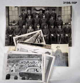
Photograph - PHOTOGRAPHS, MILITARY, (.1) June 1961
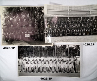
The photos all relate to the collection of Francis William (Dinky) DEAN BEM, VX93960 2nd AIF, 3472 1 RAR, 1943 - 1975. Refer Cat No 124.2 for his service details. (.1) The sign “6/58 ARA RQMS Course June 1958” ARA (Australian Regular Army) RQMS (Regimental Quarter Master Sergeant) Frank Dean is in 2nd row 1st on the right. (.2) Possibly the Officers and Senior NCO’s of 1 RAR in the late 1950’s. (.3) Some time in the 1960’s as many are wearing Vietnam ribbons. Frank Dean is 1st on the right 2nd row. (.4 - .6) “D Coy 1st Battalian of the Royal Australian Regiment”. Possibly taken in the late 1950’s. Frank Dean is in the 2nd row from bottom, 12th from the right. All photos are B & W. (.1) Large group of 25 soldiers in 3 rows with sign in front. (.2) Large group of 41 soldiers in 3 rows with building behind. (.3) Large group of 46 soldiers in 3 rows, gardens and car in background. (.4 - .6) Large group of soldiers in 3 rows with sign and flag in front.photography, military -
 Bendigo Military Museum
Photograph - PHOTOGRAPHS
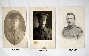
... No 3996P for information re “Lena” and other cards, photos. Photos ...The photos were in a collection of other cards and photos that were related to “Lena RICHARDSON” (.1) Believed to be "Harold Stanley RUFF" No 621, enlisted on 20.7.1915 in B Coy 29th Bn AIF age 20 years, embarked for for Egypt 10.11.1915, transferred to A.A.O.Corp, returned to Aust in1919. (.2) Believed to be "Reginald HART", (born Bendigo), No 4512, enlisted 7.7.1915 in the 14th reinforcements 6th Bn AIF age 18 years, embarked 28.1.1916, KIA 19.8.1916. The date on the card is approx one month different from actual. (.3) Believed to be "Reginald Bruce DAVIS" No 4471, enlisted 13.7.1915 in the 14th reinforcements 7th Bn AIF age 18 years, embarked 28.1.1916, transferred to the 57th Bn, returned to Aust 2.1.1919. Refer Cat No 3996P for information re “Lena” and other cards, photos.(.1) Postcard photo, B & W, portrait of a soldier in peak hat in oval shape on clear background. (.2) Postcard photo, B & W, portrait of a soldier in peak hat in a rectangular shape, clear background. (.3) Postcard photo, B & W, portrait of a soldier minus hat, clear background.(.1) On rear in black pen: “On Active service, yours sincerely H.S.RUFF Bendigo”. (.2) On rear in black pen: “With....... Private R HART, killed in action July 9th 1916” (.3) On rear in black pen; “Reg DAVIS”photos, h s ruff 29 bn, r hart 6 bn, r b davis 7th bn, ww1 -
 Bendigo Military Museum
Book - BOOK WW1, War Trophies from the First World War 1914 - 1918, 1999
Many photos throughout the book illustrate a large collection of WW1 guns. Presented to Australian towns.Cover - hard cardboard, dark blue buckram with white print on spine. Dust cover - red, white, dark blue & beige print on front & spine. Front - colour photo of a British heavy gun in action. Back - colour photos of a German 150 mm Howitzer with long barrel, dark blue background. 94 pages, cut plain white paper, illustrated with black & white photos.books, trophies -
 Bendigo Military Museum
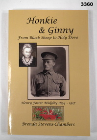
Book - BOOK WW1, Brenda Stevens - Chambers, Honkie & Ginny, 2013
Honkie & Ginny is a journey that travels from the cottages of Port Melbourne to Gallipoli, the battle fields of the Western Front and the gold fields of Bendigo. A personal tale from a grand niece.Biography. Honkie & Ginny from Black Sheep to Holy Dove - Henry Foster Midgley 1894 - 1917. Soft cardboard cover, black print on front, spine & back, yellow background. Front has 2 sepia portraits, smaller one of women superimposed over corner of soldier in uniform, small colour photo of At Peace in Flanders poppies below portraits. Back cover has colour photo of a wreath. 220 pages, cut plain paper. Illustrated in black & white photos, line drawings, posters & paintings. Handwritten in black ink on title page: "To Bendigo Memorial Museum with many thanks. Brenda S-C, August 2013" books, biography, western front -
 Bendigo Military Museum
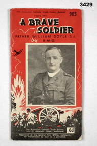
Booklet - BOOKLET WW1, The Australian Catholic Truth Society Record, A Brave Soldier, 24.6.1957
Biography of a Minister, Father William Doyle. Date of Birth 3.3.1873 in Ireland.Red colour booklet with black & white print. The centre has a black & white head to waist photo of a chaplain wearing a Sam Brown belt. Bottom section of cover has images of a soldier & a WWI 18-pounder canon firing explosives. 31 pages not illustrated.Top right in black print: “903” Printed underneath title: “Father William Doyle S J by EMG” booklet, chaplain, padre, father -
 Bendigo Military Museum
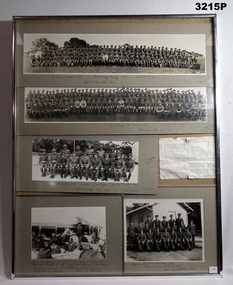
Photograph - PHOTOGRAPHS 1930'S, FRAMED, c.1934 - 38
Black & white group photos of parts of 38th Battalion 1937 & 1938 - Officers of 38th Battalion & 1934 visit to Bendigo of HRH The Duke of Gloucester & military dance invitation to be held at Drill Hall Bendigo Saturday 27.11.1937 at 8 pm. Photographs framed with silver metal frame on cardboard backing with glass front & wire hanging strap at back.Front RHS, bottom corner & LHS back sticker bearing: "No 20" On back in biro trust sticker bearing: "No 13"passchendaele barracks trust, photographs, framed, 38th -
 Bendigo Military Museum
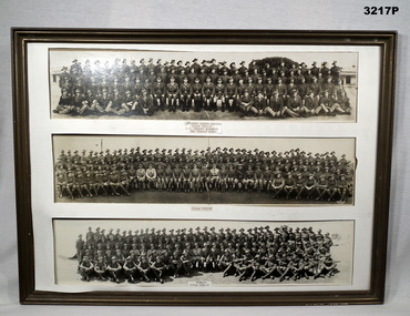
Photograph - PHOTOGRAPHS 1930'S, FRAMED, C. 1930 - 36
Photos possibly relate to the 38th Bn Post WW1.Three black & white panorama photos framed, white border, brown wooden frame & plywood backing, no glass front. Under each is text.Under top photo, "Infantry Course Portsea Circa 1930 - 1", followed by, "C.1 Beery Birewuth Adj Punch Binns" Under centre photo, "Circa 1935 - 36" Under bottom photo, "Circa Seymour 1934 - 35" RHS bottom of centre photo: "Walker Photo" RHS bottom rear sticker bearing: "Trust No 2"passchendaele barracks trust, photographs, panorama -
 Bendigo Military Museum
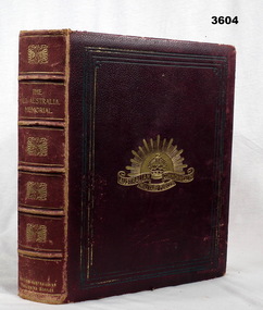
Book - BOOK WW1, Shovelton & Storey, The All Australian Memorial, 1917
The All Australian Memorial (Victorian Edition) A Historical Record of National Effort During The Great War. Australians Roll of Honour 1914 - 1916, Heroes and Helpers.Hard cardboard cover, dark red buckram, gold print on front & spine. Australian Commonwealth Military Forces badge on front. 158 cut, gold page edges, beige pages. Black / white / sepia photos, drawings, maps & portraits. Many photos mounted on cardboard mounts. Fold out photos & maps. Flyleaf & end papers are dark brown. Dedication page.Dedication page contains a card & printed portrait photo & information on Allan SCHWENNESEN “SCHWENNESEN A W, L-Cpl D Coy; 5th Batt; s. of Henry and Harriet Schwennesen 13 Arthur-St; Bendigo b. at Petersburg, S.Aust Sept 30 1897; educ. Talbot SS; clerk; enl. Bendigo, April 25, 1915 War Service; Gallipoli (Landing Evacuation); France”book, memorial, all australian -
 Bendigo Military Museum
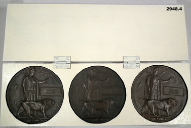
Memorabilia - MEMORIAL PLAQUES, Bickford Family, Plaques post WW1
Edward Bickford No 1519 enlisted in the AIF in the 1st reinforcements 21st Batt on 8.4.1915 age 25 years. Embarked for for Egypt 28.6.1915, embark for Gallipoli 29.8.1915, embark for France 19.3.1916, reported MIA 26.8.1916, a Court of inquiry dated 20.7.1917 found that he was KIA 26.8.1916 at Moquet Farm. Robert John Bickford No 1518 enlisted in the AIF in the 1st reinforcements 21st Batt on 8.4.1915 age 30 years 11 months. Embark for Egypt 8.4.1915, embark for Gallipoli 29.8.1915, hospital with Mumpa 20.1.1916, rejoin unit 7.3.1916, embark for France 19.3.1916, awarded the Military Medal (MM) as a Lewis Gunner and Gallantry under fire since March 1916, promoted CPL 1.9.1916, hospital with Odema of the feet 8.11.1916, rejoin unit 22.11.1916, WIA 12.1.1917 SW’s to Groin and Abdomen, DOW;s Flers 12.1.1917. William Bickmore No 815 enlisted in G Coy 14th Batt on 12.9.1914 age 21 years 11 months. Embark for Egypt 22.12.1914, embarked for Gallipoli, WIA 4.6.1915 shrapnel wound left arm, returned to Australia for discharge stating Stiffness of the Arm15.8.1915, return to Egypt in the 14th reinforcements and rejoin the 14th Batt 2.4.1916, embark for France 1.6.1916, promoted L/Cpl 1.9.1916, promoted Cpl 24.3.1917, reported MIA 11.4.1917, Court of Inquiry found he was KIA 11.4.1917 at Bullecourt. Refer 2949P, 2950P, 2991P for their photos.Bickford Family Set of WWI Commemorative Plaques: .1) Bronze Death Plaque, British pattern showing a helmeted female (Brittanica) in classic style dress holding a trident in right hand, wreath in the other & a lion at her side. In the rectangular box, embossed is the name Edward Bickford. .2) As above description though in the rectangular box is the name Robert John Bickford. .3) Descriptions as above though in the rectangular box is the name William Bickford. .4) Heavy wooden display case painted cream colour, 2 hinges on the side, no lock or catch. Inside are 3 recessed circular holes to hold the plaques.Written on rear of box is: “A.T.B. 94”military history, memorial, plaques -
 Bendigo Military Museum
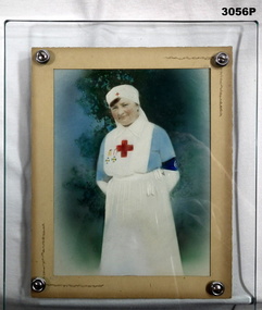
Photograph - PHOTOGRAPH, FRAMED
Photo relates to Beryl Grimshaw (Morrel) Ron Morrell, Cat No,s 306, 315, 316, 304P, 305P, 312.Heavy glass frame with thick timber backboard (smaller than glass) joined together with 4 metal screws. Beige mount. Hand tinted photo, 3/4 length portrait of female in a nurse's uniform, blue dress, white apron, sleeves, collar & veil. Red cross on apron bib & veil. Blue armband.photography - photographs, frame accessories, trades - carpentery -
 Bendigo Military Museum
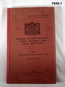
Manual - TRAINING MANUALS, 2), .3), & .4) Her Majesty's Stationery Office, Manual of Map Reading, Photo Reading, and Field Sketching, 1) 1929, Reprint 1939; .2) 1955; .3) 1957; .4) 1958
Training Manuals - War Office London 1920 - 1939. .1) Red coloured cardboard with red coloured buckram, spine, black print on front & Coat of Arms. 166 pages, cut, plain, off white paper with black & white & coloured maps & diagrams. .2), .3) & .4) Red coloured cardboard with red coloured buckram, spine, black print on front. Cut, plain, off white paper with black & white & coloured maps & diagrams. .2) 132 pages. .3) 80 pages. .4) 69 pages. .1) “1929 Reprinted with amendments No's 1 to 4 1939” .2) “1955 Part 1 Map Reading” .3) “1957 Part III Field Sketching” Front fly leaf in red ballpoint pen: “S Sgt Moore / LAD” .4) “1958 Part II Air Photo Reading”books-military history, technical, documents - maps -
 Federation University Historical Collection
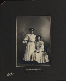
Photograph - Photograph - Black and White, Jas. Brown et al, Edith and Maud Yung and Yung Family, 1 1909
.7 Richard Henry Watson was Edith Emma Watson's (nee Yung) son. Edith Emma was also the mother of Alice Watson, artist and dressmaker, who trained at the Ballarat School of Mines in the 1930's. .1 Black and white photograph of two women, one standing and the one seated, on a grey background 1909 .2 Black and white photograph of a reverend and seven altar boys, on and dark cream background, within folder c1897 .3. First Confirmation Certificate, with prayer,1902 .4 Sepia photograph on cream background of young boy,1917 .5 Small black and white photograph with black border of young male .6 Black and white circular photograph of a woman and girl, on cream background postcard,1908 .7 Black and white photograph with white border of bride and bridesmaid,1946.1 Front: Celoron Cabinet, Edith and Maud Yung 1910. Versa: Nanna and Aunty Maud .2 Front: Rev Greenham + choir boys.Versa: 2nd from left is William John Yung (John) died at age 8 1897. Nhill, William Yung. John (second from left, died young aged 8 in Allendale. Parents John Yung and Mary Ann Sudweeks .3 Baptised Ethel Emma Yung; Confirmed 14th December 1902; First Communion 25th December 1902; Signed by C Allanby; A Daily Prayer (eight lines); Confirmed by Arthur(?) V Bishop of Ballarat. S.P.C.K. Riddle & Couchman Lith, London .4 Front bottom: Copies may be obtained. Melbourne Photographic company, *Bridge Street Ballarat*. Verso: G.A. Yung died at Ypres, Belguim 1917 .5 Front bottom:Willetts Elite Studio. RHS H. Yung. Verso: Elite Photographic Studio. Patronised by the Royal Princes and Suite. Special photographer to His Excellency the Govenor. Willetts Bridge Street Ballarat. Paper note with photo: Henry( Harrie) Yung ( George Edgar's brother) was born at Loch in Gippsland and became a railway worker. Richard Henry (Harry) Watson Edie Watson's (nee Yung) son was named after him. .6 Front: Lena and Ethel Yung Verso:Postcard: a note to her sister Miss E Yung Yendon from Lena Yung - "Dear Edie, Received PC(?) I don't know whether you know anyone here. This is Mother's cousin with me. She was up on holiday. Hoping you are all well. Love to all. I remain yours Lena." 1908. Pink postage stamp showing RAT 08 (Alice Watson, Murtoa) .7 Verso: Elite Photos 278 Flinders Lane Melbourne C.5540 Beryl Yung - bride Margaret Middleton - maid, 9th Feb 1946 POST Correspondence 4213 celeron cabinet, edith yung, reverend greenham, choir boys, john yung, william yung, mary sudweeks, nhill, allandale, ethol emma yung, c allanby, arthur b, h.yung, beryl yung, margaret middleton, elite photos, g a yung, willetts studio, elite photographic studio ballarat, confirmation certificate 1902, millinery, bride, bridesmaid -
 Bendigo Military Museum
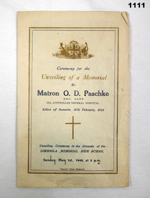
Memorabilia - NURSE MEMORIAL, 1.5.1949
Matron (Major) Olive Dorothy PASCHKE No VX38812 enlisted in the AAMC on 3.8.40 age 35 years. Promoted to Matron 8.1.1941, posted to 10th AGH on 11.1.1941, embarked for Malaya 3.2.1941 disembarking 18.2.1941, awarded the RRC 1st Class 1.1.1942 in the New Years Honors list signed by Gordon Bennett, detached to 2/4th CCS on 6.1.1942, embarked from Singapore 12.2.1942 for Australia. She was serving in Singapore when the Japanese invaded. She with many other Nurses during the bombing left on the ill fated "Vyner Brooke" which was later bombed by the Japanese in the Sundra Straits near Banka Island. Abandoning the ship she and 5 other Nurses drifted away on a raft and never seen again on 14.2.42. Many others became POW,s, drowned or murdered by the Japanese. Her records state believed killed on or after 11.2.142 dated 8.6.1944 then Now reported missing and for official purposes presumed dead, dated 11.4.1945. Records state she was granted the promotion of Major in 1943. CCS (Casualty Clearing Station) RRC ( Royal Red Cross) AGH (Australian General Hospital)Five page "order of service" re the unveiling of a memorial to "Matron O.D. Paschke RRC AANS 10th Australian General hospital." at the Dimboola Memorial High school." A sepia tone photo of O.D Paschke is stapled inside the order of service." printing is in blue & Brown. Front page has the Australian coat of arms at the top.documents - pamphlets, religon - christian, paschke, pow -
 Bendigo Military Museum
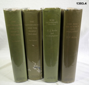
Book - BOOKS, 1) & .2) Paul Hasluck et al, Australia in the War of 1939 -1945. Series 4 Civil, 1970
Mid green buckram covers with light green dust jackets, several with plastic. Titles on front & spines. Illustrated with black & white photos & drawings. .1) Vol I The Government and the People 1939-1941,644 pages .2) Vol II The Government and the People 1942 -1945, 771 pages .3) Vol IV War Economy 1942 -1945, 817 pages .4) Vol V The role of Science and Industry, 738 pagesbooks - history, politics