Showing 3447 items
matching road bridges
-
 Eltham District Historical Society Inc
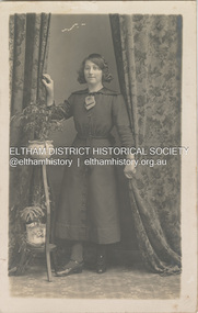
Photograph, W. Mason & Co, Believed to be Mary Ann Shillinglaw, c.1915
... . Mason & Co., 144 Bridge Road, Richmond. W. Mason & Co. operated.... Mason & Co., 144 Bridge Road, Richmond. W. Mason & Co. operated ...Post Card printed on back with photographer's details: W. Mason & Co., 144 Bridge Road, Richmond. W. Mason & Co. operated from this adress from 1903-c.1932 POSTCARD 1905-1940s Like the carte-de-visite, postcards enjoyed a collecting craze by large numbers of people, and were often kept in albums through which the interested visitor could browse. Postcards were posted or exchanged in huge numbers. Postal authorities in Australia only allowed the private printing of postcards from 1898. At this time the back of the card was reserved for the address and postage stamp, and the front was used for the message and a picture. In 1902 British authorities allowed a "divided back", so that the left side could be used for the message, the right side for the address and stamp, and the whole of the front was devoted to the picture. France followed suit in 1904, Germany and Australia in 1905, and the United States in 1907. - Frost, Lenore; Dating Family Photos 1850-1920; Valiant Press Pty. Ltd., Berwick, Victoria 1991marg ball collection, postcard, 1903-1932, 1915, mary ann shillinglaw (1880-1963), w. mason & co. photographer 144 bridge rd melbourne -
![Photograph - Digital image, House St Helena and Diamond Creek Roads [Greensborough], 02/05/2013](/media/collectors/4f729f5697f83e03086015b8/items/5729bbd22162f108e8de5be2/item-media/5729bc112162f108e8de617d/item-fit-380x285.jpg) Greensborough Historical Society
Greensborough Historical SocietyPhotograph - Digital image, House St Helena and Diamond Creek Roads [Greensborough], 02/05/2013
... the Main Street shopping centre, new and old bridges, new roads... centre, new and old bridges, new roads and houses, the Plenty ...These photographs of the house on the corner of St Helena and Diamond Creek Roads was taken in 2013 to show changes over 40 years, based on Ron Reynold's sketches in the 1973 publication 'Greensborough and Greenhills' published by Cypress Books... which states "Built on a steep hill in a bush setting in the early 1920s, for a Dr Wood, the weatherboard house now overlooks an area of activity and change. The owners, Mr and Mrs E. 'Bluey' Blackburn, remember when their 3/4 acre building block dropped to the edge of a dirt road. Today the view from the high verandah encompasses the Main Street shopping centre, new and old bridges, new roads and houses, the Plenty River, natural bush, hills and sports grounds."Digital copy of colour photograph.greensborough and greenhills, st helena road greensborough, diamond creek road greensborough, wood family, ron reynolds -
 Orbost & District Historical Society
May 1900
... was made in the way of roads and bridges, and except to the hardy... was made in the way of roads and bridges, and except to the hardy ...This is a photograph of the original Orbost / Snowy River Bridge , a suspension bridge which opened in 1893. It has been taken when the Snowy River was in flood. It is similar to other photographs held in The State Library, Victoria. The Snowy River Mail and Tambo and Croajingolong Gazette Sat 12 Aug 1893 records the opening of this bridge as "the most important public event that has yet been commemorated in Eastern ......The Messrs McLeod, with whom the first settlement of this district is generally associated, took up their residence on the eastern bank of the Snowy River about the year 1841 or 42. The late Mr W. Roadknight and Mr T. T. Stirling took possession of the territory on the western side of the Snowy about 35 years ago. During the occupation of the country by cattle owners, very little progress was made in the way of roads and bridges, and except to the hardy and lexperienced bushman, it might have been generally regarded as inaccessible. About the year 1877, however, the late Mr James Robertson eldest son of Mr James Robertson, of Lochend farm, selected land now occupied by his father, about four miles from Orbost on the west bank of the river, Mr John Cameron visited the. district shortly after a .tour of inspection and returned later with his brothers, James and Alick Gameron, but found that during their absence Mr Ernest Watt had found his way on the scene and pegged out a selection, thus anticipating the advent of the Camerons by about 12 hours. We understand that a Mr Kidd, who selected the property now occupied by Mr W. J. Ross, at Pumpkin Point, was one of the earliest batch of settlors.........."This is a pictorial record of an early bridge across the Snowy River at Orbost.A black / white photograph of a suspension bridge with flood waters below the bridge.orbost-bridge suspension-bridge snowy-river -
 8th/13th Victorian Mounted Rifles Regimental Collection
Photograph
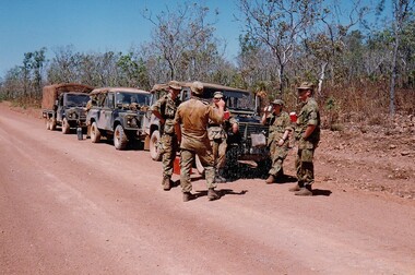
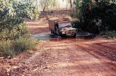
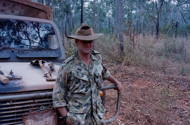
... Landrovers. The troop reported on the conditions of the roads... Landrovers. The troop reported on the conditions of the roads ...The Dibb Report into mainland defence of Australia,1986, among other things identified the requirement for protection of key assets in Northern Australia and the possibility of involving Army Reserve (Ares) units in this thus releasing regular forces for offensive operations. Dibb also pointed out that this defined role would result in a huge lift in Ares morale. In June 1988, the 3rd Division (3Div) conducted a Tactical Exercise without Troops (TEWT), Exercise ‘Distant Trumpet’ in the Katherine- Darwin area to study problems associated with defence against low level incursions against Tindal RAAF Base. Exercise ‘Northern Explorer’ followed in October of that year when units of the 3Div including A Squadron 8/13 Victorian Mounted Rifles sent patrol groups to get a first taste of environment and conditions. Post-Exercise reports had to include recommendations re: health, equipment and adaptation of Standing Operating Procedures (SOPs) in preparation for the new role deploying to Northern Australia. The first deployment by 8/13 Victorian Mounted Rifles was in 1988. Deployments continued in following years. In September 1993, 3 Troop (Wangaratta) VMR Squadron 4/19 PWLH commanded by Captain Kelvin Robertson deployed to NT. The training began with airfield defence at Tindal followed by a 1000km recon into Arnhem Land in four Landrovers. The troop reported on the conditions of the roads, airfields, bridges (mainly causeways) resources such as fuel supplies in the towns and infrastructure. Each troop taking different route. 3 Troop had the Northern route through Kakadu National park across the East Alligator River to Oenpelli then to Maningrida and Ramangining and south to the Central Arnhem Road and back to Tindal Air force Base. Colour photograph of five soldiers and three vehicles of VMR Squadron,4/19 Prince of Wales's Light Horse on roadside during annual exercise in Northern Territory 1994.military, vehicles, soldiers, northern territory, training, vmr -
 8th/13th Victorian Mounted Rifles Regimental Collection
Photograph
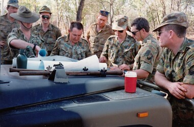
... Landrovers. The troop reported on the conditions of the roads... Landrovers. The troop reported on the conditions of the roads ...The Dibb Report into mainland defence of Australia,1986, among other things identified the requirement for protection of key assets in Northern Australia and the possibility of involving Army Reserve (Ares) units in this thus releasing regular forces for offensive operations. Dibb also pointed out that this defined role would result in a huge lift in Ares morale. In June 1988, the 3rd Division (3Div) conducted a Tactical Exercise without Troops (TEWT), Exercise ‘Distant Trumpet’ in the Katherine- Darwin area to study problems associated with defence against low level incursions against Tindal RAAF Base. Exercise ‘Northern Explorer’ followed in October of that year when units of the 3Div including A Squadron 8/13 Victorian Mounted Rifles sent patrol groups to get a first taste of environment and conditions. Post-Exercise reports had to include recommendations re: health, equipment and adaptation of Standing Operating Procedures (SOPs) in preparation for the new role deploying to Northern Australia. The first deployment by 8/13 Victorian Mounted Rifles was in 1988. Deployments continued in following years. In September 1993, 3 Troop (Wangaratta) VMR Squadron 4/19 PWLH commanded by Captain Kelvin Robertson deployed to NT. The training began with airfield defence at Tindal followed by a 1000km recon into Arnhem Land in four Landrovers. The troop reported on the conditions of the roads, airfields, bridges (mainly causeways) resources such as fuel supplies in the towns and infrastructure. Each troop taking different route. 3 Troop had the Northern route through Kakadu National park across the East Alligator River to Oenpelli then to Maningrida and Ramangining and south to the Central Arnhem Road and back to Tindal Air force Base. Colour photograph of group of soldiers of VMR Squadron 4/19Prince of Wales's Light Horse studying maps on bonnet of Land Rover during annual exercise in Northern Territory 1994.Major M. Annett wearing slouch hat, Sergeant Gary Wynn,without hat,,on his left. -
 8th/13th Victorian Mounted Rifles Regimental Collection
Photograph
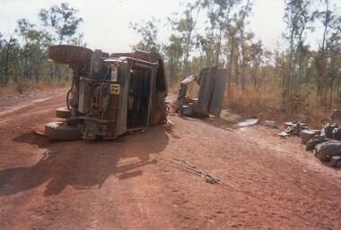
... Landrovers. The troop reported on the conditions of the roads... Landrovers. The troop reported on the conditions of the roads ...The Dibb Report into mainland defence of Australia,1986, among other things identified the requirement for protection of key assets in Northern Australia and the possibility of involving Army Reserve (Ares) units in this thus releasing regular forces for offensive operations. Dibb also pointed out that this defined role would result in a huge lift in Ares morale. In June 1988, the 3rd Division (3Div) conducted a Tactical Exercise without Troops (TEWT), Exercise ‘Distant Trumpet’ in the Katherine- Darwin area to study problems associated with defence against low level incursions against Tindal RAAF Base. Exercise ‘Northern Explorer’ followed in October of that year when units of the 3Div including A Squadron 8/13 Victorian Mounted Rifles sent patrol groups to get a first taste of environment and conditions. Post-Exercise reports had to include recommendations re: health, equipment and adaptation of Standing Operating Procedures (SOPs) in preparation for the new role deploying to Northern Australia. The first deployment by 8/13 Victorian Mounted Rifles was in 1988. Deployments continued in following years. In September 1993, 3 Troop (Wangaratta) VMR Squadron 4/19 PWLH commanded by Captain Kelvin Robertson deployed to NT. The training began with airfield defence at Tindal followed by a 1000km recon into Arnhem Land in four Landrovers. The troop reported on the conditions of the roads, airfields, bridges (mainly causeways) resources such as fuel supplies in the towns and infrastructure. Each troop taking different route. 3 Troop had the Northern route through Kakadu National park across the East Alligator River to Oenpelli then to Maningrida and Ramangining and south to the Central Arnhem Road and back to Tindal Air force Base. Two colour photographs of vehicle mishap during VMR Squadron 4/19Prince of Wales's Light Horse annual exercise in Northern Territory 1994.Second photo shows driver receiving medical attention. -
 8th/13th Victorian Mounted Rifles Regimental Collection
Photograph
... Landrovers. The troop reported on the conditions of the roads... Landrovers. The troop reported on the conditions of the roads ...The Dibb Report into mainland defence of Australia,1986, among other things identified the requirement for protection of key assets in Northern Australia and the possibility of involving Army Reserve (Ares) units in this thus releasing regular forces for offensive operations. Dibb also pointed out that this defined role would result in a huge lift in Ares morale. In June 1988, the 3rd Division (3Div) conducted a Tactical Exercise without Troops (TEWT), Exercise ‘Distant Trumpet’ in the Katherine- Darwin area to study problems associated with defence against low level incursions against Tindal RAAF Base. Exercise ‘Northern Explorer’ followed in October of that year when units of the 3Div including A Squadron 8/13 Victorian Mounted Rifles sent patrol groups to get a first taste of environment and conditions. Post-Exercise reports had to include recommendations re: health, equipment and adaptation of Standing Operating Procedures (SOPs) in preparation for the new role deploying to Northern Australia. The first deployment by 8/13 Victorian Mounted Rifles was in 1988. Deployments continued in following years. In September 1993, 3 Troop (Wangaratta) VMR Squadron 4/19 PWLH commanded by Captain Kelvin Robertson deployed to NT. The training began with airfield defence at Tindal followed by a 1000km recon into Arnhem Land in four Landrovers. The troop reported on the conditions of the roads, airfields, bridges (mainly causeways) resources such as fuel supplies in the towns and infrastructure. Each troop taking different route. 3 Troop had the Northern route through Kakadu National park across the East Alligator River to Oenpelli then to Maningrida and Ramangining and south to the Central Arnhem Road and back to Tindal Air force Base. Two colour photographs of creek crossings, one more challenging than the other,during the annual exercise in Northern Territory, conducted by VMR Squadron 4/19 Prince of Wales's Light horse, 1994. -
 Federation University Historical Collection
Book, Railway Practice: a collection of working plans and practical details of construction in the public works of the most celebrated engineers, 1847 (exact)
... (series 1 to 4)and it contains, roads, tramroads and railroads... railroads. The book includes (series 1 to 4)and it contains, roads ...A green cloth hard cover book. Title and author's name are engraved in gold on spine. This is the 3rd edition, first series with black and white illustrations. It describes the engineering practices of the early days of British railroads. The book includes (series 1 to 4)and it contains, roads, tramroads and railroads, bridges, aqueducts, viaducts, wharfs, warehouses, roofs, and sheds, canals, locks, sluices, & the various works on rivers, streams, etc., harbours, docks, piers and jetties, tunnels, cuttings and embankments, the several works connected with the drainage of marshes, marine sands, and the irrigation of land, water-works, gas-works, water-wheels, mills, engines.civil engineering, railway practice, rail constructions, s c brees, western railway great britain, public works, railroads, canals, s.c. brees, samuel brees, samuel charles brees -
 Eltham District Historical Society Inc
Photograph, Looking west near 942 Main Road, Hurstbridge, c. Oct 1987, 1987
... Road. Formerly a bakery, the building was demolished in 1990... Road. Formerly a bakery, the building was demolished in 1990 ...Yvonne's Dressmaking and Alteration Service at 942 Main Road. Formerly a bakery, the building was demolished in 1990 and is now the site of Hurstbridge Saddlery. The milkbar is down the road, brick wall with a blue sign on it. There's still an older house next to the milkbar, but that's hidden from view in this shot as it's further back from the road. Date based on other similar display panels visible in images of the Shire of Eltham display at the Eltham Community Festival, 7 November 1987. Shire of Eltham Engineering Department Providing the resources to undertake • Survey, design, consultation • Road construction and maintenance • Bridge construction and maintenance • Street sweeping • Drain and pit cleaning • Traffic engineering installation and maintenance • Garbage collection • Tip management, land reclamation and beautification • Maintenance of community buildings • Provision of community and recreation facilitiesPhoto print mounted on carddisplay panel, eltham festival, heidelberg-kinglake road, hurstbridge, hurstbridge milk bar, infrastructure, main road, mm, shire of eltham, yvonne's dressmaking and alteration service -
 Kew Historical Society Inc
Plan, J R Mathers & McMillan, 5 Splendid vVlla Allotments,: Segtoune St. & Windsor St., Kew, 1928
... Street via Bridge Road and Flinders Street. Opposite the East Kew... Street via Bridge Road and Flinders Street. Opposite the East Kew ...Prue Sanderson, in her groundbreaking ‘City of Kew Urban Conservation Study : Volume 2 - Development History’ (1988), summarised the periods of urban development and subdivisions of land in Kew. The periods that she identified included 1845-1880, 1880-1893, 1893-1921, 1921-1933, 1933-1943, and Post-War Development. These periods were selected as they represented periods of rapid growth or decline in urban development. An obvious starting point for Sanderson’s groupings involved population growth and the associated economic cycles. These cycles also highlighted urban expansion onto land that was predominantly rural, although in other cases it represented the decline and breakup of large estates. A number of the plans in the Kew Historical Society’s collection can also be found in other collections, such as those of the State Library of Victoria and the Boroondara Library Service. A number are however unique to the collection.Subdivision plans are historically important documents used as evidence of the growth of suburbs in Australia. They frequently provide information about when the land was sold on which a built structure was subsequently constructed as well as evidence relating to surveyors and real estate and financial agents. The numerous subdivision plans in the Kew Historical Society's collection represent working documents, ranging from the initial sketches made in planning a subdivision to printed plans on which auctioneers or agents listed the prices for which individual lots were sold. In a number of cases, the reverse of a subdivision plan in the collection includes a photograph of a house that was also for sale by the agent. These photographs provide significant heritage information relating house design and decoration, fencing and household gardens.In 1928, five residential allotments bordering Segtoune and Windsor Streets were advertised for sale as part of a subdivision. Four of the blocks faced Segtoune Avenue. The auctioneers proclaimed the advantages of the sites: ‘Situate one minute from the High Street Electric Tram, which now runs direct to Spencer Street via Bridge Road and Flinders Street. Opposite the East Kew Railway Station (Outer Circle Line), which may be reopened In connection with the new Line from Kew to Doncaster; Adjacent lo the Kew Recreation Reserve, Sports Oval, and Swimming Bath; Half Minute from the Shopping Centre of East Kew, Accessible to the State School and Other Educational Centres’. The Harp of Erin Hotel and the route of the Outer Circle Railway line are marked on the plan. The Recreation Reserve and Sport Oval refer to Victoria Park. The Swimming Baths were located on the site of the current Kew Recreation Centre.subdivision plans - kew, segtoune street -- kew (vic.), windsor street -- kew (vic.) -
 Eltham District Historical Society Inc
Photograph - Digital Photograph, Alan King, Alistair Knox Park, Eltham, 2008
... Place, Main Road, Bridge and Susan Streets, the park... Place, Main Road, Bridge and Susan Streets, the park ...Alistair Knox Park, an oasis of peace and beauty. Covered under National Trust of Australia (Victoria) Landscape Significance and Heritage Overlay, Nillumbik Planning Scheme. Published: Nillumbik Now and Then / Marguerite Marshall 2008; photographs Alan King with Marguerite Marshall.; p173 It is hard to imagine that the Alistair Knox Park, an oasis of peace and beauty beside busy Main Road, Eltham, was once the township’s rubbish dump. It was only in the 1970s that the tip was transformed into this beautiful six hectare space, which later earned it a National Trust Landscape classification. Before its life as a dump, the area was used for small farms. Thanks largely to the foresight and efforts of local environmental builder Alistair Knox, the park was designed sympathetically with the character of the wider Eltham landscape. Then, appropriately, the park was named after Knox, who was an Eltham Shire Councillor from 1971 to 1975 and Shire President in 1975. The park designers were four major forces in the urban bush landscape garden –Knox, landscape designer Gordon Ford, artist Peter Glass and landscaper Ivan Stranger. The National Trust citation for the park, originally called Eltham Town Park, includes the Eltham railway trestle bridge and the Shillinglaw Cottage. The citation states ‘the semi-natural setting of the parkland provides a landscape which is evocative of the history of the area’. Manna Gums (Eucalyptus viminalis) and Candlebarks (Eucalyptus rubida) are significant features. Most of the park’s construction was directed by Bob Grant, Superintendent of the Parks and Gardens Department for the Eltham Shire Council. First plantings occurred in Arbour Week in 1973, then the lake and botanic area were completed in 1975, with Federal Government funding, and the toilet block in 1978. Bounded by the Eltham railway line, Panther Place, Main Road, Bridge and Susan Streets, the park is in a valley about a kilometre wide overlooked by steep hills at the east and west. The Diamond Creek flows through it and the picturesque historic timber trestle railway bridge edges the north. Informal plantings of Australian indigenous and native species in open and undulating grassed settings blend with the natural landscape of the Diamond Creek to the west. The bush-style plants, particularly around the creek, balance with open lawns, paths and a cascade flowing from a small lake to another below. A footbridge over the creek leads to the park’s west. The park includes an adventure playground and barbecue areas. The park stands on part of the land bought from the Crown in 1851 by Josiah Holloway, who subdivided it into allotments and which he called Little Eltham. Most of the land was subdivided into residential lots, but the creek valley, on which the park stands, was subdivided into farm-size lots, used mainly for orchards and grazing. One of the earliest owners was John Hicks Petty, who in 1874 bought a plot from Holloway. Other families who owned properties in that area, included Rees, Clark, Waterfall, Graham, Hill and Morant. In 1901 the railway was built through the area. Jock Read, an Eltham resident since around 1920, remembers several farms in the 1920s and ’30s that occupied the site of today’s park. A poultry farm, which extended from present day Panther Place, was owned by the Gahan family. Next to that farm was another for grazing cattle owned by Jack Carrucan. Beside this was land owned by John Lyon. A doctor lived beside this, and at the north-west corner of Bridge Street and Main Road stood a memorial to the soldiers who died in World War One, which was later moved to the RSL site. Mr Read also remembers other farms and orchards west of the creek In the early 1960s the Eltham Council began buying these farms and in the late 1960s turned the areas east of the Diamond Creek into a garbage tip. When this was filled above the creek’s flood plain, the tip was moved to the west of the creek.This collection of almost 130 photos about places and people within the Shire of Nillumbik, an urban and rural municipality in Melbourne's north, contributes to an understanding of the history of the Shire. Published in 2008 immediately prior to the Black Saturday bushfires of February 7, 2009, it documents sites that were impacted, and in some cases destroyed by the fires. It includes photographs taken especially for the publication, creating a unique time capsule representing the Shire in the early 21st century. It remains the most recent comprehenesive publication devoted to the Shire's history connecting local residents to the past. nillumbik now and then (marshall-king) collection, alistair knox park, eltham -
 The Beechworth Burke Museum
Photograph, 1910
... Bridge Road...Taken in 1910, this photograph depicts a scene of Bridge...Bridge Road, Beechworth, VIC, Australia .... Newtown Beechworth Bridge Road 1910 J. Duncan R. McKenzie M ...Taken in 1910, this photograph depicts a scene of Bridge road in Newtown, Beechworth. Walking on the road are two men on horseback, one of which is pulling a carriage with a small dog standing beside it. Behind them are a line of small buildings and shops. Small industries began to expand dramatically in Beechworth, particularly during the 1860s, leading to a strengthening of the towns economy. As early as 1853, areas surrounding the waterway known as Spring Creek were surveyed with the intent of mapping out plans for new roads and building allotments. Land was sold and new buildings were erected, creating an expansion of the Beechworth township and retail services. One building shown in this photograph is Straughair and Duncan's Beechworth Foundry. This business was established in 1858 through the partnership of Mark Straughair and John Duncan. It dealt mostly in the manufacturing of castings and mining machinery, receiving orders from all over the Ovens district. The Business eventually collapsed after the deaths of Straughair in 1882 and Duncan in 1896 but was reopened by W.H. Phillips in 1905. The two other buildings are both associated with the name McKenzie. Evidence suggests that the McKenzie family has a long association with the town of Beechworth. This photograph is historically significant as it provides insight into the nineteenth and twentieth century industrial expansions that happened in the area of Newtown, leading to the urbanisation of Beechworth. Black and white rectangular photograph printed on matte photographic paper mounted on card.Reverse: Newton / 1997.2648 / 33 Newton Beechworth / 84-219-1 / McKenzies / BMM3055 / newtown beechworth, bridge road, 1910, j. duncan, r. mckenzie, m. straughair, industrial growth, ford street, beechworth foundry, straughair and duncan, mckenzie and sons grainstore, mckenzie family store -
 8th/13th Victorian Mounted Rifles Regimental Collection
Photograph
... Landrovers. The troop reported on the conditions of the roads... Landrovers. The troop reported on the conditions of the roads ...The Dibb Report into mainland defence of Australia,1986, among other things identified the requirement for protection of key assets in Northern Australia and the possibility of involving Army Reserve (Ares) units in this thus releasing regular forces for offensive operations. Dibb also pointed out that this defined role would result in a huge lift in Ares morale. In June 1988, the 3rd Division (3Div) conducted a Tactical Exercise without Troops (TEWT), Exercise ‘Distant Trumpet’ in the Katherine- Darwin area to study problems associated with defence against low level incursions against Tindal RAAF Base. Exercise ‘Northern Explorer’ followed in October of that year when units of the 3Div including A Squadron 8/13 Victorian Mounted Rifles sent patrol groups to get a first taste of environment and conditions. Post-Exercise reports had to include recommendations re: health, equipment and adaptation of Standing Operating Procedures (SOPs) in preparation for the new role deploying to Northern Australia. The first deployment by 8/13 Victorian Mounted Rifles was in 1988. Deployments continued in following years. In September 1993, 3 Troop (Wangaratta) VMR Squadron 4/19 PWLH commanded by Captain Kelvin Robertson deployed to NT. The training began with airfield defence at Tindal followed by a 1000km recon into Arnhem Land in four Landrovers. The troop reported on the conditions of the roads, airfields, bridges (mainly causeways) resources such as fuel supplies in the towns and infrastructure. Each troop taking different route. 3 Troop had the Northern route through Kakadu National park across the East Alligator River to Oenpelli then to Maningrida and Ramangining and south to the Central Arnhem Road and back to Tindal Air force Base Major Annett later commanded 4/19 Prince of Wales's Light Horse, and later again 4th Brigade 2nd Division.. Colour photograph of Major M. Annett, Officer Commanding VMR Squadron 4/19Prince of Wales's Light Horse during annual exercise Northern Territory 1994. -
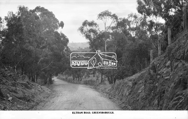 Eltham District Historical Society Inc
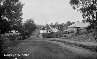
Photograph, The Rose Stereograph Company, Eltham Road. Greensborough, c.1936
... Believed to be looking east along Eltham Road towards... melbourne Believed to be looking east along Eltham Road towards ...Believed to be looking east along Eltham Road towards Eltham from around the top of the hill near the present day Andrew Yandell Habitat Reserve. Eltham Road, Greensborough followed what is now St Helena Road from Main Road Greensborough running into Karingal Drive and Sherbourne Road finishing at Bridge Street, Eltham. It was renamed sometime between 1968 and 1970. This glass plate negative was used to manufacture postcards (1:1 printing) for commercial sale by the Rose Sterograph Company and its subsidiaries. George Rose founded the Rose Stereograph Company in 1880 and was joined by Herbert (Bert) Cutts in the early 20th Century. The pair formed a lifetime working partnership and strong personal friendship. Assisted by George’s two sons, Herbert George and Walter, and later by Neil Cutts, the Rose Stereograph Company continued its operations for more than 140 years. The company was initially built on stereographs, but as cinema took over and stereographs fell out of fashion, the Rose Stereograph Company developed Australia’s first commercially viable photographic postcard business. Specialising in postcards of iconic historical moments and significant landmarks, The Rose Stereograph Company became a staple of the Australian travel industry.This remarkable collection of glass plate negatives, transparencies, and postcards – arguably Australia’s most significant photography collection outside of public hands – has been passed down through the generations, surviving war, relocation, and the harsh Victorian climate. The historic Rose Stereograph collection is the culmination of George Rose’s dream of capturing and preserving precious moments in time and remains the legacy of the Rose and Cutts families. It is with great sadness that the Cutts family says goodbye to a collection that spans five generations and 140 years. The Cutts family understands that for these historically important pieces to rest with one family is to deny others the pleasure of their custodianship.Glass Plate Negative Size: 9 x 13.9 cmEltham Road, Greensboroughpostcard, travel, rose stereograph company, glass plate negative, greensborough, cutting, eltham road, karingal drive, st helena road, peter and elizabeth pidgeon collection -
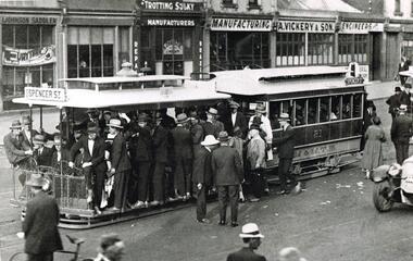 Melbourne Tram Museum
Photograph - Black & White Photograph/s, mid 1920's
... inbound in Bridge Road, c1925, lettered M&MTB... of a very crowded cable tram set inbound in Bridge Road, c1925 ...Black and white photograph of a very crowded cable tram set inbound in Bridge Road, c1925, lettered M&MTB" with the destination of Spencer St with many men crowding onto the tram. Alongside the tram is the front of a motor vehicle. Cable tram 81? In the background is a number of shops - L. Johnson Saddler, S. Christie and J Hogan (?) Trotting Sulky Manufacturers and A. Vickery & Son Manufacturing Engineers, Photo from the Collection of the Department of Infrastructure now with the Public Records Office - image number H212. Note: this photo is now out of copyright and was not an original VR photograph, but one copied from another source and collected as their Heritage series. Note from Rod Atkins 29/7/2019: The tram is full because the crowd as discharged from the racecourse so most likely taken on a Saturday. A few of buildings are still there today on the north side. Date 1920’s 2nd copy from Keith Kings added 6/8/2020 - see images i2 and i3.Has Department of Infrastructure copy right stamp on rear and number "H 212" in ink on rear and "1-10"trams, tramways, bridge rd, spencer st, cable trams, tram 81 -
 Orbost & District Historical Society
black and photograph / postcard, 1.4.1908
... little progress was made in the way of roads and bridges... little progress was made in the way of roads and bridges ...This postcard was sent to Annie Gilbert (Mrs John Gilbert) of Tullagoota, Orbost. It was written by "Grace", probably her sister, Grace Cameron Annie Gilbert was the daughter of John Cameron who selected the first land on the Snowy River flats. This is a photograph of the original Orbost / Snowy River Bridge , a suspension bridge which opened in 1893. It has been taken when the Snowy River was in flood. It is similar to other photographs held in The State Library, Victoria. The Snowy River Mail and Tambo and Croajingolong Gazette Sat 12 Aug 1893 records the opening of this bridge as "the most important public event that has yet been commemorated in Eastern ......The Messrs McLeod, with whom the first settlement of this district is generally associated, took up their residence on the eastern bank of the Snowy River about the year 1841 or 42. The late Mr W. Roadknight and Mr T. T. Stirling took possession of the territory on the western side of the Snowy about 35 years ago. During the occupation of the country by cattle owners, very little progress was made in the way of roads and bridges, and except to the hardy and lexperienced bushman, it might have been generally regarded as inaccessible. About the year 1877, however, the late Mr James Robertson eldest son of Mr James Robertson, of Lochend farm, selected land now occupied by his father, about four miles from Orbost on the west bank of the river, Mr John Cameron visited the. district shortly after a .tour of inspection and returned later with his brothers, James and Alick Gameron, but found that during their absence Mr Ernest Watt had found his way on the scene and pegged out a selection, thus anticipating the advent of the Camerons by about 12 hours. We understand that a Mr Kidd, who selected the property now occupied by Mr W. J. Ross, at Pumpkin Point, was one of the earliest batch of settlers.........."This item is associated with Annie Gilbert (nee Cameron) reported to have been the first white girl to be born in Orbost. It is a pictorial record of the suspension bridge over the Snowy River which has since been replaced twice.A faded black / white postcard of a bridge across a river. There are cattle in the river and the banks are tree-covered.on back - a hand-written letter addressed to Mrs J. Gilbert Tullagoota Orbost.cameron-annie suspension-bridge-orbost snowy-river-orbost -
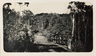 Kew Historical Society Inc
Photograph - Rural landscape, c.1926
... undertaken solely or with a companion/s. This photo is a country road... or with a companion/s. This photo is a country road with a wooden bridge ...Henry Beater Christian (1886-1962) , was a descendant of one of the earliest settler families in Kew. Employed at the Kew Asylum as a 'public servant', he was a skilled amateur photographer, photographing numerous scenes in Kew and on his travels around Victoria. The majority of his photographs date from 1916 to 1929. His finest photographs are housed in two photograph albums. Digital copy of a photograph from page 17 of the 47-page photograph album containing 261 gelatinous silver images, loaned by Diane Washfold with permission given to digitise and hold a copy in our collection. This photograph, dating from c.1926, forms part of a group of photos preceding images of [Black] Spur, so the photographs may have been taken as part of that bushwalking trip. John Chapman has written in 'Bushwalking Clubs - A Brief History', about the establishment in Victoria of the first bushwalking club in 1888, and the popularisation of bushwalking during the interwar period. Henry Christian's 'walks' appear to have been undertaken solely or with a companion/s. This photo is a country road with a wooden bridge on which a man is sitting. Illegible ink inscription on pagehenry beater christian (1886-1962), landscape photography, kew (vic.) — yarra river, christian-washfold collection, photograph albums, bushwalking -- victoria -
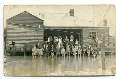 Orbost & District Historical Society
black and white photograph, poss. 1920
... fences, bridges and roads, dumping silt and debris on the rich... fences, bridges and roads, dumping silt and debris on the rich ...In the photograph are the Rice family, Billy Nixon' family and Charlie Johnston. William Nixon, son of James Nixon and Alice (Roberts) Nixon was married to Ilma Muriel (Cadwallader) Nixon on 2 Apr 1902 in Orbost. They had six children - Llewella Adele (Nixon) King, Sydney William Columbo Nixon, Arthur Harry Nixon, Jack Warton Nixon, Claudine Frances (Nixon) Taylor and Daphne Joyce (Nixon) Menz Damage estimated at £500,000 was caused by the 1934 floods in the Orbost district. This 1934 flood was devastating, destroying a section of the 1922 Orbost bridge, wrecking fences, bridges and roads, dumping silt and debris on the rich river flats and drowning cattle. Note: although this card has the date 1934 written onto the rear, the flood incident depicted most likely dates from 1920 (ref. Weekly Times, Saturday 6 March 1920 p 41 when this photo was printed).This item is a pictorial record of a flood in 1920 (ref. Weekly Times, Saturday 6 March 1920 p41). Snowy River flood are a feature of the Orbost area. These floods cover the rich agricultural land. A black / white photograph / postcard of a group of people standing in floodwaters outside a timber building. Included are young children and babies being held by women. Two boys are holding dogs in front of them.on back - "Billy Nixon's house (now Downys 1991)"orbost - floods - nixon - 1920 -
 Eltham District Historical Society Inc
Photograph, Fay Bridge, Clifton Pugh's Artists' Colony, Dunmoochin, Barreenong Road, Cottles Bridge, 14 May 2016
... Clifton Pugh's Artists' Colony, Dunmoochin, Barreenong Road... acres (2.4 ha) of land at Barreenong Road, Cottles Bridge. He... to purchase six acres (2.4 ha) of land at Barreenong Road, Cottles ...Following military service in the second world war, Clifton Pugh studied under artist Sir William Dargie at the National Gallery School in Melbourne as well as Justus Jorgensen, founder of Montsalvat. For a while he lived on the dole but also worked packing eggs for the Belot family saving sufficient to purchase six acres (2.4 ha) of land at Barreenong Road, Cottles Bridge. He accumulated more land and persuaded several other artists and friends to buy land nearby, resulting in a property of approximately 200 acres, stablishing it as one of the first artistic communes in Australia alongside Montsalvat in Eltham. It was around 1951 that Pugh felt he had '"done moochin' around" and so the name of the property evolved. He bought timber from Alistair Knox to build his house on the crest of a hill. Inspired by local goldminer's huts, it was a one room wattle-and-daub structure with dirt floor. Over the years it expanded with thick adobe walls made from local clay, high ceilings and stone floors. All materials other than the local earth were sourced from second hand materials, most found at wreckers' yards. Artists from across the nation were drawn to Dunmoochin, with several setting up houses and shacks on the property, maintaining their independence but sharing their artistic zeal. Artists who worked or resided at Dunmoochin included Mirka Mora, John Perceval, Albert Tucker, Fred Williams, Charles Blackman, Arthur Boyd and John Olsen. In 2002, Pugh's house along with its treasure trove of art and a library of some 20,000 books was destroyed by fire. Traces of Pugh's home remain with the presence of the Victorian doorframe archway with leadlight of intricate design, procured from a demolished Melbourne mansion; and two bronze life-sized female statues created by Pugh and cast by Matcham Skipper. In place of Pugh's house rose two double-storey mud-brick artists' studios topped with corrugated iron rooves curved like the wings of a bird with accommodation for seven. The original studios, gallery and other buildings survived the fire.fay bridge collection, 2016-05-14, art gallery, barreenong road, clifton pugh, cottles bridge, dunmoochin, maurice hurry -
 Eltham District Historical Society Inc
Postcard - Photograph, Eltham from Greensborough Road, No. 1, c.1910
... (present-day Sherbourne Road) across Bolton and Bridge streets... (present-day Sherbourne Road) across Bolton and Bridge streets ...The view is looking southeast from near Eltham Road (present-day Sherbourne Road) across Bolton and Bridge streets towards the village of Little Eltham running down the main road (Maria Street) . On the immediate right is Mrs Mary Jane Smart's family home located on the north side of Bridge Street at the intersection with Bolton Street, facing Bolton Street (now part of present day Brisbane Street and occupied by the Kitchen Design Centre). An original early settler's cottage, it was built by Mary Jane Smart's parents, Edwin Bailey and Jane (nee Matthews). Mary Jane Smart was born in the cottage. She married an Englishman, Alexander Wilson Smart who disappeared to Western Australia in the early 1900s in search of gold. He ultimately married again in W.A., committing bigamy and then committed murder and was hung in 1911. Visible at the top left are Watson's (two-storey) Eltham Hotel at the corner of Pitt Street and Maria Street and the Evelyn Hotel directly opposite.Sepia postcardNotations in biro 'A. Petrie', rest in pencil as follows St Margarets N end Shows Wesleyan Church Small Bank Double Storey on Hotel's south end Pearsons house Note roof structure Surface damage to lower left corner1910, bridge street, cba bank, church, clark bros. photo, early settlers, eltham, eltham hotel, evelyn hotel, fountain of friendship hotel, greensborough, mary jane smart (nee bailey), pearson house, pre 1900, road no 1, smart family home, smart home, st margarets, watsons hotel, wesleyan church -
 Melbourne Tram Museum
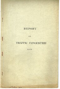
Document - Report, Road Board, "Report on Traffic Congestion", 1919
... on growth of Melbourne, railways, tramways, new arterial roads..., tramways, new arterial roads, subways, new bridge at Spencer St ...Report - 26 pages, printed, contained and stapled within a grey "Roneo Numeralpha System" folder, titled "Report on Traffic Congestion", containing a Victorian Parliamentary Report, dated 1919 with titled "Report of Board appointed to investigate the problem of relieving congestion of traffic in Melbourne." Full title "Report of Board Appointed to Investigate the problem of Relieving Congestion of Traffic in Melbourne" The Board or "Traffic Board" comprised 5 representatives of Councils, MMTB, Railways and the Public Works Department includes comments on growth of Melbourne, railways, tramways, new arterial roads, subways, new bridge at Spencer St, regulation of street traffic, looks at new tramway routes, hours works and provides a summary of recommendations including drawings for new arterial roads, graphs and roads / tramway layouts in two chain wide roads. Note: This document is available as a pdf on the Parliament of Victoria website. Second copy - unbound as printed, stapled on the left hand side, from McComb collection, box 10 - added 5/1/2017. added a 2nd copy from Russell Jones (28/05/22). Poor quality copy.Has in ink on the bottom edge "17th June 1919", Copy 2 - "H. Lormer"? in ink in the top right hand corner.trams, tramways, mmtb, general scheme, tramways, development, parliament, spencer st, railways, finances, construction, traffic control -
 Eltham District Historical Society Inc
Photograph, Tess Justine (Nillumbik Shire Council), Construction work on replacement of Murray's Bridge over the Diamond Creek, Eltham North, 31 Mar 2022
... by road, with only an old low-level bridge over Diamond Creek... by road, with only an old low-level bridge over Diamond Creek ...Construction work on replacement of Murray's Bridge over the Diamond Creek on the Diamond Creek Trail Mary (Sweeney) Murray and John Wright Murray selected 80 acres, Lot C Section 16 and Lot 5 Section 17 Parish of Nillumbik, under an occupation license in 1866. John died in 1867 and freehold was granted to his son John in 1873. The farm was known as ‘Laurel Hill’. John Junior was an Eltham Shire councillor and sometime president from 1887 up until 1897. He added Lot A Section 16 to the farm in ca1888. John and his younger brother James arranged to rent/purchase Lot B Section 17, across Diamond Creek to the west, in ca1900. It appears that John and James farmed separately for a few years, with a new homestead built for James ad family on the high point of Lot B Section 17 in ca1910. John sold off Lot 5 Section 17 in 1912. When John died in 1912 James took over the land on both sides of the Diamond Creek. The old homestead on the west side of the Creek disappeared. A farm bridge over Diamond Creek from this period may have been located close to the northern boundary of the farm. John Langlands, owner of the farm known as ‘Ihurst’ on the west side of Diamond Creek to the south of the Murray’s land, died in 1907. In 1909 his land was then subdivided into 100 lots to become the ‘Glen Park Estate’. Other similar subdivisions of nineteenth century farms around Eltham in this period included the ‘Franktonia (or Beard’s) Estate’ to the northeast and ‘Bonsack’s Estate’ between Eltham and Greensborough. Soon after the opening of the railway extension line from Eltham to Hurstbridge in 1912, Glen Park and nearby residents including James Murray agitated for a railway station or siding to be located half-way between Eltham and Hurstbridge, so that the Glen Park residents who used the railway daily did not have to walk into the Eltham or Hurstbridge stations. Some believed Coleman’s Corner (opposite Edendale Farm) was an appropriate spot for the platform. James Murray was among those who thought the railway should be located on his land, closer to half-way between Eltham and Hurstbridge stations. The Railways Commissioners warned that the locals would have to fund these works themselves. The Glen Park Estate residents initially had difficulty accessing Eltham by road, with only an old low-level bridge over Diamond Creek at the south end of their estate. A new timber trestle bridge across the creek, now on Wattletree Road, was opened in 1915. Road access to the north was gained in 1927 when the new Murray’s Road, which crossed the Murray’s land, was built. Residents continued to agitate for a Glen Park station. By 1926 the Railways Commissioners’ preferred site was on the Murray’s land. They arranged an estimate of cost of a full-length platform. The estimate was too much for the locals, who in 1928 argued unsuccessfully for a shorter and hence cheaper platform. By 1929 Murray had agreed to donate the land, but the locals would still have to fund the works. Murray decided, unilaterally it would appear, to commence work on a timber trestle road bridge over Diamond Creek to link the new Murray Road to the proposed station. Late in 1929 he stopped work on the bridge, for reasons unknown, but started work again and completed the bridge in 1931. There is no further newspaper evidence of the campaign for the Glen Park station until 1939, when Murray and another local, Mr Maxwell, met the Railways Commissioner. The Glen Park locale now included 45 homes on the west side of the creek and 20 on the Eltham side. Most of the residents used the train every day. The Commissioner remained adamant that only a full-length platform could be built for safety reasons. It appears the campaign dissolved at this point. The increasing move to cars may have had an impact. There is no evidence of Murray’s bridge ever being connected to Murray’s Road, or of it having wide use for any purpose by locals. James Murray died in 1947 and the farm was taken over by his son James (Jim). Jim started to sell off parts of the farm in the 1980s, retaining a few acres around the ca1910 homestead and building a new house there. Recreation reserves were established along the creek. In ca1990 Murray’s bridge was renovated with steel girders as part of a bike/pedestrian path in the reserve. The old farmhouse was demolished in ca2014. Born digital image (5)diamond creek (creek), diamond creek trail, murrays bridge, ‘laurel hill’, john wright murray, mary (sweeney) murra, john murray jnr, james murray, john langlands, ‘ihurst’, ‘glen park estate’, beard's estate, franktonia, bonsack's estate, glen park estate, glen park railway station -
 Eltham District Historical Society Inc
Photograph, Fay Bridge, Clifton Pugh's Artists' Colony, Dunmoochin, Barreenong Road, Cottles Bridge, c.1995
... Clifton Pugh's Artists' Colony, Dunmoochin, Barreenong Road... to purchase six acres (2.4 ha) of land at Barreenong Road, Cottles... Collection 1995 Barreenong Road Cottles Bridge dunmoochin 5 images ...Visit to Dunmoochin prior to Clifton Pugh's home being destroyed by fire in 2002. Following military service in the second world war, Clifton Pugh studied under artist Sir William Dargie at the National Gallery School in Melbourne as well as Justus Jorgensen, founder of Montsalvat. For a while he lived on the dole but also worked packing eggs for the Belot family saving sufficient to purchase six acres (2.4 ha) of land at Barreenong Road, Cottles Bridge. He accumulated more land and persuaded several other artists and friends to buy land nearby, resulting in a property of approximately 200 acres, stablishing it as one of the first artistic communes in Australia alongside Montsalvat in Eltham. It was around 1951 that Pugh felt he had '"done moochin' around" and so the name of the property evolved. He bought timber from Alistair Knox to build his house on the crest of a hill. Inspired by local goldminer's huts, it was a one room wattle-and-daub structure with dirt floor. Over the years it expanded with thick adobe walls made from local clay, high ceilings and stone floors. All materials other than the local earth were sourced from second hand materials, most found at wreckers' yards. Artists from across the nation were drawn to Dunmoochin, with several setting up houses and shacks on the property, maintaining their independence but sharing their artistic zeal. Artists who worked or resided at Dunmoochin included Mirka Mora, John Perceval, Albert Tucker, Fred Williams, Charles Blackman, Arthur Boyd and John Olsen. In 2002, Pugh's house along with its treasure trove of art and a library of some 20,000 books was destroyed by fire. Traces of Pugh's home remain with the presence of the Victorian doorframe archway with leadlight of intricate design, procured from a demolished Melbourne mansion; and two bronze life-sized female statues created by Pugh and cast by Matcham Skipper. In place of Pugh's house rose two double-storey mud-brick artists' studios topped with corrugated iron rooves curved like the wings of a bird with accommodation for seven. The original studios, gallery and other buildings survived the fire.fay bridge collection, 1995, barreenong road, cottles bridge, dunmoochin -
 Melbourne Tram Museum
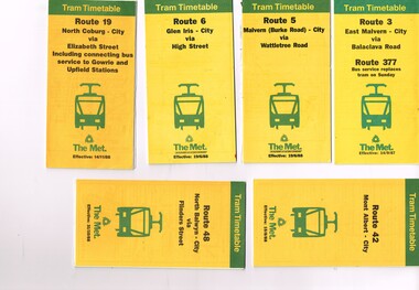
Ephemera - Timetable, The Met, Set of 12 Tram Timetables, produced by The Met, 1987 - 1989
... Road - 14/9/1987 .11- Route 70 - Wattle Park (Elgar Road... 70 - Wattle Park (Elgar Road) Princes Bridge via Swan St - 31 ...Set of 12 Tram Timetables, produced by The Met for various routes, yellow cover with a green top band, multi fold horizontal sheet, giving a route map, description, notes, time points, information contact details and types of tickets (Neighbourhood and Travelcards) and where they could be purchased. .1 - Route 3 - East Malvern - City via Balaclava Road - replaced by bus 377 on Sundays - dated 14/9/1987 .2 - Route 5 - Malvern Burke Road - City via Wattletree Road - 19/6/1988 .3 - Route 6 - Glen Iris - City via High St - 19/6/1988 .4 - Route 19 - North Coburg - City via Elizabeth St including connecting bus service to Gowrie and Upfield stations - 14/11/1988 .5 - Route 42 - Mont Albert - City - 15/8/1988 .6 - Route 48 - North Balwyn - City via Flinders St - 31/10/1988 .7 - Route 55 - West Coburg - Domain Interchange via William St - 11/2/1987 .8 - Route 57 - West Maribyrnong - City via North Melbourne - Route 357 bus replaces tram on Sunday - 27/8/1989 .9 - Route 59 - Airport West - City via Essendon - 27/8/1989 .10 - Route 64 - East Brighton - City via Hawthorn Road - 14/9/1987 .11- Route 70 - Wattle Park (Elgar Road) Princes Bridge via Swan St - 31/10/1988 .12 - Route 86 - Bundoora - City via West Preston - 15/8/1988 Full Image of .4 added 9/4/17 following a query about route 19 timetables - see image i5.trams, tramways, timetables, tickets, tram services, route 3, route 5, route 6, route 19, route 42, route 48, route 55, route 57, route 59, route 64, route 70, route 86 -
 Bendigo Historical Society Inc.
Financial record - Invoices 1892 - 1902, 31/01/2017
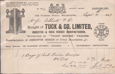
... Merchants, 206 Bridge Road, Richmond. October 19th, 1888, quotation.... Kennon & Sons, Tanners, Curriers & Leather Merchants, 206 Bridge ...8545a Docket from Tuck & Co. Limited, Asbestos & India Rubber Manufacturers, 4566 Collins Street, Melbourne; Sept. 4th, 1889; Head Office: 116 Cannon Street, London. Purchased 3 Bags of Asb. Boiler ?? at a cost of £3/- by Messrs. Abbitt & Co. 8545b Docket from G. Wood, General Founder, Kensington Iron Foundry, Macauley Road, dated Dec. 2nd, 1896; due from Mr. J. H. Abbott, For 1 doz. combination parts& 1/2 doz. stands for parts at £1/14/00. 8545c Memorandum James Oppy, Boot and Shoemaker, Fitzroy Street, Kerang, dated Aug. 23rd, 1893. Apology and advice the amount owing will be forwarded on 1st of next month (Sept.). 8545d Docket for six items purchased by Messrs. J.H. Abbott, Bendigo for £63/16/00 from The Australian Explosives & Chemical Coy. Ltd on Aug. 5, 1902. Manufacturers and Importers of High Explosives and Detonators, 356 Little Collins Street, Melbourne 8545e Docket / quote from J. Kennon & Sons, Tanners, Curriers & Leather Merchants, 206 Bridge Road, Richmond. October 19th, 1888, quotation sent to Mr. J H Abbott, Leather Merchant, Sandhurst.bendigo businesses, j. kennon and sons, tuck and co, g. wood, james oppy, the australian and chemical coy -
 Eltham District Historical Society Inc
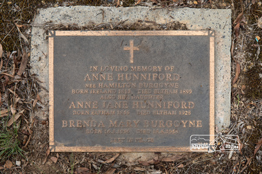
Photograph, Peter Pidgeon, Grave of Anne Hunniford (nee Hamilton Burgoyne) and Anne Jane Hunniford, Eltham Cemetery, Victoria, 5 April 2021
... in Maria Street (now Main Road) near Bridge Street (originally... in Maria Street (now Main Road) near Bridge Street (originally ...On February 1, 1854, the first Eltham Post Office was established. At that time, the number of permanent residents would have been fairly small, probably less than 200. In 1855 Thomas Hunniford was appointed as Eltham's postmaster (replacing Frederick Falkiner). He operated the post office from his general store in Maria Street (now Main Road) near Bridge Street (originally facing Bridge Street but later altered to face Main Road). His daughter, Miss Anne Hunniford, was a teacher at Eltham Primary School in her early adult years. Sometime between 1864 and 1868 the management of the post office passed from Thomas Hunniford to his daughter, Anne who managed the Eltham Post Office until illness forced her to retire in 1928. A big improvement in communication was provided for Eltham residents when a telegraph office was established at the post office in 1877. During 1923 a manual telephone exchange was provided at Eltham, the first two subscribers being J.J. O’Connor and Eltham Police Station. Anne was succeeded by her nephew Neville Burgoyne whose family were then running the store, which had been rebuilt and modernised in 1926 to accommodate an expanded post and telegraph office. Anne knew everyone and was respected for her kindly actions in her official and private capacities. In her time there was no official letter delivery to houses; residents were expected to collect their mail at the post office. But if an important letter or telegram arrived, Anne would try to find someone willing to deliver it. Jock Read recalled he started his own private "mail run"; he would charge people 1/- per week to take their letters to the post office for mailing and would return with their mail. Anne died in 1928, aged 73. She is buried in Eltham Cemetery with her mother and with a Burgoyne child born much later. Burgoyne's store was further extended in 1940 and still stands though has undergone several modifications and businesses. In 1954 the post office moved to a shop in the main Eltham shopping centre, then in 1958 a purpose-built post office was opened near the entrance to the railway station. In Loving Memory of Anne Hunniford Nee Hamilton Burgoyne Born Ireland 1813 Died Eltham 1899 Also her daughter Anne Jane Hunniford Born Eltham 1855 Died Eltham 1928 Brenda May Burgoyne Born 16. 8. 1956 Died 18. 6. 1958 Rest In PeaceBorn Digitaleltham cemetery, gravestones, anne hunniford (nee hamilton burgoyne), anne jane hunniford, brenda mary burgoyne -
 Eltham District Historical Society Inc
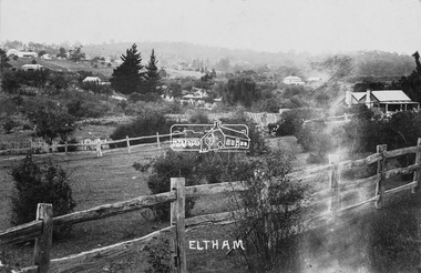
Negative - Photograph, Main Road, Eltham, c.1915
... in albums. This scene is viewed looking north along Main Road from... in albums. This scene is viewed looking north along Main Road from ...Sending postcards to family and friends including short messages was a common form of communication in the early 20th century from 1905 to the 1940s. Many were collected and kept in albums. This scene is viewed looking north along Main Road from near Bridge Street. The old Baker’s shop (Burgoyne’s store) on the corner of York is on the right. Also visible is the footpath dug by hand c.1906 between Yoirk Street and Bridge Street. On the left is ‘Derril’ or more commonly known as the Gahan House after it was purchased by Walter Ernest and Alice Miriam Gahan in 1924, on the western side of Main Road near the present-day site of Shillinglaw Cottage where they remained till about 1960 when Walter died. The house was demolished in 1968 during the widening of Main Road. In the distance on the bend is the Shillinglaw cottage with the Shillinglaw trees out front of the cottage. On the eastern side at the top of the hill (visible immediately to the left of the bakery) is the new St Mary’s Catholic Church on Henry Street near Main Road. The church site was relocated c.1912 from further south along Main Road (near Wingrove Cottage) in order to be more central to the congregation following the shifting of the township away from Little Eltham and closer to the railway station. It was subsequently destroyed by fire in 1961. On the back of the postcard is written: Printed Post Empire Care - correspondence - Address only - stamp Written in ink: 15 ? 1920 Many happy of the day I hope you and ? will have a very pleasant trip ? a great time when you reach England. ? & best wishes from your sincere friend E Harper?This photo forms part of a collection of photographs gathered by the Shire of Eltham for their centenary project book,"Pioneers and Painters: 100 years of the Shire of Eltham" by Alan Marshall (1971). The collection of over 500 images is held in partnership between Eltham District Historical Society and Yarra Plenty Regional Library (Eltham Library) and is now formally known as the 'The Shire of Eltham Pioneers Photograph Collection.' It is significant in being the first community sourced collection representing the places and people of the Shire's first one hundred years.Digital image 4 x 5 inch B&W Neg Sepia Postcard 9 x 14 cm 35mm positive transparencyshire of eltham pioneers photograph collection, eltham, main road, gahan house, bakery, footpath, postcard, shillinglaw cottage, shillinglaw trees, st marys catholic church, york street, michael aitken collection -
 Eltham District Historical Society Inc
Photograph (item), J.H. Clark (poss), View of Eltham across Bridge Street, c.1907
... (present-day Sherbourne Road) across Bolton and Bridge streets... (present-day Sherbourne Road) across Bolton and Bridge streets ...The view is looking southeast from near Eltham Road (present-day Sherbourne Road) across Bolton and Bridge streets towards the village of Little Eltham running down the main road (Maria Street) . On the immediate right is Mrs Mary Jane Smart's family home located on the north side of Bridge Street at the intersection with Bolton Street, facing Bolton Street (now part of present day Brisbane Street and occupied by the Kitchen Design Centre). An original early settler's cottage, it was built by Mary Jane Smart's parents, Edwin Bailey and Jane (nee Matthews). Mary Jane Smart was born in the cottage. She married an Englishman, Alexander Wilson Smart who disappeared to Western Australia in the early 1900s in search of gold. He ultimately married again in W.A., committing bigamy and then committed murder and was hung in 1911. Visible att the top left are Watson's (two-storey) Eltham Hotel at the corner of Pitt Street and Maria Street and the Evelyn Hotel directly opposite. The photo was possibly taken by John Henry Clark of Clark Bros Photographers who operated from 25 Thompson Street, Windsor near Prahan 1894-1914.bridge street, clark bros. photo, early settlers, eltham, evelyn hotel, fountain of friendship hotel, j.h. clark photo, mary jane smart (nee bailey), smart family home, smart home, watsons hotel -
 Greensborough Historical Society
Oral History Transcript, Myrtle Barnett 19/02/1996, 19/2/1996
... walk straight down the road and over the bridge... Park and could walk straight down the road and over the bridge ...Oral history Myrtle Barnett ( 1915- ); fostered daughter of Caroline & Ferdinand Barnett; Lower Plenty. Interviewed on 19 Feb 1996 by Peter Blackbourn. "We lived at Grace Park and could walk straight down the road and over the bridge to the Montmorency State School. The school was in Rattray Rd about half way up the hill. The King family lived next door to the school. One day the students were all taken on a walk to choose the site of the new school (which was built in 1924). In addition to the above story; Myrtle said at either the Lower Plenty School or the Montmorency School there was a teacher they didn’t like so they swapped schools. My Grandmother Jean Barnett; started at Greensborough Primary in 1919 and stayed 3 months. When I told her about this; she told me off and said she never went there! She must have then gone to Montmorency and when there was a call to start a school at Lower Plenty; took the opportunity to get away from the teacher they didn’t like. I’m not sure of the time line for the above events; or which school they swapped to but I thought it gave a little insight into the 1920’s and how Lower Plenty; Montmorency and Greensborough were connected."Transcript of Oral History. barnett family, myrtle barnett -
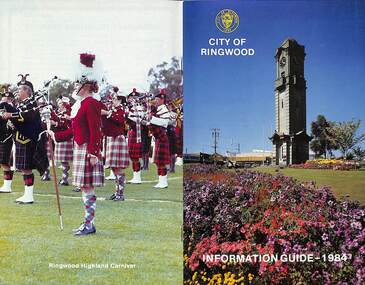 Ringwood and District Historical Society
Booklet, City of Ringwood Information Guide - 1984, 1984
... By-Laws/Traffic Regulations 22 Canterbury Road Railway Bridge... Canterbury Road Railway Bridge Widening 34 Commissioners for Taking ...Community information booklet issued by City of Ringwood for 1984 - covering the facilities and activities of the Ringwood Council and other local organisations and associations.CONTENTS: (page no.) Building - General Information 23 By-Laws/Traffic Regulations 22 Canterbury Road Railway Bridge Widening 34 Commissioners for Taking Declarations and Affidavits 24 Council Elections 11 Council Representatives 1983/1984 7 Council Structure. 10 Deferment of Rates 11 Emergency Telephone Numbers 59 Employment Initiatives Programme 32 European Wasps 26 Facilities for Disabled Persons 15 From the Chief Executive Officer 8 Garbage 20 Genera] Use Buildings 39 Historical Museum 29 Home Help Service 14 Immunisations - Health Care 12 Immunisation Programme - 1984 13 Justices of the Peace 23 Library Service for Senior Citizens 15 Maintenance of Facilities 34 Management Executive 9 Mayor’s Message – Cr. F.J. Corr 2 Meals on Wheels 14 Members of Parliament 25 Parking Signs and Street Names 35 Pedestrian Hazards 36 Pensioner Rate Assistance Scheme 12 Property Records 11 Rates 11 Re-Cycling of Waste 21 Ringwood Centre (Hostel) for the Frail Aged 17 Ringwood Cultural Centre 40 Ringwood Festival 28 Ringwood Golf Course. 36 Ringwood Highland Carnival 28 Ringwood Lake Reserve 29 Ringwood Library 17 Shopping Centre Studies 38 Staley Gardens 32 Standing Committees of Council 6 Swimming Centre 37 Welfare and Community Services 41 rinx