Showing 575 items
matching road construction building
-
 Melbourne Tram Museum
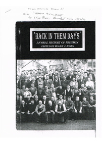
Document - Photocopy, Roger J. Jones, "Back in Them Days' ", c1992/93
Photocopy of cover and five pages extracted from a publication - "Back in Them Days' " - an oral history of Preston edited by Roger J. Jones. Extract features "Tram building" at Preston workshops, features an interview with Clive Boxer. Worked at the workshops 1925 for 6 years, through to 1974, described the construction of trams, working conditions, working hours, the bosses, Industrial relations, wages, repairs, overhauls, working during the depression, and work done during the war.Has in ink on the front cover "Please return to John" item "Tram building" by Clive Boxer, recorded c 1992/93.trams, tramways, preston workshops, oral history, preston, tram bodies -
 Melbourne Tram Museum
Album - Photo Album, Melbourne & Metropolitan Tramways Board (MMTB), Construction of depots and workshops, mid 1920's
Photo Album - brown manila card sheets as covers, containing 20 blue card sheets trimmed with white binding tape and held by two brass clips, containing the following photographs: South Melbourne depot - substation, construction, steelwork, inspection pits, offices, girders. overhead stores Preston Workshops - body shop, timber sheds, machine shop, steelwork, crane runways Sydney Harbour bridge steelwork. Three loose photos. For individual photo images of each page see: \dbtext\hawthtramcoll\photo collections\htd5526 - KC Painter Material /Early MMTB Depots-album images KCP01 to KCP20 KCP01_MMTB-depot-construction_cover.jpg KCP02_SouthMelbourne-1.jpg KCP03_SouthMelbourne-2.jpg KCP04_SouthMelbourne-3.jpg KCP05_SouthMelbourne-4.jpg KCP06_SouthMelbourne-5.jpg KCP07_PrestonWorkshops-1.jpg KCP08_PrestonWorkshops-2.jpg KCP09_PrestonWorkshops-3.jpg KCP10_PrestonWorkshops-4.jpg KCP11_PrestonWorkshops-5.jpg KCP12_PrestonWorkshops-6.jpg KCP13_PrestonWorkshops-7.jpg KCP14_PrestonWorkshops-8.jpg KCP15_PrestonWorkshops-9.jpg KCP15_PrestonWorkshops-10.jpg KCP16_Kew-extensions-1.jpg KCP17_Kew-extensions-2.jpg KCP18_OverheadDepot_SouthMelbourne.jpg KCP19_WaterTower_SouthMelbourne.jpg KCP20_SydneyHarbour-Unknown.jpgLetter "MMTB", "R T Alsop"? and "7" in ink on front cover as well as list of the photographs.trams, tramways, photo album, south melbourne depot, preston workshops, kew depot, sydney, substation, construction, buildings -
 Melbourne Tram Museum
Photograph - Digital Image, construction of W class tramcars at the Holden Factory Woodville, 1924
Set of 7 digital images provided by Dr John Radcliffe of Adelaide of the construction of W class tramcars at the Holden Factory Woodville, by a photographer known as Collins. All 1924. .1 - W class body in a low roofed shop near completion .2 - W Class body in a high roof area, with the roof slats being fitted. Note the brace drill type tool sitting on the destination box. .3 - completed body with an "A" sitting on dolly's outside the workshop buildings. - see item 7403 for a print. .4 - ditto - another view .5 - interior view of the erecting shop with at least four bodies under construction and a frame. .6 - interior view showing a new underframe, and other bodies partly completed in the background. .7 - Woodville sidings and the plant in the far background. Permission from John Radcliffe to be obtained prior to use.trams, tramways, new tramcars, w class, adelaide, holdens, construction -
 Melbourne Tram Museum
Photograph - Digital Image, Burnley Gardens, and Hawthorn district with a close up of the Hawthorn Tram depot, c1960
Digital image of the Burnley Gardens, and Hawthorn district with a close-up of the Hawthorn Tram depot and the intersection of Wallen Road, Power Sts and Riversdale Roads - c1950, prior to the construction of St Anthony's church. Shows the traffic arrangements at the intersection, tram depot buildings and the intersection prior to the reconstruction of the entry into Riversdale Road. Original photo from the Hawthorn Historical Society website - Sourced by Ron Scholten 24/1/2021trams, tramways, hawthorn depot, wallen road, riversdale road, burnley -
 Melbourne Tram Museum
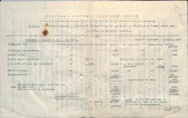
Document, Alex Cameron, "Chairman giving a comparison on cost estimates", 29/6/1907
Typed report by Mr Alex Cameron of the PMTT titled "Chairman giving a comparison between Original and Revised estimate of Noyes Bros in regard to proposed tramways" Orginal Estimate dated May 1906, revised June 1907. One of the principal savings was the purchase of power from the Electric Traction and Lighting Co instead of building their own Power Station. There were other changes to the estimates for track, alterations to sewers, water mains and drains, and rolling stock.Yields information about the cost of construction of the first stage of the PMTT in 1907.Document or report 5 foolscap sheets - carbon copytramways, tramcars, pmtt, costs, new tramways -
 Melbourne Tram Museum
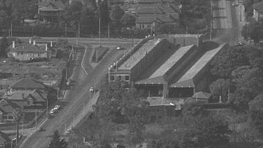
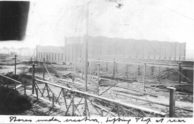
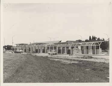
Photograph, Preston Workshops under construction, 17/6/1925
The photograph shows the construction of the Stores building at Preston workshops during 1925. In the middle foreground is a lifting jib crane. The Lifting Shop is the background. See also items 5526 and 7418 for other construction photographs.Yields information about the then new Preston Workshops being built.Photograph, black and white, on Kodak Velox paper with notes on the rear.On rear in black ink "17/6/25" tramways, preston workshops, construction, buildings -
 Melbourne Tram Museum
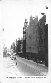
Postcard, Rose Stereograph Co, "Bourke Street Melbourne", c1935
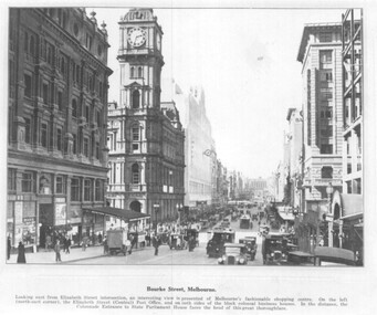
Rose Series postcard No. P 10532 titled "Bourke Street Melbourne", looking west from near Swanston Street. Has two cable trams in the far distance. The Myer Emporium building is shown along with the GPO. A building crane can be seen on the left side of the photograph where Diamond House is under construction for Dunklings which was completed in 1936.Yields information about Bourke Street c1935Postcard - printed real photograph with Rose Stereograph Co. name on the rear.trams, tramways, cable trams, bourke st -
 Melbourne Tram Museum
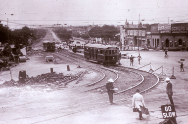
Slide, Melbourne & Metropolitan Tramways Board (MMTB), c1926
35mm colour slide TMSV copy slide of trackwork at St Kilda Junction, possibly soon after a change over to the new track in St Kilda Road. Has W 366 (St Kilda Beach) on the temporary or new track pending the construction of a road surface and the link to Wellington St. Photo may be from a photo held in the Public Records Office series. On the corner of Punt and St Kilda Road is s building advertising Schweppes Junction Motor service station."MP 30" in pencil on the side.trams, tramways, st kilda junction, trackwork, new tramways, w class, road works, tram 366 -
 Melbourne Tram Museum
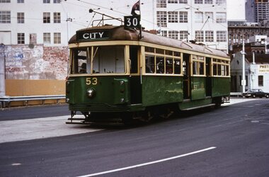
Slide, Tramway Museum Society of Victoria (TMSV), Tram VR 53 La Trobe St, c1974
Colour slide of VR class tram 53, route 30, westbound in La Trobe St on the bypass built to enable the construction of the Melbourne Central or Museum station between Dec 1973 and 1978 - see reference. The concrete looks relatively new in the photograph. The tram was originally built by the Victorian Railways for their St Kilda Brighton tramway in 1942. It is currently on display at the Melbourne Tram Museum. Many of the buildings in the background have since been demolished. The former Myer warehouse can be seen in the top right-hand corner of the photo.Yields information about VR tram 53 and Latrobe St c1974.Kodachrome colour slides, cardboard mount.Has "MP146" in pencil and stamped "Tramways Museum Society Victoria" on rear.tramways, vr class, tram 53, route 30, latrobe st -
 Melbourne Tram Museum
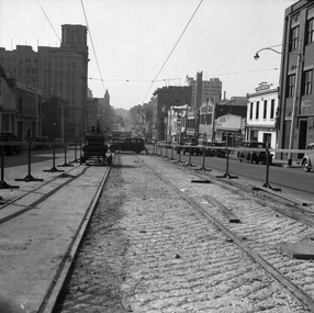
Negative - Set of 2, Possibly Geoff Grant, c1950
Set of two Black and white negatives of track construction in La Trobe St during 1950. .1 - Looking east from Queen St. Has the Argus building in the view. Both tracks have been constructed and the concrete foundation poured pending the top asphalt layer, a building selling Skoda cars, .2 - Looking west from Queen St with a tram crossing in the background in William St. Photo shoes the method of track construction - timber sleepers with the rail bolted to the sleeper. Pending concerting. In the background is The Mint and terrace houses on the left. There is a billboard for 1949 movie, "The Bribe". Photo not in Wal Jack Melbourne album.trams, tramways, la trobe st, track construction, trackwork, queen st -
 Melbourne Tram Museum
Photograph - Black & White Photograph/s, Tramway Museum Society of Victoria (TMSV), c1975
Black & White Photograph of a postcard made by the TMSV Sales consisting of two postcards showing cable trams in Elizabeth St, looking north from the Flinders St clock tower and Bourke St looking east from Swanston St. The first shows a bogie trailer being shunted. The second has the Myer store in the view. The first photo is dated between 1933 and 1935 based on the construction of the building next door to Hosies in 1933 and the closure of the cable lines in 1935. See 7-9 Elizabeth St - see https://s3.ap-southeast-2.amazonaws.com/hdp.au.prod.app.com-participate.files/8215/9494/3548/PROPERTY_103166_7TO9_ELIZABETH_ST.pdf - accessed 7-5-2022Has "TMSV 332 Flinders St Melbourne 3000" stamp on the rear.trams, tramways, cable trams, shunting, elizabeth st, bourke st, bogie cable trailers -
 Melbourne Tram Museum
Photograph - set of 3 Black and White photographs, Tramway Museum Society of Victoria (TMSV), c1975
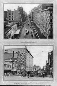
Series of three Black & White Photographs of a postcards made by the TMSV Sales of: .1 - Bourke St, looking east with the GPO in Elizabeth St in the view, along with many vehicular traffic - has the Myer building. c1920? .2 - Bourke St looking west from Swanston St prior to the construction of the Myer building. c1910. Has a number of horse drawn vehicles in the view and one motor car. Coles Book arcade on the south side. .3 - Similar to .1, but c1910 - has L Cohen & Co, Tailors and Outfitters. in the view. All views have cable trams in the view.trams, tramways, bourke st, elizabeth st, gpo, cable trams -
 Vision Australia
Photograph - Image, 1868 Time Capsule at St Kilda Road, 1985
In 1868, with the laying of the foundation stone, a time capsule was placed containing four newspapers of the day (Saturday 25 January, 1868 - The Age, The Argus, The Sun and The Telegraph: St Kilda, Prahran and South Yarra Guardian), the first Annual report of the Victorian Asylum and School for the Blind (1867), 11 coins from the Victorian regency and an illustration of the proposed building at St Kilda Road. An undated note also describes a piece of parchment in the time capsule, which contained a list of names of committee members and relevant people involved in the construction of the building, such as Crouch & Wilson; however no image of this has been located. In 1991, this time capsule was opened as part of 125 year celebrations and the contents were put on display. The capsule was the size of a house brick and buried underneath the foundation stone. It was made of metal and had to be sawn open to reveal the contents. These images are of the items found inside the time capsule. Additionally there are low res images of these items plus some photographs taken on the day: Brian Howe, Minister for Health, holds the time capsule whilst Trent Willard and Janice Johns, current RVIB students, stand by during the raising ceremony; Miss Molly Miller, the oldest surviving student, and Mr Percy Raufer, great grand nephew of Mary-Ann Raufer who was pupil number 6 and enrolled in the school in January 29th, 1866 look at the items found in the time capsule. In 2005 a new time capsule was buried, including an electronic copy of the 1867 report and drawing of St Kilda Road from the 1868 time capsule.Photographs and scans of items found inside the time capsuleroyal victorian institute for the blind, brian howe, trent willard, janice johns, molly miller, percy raufer, time capsule -
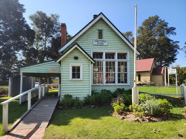 Old Gippstown
Building - School
2903 SUNNY CREEK formerly YARRAGON EAST. Sunny Creek State School, first called Yarragon East, was situated on Sunny Creek Road between Yarragon and Trafalgar and was opened in 1888. It was generally served by two teachers or a Head Teacher assisted by a Sewing Mistress. Edwin Mann taught there for 35 years, with his wife, Mrs Mann, as the Sewing Mistress for some years. [Extracted from Vision and Realisation: A Centenary History of State Education in Victoria, Vol. 3, 1973. This does not contain any details of the actual construction of the school, which is a typical Education Department building, and may date from later than 1888]High local historic significance, with some social significance: reunions of old students still held. (Dr Linda Young, Deakin University, significance assessment July 2009)Single-classroom State School. It is a rectangular-shaped timber building with weatherboard walls, timber frame and corrugated iron roof. An outside verandah is situated along the side of the building. Inside there is a small entry porch, a blackboard the length of the room (with fireplace) and a small store-room/cloak room. Built in 1888Has a name board above the front window that reads " SUNNY CREEK SCHOOL SS2903".school, sunny creek, old gippstown, west gippsland, gippsland, gippsland heritage park, goldfields, coal mines, victorian era, moe, historical village, education, sunny creek road, baw baw shire, yarragon east, latrobe valley, old gippsland heritage park, latrobe city council, board of education -
 Melbourne Tram Museum
Photograph - Black & White Photograph/s, The Met, c1985
Black and White Photograph of the construction of Latrobe University bus interchange c1985. The tram overhead can be seen in the far left of the photograph. The tram extension to Latrobe Uni opened in Jan. 1985. Shows the building work proceeding.On rear in ink "Bus Interchange under construction Latrobe Uni"trams, tramways, buses, la trobe university -
Glen Eira Historical Society
Album - Photograph Album, Beauville Estate Album, 2001
Originally labelled "Beauville Estate, Established 1936, Still Thriving 65 years on, 10th March 2001", the Beauville Estate Album contains colour photographs of houses in the Estate. They were taken around the time of the Beauville Estate’s 65th Heritage Celebration held on 10/03/2001 and donated to the Caulfield Historical Society shortly afterwards. Photographer Bev Baxter. Glen Eira’s Heritage Management Plan by Andrew Ward (1996) Vol 2 p78 states that by the end of 1934, the first 3 houses had been built in this housing estate.City of Glen Eira’s Heritage Management Plan Vol 2 p79 (p84 of the pdf version) – HO12 Beauville Estate and environs, Murrumbeena: The Beauville Historic Area is important at the State level as the first large housing estate undertaken by the AV Jennings Construction Co, later Jennings Group Limited, Victoria’s largest home builder. It is important also as a very early estate development incorporating a range of features other than houses and including made roads, shops and recreation facilities. In this respect it was the forerunner of the comprehensively planned housing estate of the post war era. The estate is distinguished by its aesthetic values, as is the earlier and comparable Hillcrest Estate, which are formed by a combination of restrained diversity in house styles, with the exception of no. 30 in the emerging International style, and by a landscaped garden environment.Colour photographs of house exteriors, as well as parks and tennis courts on the Beauville Estate. murrumbeena, houses, beauville avenue, architectural styles, 1930's, inter war style, a.v. jennings, av jennings, jennings, brick houses, beauville estate, murrumbeena road, lindsay avenue, gloucester court, dalny road, a v jennings construction co, beauville estate heritage area, glen eira city council, architectural features, plans, shops, residential development, tennis courts, housing estates, builders, building regulations, local government, commercial development, history, maps, photographs, commercial establishments, jennings group limited, land subdivision, gardens, beauville historic area, sir albert victor jennings -
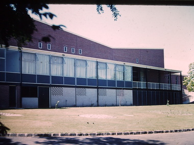
 Kew Historical Society Inc
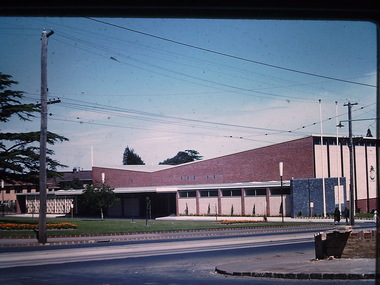
Photograph - Kew City Hall, Ron Setford, 1960
Ron Setford and his wife Grace Setford lived in Tanner Avenue, East Kew, from c.1946 to c.1995. A keen photographer, he recorded the changing face of Kew over a 20 year period. Apart from 30 photographs of built structures and places in Kew dating from 1960 and 1961, 145 of his 35mm colour slides chronicle the development of the Eastern Freeway through the Yarra Valley over a five year period from c.1972 to c.1977. This important collection was donated to the Society by his granddaughter in 2025.This collection of 175 35mm slides is of local and statewide significance, owing to its subject matter, particularly the major development of road transport infrastructure during the 1970s with the construction of the Eastern Freeway. The photographer also took care to annotate and date most of his slides which enable the researcher to pinpoint temporal and spatial locations.The Kew City Hall in Cotham Road, designed by Harold Bartlett, was intended as the initial phase in a scheme to develop an entire civic precinct. This was representative of a widely-held belief, of the immediate post-war era, that a district's civic centre should be precisely that – not just a single grand building for official use, but a dedicated precinct providing a range of community facilities as well as an administrative function. The Kew masterplan was later abandoned. The City Hall was designed to cater for public or official functions. Its interior had a small stage at one end for intimate theatrical productions, a larger stage at the other (with sunken orchestra pit) for musical performances, plus the most up-to-date equipment for live TV transmission."Kew Town Hall"ron setford, photographs -- kew (vic.) -- 1960s, kew town hall -
 Kew Historical Society Inc
Photograph - Country Roads Board and Denmark Street Baby Health Centre, Ron Setford, 1961
Ron Setford and his wife Grace Setford lived in Tanner Avenue, East Kew, from c.1946 to c.1995. A keen photographer, he recorded the changing face of Kew over a 20 year period. Apart from 30 photographs of built structures and places in Kew dating from 1960 and 1961, 145 of his 35mm colour slides chronicle the development of the Eastern Freeway through the Yarra Valley over a five year period from c.1972 to c.1977. This important collection was donated to the Society by his granddaughter in 2025.This collection of 175 35mm slides is of local and statewide significance, owing to its subject matter, particularly the major development of road transport infrastructure during the 1970s with the construction of the Eastern Freeway. The photographer also took care to annotate and date most of his slides which enable the researcher to pinpoint temporal and spatial locations.A photograph providing a visual contrast of the pre and post-World War II architectural styles of the Denmark Street Baby Health Centre and two of the Country Roads Board office buildings. Each was built on part of the land fronting the Kew branch line. In May 1939, the Railway Commissioners agreed to lease a site at the Kew Railway Station for a Baby Health Centre. The single-storey cream brick building was designed by Roland Chipperfield. The Country Roads Board (1913–83), later renamed VicRoads, transferred its headquarters from the Royal Exhibition Building to Kew in 1961, following the completion of two modernist eight-storey office towers in 1960. The VicRoads buildings were closed in 2024, and there is ongoing debate about what replaces them.Nilron setford, photographs -- kew (vic.) -- 1960s, country roads board, vicroads, denmark street -- kew (vic.), denmark street baby health centre -
 Kew Historical Society Inc
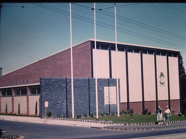
Photograph - Kew City Hall, Ron Setford, 1960
Ron Setford and his wife Grace Setford lived in Tanner Avenue, East Kew, from c.1946 to c.1995. A keen photographer, he recorded the changing face of Kew over a 20 year period. Apart from 30 photographs of built structures and places in Kew dating from 1960 and 1961, 145 of his 35mm colour slides chronicle the development of the Eastern Freeway through the Yarra Valley over a five year period from c.1972 to c.1977. This important collection was donated to the Society by his granddaughter in 2025.This collection of 175 35mm slides is of local and statewide significance, owing to its subject matter, particularly the major development of road transport infrastructure during the 1970s with the construction of the Eastern Freeway. The photographer also took care to annotate and date most of his slides which enable the researcher to pinpoint temporal and spatial locations.The Kew City Hall in Cotham Road, designed by Harold Bartlett, was intended as the initial phase in a scheme to develop an entire civic precinct. This was representative of a widely-held belief, of the immediate post-war era, that a district's civic centre should be precisely that – not just a single grand building for official use, but a dedicated precinct providing a range of community facilities as well as an administrative function. The Kew masterplan was later abandoned. The City Hall was designed to cater for public or official functions. Its interior had a small stage at one end for intimate theatrical productions, a larger stage at the other (with sunken orchestra pit) for musical performances, plus the most up-to-date equipment for live TV transmission.Nilron setford, photographs -- kew (vic.) -- 1960s, kew town hall -
 Kew Historical Society Inc
Photograph - Kew City Hall, Ron Setford, 1960
Ron Setford and his wife Grace Setford lived in Tanner Avenue, East Kew, from c.1946 to c.1995. A keen photographer, he recorded the changing face of Kew over a 20 year period. Apart from 30 photographs of built structures and places in Kew dating from 1960 and 1961, 145 of his 35mm colour slides chronicle the development of the Eastern Freeway through the Yarra Valley over a five year period from c.1972 to c.1977. This important collection was donated to the Society by his granddaughter in 2025.This collection of 175 35mm slides is of local and statewide significance, owing to its subject matter, particularly the major development of road transport infrastructure during the 1970s with the construction of the Eastern Freeway. The photographer also took care to annotate and date most of his slides which enable the researcher to pinpoint temporal and spatial locations.The Kew City Hall in Cotham Road, designed by Harold Bartlett, was intended as the initial phase in a scheme to develop an entire civic precinct. This was representative of a widely-held belief, of the immediate post-war era, that a district's civic centre should be precisely that – not just a single grand building for official use, but a dedicated precinct providing a range of community facilities as well as an administrative function. The Kew masterplan was later abandoned. The City Hall was designed to cater for public or official functions. Its interior had a small stage at one end for intimate theatrical productions, a larger stage at the other (with sunken orchestra pit) for musical performances, plus the most up-to-date equipment for live TV transmission.Nilron setford, photographs -- kew (vic.) -- 1960s, kew town hall -
 Eltham District Historical Society Inc
Audio - Audio Compact Cassette Tape, Harry Gilham, Audio Recording; Eltham Library History presented by Harry Gilham, 1994
The new Eltham Library was opened 22 May 1994 and celebrates its 30th anniversay in 2024. This audio recording, presented by Harry Gilham, President of Eltham District Historical Society at the time of the opening is a summarised history of the Eltham Library service to 1994. Eltham Library Service 1930s - 1994 Originally collated by Harry Gilham, President, Eltham District Historical Society Inc (1993-2009) (edited 2022) In the Eltham township area, in the early 1930s, library books for adults were available from E J Andrew's newsagency in Main Road. In the newsagency come haberdashery, some shelves were set aside for a lending library of adults' books. In 1935, Mr & Mrs JC Rains purchased the newsagency and continued the lending service until the late 1940s. At this time the business was extended from haberdashery to sell ladies' and men's clothing. The library section was discontinued. In the 1930s a mobile book library was also run by a Mr Foster of Bible Street, Eltham. In the 1950s adult books were available from racks in the foyer of the Eltham Shire Offices which was then located beside the Eltham Hall on the comer of Arthur Street and Main Road. In the early 1950s a referendum of ratepayers was called to seek public opinion on the issue of raising money for a public library for which the rates would have to be increased - the motion was defeated. On 11 November 1965 Eltham Shire Council, in conjunction with the City of Heidelberg and the Shire of Diamond Valley, met to form the Heidelberg Regional Library Service. Eltham was represented by Councillors Charis Pelling and John Lewis. The first library service for the Shire of Eltham from this group came in the shape of a bookmobile van which had, amongst others, a central stopover near the Shillinglaw trees outside the newly opened Shire offices at 895 Main Road, the original site of Shillinglaw Cottage and the former Shillinglaw farm. Present-day Wingrove Park was another stopover and the many recorded requests for this service can be read as denoting the areas of population or gathering points at that period throughout the Shire. 1968 saw the Shire convert the ‘Brinkkotter’ house in Dudley Street to house both adult and children's books. This library was originally staffed from the City of Heidelberg Library and records of committee meetings range from borrowing Heidelberg's old library shelving to trying to increase the Government's subsidy to a dollar for dollar basis. Book loans in the period 1966-67 totalled 30,400 and the following year ran to 52,113. With 2 books plus 1 paperback the limit per person, it was overcrowded and unable to house the range of other services which had become common library stock. Planning to extend the Shire Offices by the addition of the south wing was an opportunity to re-house the Shire's Library. The opening of the library in the extension was carried out on 17th August 1971 by the Hon R J Hamer ED, MP, Chief Secretary of Victoria. Cr Geoffrey Dreverman officiated as the Shire President. The Heidelberg Regional Library Service continued until September 1985 when it disbanded. On 21 November 1985 the Yarra Plenty Regional Library Service was established. At that time Eltham was represented by Councillors Mary Grant and Robert Manuell. By 1987, over-crowding of the Eltham Library and an inability to house the range of other services yet again rose to prominence. At a Council meeting held on 1 June 1987, the Councillors supported a resolution which threatened to close the library on 30 September 1987. Council's frustration arose from yet another re-run of the annual State Government versus Council Library funding and records show first arose in Eltham Council in 1967 with the Government of 1he day. After prolonged public anger and petitions the motion to close the library was rescinded in August 1987. Council, considering the community's concern, set up a ‘Library Review Working Party’ which a year later became the Library Occasional Committee with direct access to Council. This Committee investigated the workings of the 386 square metre library and found inadequate space for storage and display, lack of equipment, out-of-date furniture together with an increasing patronage which resulted in queues of borrowers becoming longer no matter when the library was open. Community consultation took the form of 1,000 questionnaires sent to users and non-users along with noticeboard reminders of what was planned. Council developed a strategy to set aside capital funds from 1988 on an annual basis so that preliminary planning and consultative expenses could be met, and construction could be completed early 1997. The Committee visited metropolitan libraries which were catering for a similar population as was projected for Eltham. Australia-wide Federal Government funding grants under the Local Capital Works Program became available from October 1992 for community projects endorsed by local Councils. The Eltham Council submitted a proposal, based on library findings and requirements accumulated by the Library Occasional Committee, to the Federal Grants Committee to build a new Eltham Library. The Federal Grants Committee supported the funding request allowing commencement of the library project three years earlier than planned. With finance finalised, the Council set up its Eltham Library Re-development Special Committee which was given the task of overseeing what could be the last major expansion of the Shire's Library Service as Eltham's population nears its projected maximum. The new library was designed by Gregory Burgess and Peter Ryan of Gregory Burgess Pty Ltd. Construction of the library commenced in 1993 and was officially opened May 22nd, 1994. The library building was designed to reflect its parkland setting. External features include: the roof which includes interesting aspects when viewed from Main Road; verandahs which provide ramp access and give a sheltered entrance to the building; walls which feature locally made mudbricks, conventional bricks and copper panels; and space for an outdoor courtyard/reading area which will be developed later. Internally there are several features. The building includes a foyer with a fireplace suitable for displays including artwork, a community multi-purpose room suitable for meetings or functions and an outdoor cafeteria. The ceilings are lined with Victorian Ash. The shapes for the ceiling give a free-flowing form to the building. Brush Box has been used for the circulation and information desks. The tree trunk columns are Grey lronbark from New South Wales. Arches and various-shaped windows add interest to the internal structure. The carpet design reflects the Eltham environment and compliments the natural colours and timbers used in the building. Tiles by artist Felix Bosari feature in the building and additional art by local artists added externally and internally to the building. Since 1994 the library has undergone a major extension to cater for children’s services and others. See also EDHS_02111Digital file only recorded from Audio Cassette tape on loan Converted to MP3 file; 11.1MB, 0:08:49eltham library, opening, harry gilham, harry gilham collection, 1994, audio cassette, audio recording -
Glen Eira Historical Society
Document - TOURS
... Building construction ‘Burreel’ Kooyong Road Burreel Avenue Francis ...There are two copies of the Discover Caulfield guide produced by the Caulfield Historical Society. One from 1982 which contains twelve pages, seven of which are typed and the last five a continuation of the guide added later, hand-written. The other is a modern typed version of the same document, including information at the end that "Notes prepared by R. Ballantyne, 25th July, 1982, updated by Betty Snowball, 1992 and Gladys Vallati 4th August, 1995". They both detail a pictorial tours of the mansions and gardens in the City of Caulfield, similar but not identical.caulfield, mansions, gardens, homes, ‘lirrewa’, lirrewa grove, caulfield city hall, smith sydney, ‘halstead’, bambra road, halstead road, caulfield historical society, messrs. upton and smith, civic establishments, dickson james dr., houses, national trust, st. stephen’s church, balaclava road, gothic (revival) architecture, messrs. haddon and henderson, st. aloysius, archbishop of melbourne mannix dr., caulfield park, hawthorn road, inkerman road, kambrook road, paddy’s swamp, cannizzo philip, caulfield city council, trams, orrong road, grimwade house, ‘harleston’, grimwade frederick sheppard, primary schools, caulfield art centre, ‘stanmark’, art galleries, ‘craigellachie’, person william, pearson eliza, francis newton mr., greenmeadows gardens, milburn grove, greenmeadows house, lempriere john, mayors, ‘glenfern’, boyd john captain, boyd martin, ‘myoora’, alma road, ‘bagatelle’, christian thomas, henderson anketell, flats, building construction, ‘burreel’, kooyong road, burreel avenue, francis john, stephen sidney, allan george l., ‘royston’, renwick s. mrs., sargood frederick sir., ‘glen eira’, ricketson henry, caulfield hospital, royal southern memorial hospital, caulfield general medical centre, ‘ripponlea’, reed and barnes, architects, towers, rippon emma, rippon thomas, guilfoyle william, employees, ‘the village houses’, regent street, st. george’s road, cottages, bent thomas sir., jones louisa mrs., nathan benjamin, ‘anselm’, glenferrie street, queen anne style, haddon robert, historical buildings, princes’ park, ‘glenmore’, watts thomas, more hugh, glenhuntly road, gates, villas, ‘hopetoun’, hopetoun street, webb charles, hopetoun hospital, harleston park, allison street, langdon montague, langdon harry joseph, ‘tarqua’, ‘labassa’, manor grove, koch john, robertson a. w., wagner john, ‘ontario’, trinity congregational church, grange road, glen huntly, churches, greek orthodox church, ‘fairfield hall’, north road, younger james, glenhuntly post office, smith alfred, smith anne, methodist church, ‘lambros the cobbler’, railways, ballantyne r., snowball betty, kahlyn private hospital, ‘kynaston’, st. mary’s jubilee school, festivals and celebrations, st. mary’s anglican church, church of england, bishop moorhouse, joynt donoman, elsternwick post office, elsternwick, elsternwick bowling club, elsternwick rsl, caulfield grammar school, davis henry rev., selwyn street, elsternwick railway station, glen eira road, barnett r. j. rev., tudor court, world war 1914-1918, ‘fairhaven’, hope george, caulfield library, plaques, cannons, ‘janvec joinery’, parkside street, ‘parkside court’, clarence street, ‘streetscene’, grange road, greenhouses, vallati gladys -
Glen Eira Historical Society
Document - Grange Road, 77, Glen Huntly
This file contains 4 items about the purchase and construction of this property: 1/ The original contract of sale of land dated 25/09/1936 for Gertrude & Hulbert Gorrie situated on the corner of Grange and Neerim Road. 2/ The original typed building agreement dated 25/09/1936 between the contractor Ernest F Barnard and the purchasers Mr & Mrs Hulbert Gorrie. 3/ The original blueprint plan of a brick villa at the corner of Grange & Neerim Road for Mr & Mrs Hulbert Gorrie. Dated 25/09/1936. 4/ The original specification for the dwelling on the corner of Grange & Neerim Road, Glen Huntly for Mrs Gertrude Gorrie & Mr Hulbert Hopetoun Gorrie by builder Ernest F Barnard.barnard ernest f, gorrie gertrude, gorrie hulbert hopetoun, hobart john bertram, coorigil road, carnegie, holloway st, ormond, chemists, parish of prahran, caulfield county of bourke, building agreement, brick houses, builders, plans, architectural drawings, grange road, glen huntly, holloway street, ormond, emma street, grange road, neerim road, gorrie h.h, gorrie gertrude, gorrie hulbert h, legal documents, barnard ernest franklin, e. j. & h. amos, hintons nursery, real estate agents, murrumbeena, caulfield -
![Photograph - Construction of the F19 [Eastern Freeway], Ron Setford, May 1976](/media/collectors/550653872162f11fb04854aa/items/68287b0064071e7c58e662fc/item-media/68287b2864071e7c58e664ce/item-fit-380x285.jpg) Kew Historical Society Inc
Kew Historical Society IncPhotograph - Construction of the F19 [Eastern Freeway], Ron Setford, May 1976
Ron Setford and his wife Grace Setford lived in Tanner Avenue, East Kew, from c.1946 to c.1995. A keen photographer, he recorded the changing face of Kew over a 20 year period. Apart from 30 photographs of built structures and places in Kew dating from 1960 and 1961, 145 of his 35mm colour slides chronicle the development of the F19 (later renamed Eastern) Freeway through the Yarra Valley in Kew over a five year period from c.1972 to c.1977. This important collection was donated to the Society by his granddaughter in 2025.This collection of 175 35mm slides is of local and statewide significance, owing to its subject matter, particularly the major development of road transport infrastructure during the 1970s with the construction of the Eastern Freeway. The photographer also took care to annotate and date most of his slides which enable the researcher to pinpoint temporal and spatial locations."Conservation & building buffer wall behind housing"ron setford, eastern freeway, f19 freeway -
![Photograph - Construction of the F19 [Eastern Freeway], Ron Setford, May 1976](/media/collectors/550653872162f11fb04854aa/items/68287a1764071e7c58e65e10/item-media/68287a3864071e7c58e65fca/item-fit-380x285.jpg) Kew Historical Society Inc
Kew Historical Society IncPhotograph - Construction of the F19 [Eastern Freeway], Ron Setford, May 1976
Ron Setford and his wife Grace Setford lived in Tanner Avenue, East Kew, from c.1946 to c.1995. A keen photographer, he recorded the changing face of Kew over a 20 year period. Apart from 30 photographs of built structures and places in Kew dating from 1960 and 1961, 145 of his 35mm colour slides chronicle the development of the F19 (later renamed Eastern) Freeway through the Yarra Valley in Kew over a five year period from c.1972 to c.1977. This important collection was donated to the Society by his granddaughter in 2025.This collection of 175 35mm slides is of local and statewide significance, owing to its subject matter, particularly the major development of road transport infrastructure during the 1970s with the construction of the Eastern Freeway. The photographer also took care to annotate and date most of his slides which enable the researcher to pinpoint temporal and spatial locations."Building buffer wall to housing"ron setford, eastern freeway, f19 freeway -
Bialik College
Document (collection) - Papers of architect Ron Unger
redevelopment, buildings, construction, auburn rd, shakespeare grove, architecture, planningredevelopment, buildings, construction, auburn rd, shakespeare grove, architecture, planning -
Bialik College
Document (Sub-series) - Architect Ron Unger's papers relating to Auburn Road campus
development, construction, buildings, 1980sdevelopment, construction, buildings, 1980s -
Bialik College
Documents, Construction of building on the Auburn Road campus, c. 1980s, 1980s
Plans for the construction of a building on the Auburn Road campus, c. 1980s. Please contact [email protected] to request access to this record.development -
 Eltham District Historical Society Inc
Document - Property Binder, 616 Main Road, Eltham; Plum Cottage
Plum Cottage is covered by Heritage Overelay HO256 in the Nillumbuk Planning Scheme This two-lot land holding was created as a subdivision and sold to Charles Stuart McNeil by May 1955. Sometime in the period 1955-1960, the builder-designer, John Harcourt had created a pise house on the site, straddling the two subdivision lots. The designer, John M. Harcourt was a pioneer builder in pise-de-terre and mudbrick in the Eltham Shire, Eltham being synonymous with alternative lifestyles and building practises until the onset of suburbia in the late 20th and early 21st centuries. This hipped-roof house is set high above Main Road on a V-shape plan characteristic of the Arts & Crafts style, with rammed earth or pise walls, timber joinery and a cement tiled roof. The V shape plan was used by important English and Eltham Arts & Crafts designers. The use of natural materials such as stone and timber construction is an essential part of the Arts & Crafts style and Harcourt’s work. So too is the application of the style on both the exterior and interior of the house as a holistic concept. The house adjoins the Lim Joon adobe house built and designed by Alistair Knox in the same era (HO119), thus forming a distinctive pair, both using an uncommon plan form. This house was identified in the Shire of Shire of Eltham Heritage 1992 as contributory to the Eltham Gateway Conservation Area, then proposed as an urban conservation area (now Heritage Overlay Area). Land Ownership Emily Jane Smith of 12 Woodside Street Fitzroy owned Crown Allotments 1 & 2 Sections 14, 27 by August 1918, selling to William Henry Smith of 12 Woodside Street, Nth Fitzroy May 1921. (John) James Isherwood of Main Road, Eltham owned the property by 1928 (the year of his death) with the beneficiary of his estate and next owner of this site being his widow, Minnie Maria Isherwood of Cemetery Road, Eltham. His holding in Main Road included parts of what was described in rate records as allotments1 & 2 Section E6. In the late 1930s, early 1940s her son Alfred John Isherwood was also rated for the land around this site, with the rated nett annual value varying between £2 and £5. Alfred Isherwood also lived at Main Road, Eltham with his wife Ellen: her early death at the age of 24 was reported in the Argus of 1923. Part of the Isherwood land was divided off and sold to Charles Stuart McNeil by May1955. Sometime in the period 1955-1960, the builder-designer, John Harcourt had created a pise house on the site, straddling the two subdivision lots. The house is visible on an aerial photograph from 1960s. Reputedly the house was called Plum Cottage and erected for Harcourt’s mother-in-law. A garage was added in 1959. Charles McNeil died in1971 aged 87: he was the son of Don McNeil and Margaret Arkell. Available rate records from the construction era start in the of the 1970s (1972-3) and list Mr H.C. & M/S A.V. Charity at 616 Main Road Eltham of this property with a nett annual value of $740. More recent valuer's data describes the property as lots 1 & 2 LP25668, located in the Central Riding of Eltham Shire, owned by Ann Valerie Charity and later, in 1990, by the Chincarini family. Building Description This hipped roof 11 .5 square house is set high above Main Road on a characteristic-shape plan and has rammed earth or pise walls, timber joinery and a cement tiled roof. The V-shape plan was used by Important designers such as C.F.A. Voysey (UK) who interpreted medieval domestic architecture as part of the Arts & Crafts style of the late 19th and early 20th centuries. The pise walls are covered with a textured render while the cement roofing tiles are also seen in the Harcourt Hill examples. Reputedly the ceiling joists are of a deep section and span long lengths with no need for hanging beams in the roof space. The ceilings are low and panelled in main rooms with apparently Caneite soft board infill panels between the exposed ceiling beams. These are painted white but may have been stained at one time. The focus of the house is the large living area with its vast random stone fireplace. Significance Plum Cottage is significant to the locality of Eltham because: Historically: • Plum Cottage is closely associated with the important historical theme of earth construction evident in Eltham and elsewhere in the Shire since theear1y Arts & Crafts inspired creations at Penleigh Boyd's The Robins (1912, HO101) and those at Montsalvat (1934-, HO82) but more prominent from the Second War period when earth building in Eltham was promoted in national periodicals as an alternative building method that avoided the building materials shortages of that era; • The choice of the earth building technique also expresses the theme of refuge or alternative living, synonymous with Eltham in the early to mid 20th century; • as a good example of domestic architecture from John Harcourt who was the first major post Second War figure in an important phase of Eltham’s earth building development, using his characteristic Old English or Arts& Crafts style that relies in this case on the pise wall construction, pitched roof forms, exposed ceiling joists, half timbering, random stonework, and panelled internal wall finishes. Architecturally: • Plum Cottage's pise wall construction is uncommon among the early earth-walled structures in the Shire, that are mainly of adobe or mud brick, and as a building material is uncommon among the Shire’s suburban dwellings generally which are clad typically with either fired clay bricks or timber boarding. Aesthetically: • Plum Cottage is a good and well preserved example of a modern Old English or Arts & Crafts style earth-walled building in the Shire • For the proximity of the significant Lim Joon adobe house designed by Alistair Knox adjoining to the north, providing a distinctive earth wall house pair, with uncommon plan forms. Reference Heritage Assessment of Plum Cottage, 616 Main Road, Eltham; Graeme Butler & Associates 2010main road, eltham, property, houses, (john) james isherwood, alfred john isherwood, ann valerie charity, arts and crafts style, charles stuart mcneil, chincarini family, eltham gateway zone, emily jane smith, h.c. charity, heritage assessment, john harcourt, john m. harcourt, lim joon house, main road eltham, minnie maria isherwood, pise construction, plum cottage -
 Eltham District Historical Society Inc
Document - Property Binder, 931 Main Road, Eltham
Present day location of Nongkhai Thai Eltham restaurant Formerly the location of: Luther Haleys Bakery and General Store (Sep 1902-1917) - Hayley built this store, which was the first store erected in the present-day Eltham shopping district Hannah Lloyd's General Store (1917-c.Feb 1920) Various owners Staff's General Store (c.1939-Feb 1965) then demolished Ray Staff Eltham Big Star Food Centre (c.1965-1967) Eltham Big Star Food Centre (Staffs new building c.1965-1967) A Country Heritage Furniture and Homewares (?-2006) Newspaper advertisement: Leader Associated Newspapers, 100 Years of News Special Edition, August 27, 1997, p6; A Country Heritage Newspaper advertisement: Diamond Valley Leader, 4 September 2006, Closing Down Sale, A Country Heritage In February 1965, Staffs Railway Store, the oldest business premises in the Eltham shopping district was demolished. Formerly a self-service grocery, restaurant and electrical repair shop, the building for many years housed Eltham’s only ‘family’ grocer and feed store. Earlier it had appeared to have been the town’s bakery. The building had been purchased in late March 1939 by Mr Eric N. Staff. At the time of E.N. Staff’s purchase there were huge bakers’ ovens located at the rear and the building also had a well and four toilets for employees. When the ‘pictures’ came to Eltham with the opening of the Eltham Public Hall across the road in 1941, Mr E.N. Staff extended the business and opened a milk bar and sweet shop. Further extensions re-established the tea rooms of days gone by. Mr E.N. Staff conducted business for about 15 years before handing over the reins to his son, Ray Staff. When his son Ray took over, the milk bar and tea rooms were closed for several years but the milk bar and was later re-opened and subsequently became a greengrocers and later again, a restaurant. The tea rooms section was converted to an electrical repair shop about 1955. Electoral Roll records for 1967 record Raymond Charles Staff at 929 Main Road, Eltham, grocer, and in 1968 at Lot 4, Hillcrest Avenue, Eltham, taxi truck operator. Staff’s store appears to have occupied 929-933 Main Road and the Eltham Big Star Food Centre was centred around 931 Main Road. It would appear that Ray continued to run the business for approximately two years after the original store was demolished and a new supermarket was built. Today, 931 Main Road is the Nongkhai Thai Restaurant and is precisely where the original Staffs store stood. Even though the facade has been modified at eye level with new larger windows, the upper facade is identical to that of the new Eltham Big Star Food Centre of 1965/66. But how did the original building, the oldest premises in the 1965 era shopping centre come about? On August 12th, 1902 at the Eltham Courthouse, appearing before T. Smallman, Esq,. Police Magistrate, and Messrs. W. Duncan and W.J. Taylor, Justices of the Peace is Luther Haley, baker. Wilfred Henry Johnston, by his agent Stanley Ernest Elder had applied for a warrant of ejectment under the Landlord and Tenant Act 1890 against Luther Haley from the bakery premises at the corner of Main Road and York Street. From the evidence presented we learn that Mrs Burgoyne of Eltham had purchased the property some months earlier from Mr Johnston, which consisted of a store and bakery establishment at Eltham occupied by Mr. Luther Haley, and whose lease expired some little time back, and up to the present time, Mr. Haley was not prepared to leave. He informed the court that he is unable to secure at Eltham a suitable house in which to carry on his business, but was building a place near the railway station which he expected to be done in about three weeks time, and he is then prepared to give up possession of the premises he now occupies. Mr Smallman informed the defendant, Luther Haley, that he will have to quit the premises in three weeks from the present date, and that a warrant of ejectment would be issued. However he also informed Mr Haley that he would order the warrant to lie in the office for three weeks from that date. The premises under construction referred to by Luther Haley in court were situated on the western side of Main Road, near the railway station slightly opposite present-day Arthur Street. It was opened around September 1902 as a General Store, Bakery and Tea Rooms. This was the original building in the present-day shopping precinct. At the time the only thing nearby was the railway station. Luther Haley’s business appeared to prosper and he would have catered to not only the locals abut also day visitors by train on Sundays coming up from Melbourne, offering fresh baked produce, tea rooms and summer drinks. The fields across Main Road running between present day Arthur Street and Luck Street were known as Haley’s Paddock and at times were used for community festivities and picnics. A newspaper report on the annual State schools picnic held at Haley’s Paddock on March 11, 1904 described it as “quite close to the railway station, and is quite capable of holding comfortably 10,000 people. With its ample shade and hilly surroundings, it is an ideal place for any gathering.” Luther Haley successfully ran his general store, bakery and tea rooms until 1917 when he and his family departed the district and moved to Westgarth Street in Northcote where he changed careers and became a publisher. It was then taken over by Hannah Lloyd and became known as Lloyd’s Railway General Store from 1917 to 1920. From then it had a succession of owners, one as short as two months until March 31, 1939 when the Grocery Business formerly carried on by Mr. T.K. White of Eltham for the previous eight years was purchased by Mr Eric N. Staff of Research and became known as E.N. Staff’s Railway Store. The ownership timeline for the store is as follows: Luther Haley Sep 1902-1917 Hannah Lloyd 1917-c.Feb 1920 Messrs J.R. & N.E. Lee 1920-Sep 1922 A. & E. Copeland Sep 1922-Sep 1925 Mr Price Sep 1925-Nov 1925 Mr Warren Nov 1925?-Nov 1926 A.W.J. Edwards Nov 1926-1931 T.K. White 1931-Mar 1939 Eric Staff Apr 1939-c.1954 Ray Staff c.1954-Feb 1965 then demolished Ray Staff Eltham Big Star Food Centre c.1965-1967 THROWBACKTHURSDAY: ELTHAM BIG STAR FOOD CENTRE, MAIN ROAD, 1966 https://elthamhistory.wordpress.com/2020/04/16/throwbackthursday-eltham-big-star-food-centre-main-road-1966/eltham, businesses, a country heritage, property, shops, main road eltham, a. copeland, a.w.j. edwards, big star food centre, e. copeland, eric staff, general store, hannah lloyd, j.r. lee, lloyd's general store, luther haley, n.e. lee, price, ray staff, staffs general store, supermarket, t.k. white