Showing 777 items
matching the corner store
-
 Ballarat Tramway Museum
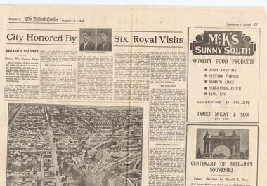
Newspaper, The Courier Ballarat, City Honored by six Royal Visits, Mar. 1938
Yields information about Ballarat and its locations or environs late 1938.Pages 11,12, 19 and 20 of the centenary of settlement in the Ballarat district by the Ballarat Courier - March 1938. See also items 186, 198 and 199. Page 11 Royal visits, banking in Ballarat, photos - NW section of Ballarat, railway station in foreground. Ads for J.McKay and Son, Roy Reeds (Men's store) and Ballarat Gas Co. Also photo of "The Corner" in Sturt St. - old Mining Exchange. Page 12 - full page ad for Morseheads, women's store. Page 19 - articles - Ballarat Lighting and Power, ESCo, SEC, electric trams. photos of the Arch of Victory, first electric tram, Lake Wendouree. Advertisements for Austin Spears (cycles), McDougall and Chisholm (drapers), W.E. Longhurst (bread) and the ES&A bank. Also article on South St. Society - music and elocution. Page 20 - articles - Ballarat Gas Co., horse and electric trams, agriculture in district and Ballarat's war record (WWI). Photos of work at Gong Gong Reservoir and Committeemen of the Ballarat Horticultural Society - 1859 to 1885. Ads for Ballarat College, Clarendon, Queens (girls) and Ballarat Grammar schools, Ern Craig Motors (Vauxhall) and Snows men's wear. Record reviewed and images of pages added 7-9-2013 and 10-9-2013trams, tramways, ballarat electricity, centenary, banking, transport, trams, esco -
 Ballarat Tramway Museum
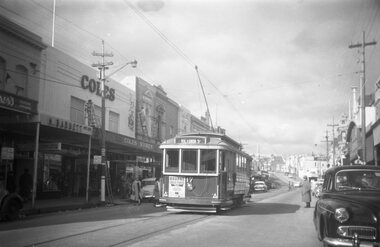
Photograph - Black and White photocopy, Travis Jeffrey, 1959 or 1960
Negative No. N378 and black and white print made by a laser printer (stored in folder) of Ballarat No. 17 outbound in Bridge St. for Victoria St. in 1959 or 1960. Photo taken after tram has passed. Has Bourne liquid plastic ad on rear of tram. Two small triangles in corners. Car number over headlight. Photographed by tram stop, with Coles store in background. A few parked cars and some cars on the streets. Date of photo on folder - 11/6/1960. Note: Reg Item 858 of Ron Fluck of 31/12/58 shows tram number to the side of the headlight while Wal Jack (Reg. Item 396) of 23/1/61 shows tram fitted with dash canopy lights. Large print of this photo made for display 1995c. Item updated when negative added to collection - 11/5/2003. Hi -Res Image available for this photo, on CD ex Harris House of Photography see Reg Item - 4457. Original negative rescanned 24/5/2020 and image file updated. Paper print of original photo in folder 73.Paper folder that contained the negative had "NR34A" in red ink, "BA5" in pencil, date stamp of "11 Jun 1960" on front, and on rear date stamps "26 Sep 1962" and "6 Oct 1962".trams, tramways, ballarat, coles, victoria st., bridge st., tram 17 -
 Ballarat Tramway Museum
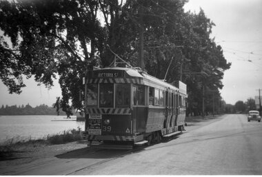
Photograph - Black and White photocopy, Travis Jeffrey, 1961
Negative No. N387 and black and white print made by a laser printer (stored in folder) of Ballarat No. 39 passing depot junction, in 1961. Tram fitted with lights and small white stripe. Small triangles in corners of front dash. Ad for 60/40 dancing at Civil hall on front of tram. Showing Victoria Street destination. Lake in background, no other vehicles. Photo by Travis Jeffrey, who advised could be Dave Kellett driving. Date of photo on folder 5/9/1960. Date of photo could be incorrect, due to fitting of lights taking place late 1960. Large print of this photo made for display 1995c. Item updated when negative added to collection - 1/6/2003. Original negative rescanned 24/5/2020 and image file updated. Paper print of original photo in folder 73.Paper folder that contained the negative had "NR40A" in red ink, "BA14" in pencil, date stamp of "5 Sep 1960" on front, and on rear date stamps "26 Sep 1962" and "6 Oct 1962".trams, tramways, ballarat, wendouree parade, tram 39 -
 Kew Historical Society Inc
Archive (Sub-series) - Subject File, CARRUCAN Pte. Thomas M. & Family, 1958
Various partiesReference, Research, InformationSecondary Values (KHS Imposed Order)Subject file including information relevant to the Carrucans of Kew. The Carrucans were fuel merchants, selling wood, coal and coke) on the corner of Highbury Grove and High Street, Kew (Vic) for over 60 years. The file contains two loosely bound archive files written by Francis William Lynch, one on Pte Thomas Michael Carrucan (1892-1951), and the other on the Carrucan family generally. The general history was presented to the Society in 2011 by Kathleen Murphy.carrucan family - kew (vic), pte thomas m carrucancarrucan family - kew (vic), pte thomas m carrucan -
Kew Historical Society Inc
Archive (Sub-series) - Subject File, Fernhurst (Kew), 1973
Various partiesReference, Research, InformationSecondary Values (KHS Imposed Order)Subject file containing research related to George Wharton and his house Fernhurst, originally situated on the corner of Princess Street and Studley Park Road, but later subdivided. The house was in the 20th century converted into flats and later bought by the Catholic Church, who established St Paul’s School for the Blind on the site. The situation was complicated as the Church also bought the neighbouring Neama and Mandalay. Villa Maria and St Paul’s School currently occupy the site. Part of the site was later subdivided to create Elphinstone Court. The file contains photocopied extracts from histories and detailed research and correspondence between the School, the Kew Historical Society, the National Trust of Victoria, and the Historic Buildings Preservation Council relating to both Neama and Fernhurst. There is a reference in a letter from St Paul’s inviting the Society to collect artefacts from the site. There are no known current items in the collection relating to the collection of these. kew (vic) - history, victorian architects - george wharton, fernhurst (kew), st paul’s school for the blindkew (vic) - history, victorian architects - george wharton, fernhurst (kew), st paul’s school for the blind -
Kew Historical Society Inc
Archive (Sub-series) - Subject File, Foster Parents Plan (Kew), 1980
Various partiesReference, Research, InformationSecondary Values (KHS Imposed Order)Single item subject file, with a newspaper article/clipping stating that the organisation Foster Parents Plan of Australia (PLAN) was located on the corner of Cotham and Highbury Grove. The organisation was located in what had been the Kew Presbyterian Church.kew (vic) - history, social welfare - kew (vic), child services - kew (vic)kew (vic) - history, social welfare - kew (vic), child services - kew (vic) -
Kew Historical Society Inc
Archive (Sub-series) - Subject File, Kew Historical Society et al, GARDNER, Charles, 1958
Various partiesReference, Research, InformationSecondary Values (KHS Imposed Order)Notes compiled by Miss Daisy Gardner in November 1958 and provided to the Society. The 5-page handwritten document describes Charles Gardener and his family who migrated to Australia in 1884. They moved to Kew and built a two-storey house, ‘Bassem’ on the corner of Cotham Road and Atkins Street. He and his son Edgar were managers of Messrs. Cassell & Co Ltd, publishers. A descendant, W. Gardener was an architect who built the Gardeners a house on the corner of Cotham Road and Edgevale Street in which WHS Dickinson once lived. There is some confusion in the document about the exact location of the house. On the document there is a later annotation/correction by E.L. Frazer. kew historical society - archives, charles gardner, mayors of kewkew historical society - archives, charles gardner, mayors of kew -
Kew Historical Society Inc
Archive (Sub-series) - Subject File, Kew Historical Society, 'Goldthorns' (Houses, Kew), 1958
Various partiesReference, Research, InformationSecondary Values (KHS Imposed Order)Subject file containing Executor's Auction, Sunday 24th October 1931, "Goldthorns", Normanby Road, Corner of Argyle Road, Kew’ - Four page flyer advertising the sale of Goldthorns in Normanby Road, Kew in October 1931. The flyer contains a photograph of the front of the house, a list of its rooms, a site plan (including possible subdivisions) and a photo of the extensive rear garden.goldthorns - normanby road - kew (vic),, goldthorns estate, mansion - kew (vic), gardens - kew (vic), griffiths family, subdivisions - kew (vic)goldthorns - normanby road - kew (vic),, goldthorns estate, mansion - kew (vic), gardens - kew (vic), griffiths family, subdivisions - kew (vic) -
Kew Historical Society Inc
Archive (series) - Subject File, 'Bella Vista', (aka 'Malinda')
Kew Historical SocietySince its foundation in 1958, members of the Kew Historical Society have been compiling and storing information about subjects relating to the history of Kew and its environs, of which this file is an example.Secondary values'Bella Vista' was a large Federation house built in 1902 which occupied the eastern corner of Thomas Street and Cotham Road. The house was built for Abel Hoadley who died in 1918. In 1937 Augustus Beker opened the property as a guest house named 'Malinda' Guest House. This closed in 1940. In 1941, the land was subdivided into four lots. During the 1940s, Fr. Maas opened a hostel for Dutch Catholic immigrants in the house. The house has now been demolished. The subject file contains an auction notice for the sale of Malinda in 1941 along with correspondence from 2016 detailing background information, a timeline of the demolition of th those, the name of the original owner, and other uses of the house's name.malinda, bella vista, cotham road, fr maas, abel hoadley, anthony heinemannmalinda, bella vista, cotham road, fr maas, abel hoadley, anthony heinemann -
 Kew Historical Society Inc
Plan - Subdivision Plan, Shop Sites, East Kew, c.1927
Subdivision plans are historically important documents used as evidence of the growth of suburbs in Australia. They frequently provide information about when the land was sold on which a built structure was subsequently constructed as well as evidence relating to surveyors and real estate and financial agents. The numerous subdivision plans in the Kew Historical Society's collection represent working documents, ranging from the initial sketches made in planning a subdivision to printed plans on which auctioneers or agents listed the prices for which individual lots were sold. In a number of cases, the reverse of a subdivision plan in the collection includes a photograph of a house that was also for sale by the agent. These photographs provide significant heritage information relating house design and decoration, fencing and household gardens.This is one of a small number of subdivision plans for commercial property in the collection. The subdivision proposed to create six shop sites in High Street between the Harp of Erin and Station Street. The plan shows this stretch of High Street, East Kew already lined with shops that include the hotel on the corner, the new State Savings Bank, a dentist’s surgery and Lambert’s Store. The High Street Tram was to reach Burke Road in 1925, so the proposed subdivision must postdate that event, and the opening of the Bank in 1926.subdivision plans - east kew, high street - east kew -
 Kew Historical Society Inc
Photograph, Chipperfield's Boat House & Floating Pontoon, 1934
Living with natural processes was frequently a challenge to early European settlers and later residents of what was in the 1850s administered by the Borondara Road Board. This was compounded by the area being bounded on three sides by rivers (Yarra River, Koonung Creek and Gardiner's Creek). In 1849, the historian James Bonwick recorded that "our district [Kew] suffered considerably. Mr Wade speaks of 80 acres, out of 100 acres of his cultivated paddock, covered by water." Newspapers continued to describe major flooding in Kew in 1863, 1869, 1878, 1880, 1889, 1891, 1916 and 1934. While the construction of the Upper Yarra dam in 1957 reduced the levels of flowing downstream, local and riverine floods continue. A number of boat houses operated on both sides of the River Yarra at Kew. Chipperfield's Boat House was located on the Yarra near the corner of Kilby and Willsmere Roads.The Kew Historical Society's pictures and map collections testify to the impact of flooding in the district. They have historical importance in documenting the extent of flooding in the district and its affects on homes, services and recreation. Numerous photographs record flooding throughout the Twentieth Century.Floating pontoon at Chipperfield's Boat House where the canoes were stored, taken in 1934, presumably before the 1934 Flood. This area of the Yarra was shallow with a number of mid river sandbanks and a popular swimming area for locals.yarra river, chipperfield's boathouse, pontoon -
Kew Historical Society Inc
Archive (Sub-series) - Subject File, Legacy House
Kew Historical SocietySince its foundation in 1958, members of the Kew Historical Society have been compiling and storing information about subjects relating to the history of Kew and its environs, of which this file is an example. Arranged by Secondary Values (value of records to users)Subject file containing a newspaper article reporting the removal of hedge at the corner of Burke and Cotham Roads following the sale of the property, formerly Legacy House, more recently the Christian Blind Mission International.legacy house -- kew (vic.), christian blind mission international -- kew (vic.)legacy house -- kew (vic.), christian blind mission international -- kew (vic.) -
 Sunbury Family History and Heritage Society Inc.
Photograph, Rupertswood Hotel
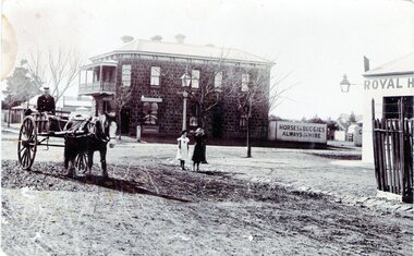
The photograph was taken at the intersection of Brook and Evans Streets in Sunbury. The two storey bluestone building was the Rupertswood Hotel, which was on the NE corner of the intersection and the single storey Royal Hotel building in the foreground was on the opposite corner. The Millett family originally owned both hotels. The Rupertswood Hotel was demolished in December 1974 to make way for a modern retail store. In 1939 the old Royal Hotel building was damaged by fire and replaced with a two storey red brick building.The Rupertswood and Royal Hotels were two of the earliest hotels to be erected in the Sunbury township.A non-digital black and white photograph of a street photograph featuring an intersection with a two storey bluestone building on one corner and a partial view of a single storey rendered building on the opposite corner. Two children are standing on the side of the road and a man is in a horse-drawn jinker. george millett, royal hotel, rupertswood hotel, evans street, brook street, hotels -
Stawell Historical Society Inc
Archive, S. Isaacson Store Main Street Stawell. Daily Sales Book, 1888 - 1889
... corner's. S. Isaacson Store Main Street Stawell. Daily Sales Book ...Green naterial cover with red binding on spine and outer corner's. Label mostly missing Legible Print reads From S.ISAACS Family Draper Silk Mercer a From Feb MAIN stawell, business -
 Stawell Historical Society Inc
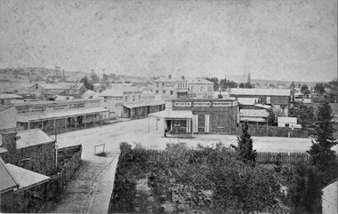
Photograph, Patrick Street and the Corner of Sloane Street with Stawell Court House in the background & St Patricks Church on the Horizon 1878
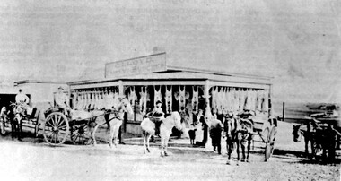
Patrick Street Sloane Street intersection in the 1880’s (Herbert Photo) On Big Hill side of Patrick Street is Matthew Cairns Plumber & Gasfitter, R. Greenwood Tailor, Mrs. Goodwin Cafe & Restaurant, Mack's Hotel, Grocer, Boot and Shoemaker, J. Farleys Auction Room, J.B. Wallis Royal Exchange Hotel, Stawell Court House and St Patricks Church in Distance On corner of Patrick and Sloane Streets, Melbourne Cash Store Wine Spirits & Provisions. In background mining poppet head behind livery stable. St Patrick Church in distance on right. 1878Patrick St, Sloane St intersection looking south . The Stawell Library now occupies this corner.Victorian Views. C. Herbert, Photo. Stawell 1878stawell business streetscape -
 Stawell Historical Society Inc
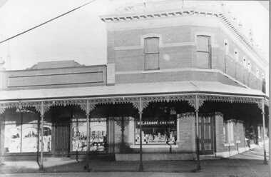
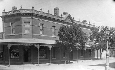
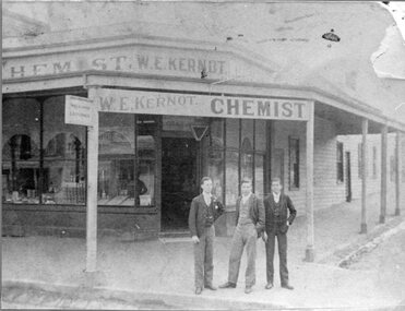
Photograph, Mr W.E. Kernot's Chemist Store on the corner of Main & Wimmera Streets Stawell
... Mr W.E. Kernot's Chemist Store on the corner of Main... Street Stawell Mr W.E. Kernot's Chemist Store on the corner ...W.E. Kernot Chemist Corner of Main Street and Wimmera Streetstawell -
 Stawell Historical Society Inc
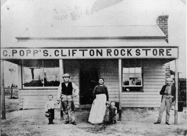
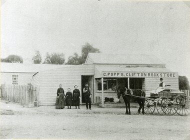
Photograph, Mr C. Popp’s Clifton Rock Store on the the corner of Newington Road and Sophia Street Stawell
... Mr C. Popp’s Clifton Rock Store on the the corner of... grampians C. Popp’s Clifton Rock Store simple wooden cottage ...C. Popp’s Clifton Rock Store simple wooden cottage with verandah across front. Located at corner of Newington Road and Sophia Street.stawell -
 Stawell Historical Society Inc
Photograph, Mr C. Popp’s Clifton Rock Store on the corner of Newington Road & Sophia Street
... Mr C. Popp’s Clifton Rock Store on the corner of Newington... grampians Clifton Rock Store (C. Popp’s) Cnr Newington Road ...Clifton Rock Store (C. Popp’s) Cnr Newington Road and Sophia Streetstawell business -
 Stawell Historical Society Inc
Photograph, Mr W.E. Kernot's Chemist Store on the corner of Main & Wimmera Streets Stawell
... Mr W.E. Kernot's Chemist Store on the corner of Main... Street Stawell Mr W.E. Kernot's Chemist Store on the corner ...W.E. Kernot Chemist Corner of Main Street and Wimmera Streetstawell -
 Beechworth Honey Archive
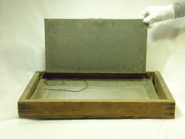
Antique Wax Foundation Mould
To use this foundation mould, melted beeswax was poured , the lid was placed on top, and the wax allowed to cool. The mould was then separated, and the beeswax foundation sheet taken out. Once placed in a hive, bees used the honeycomb impression created by the mould to draw out honey comb cells to store honey and polen. This mould was used by Bill Voigt, a beekeeping friend of the Robinson family. It was donated by Wilma, Val and Richard Voigt.This is antique equipment used by known beekeepers. Rectangular box with base and no lid. Constructed from wood, joined with metal nails in the corners. Inside box is a metal mould base with hexagonal imprint and metal mould lid with hexagonal imprint.antique, old, wax, foundation, mould, beechworth honey, voigt, robinson -
Beechworth Honey Archive
Honey Tin
This tin holds 60 pounds of honey. All honey used to be stored and transported in tins, manufactured to industry standards. The tins were eventually replaced by 44 gallon drums, which would hold 300 Kg of honey. Now, plastic food-grade pallecons are used; they hold 1500 Kg.Four gallon honey tin. Metal, rectangular tin. Rusted. Small handle on top. Circular hole in corner on top.four, gallon, honey, tin, beechworth honey -
 Surrey Hills Historical Society Collection
Photograph, Edward Lloyd's butcher shop
Lloyd butchers were located on the corner of Elgar & Whitehorse Roads (within the Surrey Hills postal district). From 1920-1950 Edward Lloyd also had a store at 112 Union Road, Surrey Hills. Atkinson's fruit & vegetable store was next to the Elgar Road facility. A black and white photograph of Lloyd's family butcher shop showing the carcasses hanging around the verandah. There are a few horse and delivery carts in the foreground.lloyd's butcher shop, atkinson's fruit and vegetable shop, carters, land transport, carts and wagons, horse drawn vehicles, mont albert, box hill, whitehorse road, elgar road, edward lloyd (mr) -
 Surrey Hills Historical Society Collection
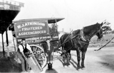
Photograph, Delivery cart outside Mr & Mrs W. J. Atkinsons's greengrocery business near the corner of Elgar and Whitehorse Roads, c1930
... business and general store near the corner of Whitehorse and Elgar... Atkinson’s greengrocery business and general store near the corner ...Delivery cart of Mr & Mrs W J Atkinson’s greengrocery business and general store near the corner of Whitehorse and Elgar Roads, c 1930. Emma Uebergang and William James Atkinson married in 1930. They ran a mixed business in Whitehorse Road from 1926-1952. Stock included fruit and vegetables, sweets and some groceries. With Mr Atkinson is Albert Cunnington who in about 1930 helped with deliveries. To the left can be seen Whitehorse Road as it approaches the shopping centre and over the back of the horse can be seen the White Horse Hotel. This was demolished in 1938.A black and white photograph of a horse and delivery cart identified as W. J. Atkinson Fruiterer and Greengrocer, 33? Whitehorse Road Box Hill.land transport, carts and wagons, horse drawn vehicles, fruiterer and greengrocer, whitehorse road, elgar road, mont albert, box hill, mr william james atkinson, mrs emma gertrude atkinson, miss emma gerte uebergang, mr albert cunningham -
 Surrey Hills Historical Society Collection
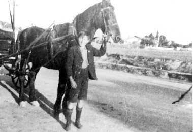
Photograph, Albert Cunnington with horse and cart
The boy is Albert Cunnington who in about 1930 helped with deliveries for Atkinson's greengrocery business and general store located at 815 Whitehorse Road. The photo is taken in Whitehorse Road, near the corner of Elgar Road looking towards Zetland Road. No details are known about Albert. The business was owned by Emma and William Atkinson. Emma was born in East Doncaster in 1903, the daughter of Carl Heinrich Uebergang and Sarah Buck. Emma’s grandparents were pioneers in Doncaster from 1855 and her father had an orchard in Andersons Creek Road, which was sold in 1961. She married William James Atkinson in 1930 and the Atkinsons ran the store from c1930 to c1950. (See file for further details). In retirement the couple lived at 63 Zetland Road, Mont Albert and William continued to work as an orchard hand. Emma died in March 2000 and is buried in Templestowe Cemetery. (Chivers Lawn TE-CHI_L*H***28) along with her husband who died in 1977.A black and white photograph of a young boy holding a horse, who is attached to a cart.land transport, carts and wagons, horse drawn vehicles, fruiterer and greengrocer, mont albert, box hill, whitehorse road, elgar road, mr william james atkinson, miss emma gerte uebergang, mrs emma gertrude atkinson, mr albert cunnington -
 Surrey Hills Historical Society Collection
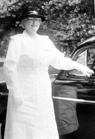
Photograph, Mrs Emma Atkinson
Emma was born in East Doncaster in 1903, the daughter of Carl Heinrich Uebergang and Sarah Buck. Emma’s grandparents were pioneers in Doncaster from 1855 and her father had an orchard in Andersons Creek Road, which was sold in 1961. Mr & Mrs Atkinson had a green-grocery business and general store at 815 Whitehorse Road, almost on the corner of Elgar Road from 1930 until about 1950. (See file for further details). In retirement the couple lived at 63 Zetland Road, Mont Albert and William continued to work as an orchard hand. Emma died in 2000 and is buried in Templestowe Cemetery. In this photo Mrs Atkinson is in the uniform of St. Johns Ambulance. In 1963 she was awarded a ‘Medal of Honour for Efficient Service’ by the Governor Sir Rowan Delacombe. (See file for further details) A black and white photograph of a lady dressed in a white uniform, complete with hat and gloves, standing beside a car.st. john ambulance, awards, miss emma gertrude uebergang, miss emma gerte uebergang, mrs william james atkinson, mrs emma atkinson -
 Surrey Hills Historical Society Collection
Photograph, Emma and William Atkinson's mixed business at 815 Whitehorse Road
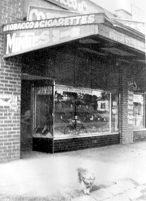
Emma was born in East Doncaster in 1903, the daughter of Carl Heinrich Uebergang and Sarah Buck. Emma’s grandparents were pioneers in Doncaster from 1855 and her father had an orchard in Andersons Creek Road. Mr & Mrs Atkinson had a green-grocery business and general store at 815 Whitehorse Road, almost on the corner of Elgar Road from 1930 until about 1950 . Lloyd's butchers business was next door. In retirement the couple lived at 63 Zetland Road, Mont Albert and William continued to work as an orchard hand. Emma died in 2000 and is buried in Templestowe Cemetery. (See file for further details).A black and white photograph of a shop front. The verandah advertises "tobacco and cigarettes", "Minties", "Fruiterer". A small dog is standing on the pavement.lloyds butchers, elgar road, whitehorse road, box hill, animals, william james atkinson (mr), fruiterer and greengrocer, emma gerte uebergang (miss), emma gertrude uebergang (miss) -
 Surrey Hills Historical Society Collection
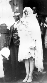
Photograph, Mr William and Mrs Emma Atkinson on their marriage in 1930
Emma Gerte (Gertrude) Uebergang married William James Atkinson in 1930. Emma was born in East Doncaster in 1903, the daughter of Carl Heinrich Uebergang and Sarah Buck. Emma’s grandparents were pioneers in Doncaster from 1855 and her father had an orchard in Andersons Creek Road. Mr & Mrs Atkinson had a greengrocery business and general store at 815 Whitehorse Road, almost on the corner of Elgar Road from 1930 until about 1950. (See file for further details). In retirement the couple lived at 63 Zetland Road, Mont Albert and William continued to work as an orchard hand. Emma died in 2000 and is buried in Templestowe Cemetery. A black and white photograph of a happy bridal couple. The lady is wearing a knee length dress and a calf length veil. The man is dressed in a suit. The bride is carrying some flowers.wedding dresses, clothing and dress, miss emma gerte uebergang, mr william james atkinson -
 Surrey Hills Historical Society Collection
Photograph, 1 Russell Street, Surrey Hills in 1988
1 Russell Street was built in 1888 and from 1888–1905 (maybe 1911, as his death notice says he died at Russell Street) it was the home of James Burrell, a blacksmith. His smithy was on the corner of Canterbury Road. In 1893 a block of land (No.3 ) was bought to establish the fire station and James Burrell acted as fire officer and stored the reel and hose until the station was built. From 1911–1928 it was the fire station residence, as the brigade gained status. James Burrell (1860-1911) married Elizabeth Wilson (1862-1925). She was daughter of Edward Wilson. They had 4 children: James Herbert, known as Bert (1888-1953); Aleck (1890-1951); William Spencer, known as Bill, (1893-1976) and Elsie May (1898-1990). Both James and Elizabeth Burrell are buried in Burwood Cemetery. From 1930–1943 Michael Ginnane, retired station master, and members of his family lived in the house. Michael Ginnane (1864-1935) married Annie Mary Brock (1868-1945). Both were born in the Ballarat area. They had 10 children. From 1913-1917 he was station master at Woodend. In the 1925 electoral rolls the family is listed as living at Surrey Hills station. There was a station master's house adjacent to the station (demolished and the site now part of the car park accessed off Blackburn Street). They are again listed here in the 1925 electoral roll. By 1931 they are at 1 Russell Street and he is listed as a retired station master. The following children lived in Surrey Hills: John James (Clerk) - 1922 Mary Ellen (HD) - 1922, 1925, 1931 Michael Thomas (labourer) - 1922 Annie Florence (dressmaker) - 1925, 1931 William Patrick (railwayman) - 1925 Elizabeth Catherine (sales) - 1931 Patrick Leo (postman) - 1931. A black and white photograph taken on an angle from across the street of a mid-late Victorian style cottage with multi-coloured brickwork. There is a large tree in the front garden, no fence and a letterbox on a lean.(mr) james burrell, blacksmiths, canterbury road, surrey hills, fire officers, (mr) michael ginnane, station masters, fire stations, mid-victorian style, (miss) elizabeth wilson, (mrs) elizabeth burrell, james herbert burrell, aleck burrell, william (bill) spencer burrell, elsie may burrell, (miss) annie mary brock, (mrs) annie mary ginnane, john james ginnane, (miss) mary ellen ginnane, michael thomas ginnane; (miss) annie florence ginnane; william patrick ginnane; elizabeth catherine ginnane; patrick leo ginnanean), late-victorian style, russell street