Showing 2417 items
matching townships
-
 Federation University Historical Collection
Document, Declaration of Ernest by owners of land in Yendon being held as a site for Public Hall and Free Library; 1891, 1891
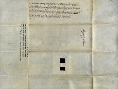
Document outlining the agreement between five males, all residents of Yendon. Land that had been purchased - being part of Crown Allotment Five Section six, Township of Buninyong East, Parish of Buninyong, County of Grant, has been purchased "as a site for a public hall and free library for the use and benefit of the inhabitants of the Township of Yendon."Thick paper, hand written. Red dots indicate places for signatures Document stamped in green - 0122083 Signatures of; John Winterburn Kemp, Philip Ballantyne, Samuel Henry Mayo, Thomas Dooley, Thomas Watsondeclaration of ernest, land title, free library, public hall, yendon, buninyong, paris of buninyong, county of grant, john winterburn kemp, philip ballantyne, samuel henry mayo, thomas dooley, thomas watson -
 Bendigo Historical Society Inc.
Map - CAMPBELL COLLECTION: BENDIGO AND DISTRICT MAPS, 10-5-29
Map. Mandurang, Scale 20 chains to an inch. Total area 5746 acres. Kennington, Township of Mandurang. To accompany my report of 10-5-29 R. Marshall, Forest assessor. Drawn by I.M.K. (number 399 in map cupboard 1)I.M.K.map, bendigo, allotments -
Clunes Museum
Photograph
FIVE PHOTOGRAPHS OF HISTORIC CLUNES. FIVE VIEWS FROM THE PAST. 1.CLUNES IN THE EARLY SIXTIES, 2. TOWNSHIP OF CLUNES FROM THE ROCKS, 3. CLUNES HOSPITAL,4.CLUNES TOWN HALL AND COURT HOUSE, 5. BUTTER FACTORY, CLUNES.local history, photographs, clunes buildings -
 Lakes Entrance Regional Historical Society (operating as Lakes Entrance History Centre & Museum)
Photograph, 1935c
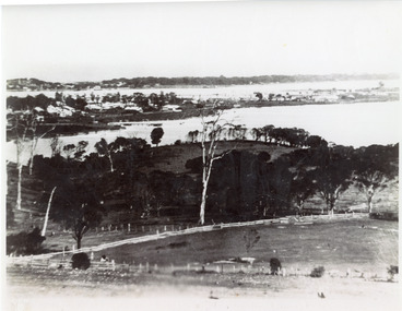
Enlarged from postcard produced for Mrs Allen to advertise Allen's Tearoom at the brow of Myer St hill, known as Allen's Hill to locals.|This is the paired before photograph showing the left hand side on Butchers paddock in the panoramic views, the right hand side number 01715. This photograph used in the 150 year Lakes Entrance 1858-2008 display.Black and white photograph of the township, taken from Allen's Hill, Myer St. It shows the town between Cunninghame Arm and North Arm, cleared and fenced paddocks in foreground, New Works village and sand hummocks in distance. Lakes Entrance Victoriaboats and boating, township, waterways, topography -
 Lakes Entrance Regional Historical Society (operating as Lakes Entrance History Centre & Museum)
Photograph, 1900c
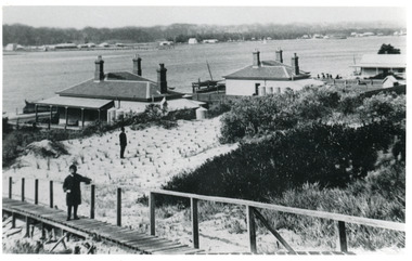
Also black and white copy 9 x 13 cmBlack and white photograph showing buildings on dunes. From left is harbour masters house, harbour engineers house, and Carpenters house. Child on boardwalk and newly planted marram grass on dune. Township across Cunninghame Arm. Lakes Entrance Victoriawaterways, topography, township -
 Lakes Entrance Regional Historical Society (operating as Lakes Entrance History Centre & Museum)
Photograph, 1997c
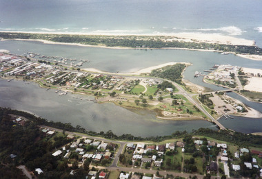
Colour print of aerial view looking south of western side of township. Shows housing on Kalimna Hill, North Arm, part of Bullock Island, Cunninghame Arm, the outer barrier and east pier of man made entrance. Lakes Entrance Victoriawaterways, islands, dredging, accommodation -
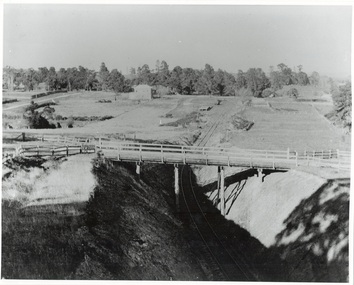 Buninyong & District Historical Society
Photograph - Photo of Original Photograph, W. Jack, Buninyong Railway Station precinct in 1940, 9 June 1940
Railway station and surrounds in 1940.B/W photograph f Buninyong Railway station precinct, taken 9 June 1940, showing Barkly St. trestle bridge over railway cutting, Butter Factory on left, station and rail yards on left, township to thye right.buninyong, railway, bunny, butter factory, bridge, cutting, barkly st. -
 City of Kingston
Pamphlet - Colour, Brock Bros, South Brighton Township Estate, 1888
Sales plan for land in the suburb of South Brighton (Moorabbin), bounded by Point Nepean Road, South Road, Patterson Street and the Mordialloc Railway Line. Incorporates Wolsely Street and Gordon StreetThe developing urban area of Moorabbin within the City of Kingston. This land sale pamphlet illustrates the subdivision of land within the municipality and the changing demographic of the district as new houses are constructed close to infrastructure.Colour pamphlet advertising for private sale the South Brighton Township Estate, South Brighton. Incorporates a map of the estate bordered by Point Nepean Road, South Road, Patterson Street, and the Mordialloc Railway Line. Includes Wolsley Street and Gordon Street. land sales, south brighton, estate, moorabbin -
 Lakes Entrance Regional Historical Society (operating as Lakes Entrance History Centre & Museum)
Photograph - Lakes Entrance, Gippsland Ports, 2006 c
Second copyColour aerial photograph of entrance from Bass Strait to Gippsland Lakes including Bullock Island Reeves Channel Rigby Island houses on Kalimna Hill and Princes Highway winding down Jemmys Point hill into township of Lakes Entrance Victoriaaerial photograph, ocean, waterways -
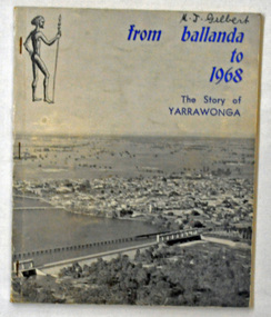 Orbost & District Historical Society
book, Yarrawonga Chronicle, From Ballanda to 1968; the story of Yarrawonga, October 1968
This book was published as part of the "Back to Yarrawonga" celebrations in October 1968 and the centenary of the First Survey of the Township of Yarrawonga.This is a useful reference tool on the history of Yarrawonga.A 90 pp paper back book titled, "From Ballanda to 1968; The Story of Yarrawonga". On the front cover on a glossy grey background is a photograph of Yarrawonga. The title is in blue print.yarrawonga-history -
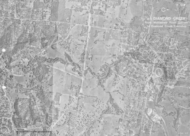 Eltham District Historical Society Inc
Work on paper (Sub-Item) - Photograph, Diamond Creek from Wattletree Road, Eltham to Diamond Creek township
Black and white aerial view of Diamond Creek from Wattletree Road, Eltham to Diamond Creek Townshipeltham, drain, diamond creek -
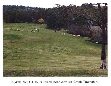 Eltham District Historical Society Inc
Work on paper (Sub-Item) - Photograph, Arthurs Creek near Arthurs Creek township, 1976
Colour photograph of Arthurs Creek near Arthurs Creek township. Hilly grassed landscape with cattle in the backgroundarthurs creek, cattle, farm -
 Greensborough Historical Society
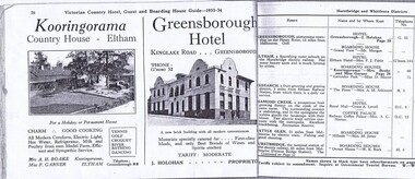
Advertisement, Greensborough Hotel Advertisement 1933-34, 1933-1934
An advertisement for Greensborough Hotel in the town of "Greensborough, picturesque township on the Plenty River, 13 miles from Melbourne."Photograph show the "new brick building with all modern conveniences'. Greensborough in the 1930s was a popular spot for picnics and holidays.2 pages from a Victorian Railways travel journal. Advertisement for Greensborough Hotel 1933-34. Photocopy from original journal.greensborough hotel, greensborough -
Greensborough Historical Society
Painting, Greensborough 1889, 1889 (original)
Greensborough in 1889, painted by Arthur Elliott. This is a copy of the original painting, one of two depicting Greensborough township.Framed and glazed coloured print of painting of Greensborough 1889greensborough, main street greensborough, arthur elliott -
 Kiewa Valley Historical Society
Postcards - Mt Beauty x2
Mt Beauty township is 30 km from the Falls Creek Ski Resort on the Bogong High PlainsTwo coloured postcards with wavy edges 1. Greetings from Mt Beauty 2. Fun in the Snowmt beauty near the snow -
Tatura Irrigation & Wartime Camps Museum
Folder, Recollections of Eildon
Recollections of construction of Eildon Dam and life in the township. Also contains 50 slide power point disc.Blue plastic cover. Black spine. White label- handwritten titlelocal history, water, irrigation, books, history, local, rural, industry -
 Hume City Civic Collection
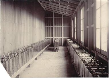
Photograph
A section of the former Sunbury Power House in the battery shed with machinery used to generate electricity for the Sunbury township.B/W photograph of an interior view of the Sunbury Power SupplyNumbers on back: 4�sunbury power supply, george evans collection -
 Stawell Historical Society Inc
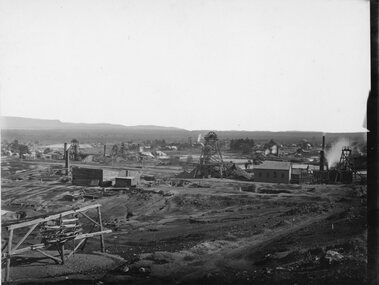
Photograph, Upper Main Street Stawell with the Patrick Street & Main Street corner at centre of Photo 1880
Stawell Township - Upper Main Street 1880. Patrick Street Main Street corner at centre of Photo.stawell -
 Otway Districts Historical Society
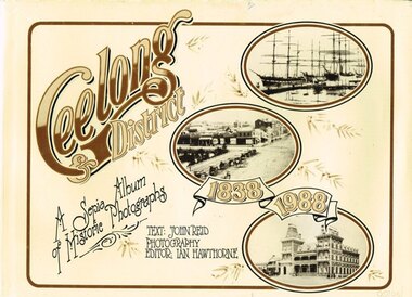
Book, Joval Commercial Productions, Geelong & District, 1988
Geelong was surveyed and declared a Township on October 26 1838 and this is the date adopted for the starting point for this photographic survey. Geelong & District. A photographic album of historic photographs in sepia, 1838-1988. John Reid (text); Ian Hawthorne (photo.) Geelong (Vic); Joval Commercial Productions; 1988. ii, 160, ii p.; illus. Hard cover. ISBN 0 7316 3060 2To Alf With love on your 80th birthday, August 27th 1989 XXX Ivygeelong; history; photography; john reid; ian hawthorne; -
 Sunbury Family History and Heritage Society Inc.
Photograph
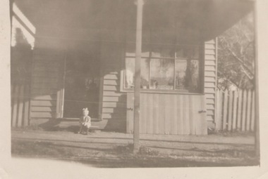
Many of the early shops found in the Sunbury township were small weatherboard buildings similar to the one in the photograph.A sepia photograph of a little child seated on a step outside a detached weatherboard building, which is a small shop..shops -
 Buninyong Visitor Information Centre
Photograph, 'Fassifern' Herriot Street, Buninyong
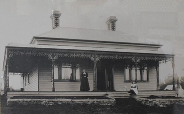
The framed photograph was presented to the Buninyong Visitor Information Centre in 1988 to mark the 150th anniversary of the township of Buninyong. Framed copy of historical photograph showing Mrs. Rachel Kerr and her daughter, Grace, on the verandah of their house 'Fassifern' in Herriott Street, Buninyong, early 1900s. The house was first owned by Mr. David Kerr. Framed photograph includes a label providing historical data and donation details.buninyong, houses, costume -
 Greensborough Historical Society
Photograph - Digital image, Portrait of Edward Green, 1850c
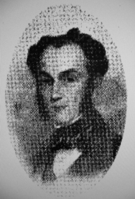
Portrait of Edward Green. In the 1840s, Edward B. Green ran the mail service between Melbourne and Sydney and owned a parcel of land on the Plenty River. He engaged a surveyor to draw up plans and lay out a township on the slopes overlooking the river, and to mark out small farm holdings on the flats. This small township named after him is now Greensborough.Digital copy of portrait.edward bernard green, greensborough history -
 Ballarat Tramway Museum
Photograph - Colour Photograph/s - set of 8, Carolyn Dean, 22/11/2000 12:00:00 AM
Set of eight colour prints of the Ballarat COTMA Conference 2000 visits to the MTPA depot at Haddon, the township of Clunes and to CMR Muckleford Photographed on 22/11/2000 at Haddon and on 23/11/2000 at Clunes and Muckleford. Photographs by Carolyn Dean. .1 - No. 663, 670 and 407 at Haddon MTPA depot .2 - COTMA delegates at Haddon BBQ .3 - No. 407 on operating track at Haddon .4 - Clunes war memorial .5 - Clunes township main street .6 - Muckleford station nameboard .7 - J549 at Muckleford station .8 - ditto Printed on Kodak paper.On rear of each print is "263.3 or .4, or .5" and date "22.11.00" or "23.11.00" in ink.btm, haddon, cotma, muckleford, clunes, tram 663, tram 670, tram 407 -
 Ringwood and District Historical Society
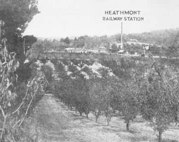
Photograph, View of what was Heathmont township taken from about Royal Avenue looking at Mr. Herman Pump's orchard. Old bridge over Canterbury Road can be seen on left
Typed below photograph, "View of what was Heathmont township taken from about Royal Avenue looking at Mr. Herman Pump's orchard. Old bridge over Canterbury Road can be seen on left." -
 Greensborough Historical Society
Photograph - Digital image, Panorama Overlooking Greensborough, 1925c
Photograph shows the view overlooking the Greensborough township in the first half of the 20th Century. It shows the rural nature of the area.Digital copy of black and white photograph.greensborough -
 Stawell Historical Society Inc
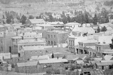
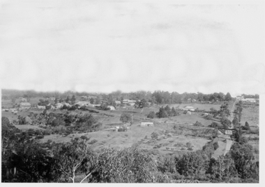
Photograph, Panorama of Stawell Township taken from Big Hill c1910 -- 4 Photos
Panorama of Stawell Township c1910 Taken from Big Hill. Three original images in Photo Cabinet 3.stawell mining -
 Stawell Historical Society Inc
Photograph, Upper Main Street Stawell with the Patrick & Sloane Street corner in the lower middle of Photo 1880
Stawell Township - Upper Main Street 1880. Patrick Street Sloane Street corner lower middle of Photo.stawell -
 Buninyong & District Historical Society
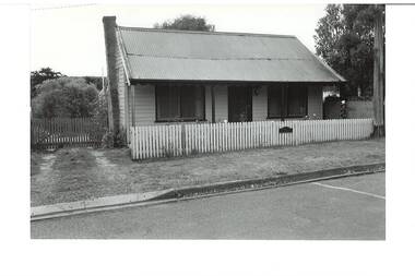
Photograph - Original B/W Photograph, Miner's cottage built on land owned by Thomas Hiscock in Learmonth St west, Buninyong, April 1994
The weatherboard cottage was built in the 1860's on land owned by Thomas Hiscock, the discoverer of gold near Buninyong township.The weatherboard cottage was built in the 1860's on land owned by Thomas Hiscock, the discoverer of gold near Buninyong. It is a good example of a miner's cottage of its era.B/W photo of Miner's cottage, Learmonth St west, Buninyong. Streetscape photo taken in 1993 of a weatherboard building with picket fence.miners cottage, house, building, weatherboard, thomas hiscock, hiscock, buninyong, learmonth st -
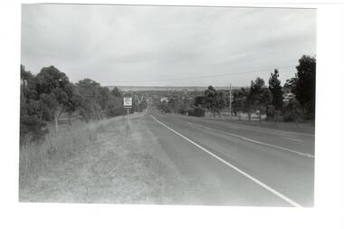 Buninyong & District Historical Society
Photograph - B/W photograph, Mr. Clive J. Brooks, Eastern approach to Buninyong Midland Highway 1994, April 1994
Approach to township of Buninyong prior to amalgamation with Ballarat City Council. Buninyong shire town sign visible in foreground.Record of Buninyong Shire prior to amalgamationBlack and white photograph of the Eastern approach to Buninyong from the Midland Highway taken from opposite Ballantrae looking West. In left foreground is an example of Buninyong shire town sign before amalgamation 1994.buninyong shire, midland highway, street scene -
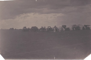 Sunbury Family History and Heritage Society Inc.
Photograph, Cam, 1900
From information written on the back of the image, this was 'a Dutch camp in township' which was there in 1900. There is no indication as to where the camp actually was.A dark sepia photograph of a campsite in on open are with tens and some large horse-drawn vehicles set up.