Showing 996 items matching "valley buildings"
-
 Marysville & District Historical Society
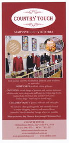
Ephemera (Item) - Advertising brochure, Country Touch, Unknown
... Marysville & District Historical Society 39 Darwin Street Marysville yarra-valley-and-the-dandenong-ranges An advertising brochure for Country Touch in Marysville in Victoria. An advertising brochure for Country Touch in Marysville in Victoria. Country Touch was established in 1995 in a mud brick building ...An advertising brochure for Country Touch in Marysville in Victoria.An advertising brochure for Country Touch in Marysville in Victoria. Country Touch was established in 1995 in a mud brick building designed for a pottery studio and gallery on the main street of Marysville in Victoria. By 2003 the pottery kilns were removed and the retail space expanded, however, this was destroyed in the Black Saturday bushfires. In July 2011 the new shop was officially opened and is still trading to this day. marysville, victoria, country touch, 2009 black saturday bushfires -
 Marysville & District Historical Society
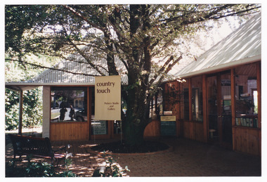
Photograph (Item) - Colour photograph, Unknown
... Marysville & District Historical Society 39 Darwin Street Marysville yarra-valley-and-the-dandenong-ranges A colour photograph of Country Touch in Marysville in Victoria. A colour photograph of Country Touch in Marysville in Victoria. Country Touch was established in 1995 in a mud brick building ...A colour photograph of Country Touch in Marysville in Victoria.A colour photograph of Country Touch in Marysville in Victoria. Country Touch was established in 1995 in a mud brick building designed for a pottery studio and gallery on the main street of Marysville in Victoria. By 2003 the pottery kilns were removed and the retail space expanded, however, this was destroyed in the Black Saturday bushfires. In July 2011 the new shop was officially opened and is still trading to this day. marysville, victoria, country touch, 2009 black saturday bushfires -
 Marysville & District Historical Society
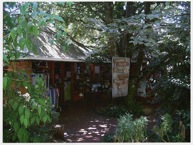
Photograph (Item) - Colour photograph, Unknown
... Marysville & District Historical Society 39 Darwin Street Marysville yarra-valley-and-the-dandenong-ranges A colour photograph of Country Touch in Marysville in Victoria. A colour photograph of Country Touch in Marysville in Victoria. Country Touch was established in 1995 in a mud brick building ...A colour photograph of Country Touch in Marysville in Victoria.A colour photograph of Country Touch in Marysville in Victoria. Country Touch was established in 1995 in a mud brick building designed for a pottery studio and gallery on the main street of Marysville in Victoria. By 2003 the pottery kilns were removed and the retail space expanded, however, this was destroyed in the Black Saturday bushfires. In July 2011 the new shop was officially opened and is still trading to this day. marysville, victoria, country touch, 2009 black saturday bushfires -
 Marysville & District Historical Society
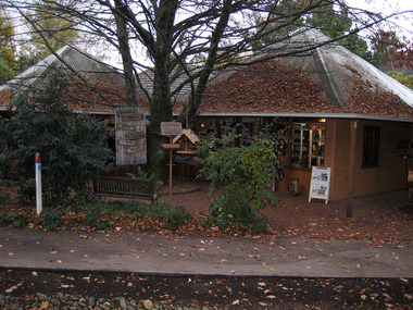
Photograph (Item) - Colour photograph, Unknown
... Marysville & District Historical Society 39 Darwin Street Marysville yarra-valley-and-the-dandenong-ranges A digital copy of a colour photograph of Country Touch in Marysville in Victoria. A digital copy of a colour photograph of Country Touch in Marysville in Victoria. Country Touch was established in 1995 in a mud brick building ...A digital copy of a colour photograph of Country Touch in Marysville in Victoria.A digital copy of a colour photograph of Country Touch in Marysville in Victoria. Country Touch was established in 1995 in a mud brick building designed for a pottery studio and gallery on the main street of Marysville in Victoria. By 2003 the pottery kilns were removed and the retail space expanded, however, this was destroyed in the Black Saturday bushfires. In July 2011 the new shop was officially opened and is still trading to this day. marysville, victoria, country touch, 2009 black saturday bushfires -
 Marysville & District Historical Society
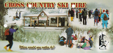
Ephemera (Item) - Advertising brochure, Cross Country Ski Hire, Unknown
... Marysville & District Historical Society 39 Darwin Street Marysville yarra-valley-and-the-dandenong-ranges An advertising brochure for Cross Country Ski Hire in Marysville in Victoria. An advertising brochure for Cross Country Ski Hire in Marysville in Victoria. This building ...An advertising brochure for Cross Country Ski Hire in Marysville in Victoria.An advertising brochure for Cross Country Ski Hire in Marysville in Victoria. This building, along with most of the town of Marysville, was destroyed in the 2009 Black Saturday bushfires.marysville, victoria, cross counry ski hire, lake mountain, 2009 black saturday bushfires -
 Marysville & District Historical Society
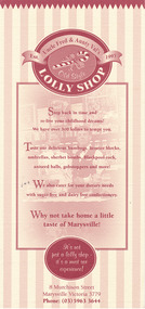
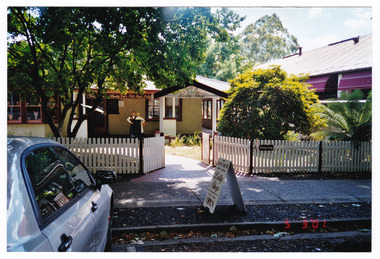
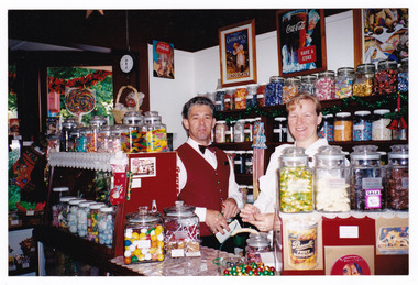
Ephemera (Item) - Advertising brochure, Uncle Fred & Aunty Val's Old Style Lolly Shop, Unknown
... valley-and-the-dandenong-ranges An advertising brochure for Uncle Fred & Aunty Val's Old Style Lolly Shop in Marysville in Victoria. An advertising brochure for Uncle Fred & Aunty Val's Old Style Lolly Shop in Marysville in Victoria. This popular shop in Marysville was originally opened in the old Barton house by Frank and Val Pryor. The lolly shop premises were destroyed, along with most of the buildings ...An advertising brochure for Uncle Fred & Aunty Val's Old Style Lolly Shop in Marysville in Victoria.An advertising brochure for Uncle Fred & Aunty Val's Old Style Lolly Shop in Marysville in Victoria. This popular shop in Marysville was originally opened in the old Barton house by Frank and Val Pryor. The lolly shop premises were destroyed, along with most of the buildings in Marysville, in the 2009 Black Saturday bushfires. The then owner, Julia Harris, reopened the lolly shop in an old shipping container until the premises was rebuilt. It is a popular shop in Marysville to this day.marysville, victoria, uncle fred & aunty val's old style lolly shop, marysville lolly shop, advertising brochure, frank pryor, val pryor, 2009 black saturday bushfires -
 Marysville & District Historical Society
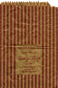
Ephemera (Item) - Paper bag, Unknown
... valley-and-the-dandenong-ranges A paper bag from Uncle Fred & Aunty Val's Old Style Lolly Shop in Marysville in Victoria. A paper bag from Uncle Fred & Aunty Val's Old Style Lolly Shop in Marysville in Victoria. This popular shop in Marysville was originally opened in the old Barton house by Frank and Val Pryor in 1995. The lolly shop premises were destroyed, along with most of the buildings ...A paper bag from Uncle Fred & Aunty Val's Old Style Lolly Shop in Marysville in Victoria.A paper bag from Uncle Fred & Aunty Val's Old Style Lolly Shop in Marysville in Victoria. This popular shop in Marysville was originally opened in the old Barton house by Frank and Val Pryor in 1995. The lolly shop premises were destroyed, along with most of the buildings in Marysville, in the 2009 Black Saturday bushfires. The then owner, Julia Harris, reopened the lolly shop in an old shipping container until the premises was rebuilt. It is a popular shop in Marysville to this day.marysville, victoria, uncle fred & aunty val's old style lolly shop, marysville lolly shop, frank pryor, val pryor, 2009 black saturday bushfires -
 Marysville & District Historical Society
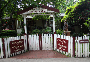
Photograph (Item) - Colour photograph, Unknown
... valley-and-the-dandenong-ranges A colour photograph of Uncle Fred & Aunty Val's Old Style Lolly Shop in Marysville in Victoria. A colour photograph of Uncle Fred & Aunty Val's Old Style Lolly Shop in Marysville in Victoria. This popular shop in Marysville was originally opened in the old Barton house by Frank and Val Pryor in 1995. The lolly shop premises were destroyed, along with most of the buildings ...A colour photograph of Uncle Fred & Aunty Val's Old Style Lolly Shop in Marysville in Victoria.A colour photograph of Uncle Fred & Aunty Val's Old Style Lolly Shop in Marysville in Victoria. This popular shop in Marysville was originally opened in the old Barton house by Frank and Val Pryor in 1995. The lolly shop premises were destroyed, along with most of the buildings in Marysville, in the 2009 Black Saturday bushfires. The then owner, Julia Harris, reopened the lolly shop in an old shipping container until the premises was rebuilt. It is a popular shop in Marysville to this day.marysville, victoria, uncle fred & aunty val's old style lolly shop, marysville lolly shop, frank pryor, val pryor, 2009 black saturday bushfires, photograph -
 Marysville & District Historical Society
Photograph (Item) - Colour photograph, 05-03-2001
... valley-and-the-dandenong-ranges A colour photograph of Uncle Fred & Aunty Val's Old Style Lolly Shop in Marysville in Victoria. A colour photograph of Uncle Fred & Aunty Val's Old Style Lolly Shop in Marysville in Victoria. This popular shop in Marysville was originally opened in the old Barton house by Frank and Val Pryor in 1995. The lolly shop premises were destroyed, along with most of the buildings ...A colour photograph of Uncle Fred & Aunty Val's Old Style Lolly Shop in Marysville in Victoria.A colour photograph of Uncle Fred & Aunty Val's Old Style Lolly Shop in Marysville in Victoria. This popular shop in Marysville was originally opened in the old Barton house by Frank and Val Pryor in 1995. The lolly shop premises were destroyed, along with most of the buildings in Marysville, in the 2009 Black Saturday bushfires. The then owner, Julia Harris, reopened the lolly shop in an old shipping container until the premises was rebuilt. It is a popular shop in Marysville to this day.marysville, victoria, uncle fred & aunty val's old style lolly shop, marysville lolly shop, frank pryor, val pryor, 2009 black saturday bushfires, photograph -
 Marysville & District Historical Society
Photograph (Item) - Colour photograph, Unknown
... valley-and-the-dandenong-ranges A colour photograph of Uncle Fred & Aunty Val's Old Style Lolly Shop in Marysville in Victoria. A colour photograph of Uncle Fred & Aunty Val's Old Style Lolly Shop in Marysville in Victoria. This popular shop in Marysville was originally opened in the old Barton house by Frank and Val Pryor in 1995. The lolly shop premises were destroyed, along with most of the buildings ...A colour photograph of Uncle Fred & Aunty Val's Old Style Lolly Shop in Marysville in Victoria.A colour photograph of Uncle Fred & Aunty Val's Old Style Lolly Shop in Marysville in Victoria. This popular shop in Marysville was originally opened in the old Barton house by Frank and Val Pryor in 1995. The lolly shop premises were destroyed, along with most of the buildings in Marysville, in the 2009 Black Saturday bushfires. The then owner, Julia Harris, reopened the lolly shop in an old shipping container until the premises was rebuilt. It is a popular shop in Marysville to this day.marysville, victoria, uncle fred & aunty val's old style lolly shop, marysville lolly shop, frank pryor, val pryor, 2009 black saturday bushfires, photograph -
 Marysville & District Historical Society
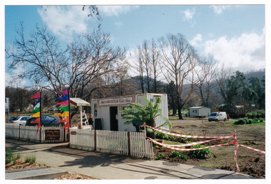
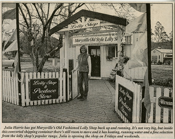
Photograph (Item) - Colour photograph, 22-08-2009
... valley-and-the-dandenong-ranges A colour photograph of the temporary premises of the Marysville Old Style Lolly Shop in Marysville in Victoria. A colour photograph of the temporary premises of the Marysville Old Style Lolly Shop in Marysville in Victoria. This photograph was taken after the 2009 Black Saturday bushfires which destroyed the building ...A colour photograph of the temporary premises of the Marysville Old Style Lolly Shop in Marysville in Victoria.A colour photograph of the temporary premises of the Marysville Old Style Lolly Shop in Marysville in Victoria. This photograph was taken after the 2009 Black Saturday bushfires which destroyed the building, along with most of the buildings in Marysville. This popular shop in Marysville was originally opened in the old Barton house by Frank and Val Pryor in 1995. The then owner, Julia Harris, reopened the lolly shop in an old shipping container until the premises was rebuilt. It is a popular shop in Marysville to this day.22/8/09 Marysvillemarysville, victoria, uncle fred & aunty val's old style lolly shop, marysville lolly shop, frank pryor, val pryor, 2009 black saturday bushfires, photograph -
 Marysville & District Historical Society
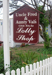
Photograph (Item) - Colour photograph, Unknown
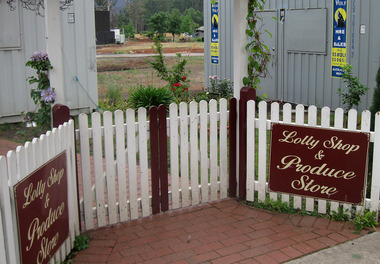
... valley-and-the-dandenong-ranges A colour photograph of the sign that was outside of Uncle Fred & Aunty Val's Old Style Lolly Shop in Marysville in Victoria. A colour photograph of the sign that was outside of Uncle Fred & Aunty Val's Old Style Lolly Shop in Marysville in Victoria. This photograph was taken after the 2009 Black Saturday bushfires which destroyed the building ...A colour photograph of the sign that was outside of Uncle Fred & Aunty Val's Old Style Lolly Shop in Marysville in Victoria.A colour photograph of the sign that was outside of Uncle Fred & Aunty Val's Old Style Lolly Shop in Marysville in Victoria. This photograph was taken after the 2009 Black Saturday bushfires which destroyed the building, along with most of the buildings in Marysville. This popular shop in Marysville was originally opened in the old Barton house by Frank and Val Pryor in 1995. The then owner, Julia Harris, reopened the lolly shop in an old shipping container until the premises was rebuilt. It is a popular shop in Marysville to this day.marysville, victoria, uncle fred & aunty val's old style lolly shop, marysville lolly shop, frank pryor, val pryor, 2009 black saturday bushfires, photograph -
 Marysville & District Historical Society
Photograph (Item) - Colour photograph, Unknown
... valley-and-the-dandenong-ranges A colour photograph of the sign that was outside of Uncle Fred & Aunty Val's Old Style Lolly Shop in Marysville in Victoria. A colour photograph of the sign that was outside of Uncle Fred & Aunty Val's Old Style Lolly Shop in Marysville in Victoria. This photograph was taken after the 2009 Black Saturday bushfires which destroyed the building ...A colour photograph of the sign that was outside of Uncle Fred & Aunty Val's Old Style Lolly Shop in Marysville in Victoria.A colour photograph of the sign that was outside of Uncle Fred & Aunty Val's Old Style Lolly Shop in Marysville in Victoria. This photograph was taken after the 2009 Black Saturday bushfires which destroyed the building, along with most of the buildings in Marysville. This popular shop in Marysville was originally opened in the old Barton house by Frank and Val Pryor in 1995. The then owner, Julia Harris, reopened the lolly shop in an old shipping container until the premises was rebuilt. It is a popular shop in Marysville to this day.marysville, victoria, uncle fred & aunty val's old style lolly shop, marysville lolly shop, frank pryor, val pryor, 2009 black saturday bushfires, photograph -
 Marysville & District Historical Society
Ephemera (Item) - Newspaper article, Unknown
... valley-and-the-dandenong-ranges A newspaper article on the Marysville Old Style Lolly Shop in Marysville in Victoria. A newspaper article on the Marysville Old Style Lolly Shop in Marysville in Victoria. This newspaper article was written after the 2009 Black Saturday bushfires which destroyed the building ...A newspaper article on the Marysville Old Style Lolly Shop in Marysville in Victoria.A newspaper article on the Marysville Old Style Lolly Shop in Marysville in Victoria. This newspaper article was written after the 2009 Black Saturday bushfires which destroyed the building, along with most of the buildings in Marysville. This popular shop in Marysville was originally opened in the old Barton house by Frank and Val Pryor in 1995. The then owner, Julia Harris, reopened the lolly shop in an old shipping container until the premises was rebuilt. It is a popular shop in Marysville to this day.marysville, victoria, uncle fred & aunty val's old style lolly shop, marysville lolly shop, frank pryor, val pryor, 2009 black saturday bushfires, newspaper article, julia harris -
 Marysville & District Historical Society
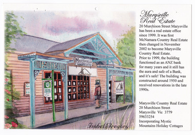
Ephemera (Item) - Calendar page, Isobel Gregory, Unknown
... valley-and-the-dandenong-ranges A page from a calendar showing the Marysville Real Estate in Marysville in Victoria. A page from a calendar showing the Marysville Real Estate in Marysville in Victoria. 20 Murchison Street Marysville has been a real estate office since 1999. It was first McNamara Country Real Estate then changed in November 2002 to become Marysville Country Real Estate. Prior to 1999, the building ...A page from a calendar showing the Marysville Real Estate in Marysville in Victoria.A page from a calendar showing the Marysville Real Estate in Marysville in Victoria. 20 Murchison Street Marysville has been a real estate office since 1999. It was first McNamara Country Real Estate then changed in November 2002 to become Marysville Country Real Estate. Prior to 1999, the building functioned as an ANZ bank for many years. The building was constructed around 1950 and was renovated in the late 1990s. The building, along with most of the buildings in Marysville, was destroyed in the 2009 Black Saturday bushfires.marysville, victoria, marysville real estate, calendar page, calendar, isobel gregory, 2009 black saturday bushfires -
 Marysville & District Historical Society
Photograph (Item) - Colour photograph, Unknown
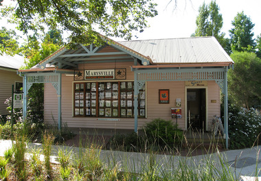
... valley-and-the-dandenong-ranges A colour photograph of Marysville Country Real Estate in Marysville in Victoria. A colour photograph of Marysville Country Real Estate in Marysville in Victoria. 20 Murchison Street Marysville has been a real estate office since 1999. It was first McNamara Country Real Estate then changed in November 2002 to become Marysville Country Real Estate. Prior to 1999, the building ...A colour photograph of Marysville Country Real Estate in Marysville in Victoria.A colour photograph of Marysville Country Real Estate in Marysville in Victoria. 20 Murchison Street Marysville has been a real estate office since 1999. It was first McNamara Country Real Estate then changed in November 2002 to become Marysville Country Real Estate. Prior to 1999, the building functioned as an ANZ bank for many years. The building was constructed around 1950 and was renovated in the late 1990s. The building, along with most of the buildings in Marysville, was destroyed in the 2009 Black Saturday bushfires.marysville, victoria, marysville real estate, photograph, 2009 black saturday bushfires -
 Marysville & District Historical Society
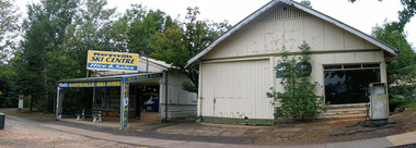
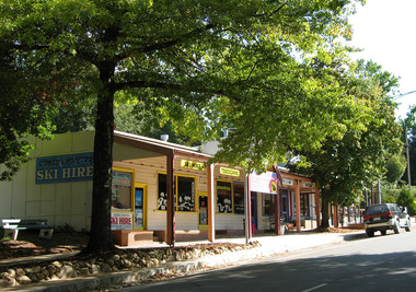
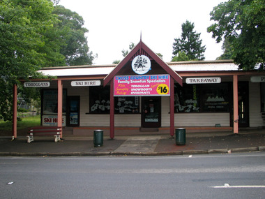
Photograph (Item) - Colour photograph, Unknown
... valley-and-the-dandenong-ranges A colour photograph of the Marysville Ski Centre in Victoria. A colour photograph of the Marysville Ski Centre in Victoria. Marysville Ski Centre is a family-owned business, which has been operated by Nat and Beryl Morandi since 1981. The business started from very humble beginnings hiring toboggans at Lake Mountain initially from the back of a Bedford Van, and then upgraded to a rickety old shed with the addition of ski equipment for hire. In 1983, Marysville Ski Centre commenced business in its current position in Marysville. Then this building ...A colour photograph of the Marysville Ski Centre in Victoria.A colour photograph of the Marysville Ski Centre in Victoria. Marysville Ski Centre is a family-owned business, which has been operated by Nat and Beryl Morandi since 1981. The business started from very humble beginnings hiring toboggans at Lake Mountain initially from the back of a Bedford Van, and then upgraded to a rickety old shed with the addition of ski equipment for hire. In 1983, Marysville Ski Centre commenced business in its current position in Marysville. Then this building was destroyed, along with most of the buildings in Marysville, during the 2009 Black Saturday bushfires. Currently, the business operates from their new custom-designed ski hire which has been built to cater for the different needs of the hire.marysville, victoria, marysville ski centre, photograph, nat morandi, beryl morandi, 2009 black saturday bushfires -
 Marysville & District Historical Society
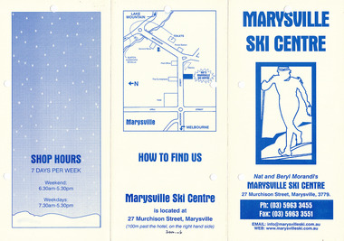
Ephemera (Item) - Advertising brochure, Marysville Ski Centre, Unknown
... valley-and-the-dandenong-ranges An advertising brochure for Marysville Ski Centre in Victoria. An advertising brochure for Marysville Ski Centre in Victoria. Marysville Ski Centre is a family-owned business, which has been operated by Nat and Beryl Morandi since 1981. The business started from very humble beginnings hiring toboggans at Lake Mountain initially from the back of a Bedford Van, and then upgraded to a rickety old shed with the addition of ski equipment for hire. In 1983, Marysville Ski Centre commenced business in its current position in Marysville. Then this building ...An advertising brochure for Marysville Ski Centre in Victoria.An advertising brochure for Marysville Ski Centre in Victoria. Marysville Ski Centre is a family-owned business, which has been operated by Nat and Beryl Morandi since 1981. The business started from very humble beginnings hiring toboggans at Lake Mountain initially from the back of a Bedford Van, and then upgraded to a rickety old shed with the addition of ski equipment for hire. In 1983, Marysville Ski Centre commenced business in its current position in Marysville. Then this building was destroyed, along with most of the buildings in Marysville, during the 2009 Black Saturday bushfires. Currently, the business operates from their new custom-designed ski hire which has been built to cater for the different needs of the hire.marysville, victoria, marysville ski centre, photograph, nat morandi, beryl morandi, 2009 black saturday bushfires -
 Marysville & District Historical Society
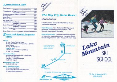
Ephemera (Item) - Advertising brochure, Learn To Ski With Lake Mountain Ski School, 1990
... valley-and-the-dandenong-ranges An advertising brochure for Lake Mountain Ski School in Victoria. An advertising brochure for Lake Mountain Ski School in Victoria. Marysville Ski Centre is a family-owned business, which has been operated by Nat and Beryl Morandi since 1981. The business started from very humble beginnings hiring toboggans at Lake Mountain initially from the back of a Bedford Van, and then upgraded to a rickety old shed with the addition of ski equipment for hire. In 1983, Marysville Ski Centre commenced business in its current position in Marysville. Then this building ...An advertising brochure for Lake Mountain Ski School in Victoria.An advertising brochure for Lake Mountain Ski School in Victoria. Marysville Ski Centre is a family-owned business, which has been operated by Nat and Beryl Morandi since 1981. The business started from very humble beginnings hiring toboggans at Lake Mountain initially from the back of a Bedford Van, and then upgraded to a rickety old shed with the addition of ski equipment for hire. In 1983, Marysville Ski Centre commenced business in its current position in Marysville. Then this building was destroyed, along with most of the buildings in Marysville, during the 2009 Black Saturday bushfires. Currently, the business operates from their new custom-designed ski hire which has been built to cater for the different needs of the hire.marysville, victoria, marysville ski centre, photograph, nat morandi, beryl morandi, 2009 black saturday bushfires, lake mountain ski school, lake mountain -
 Marysville & District Historical Society
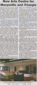
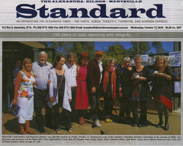
Newspaper (Item) - Newspaper article, Alexandra Standard, New Arts Centre for Marysville and Triangle, 04-07-2018
... Marysville & District Historical Society 39 Darwin Street Marysville yarra-valley-and-the-dandenong-ranges A newspaper article on the refurbishment of the arts centre in Marysville in Victoria. A newspaper article on the refurbishment of the arts centre in Marysville in Victoria. This building ...A newspaper article on the refurbishment of the arts centre in Marysville in Victoria.A newspaper article on the refurbishment of the arts centre in Marysville in Victoria. This building is known as MiRa-Marysville Information + Regional Artspace.Alex Standard 4 July 2018marysville, victoria, mira, marysville information and regional artspace -
 Marysville & District Historical Society
Newspaper (Item) - Newspaper article, Alexandra Standard, 12-10-2018
... Marysville & District Historical Society 39 Darwin Street Marysville yarra-valley-and-the-dandenong-ranges A newspaper photograph taken at the opening of MiRa-Marysville Information + Regional Artspace. A newspaper photograph taken at the opening of MiRa-Marysville Information + Regional Artspace. This building ...A newspaper photograph taken at the opening of MiRa-Marysville Information + Regional Artspace.A newspaper photograph taken at the opening of MiRa-Marysville Information + Regional Artspace. This building was opened on October 12, 2018.marysville, victoria, mira, marysville information and regional artspace -
 Marysville & District Historical Society
Newspaper (Item) - Newspaper article, Alexandra Standard, Looking in the MIRA, 1-07-2018
... Marysville & District Historical Society 39 Darwin Street Marysville yarra-valley-and-the-dandenong-ranges A newspaper article on MiRa-Marysville Information + Regional Artspace. A newspaper article on MiRa-Marysville Information + Regional Artspace. This building ...A newspaper article on MiRa-Marysville Information + Regional Artspace.A newspaper article on MiRa-Marysville Information + Regional Artspace. This building was opened on October 12, 2018.marysville, victoria, mira, marysville information and regional artspace -
 Marysville & District Historical Society
Photograph (Item) - Black and white photograph, Unknown
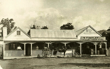
... valley-and-the-dandenong-ranges A black and white photograph of the Taggerty General Store in Victoria. A black and white photograph of the Taggerty General Store in Victoria. taggerty victoria taggerty general store photograph Original marked:- Mrs M. Gorman,/ 22 McKenzie St,/ Alexandra General Store at Taggerty. On road to Thornton, right side, on bend just pass Primary School TG6 POO448 A black and white photograph of the Taggerty General Store in Victoria. Shows a horse drawn sulky in front of the building ...A black and white photograph of the Taggerty General Store in Victoria.A black and white photograph of the Taggerty General Store in Victoria.Original marked:- Mrs M. Gorman,/ 22 McKenzie St,/ Alexandra General Store at Taggerty. On road to Thornton, right side, on bend just pass Primary School TG6 POO448taggerty, victoria, taggerty general store, photograph -
 Marysville & District Historical Society
Photograph (Item) - Colour photograph, Unknown
... Marysville & District Historical Society 39 Darwin Street Marysville yarra-valley-and-the-dandenong-ranges A digital copy of a colour photograph of Cross Country Ski Hire in Marysville in Victoria. A digital copy of a colour photograph of Cross Country Ski Hire in Marysville in Victoria. This building ...A digital copy of a colour photograph of Cross Country Ski Hire in Marysville in Victoria.A digital copy of a colour photograph of Cross Country Ski Hire in Marysville in Victoria. This building, along with most of the town of Marysville, was destroyed in the 2009 Black Saturday bushfires.marysville, victoria, cross country ski hire, ski hire, lake mountain, 2009 black saturday bushfires -
 Marysville & District Historical Society
Photograph (Item) - Colour photograph, Unknown
... Marysville & District Historical Society 39 Darwin Street Marysville yarra-valley-and-the-dandenong-ranges A digital copy of a colour photograph of Cross Country Ski Hire in Marysville in Victoria. A digital copy of a colour photograph of Cross Country Ski Hire in Marysville in Victoria. This building ...A digital copy of a colour photograph of Cross Country Ski Hire in Marysville in Victoria.A digital copy of a colour photograph of Cross Country Ski Hire in Marysville in Victoria. This building, along with most of the town of Marysville, was destroyed in the 2009 Black Saturday bushfires.marysville, victoria, cross counry ski hire, lake mountain, 2009 black saturday bushfires -
 Marysville & District Historical Society
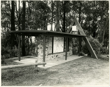
Photograph (Item) - Black and white photographs, Unknown
... Marysville & District Historical Society 39 Darwin Street Marysville yarra-valley-and-the-dandenong-ranges Two black and white photographs of the tourist information board which is at the entrance to Marysville. The Marysville Tourist and Progress Association were responsible for the building of this structure. ...Two black and white photographs of the tourist information board which is at the entrance to Marysville. The Marysville Tourist and Progress Association were responsible for the building of this structure. It contains maps and information for attractions in and around the local area as well as information pertaining to local clubs and organisations.Two black and white photographs of the tourist information board which is at the entrance to Marysville. The Marysville Tourist and Progress Association were responsible for the building of this structure. It contains maps and information for attractions in and around the local area as well as information pertaining to local clubs and organisations.marysville, victoria, marysville tourist and progress association, tourism information, tourism -
 Marysville & District Historical Society
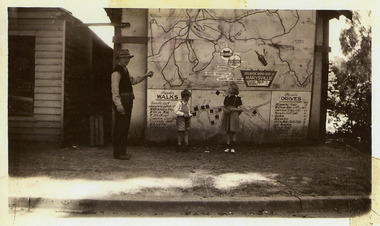
Photograph (Item) - Black and white photograph, 1949
... Marysville & District Historical Society 39 Darwin Street Marysville yarra-valley-and-the-dandenong-ranges A copy of a black and white photograph of an Atlantic Road Map of Marysville adhered to an unknown building in Marysville. ...A copy of a black and white photograph of an Atlantic Road Map of Marysville adhered to an unknown building in Marysville.A copy of a black and white photograph of an Atlantic Road Map of Marysville adhered to an unknown building in Marysville.marysville, victoria, maps, atlantic road map -
 Marysville & District Historical Society
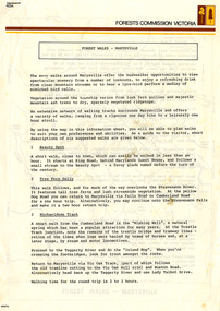
Flyer (Item) - Information Flyer, Forests Commission, Victoria, FOREST WALKS - MARYSVILLE, 1918-1983
... valley-and-the-dandenong-ranges An information flyer that was produced as a guide to the forest walks in and near Marysville by the Forests Commission of Victoria. The Forests Commission Victoria (FCV) was the main government authority responsible for management and protection of State forests in Victoria, Australia between 1918 and 1983. The Commission was responsible for ″forest policy, prevention and suppression of bushfires, issuing leases and licences, planting and thinning of forests, the development of plantations, reforestation, nurseries, forestry education, the development of commercial timber harvesting and marketing of produce, building and maintaining forest roads, provision of recreation facilities, protection of water, soils and wildlife, forest research and making recommendations on the acquisition or alienation of land for forest purposes″. ...An information flyer that was produced as a guide to the forest walks in and near Marysville by the Forests Commission of Victoria. The Forests Commission Victoria (FCV) was the main government authority responsible for management and protection of State forests in Victoria, Australia between 1918 and 1983. The Commission was responsible for ″forest policy, prevention and suppression of bushfires, issuing leases and licences, planting and thinning of forests, the development of plantations, reforestation, nurseries, forestry education, the development of commercial timber harvesting and marketing of produce, building and maintaining forest roads, provision of recreation facilities, protection of water, soils and wildlife, forest research and making recommendations on the acquisition or alienation of land for forest purposes″. An extensive network of walking tracks surrounds Marysville and they offer a variety of walks ranging in various levels of difficulty. This information flyer provides information such as the level of difficulty for six suggested walks around Marysville.An information flyer that was produced as a guide to the forest walks in and near Marysville by the Forests Commission of Victoria.marysville, victoria, australia, forest walks, forests commission victoria, beauty spot walk, tree fern gully walk, michaeldene track, keppel track, woods lookout track -
 Marysville & District Historical Society
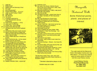
Ephemera (Item) - Information brochure, Marysville & District Historical Society Inc, Marysville Historical Walk, 2003
... Marysville & District Historical Society 39 Darwin Street Marysville yarra-valley-and-the-dandenong-ranges An information brochure outlining a historical walk around Marysville that takes in some of the more historical sites in the township. This brochure was created by the Marysville & District Historical Society Inc in 2003. Most of the buildings ...An information brochure outlining a historical walk around Marysville that takes in some of the more historical sites in the township. This brochure was created by the Marysville & District Historical Society Inc in 2003. Most of the buildings, along with most of the town, were destroyed in the 2009 Black Saturday bushfires.An information brochure outlining a historical walk around Marysville that takes in some of the more historical sites in the township.marysville, victoria, australia, information brochure, 2009 black saturday bushfires -
 Marysville & District Historical Society
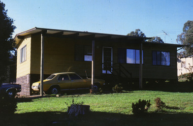
Photograph (Item) - Colour photograph, Unknown
... Marysville & District Historical Society 39 Darwin Street Marysville yarra-valley-and-the-dandenong-ranges A colour photograph of one of the cottages at Amber View Cottages in Marysville. These cottages, along with most of the buildings in the township, were destroyed in the 2009 Black Saturday bushfires. ...A colour photograph of one of the cottages at Amber View Cottages in Marysville. These cottages, along with most of the buildings in the township, were destroyed in the 2009 Black Saturday bushfires.A colour photograph of one of the cottages at Amber View Cottages in Marysville.amber view cottages, marysville, victoria, australia, accommodation, photograph, 2009 black saturday bushfires