Showing 127085 items
matching main-road
-
 Eltham District Historical Society Inc
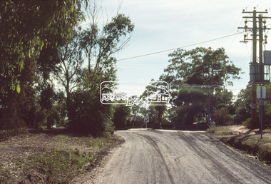
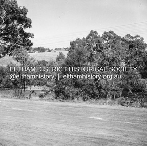
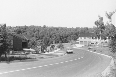
Slide, Bonds Road, Lower Plenty, Mar. 1981
One of a series of images of road infrastructure focussed on Bonds Road, Lower Plenty, the section connecting Old Eltham Road with Rosehill Road, taken by Eltham Shire Council Planning and Engineering officers. They provide perspective of the changes in housing styles and road development that began sweeping in from the mid 1970s with increasing urbanisation of what was once more outlying suburbs and regions. All images have been identified with GPS35 mm colour positive transparency (1 of 13) Mount - Kodak Kodachrome CardProcessed Mar 1981infrastructure, roads, bonds road, lower plenty, old eltham road -
 Eltham District Historical Society Inc
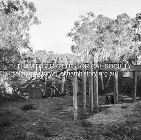
Negative - Photograph, J.A. McDonald, Eltham-Diamond Creek Road, May 1958
Bridge construction Eltham-Diamond Creek road over the Diamond Creek (Wattletree Road), Eltham, May 1958 Looking toward Eltham-Yarra Glen Road from Diamond Creek abutmentRecord of various Shire of Eltham infrastructure works undertaken during the period of 1952-1962 involving bridge and road reconstruction projects, sometimes with Eltham Shire Council Project Reference numbers quoted. It was during this period that a number of significant improvements were made to roads and new bridges constructed within the shire that remain in place as of present day (2022). In many situations, the photos provide a tangible visible record of infrastructure that existed throughout the early days of the Shire. The album was put together by or under the direction of the Shire Engineer, J.A. McDonald.1958-05, bridge construction, diamond creek (creek), eltham, eltham north, glen park bridge, infrastructure, shire of eltham, wattletree road bridge -
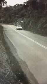
 Eltham District Historical Society Inc
Photograph, Old railway overpass, Sherbourne Road, Briar Hill
View of the railway bridge and road on Sherbourne Road / Para Road Briar Hill probably taken before the announcement of the construction of a new bridge in September 1963 (see Accession number: 01696-14) Black and white photograph printed with white borderssherbourne road, para road, briar hill, railway bridge -
 Eltham District Historical Society Inc
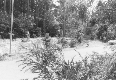
Album - Photograph, J.A. McDonald, Smiths Gully Road, Nov. 1952
November 1952 Smiths Gully Road between Hall and One Tree Hill RoadRecord of various Shire of Eltham infrastructure works undertaken during the period of 1952-1962 involving bridge and road reconstruction projects, sometimes with Eltham Shire Council Project Reference numbers quoted. It was during this period that a number of significant improvements were made to roads and new bridges constructed within the shire that remain in place as of present day (2022). In many situations, the photos provide a tangible visible record of infrastructure that existed throughout the early days of the Shire. The album was put together by or under the direction of the Shire Engineer, J.A. McDonald.infrastructure, shire of eltham, bridge construction, road construction, 1952-11, smiths gully, smiths gully road -
 Eltham District Historical Society Inc
Negative - Photograph, J.A. McDonald, Eltham-Yarra Glen Road, Lower Plenty, c. July 1962
View looking west across Old Eltham Road to the Eltham-Yarra Glen RoadRecord of various Shire of Eltham infrastructure works undertaken during the period of 1952-1962 involving bridge and road reconstruction projects, sometimes with Eltham Shire Council Project Reference numbers quoted. It was during this period that a number of significant improvements were made to roads and new bridges constructed within the shire that remain in place as of present day (2022). In many situations, the photos provide a tangible visible record of infrastructure that existed throughout the early days of the Shire. The album was put together by or under the direction of the Shire Engineer, J.A. McDonald.1962-07, eltham-yarra glen road, infrastructure, lower plenty, lower plenty road, road construction, shire of eltham, old eltham road -
 Greensborough Historical Society
Business card, Greensborough Road Surgery 2018, 2018_
Business card for a medical centre, Greensborough Road Surgery, at 520 Greensborough Road, Greensborough.Business card, teal blue card with white text and colour image.business cards, greensborough road surgery, greensborough road greensborough, medical centres -
 Greensborough Historical Society
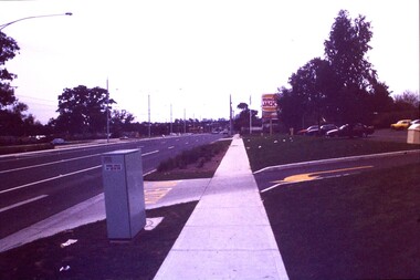
Slide - Photograph, John Ramsdale, Plenty Road: Slide 13, 1990s
Photograph shows a 3 lane road with Hungry Jacks sign - Plenty Road Bundoora.Part of the John Ramsdale collection of slides and audio visual material.Colour photograph scanned from slide.No maker's marks. No caption on slide.plenty road bundoora -
 Greensborough Historical Society
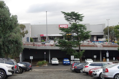
Photograph - Digital Image, Marilyn Smith, Carpark behind Savers, Para Road Greensborough, 18/06/2018
View of the carpark behind Savers Para Road Greensborough 2018. [284 Para Road]Digital colour photographpara road greensborough, savers -
 Ringwood and District Historical Society
Photograph, Looking south down Kubis Drive North Ringwood from near Oban Road 1982
Written on back of photograph, "31/4/82. Looking south down Kubis Drive from near Oban Road. Hubbard Reserve in background." -
 Ringwood and District Historical Society
Photograph, Looking west across Glenvale Road, North Ringwood from No.14 1982
Written on back of photograph, "21/4/82. Looking west across Glenvale Road from No.14 at what was once Keith Storey's property." -
 Mt Dandenong & District Historical Society Inc.
Photograph, 'Folly Farm' in Falls Road, Olinda 1914, 1914
Dr Leonard Bell Cox (1894-1976) was a noted neurologist and collector. He had a family cottage 'Folly Farm' at Olinda, the garden of which had input from Edna Walling. He moved permanently to 'Folly Farm' in 1962. In his glasshouse, he propagated and cultivated rhododendrons and camellias, and gathered rare species. He helped to form the National Rhododendron Garden at Olinda, providing many specimens from his beautiful garden. This photograph showing a group of people on the balcony of 'Folly Farm' was taken in 1914 and the cottage looks to have been newly built. The descriptive text on the reverse of this photograph was hand written by John Lundy-Clarke. Dr Cox’s “Folly Farm” Falls Road Olinda. Lot 19 Section 3 Village Settlement. Taken 1914 copied 1974 by J.L.C. folly farm, olinda, dr leonard bell cox, dr cox, edna walling, rhododendron garden -
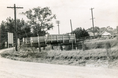
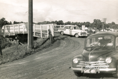
 Eltham District Historical Society Inc
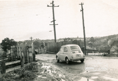
Photograph, Old railway overpass, Sherbourne Road, Briar Hill
View of the railway bridge, road and cars on Sherbourne Road / Para Road Briar Hill probably taken before the announcement of the construction of a new bridge in September 1963 (see Accession number: 01696-14) Black and white photograph printed with white borderssherbourne road, para road, briar hill, railway bridge -
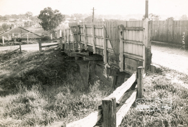
 Eltham District Historical Society Inc
Photograph, Old railway overpass, Sherbourne Road, Briar Hill
View of the railway bridge, road and cars on Sherbourne Road / Para Road Briar Hill probably taken before the announcement of the construction of a new bridge in September 1963 (see Accession number: 01696-14) Black and white photograph printed with white borderssherbourne road, para road, briar hill, railway bridge -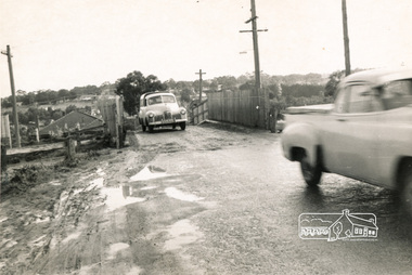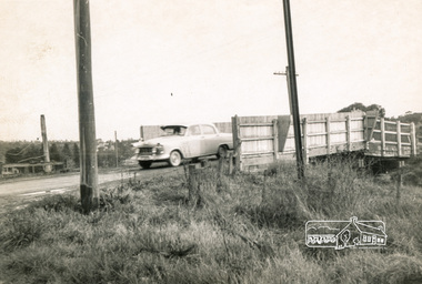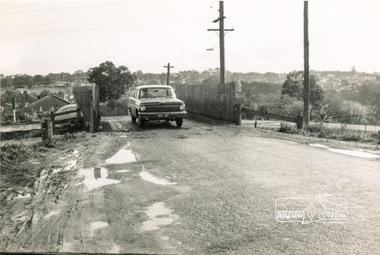
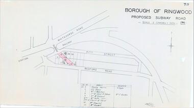 Ringwood and District Historical Society
Map, Borough of Ringwood, Victoria - Proposed Subway Road - 1943
Technical drawing by D.H. Oliver dated 22/9/43 showing residential lots affected by proposed road extending from Warrandyte Road railway underpass into Pitt Street and Bedford Road. Includes list of owners and occupiers of properties - Lot 4 Stanley Harris /R. Taylor, Lot 6 R.S. Sharp, Lot 7 William J. Wakeham, Lot 8 Janet R. Gibson /Mrs C. Burden, Lot 9 Mrs McClelland, Lot 10 part Mrs. Yetts, Lot 11 part 10 Church of Christ, Lot 54 Mrs Shwerkolt, Lot 55 Mrs Goodall.Scale: 2 chains = 1 inch. -
 Kew Historical Society Inc
Archive (Sub-series) - Subject File, Clarence House (180 Cotham Road), 1958
Various partiesReference, Research, InformationSecondary Values (KHS Imposed Order)Subject file containing a white metal badge “CLARENCE” from Clarence House girls’ school at 180 Cotham Road, Kew (Vic). An inscribed envelope accompanying the badge notes that: 180 Cotham Road, Kew. Built by Mr Justice A’Beckett. Later “Clarence House” school (a girls’ school) run by Misses Wymond. (This house was then owned but apparently not occupied by Jess and George Reed.)’clarence house - cotham road - kew (vic), schools -- kew (vic.)clarence house - cotham road - kew (vic), schools -- kew (vic.) -
 Greensborough Historical Society
Map, Melbourne and Metropolitan Board of Works. Survey Division, MMBW, Yarra 2500 / 14.27. Yarrambat, Yan Yean Road, 1978_04
Melbourne and Metropolitan Board of Works. Yarra 2500 [base map] 14.26. Yarrambat, Yan Yean Road. Parishes of Morang 3183 and Greensborough 2724. Municipality of Diamond Valley 257. Prominent streets include: Yan Yean Road, North Oatlands Road and Pioneer Road. Features include Yarrambat War Memorial Reserve.MMBW Map in 1:2500 [scale] series. Cream parchment with green tape reinforcing on edges and punched holes on left edge.mmbw, melbourne and metropolitan board of works, shire of diamond valley, whttlesea, yarrambat - maps -
 Phillip Island and District Historical Society Inc.
Photograph
One of a collection of over 400 photographs in an album commenced in 1960 and presented to the Phillip Island & Westernport Historical Society by the Shire of Phillip IslandPhotograph looking north along the old Main Road now Thompson Avenuelocal history, photography, thompson avenue, black & white photograph, thompson avenue cowes, phillip island, john jenner, bryant west -
Greensborough Historical Society
Leaflet, Road changes: Greensborough and Watsonia March 2019, 2019_03
Outline of proposed changes to the plan for roads around the Old Greensborough Road and Watsonia Station areas1 p. leaflet printed in colour both sides north east link, watsonia station, old greensborough road watsonia -
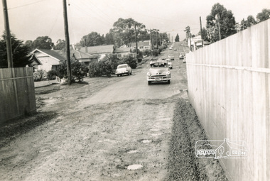
 Greensborough Historical Society
Photograph - Digital Image, St Helena Road Greensborough, late 1960s, 1960s
St Helena Road Greensborough in the late 1960s before residential development on south side of road.Digital copy of black and white photograph.st helena road greensborough -
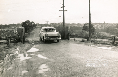
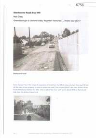 Greensborough Historical Society
Article and Photograph, Sherbourne Road Briar Hill c1954, 2017_
Information and photos of Sherbourne Road Briar Hill at around the time the road was widened, c1954-1958.This photograph and text was copied from a Facebook site. Members are people who lived in the Greensborough area and share their reminiscences of the area with others. The site is administered by a GHS member but is not officially affiliated with the Society. Any information is the opinion of the contributor. Article and photograph sourced from social media.sherbourne road briar hill, briar hill -
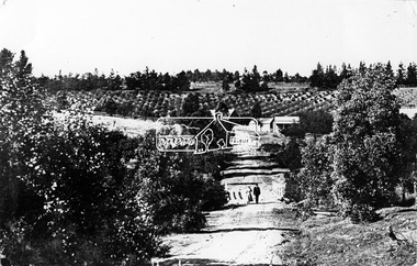 Eltham District Historical Society Inc
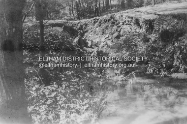
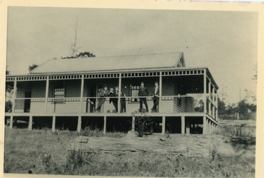
Photograph, Tom Prior, Research Gully Bridge, Research Gully Road, Research, c.1895
Research Gully Bridge. At time of collection (1970) Ingrams Road was formerly Research Gully Road.This photo forms part of a collection of photographs gathered by the Shire of Eltham for their centenary project book,"Pioneers and Painters: 100 years of the Shire of Eltham" by Alan Marshall (1971). The collection of over 500 images is held in partnership between Eltham District Historical Society and Yarra Plenty Regional Library (Eltham Library) and is now formally known as the 'The Shire of Eltham Pioneers Photograph Collection.' It is significant in being the first community sourced collection representing the places and people of the Shire's first one hundred years. The Reynolds family were early settlers in Research. The Reynolds/ Prior collection of photographs were taken by Tom Prior, the maternal uncle of Ivy Reynolds, around 1900 and the 60 photos in the album give a fine overview of many of the landmarks of Research and Eltham over 100 years ago. lvy lived in the family home for many years at 106 Thompson Cres Research. Ivy's father, Ernst Richard Reynolds and grandfather, Richard Reynolds, lived at the same address. Ivy's father Richard worked for Mr. Trail on his property in Research. Reynolds Road is named after the family. Mr Tom Prior (wife Eva) worked at the Melbourne zoo. He was very innovative and made his own camera, using the black cloth hood to exclude the light. The photographs are a reminder of the rural nature of Research and Eltham and its rich heritage.Digital imageshire of eltham pioneers photograph collection, research (vic.), ingrams road, research gully bridge, research gully road, aqueduct, reynolds prior collection -
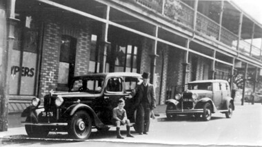 Surrey Hills Historical Society Collection
Photograph, Sunbury Crescent, Surrey Hills looking towards the corner of Union Road, 1930s, 1930
Date is approximate. This is one of a series of photos donated by Arthur Lyons. Lyons family history: Arthur's father, Fred Lyons initially worked for George Rea's cab service until he set up his own business. He started with a horse and hansom cab but in time he changed over to a motor vehicle and continued his service until 1960. Frederick Adolphus Lyons (1891-1980) was born in Surrey Hills, son of Thomas and Catherine Lyons. He married Elizabeth Ruby Hall in 1918. They lived at 55 Sunbury Crescent. The Lyons’ home in Sunbury Crescent was called ‘Knopshambury’ - this was probably a misspelling of Knockshanbally in Co Kilkenny, the birth place of Fred’s father, Thomas Edmund Josias Lyons (1846-1915). Arthur Lyons was born in Surrey Hills on 12 Jun 1920. He became a motor mechanic / welder and lived his whole life at 55 Sunbury Crescent. The donation was made while he was in hospital. He died shortly afterwards (23 Sep 1990). Donation was finalised by a neighbour, Mrs Florence Ann Armitstead, wife of Glen Victor Armitstead. Glen was a local hairdresser. They moved to 11 Sunbury Crescent after their marriage in 1939. Arthur had no relatives to distribute the material to. The buildings date from circa 1887 and extended some way down Sunbury Crescent. The address was 63 Sunbury Crescent on the corner of Union Road. Built by Albert Mills for the Premier Land Agency; taken over by Timothy Leigh in 1893. The building housed a variety of shops – initially the land agency, but later shops included at various times a fruiterer, florist, carpenter, fishmonger, upholsterer, plumber. However, by the time this photo was taken in the 1930s it was occupied by Triumph Press. The printing industry continued to have a lasting presence. Triumph Press was followed by Surrey Press and in 1970 New Life Publications moved to the site from Abbotsford. It was about this time that this original building was demolished to make way for a modern print works. Gradually the needs of the printing business absorbed other properties along the Union Road frontage. The boy in the photo is Arthur (Tiger) Lyons and beside him is Alf Johnson, the local printer. The Lyons family lived adjacent to these buildings at 55 Sunbury Crescent.Black and white photo of a section of double-storey terrace buildings in Sunbury Crescent Surrey Hills, taken looking towards the corner of Union Road. The bricks are two-toned and laid in herringbone pattern. The verandah on the 2nd story is filled in with cast-iron lacework panels. There are 2 vintage cars in front of the terrace. A young boy sits on the running board beside a man dressed in suit and hat. printers, vintage cars, sunbury crescent, victorian style, union road shops, arthur lyons, arthur frederick lyons, alf johnson, triumph press, surrey press, new life publications, timothy leigh,, albert mills -
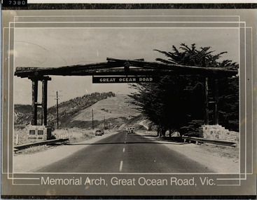 Lorne Historical Society
Photograph - Photograph of unidentified printed media, Memorial Arch Great Ocean Road looking south
A postcard or commercial picture of the Memorial Arch G.O.R Victoria. Shows view of road, cars and find view of Cypress Trees on seaward side of photograph. These trees are no longer there. -
Whitehorse Historical Society Inc.
Document, Broadbents Official Road Guide Central Victoria
Copy of cover and pages 154,155 from Broadbents Road Guide, Jubilee Edition including advertisement photos of Mitcham Motors, The Rendezvous Cafe, Mitcham and other advertisementsstreet directories, rendezvous cafe, mitcham, mitcham motors