Showing 8872 items matching " construction"
-
 Eltham District Historical Society Inc
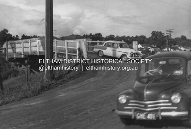
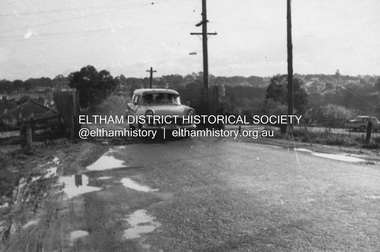
Photograph, R.J. Manuell, Old railway overpass, Sherbourne Road, Briar Hill, c. Sep 1963
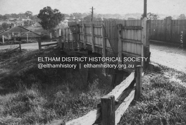
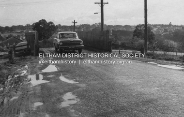
View of the railway bridge, road and cars on Sherbourne Road / Para Road Briar Hill probably taken around the time of the September 1963 announcement of the construction of a new bridge during the 1963-64 financial year. (see Accession number: 01696-14) Photo dating estimate: In a couple of photos of this series an EH Holden sedan is captured, registration HUL-309. Production of the EH Holden ran between August 1963 and February 1965. The bridge and roadway is also quite wet, typical of early springtime weather which also coincides with the news announcement dated September 4, 1963. Black and white photograph printed with white borders Negative black and white film 120 6x9 format (3 strips) duplicate copy made of print Agfa APX 100 sherbourne road, para road, briar hill, railway bridge -
 Eltham District Historical Society Inc
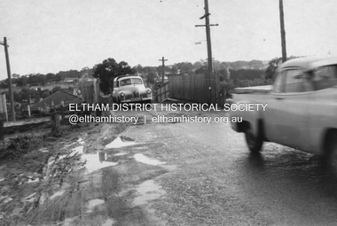
Photograph, R.J. Manuell, Old railway overpass, Sherbourne Road, Briar Hill, c. Sep 1963
View of the railway bridge, road and cars on Sherbourne Road / Para Road Briar Hill probably taken around the time of the September 1963 announcement of the construction of a new bridge during the 1963-64 financial year. (see Accession number: 01696-14) Photo dating estimate: In a couple of photos of this series an EH Holden sedan is captured, registration HUL-309. Production of the EH Holden ran between August 1963 and February 1965. The bridge and roadway is also quite wet, typical of early springtime weather which also coincides with the news announcement dated September 4, 1963. Black and white photograph printed with white borders Negative black and white film 120 6x9 format (3 strips) duplicate copy made of print Agfa APX 100 sherbourne road, para road, briar hill, railway bridge -
 Eltham District Historical Society Inc
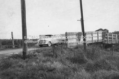
Photograph, R.J. Manuell, Old railway overpass, Sherbourne Road, Briar Hill, c. Sep 1963
View of the railway bridge, road and cars on Sherbourne Road / Para Road Briar Hill probably taken around the time of the September 1963 announcement of the construction of a new bridge during the 1963-64 financial year. (see Accession number: 01696-14) Photo dating estimate: In a couple of photos of this series an EH Holden sedan is captured, registration HUL-309. Production of the EH Holden ran between August 1963 and February 1965. The bridge and roadway is also quite wet, typical of early springtime weather which also coincides with the news announcement dated September 4, 1963. Black and white photograph printed with white borders Negative black and white film 120 6x9 format (3 strips) duplicate copy made of print Agfa APX 100 sherbourne road, para road, briar hill, railway bridge -
 Eltham District Historical Society Inc
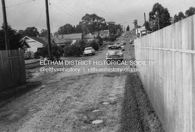
Photograph, R.J. Manuell, Old railway overpass, Sherbourne Road, Briar Hill, c. Sep 1963
View of the railway bridge, road and cars on Sherbourne Road / Para Road Briar Hill probably taken around the time of the September 1963 announcement of the construction of a new bridge during the 1963-64 financial year. (see Accession number: 01696-14) Photo dating estimate: In a couple of photos of this series an EH Holden sedan is captured, registration HUL-309. Production of the EH Holden ran between August 1963 and February 1965. The bridge and roadway is also quite wet, typical of early springtime weather which also coincides with the news announcement dated September 4, 1963. Black and white photograph printed with white borders Negative black and white film 120 6x9 format (3 strips) duplicate copy made of print Agfa APX 100sherbourne road, para road, briar hill, railway bridge -
 Melbourne Tram Museum
Photograph - Black and white - Glenferrie Road, Glenferrie c1915
Shows Glenferrie Road, near Linda St looking south, c1915 prior to the construction of the Railway overpass at Glenferrie Railway Station with H class tram 58 in the view. The tram line was constructed in 1913. It would appear that the level crossing gates are closed in the photograph. The building on the right-hand side by the horse-drawn cart was an ANZ bank until 2021. The closer building, a theatre (The Palace) has since been demolished and is now a Coles Supermarket. The level crossing was replaced with an overbridge in April 1916. The church in the background is the Immaculate Conception Church, without the spires - built after WW1. Yields information about the location, the streetscape and the tram, vehicles in use at the time. Black and white photograph of Glenferrie Road Glenferrie with tram H58, looking south near Linda St, c1915."RSCP 327" & "C1920s" in pencil on rear and H58 in red ink.tramways, trams, glenferrie road, hawthorn, streetscapes, h class, tram 58 -
 Melbourne Tram Museum
Newspaper, The Age Newspaper, "Trams crash, 31 hurt", 7-2-1989
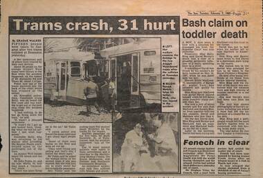
Reports on a significant rear on collision between two Z class trams, Z3 171 and another in Mt Alexander Road at Thorn Street Essendon. Gives details of the event. Story by Graeme Walker and Innes Willox and Age photographer Craig Abraham. In The Age, there is a second item about the rearrangement of Transport Departments - V-line, The Met into the Public Transport Corporation and the formation of the Roads Corporation from the Road Construction Authority and the Road Traffic Authority. Quotes Mr Kennan, Minister, Mr Brown Opposition spokesman and Peter Parkinson of Trades Hall. Item written by John Masanauskas.Yields information about an accident rear on in Mt Alexander Road Essendon and transport management rearrangements.Set of two newspaper clippings; 1 - "Trams crash, 31 hurt" - The Sun 7-2-1989 2 - "A painful end to tram journey" and "Left-wing wins in transport merger" - The Age 7-2-1989tramways, trams, mt alexander road, accidents, z3 class, tran 171, unions, amalgamation, management, the met, v-line, ptc, public transport corporation -
 Melbourne Tram Museum
Photograph - Set of 6 colour prints of trams at Corner of Flinders and Swanston Streets, George Bishop, c1999
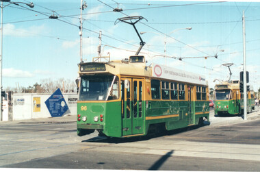
Set of six colour photographs of trams at the corner of Swanston and Flinders Streets. In the background can be seen the construction of the Federation Square project which commenced in 1999. 1 - Z 96 (Route 3, University) at Flinders and Swanston Streets. 2 - Z 37 (University route 5) 3 - SW6 888, City Circle, westbound. 4 - Z3 140 (East Coburg Route 1) - would appear that the car is not doing their hook turn properly 5 - B2 2037 westbound (Route 70, City Flinders St) 6 - Z 41 (Route 72, University)Yields information about the operation of Melbourne trams during the late 1990s.Set of six Colour prints printed on Kodak paperDetails of the photograph and photographer on the rear in ink.trams, tramways, z3 class, z class, tram 96, tram 37, city circle, tram 888, hook turns, tram 140, b2 class, tram 2037 -
 Eltham District Historical Society Inc
Photograph, R.J. Manuell, Old railway overpass, Sherbourne Road, Briar Hill, c. Sep 1963
View of the railway bridge, road and cars on Sherbourne Road / Para Road Briar Hill probably taken around the time of the September 1963 announcement of the construction of a new bridge during the 1963-64 financial year. (see Accession number: 01696-14) Photo dating estimate: In a couple of photos of this series an EH Holden sedan is captured, registration HUL-309. Production of the EH Holden ran between August 1963 and February 1965. The bridge and roadway is also quite wet, typical of early springtime weather which also coincides with the news announcement dated September 4, 1963. Black and white photograph printed with white borderssherbourne road, para road, briar hill, railway bridge -
 Kew Historical Society Inc
Article, The New Electric Tramway, Malvern to Kew
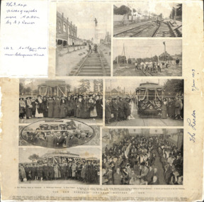
One of a group of photographs, including three within a published photo collage , taken by Edgar James Dower in the second decade of the twentieth century. Born and raised in Olinda, Dower later moved to Surrey Hills. He worked as an adult as a clerk in the city office of the Metropolitan Gas Company, and in his role as a 'collector', he was able to photograph scenes including the construction of tramlines, railways and associated buildings in Kew, Hawthorn, Camberwell and Surrey Hills. Later he established a real estate agency with his brother - the E.J. Dower Real Estate Agency, Mount Dandenong Office.The photo collage is an historically significant record of the development of transport infrastructure which was used to connect Victorians in the first two decades of the twentieth century. This development resulted from increases in population and the consequent extension of Melbourne's suburbs. The photographs, both individually and collectively, richly detail the labour of workers and the tools and machinery used to create and extend Melbourne's public transport network in the years preceding and during World War 1.Photo collage, published in The Leader newspaper in 1913, to commemorate the opening of the Malvern to Kew Tramway. The numbered photos are: 1. Kew Railway Gates at Glenferrie. 2. Burke Road Terminus. 3. Final Stages. 4. Ladies at the Official Opening. 5. The Acting Mayoress of Kew Cutting the Ribbon at the Kew Boundary. 6. Mayor and Councillors at the Kew Terminus. 7. The Cutting the First Ribbon. 8. Guests at the Hawthorn Town Hall.Inscribed in ink by Edgar J Dower top left: "The 3 top photographs were taken by E J Dower. No.3 Cotham Road Kew near Glenferrie Road"theme -- connecting victorians by transport and communications, theme -- travelling by tram -
 Melbourne Tram Museum
Audio - AV Presentation, Robert Green, "The Melbourne cable tramways - 1885 - 1940", 5/2008
Presentation by Robert Green to the Engineering Heritage Victoria, 22 May 2008 comprising a Powerpoint slides with the actual audio of the presentation. Gives the background to the establishment of the Melbourne cable tram system, its construction, operation, power or engine houses, and its replacement by electric trams or buses. Includes images of remnants of the former system in Abbotsford St North Melbourne, horse omnibuses, other cable tram systems, the grip, George Duncan, F B Clapp, the tramcars, cables or the rope, engine houses, St Kilda and passengers changing at Victoria St from electric to cable tram Demonstrates the work of Robert Green's research work into cable tram history and research and yields information about the history and development of Melbourne's cable tram network, the largest single operator network in the world.Digital Audio Visual Presentation of a lecture by Robert Green 2008 cable trams, melbourne, mtoco, trackwork, engine houses, tramcars, george duncan, f b clapp, horse buses, abbotsford st -
 Ithacan Historical Society
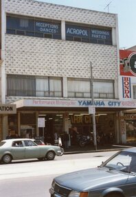
Photograph, Ithaca House, c1970s
Ithaca House, the home of the Ithacan Philanthropic Society, is located at 329 - 335 Elizabeth Street. The site was purchased in the mid 1950s to build the club rooms. The money for the venture was raised by the issue of non-redeemable 10 and 50 pound debentures to members. Nicholas Sofarnos, a young Ithacan architecture graduate, designed the building. Construction was completed in 1958. Up until 2020 Yamaha were long standing ground floor tenants. Prior to the building of Ithaca House, from 1917 up until 1958, the club rooms were located on the top floor of Michael's Building on the corner of Lonsdale and Elizabeth Streets. The Ithacan Philanthropic Society has been a focal point initially for expatriate Ithacans and as the years have passed it holds many happy memories for Australian born Ithacans through the generations.A coloured photograph of a three storey grey building in a city street with two cars being driven along the road. The Yamaha Motor Bicycle company occupies the ground floor, and in the adjacent building Honda motorbikes are sold. There are curtained windows across the width of the second floor and signage on the top floor windows indicates this level is used for social events such as receptions and dances. -
 Federation University Historical Collection
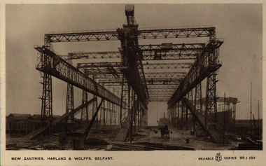
Postcard, Colour, Walton, New Gantries, Harland & Wolffs, Belfast, Ireland
Harland & Wolff Heavy Industries is a heavy industrial company, specialising in shipbuilding and offshore construction, located in Belfast, Northern Ireland. Harland & Wolff is famous for having built the majority of the ships intended for the White Star Line. Well known ships built by Harland & Wolff include the Olympic Class trio: RMS Titanic, RMS Olympic and RMS Britannic, the Royal Navy's HMS Belfast, Royal Mail Line's Andes, Shaw Savill's Southern Cross, Union-Castle's RMS Pendennis Castle, and P&O's Canberra. Harland and Wolff's official history, Shipbuilders to the World, was published in 1986.Two photographic postcards showing the new gantries, Harland & Wolffs, Belfast, Irelandchatham family archive, belfast, ireland, new gantries, harland & woffs -
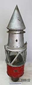 Flagstaff Hill Maritime Museum and Village
Functional object - Marine Navigation Light, Early 20th century
Breakwater navigation lights are placed at the end of the breakwaters to warn incoming vessels of the end of the structure, as a marine safety measure. The subject item was such a light believed to have been placed at the end of Warrnambool's breakwater around 1915 when it was extended. The light had remained in place for many years until it was probably removed when the structure was undergoing rock armouring repairs to the end of the breakwater in 1975. The light had been placed in a council storage shed probably from the time when the structure was undergoing these repairs in 1975. In 2014 the light was removed from the storage shed and donated to Flagstaff Hill museum. History: Warrnambool breakwater plans were drawn up by 1874 and approval was given for preliminary construction work to start but when the money ran out, the works stopped. With a number of quick changes of government the “Warrnambool” breakwater project was kicked from one Victorian state government to another. Then finally in 1879, the eminent British harbour engineer Sir John Coode was asked to design a breakwater. His first design was for a 1800 feet long structure but that was scaled back to 900 feet and construction finally began in 1884. This structure was attributed in causing major siltation of Lady bay, as a consequence the breakwater was again extended in 1915. In 1975, the rock armouring at the end of the breakwater was added but by 1979 another impact study was calling for the breakwater to be removed altogether. The Heritage Council Victoria, regard the Warrnambool breakwater is of historical significance to the state as one of the most important maritime engineering projects that was undertaken in Victoria during the late nineteenth century. The light is also as part of this structure regarded as a significant item of historical interest.Marker light or navigation light. Round light stand with conical top piece (2 separate pieces). Metal base painted red, clear glass middle section enclosed by metal frame, metal cone shaped top section painted silver. Electrical wiring can be seen inside centre section. Pole that light would have been on to elevate it is missing.Has metal plate screwed onto side of base engraved "23". flagstaff hill, warrnambool, shipreck coast, flagstaff hill maritime museum, maritime museum, great ocean road, warrnambool breakwater, marker light, naviagtion light, breakwater navigation light -
 Ballarat Heritage Services
Photograph - Colour, Bessibelle Drystone Sheep Wash, 2016, 24/04/2016
The Bessiebelle Sheepwashes and Yards complex is located on the former 14,000 acre Ardonachie Run, established in 1848 by pastoralist Samuel Gorrie, then carrying 6,000 sheep. In 1864 this run was subdivided into smaller runs, and the sheep washes were located within Mount Eccles and Lake Gorrie Run. The date of construction of the washes and walls is not known, although they were probably constructed within the period 1848-1864. The Bessiebelle Sheepwashes and Yards are probably the largest and most sophisticated surviving example of a traditional pastoral property sheepwash in Victoria. They clearly demonstrate the large network of races, yards and folds necessary for washing thousands of sheep over a short period of time. The Bessiebelle sheep washes apparently predate later technological changes and the necessity for hot water washing. The Bessiebelle sheepwashes and yards are of landscape significance as a cultural landscape which has been both modified by, and cleverly adapted to, an annual process that was of critical importance within the pastoral calendar. The drystone walls and races appear to evolve from the rocky terrain, and have a strong organic affinity with the prevailing harsh landscape. The drystone walls demonstrate a high level of craftsmanship and skill in their construction, and reflect the extensive scale of pastoral operations across the landscape. The Bessiebelle sheepwashes and yards are of archaeological significance to the State of Victoria. The site has not been fully surveyed but its complexity strongly suggests a potential to reveal more about the washing processes and associated pastoral occupation and activity in the area.(Heritage Victoria)drystone, bessibell, sheep race, sheep wash, agriculture -
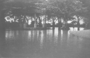 Port Fairy Historical Society Museum and Archives
Photograph
Showing the flood waters of 1946 around the Band Rotunda in the botanical gardens. Funding for the construction of the Rotunda was bequeathed in the Will of local resident Mrs Annie Williams, who was born in Daylesford in 1872 and died in Kew in 1930. Annie’s Will stipulated that the remaining value of her Estate be spent on erecting a Bandstand in the Port Fairy Botanical Gardens dedicated to the memory of her brother Hugh, a stretcher bearer in WW1 and who died in 1921 after being discharged with health issues, her husband Henry, and herself naturally. There is a plaque dedicated to Annie on the Bandstand She requested that the Bandstand be a replica of the one at Daylesford but by 1933 the value of her Estate had diminished to £76.4/8 which was insufficient to cover a similar design and the Borough Councillors felt it would be too extravagant for the Port Fairy Botanical Gardens. Local builder J.J.McLaren’s tender of £71.15/- was accepted and the octagonal concrete pillared construction was completed with the use of sustenance labour the following year. The Bandstand was opened in December, 1934 with a performance by the Port Fairy Band and local residents enjoying the entertainment and a picnic. In 1934 it was reported that there was some fuss in Council because of the whereabouts of the sum of approximately £3/- , being the amount left over from the build. After some months of debate, in which the Councillors suggested that the Engineer had used the money inappropriately, and to which he responded that the build had cost more than the quote, the matter seems to have ended there An image of the flood waters in the botanical gardens in 1946Black and white photograph of Flood water around rotunda in the gardensflood, river, botanical gardens, port fairy, moyne river, rotunda, bandstand -
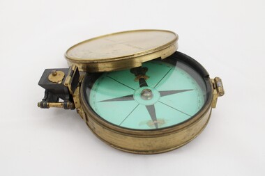 National Communication Museum
Equipment - Prismatic compass, Alfred E Sawtell, before 1872
After years of precursory surveying, debate and proposals the most ambitious civil engineering project of the day, the Overland Telegraph Line, began construction in September 1870. Superintendent of Telegraphs, Sir Charles Todd led the construction through “terra incognita,” guided by the precursory surveys of John McDowall Stuart and technologies such as his prismatic surveying compass. The unknown and hostile landscape claimed the lives of several men and scores of transport animals in the dogged pursuit of telegraphic connection to the rest of the world. Completed in August 1872, the Line connected Australia to the world via telegraph wires running 3,200 kilometres from Port Augusta in South Australia, to Darwin, then connecting via submarine cable to Java and beyond. The “earth [had been] girdled with a magic chain” according to the then Governor of New South Wales, Sir Hercules Robinson. How does it work? For use in surveying, the sight vane and prism are turned up on their hinge and the instrument is held horizontally either in the palm of one's hand or on a tripod. Two small discs of red and green glass attached to the prism can be flipped down over the sight line to reduce glare. The objective is to bring the subject into the sightline created by the prism, aligning with the thread of the sight-vane until the subject is bisected evenly. Once aligned, the division on the card may be read through the prism. This reading provides the magnetic azimuth, used for calculating the bearings of distant landmarks. Circular instrument mounted in a brass case with glass window and brass lid. The compass card face four black compass points printed on mint green paper; on the underside the magnetic needle would be affixed, all held in place by a brass knob at the centre. The arched labels of "Sawtell" and "Adelaide" and the Prince of Wales feathers appear to have been affixed with adhesive which has since yellowed in the areas of application on the compass card. The compass face is printed with numbers, every 10 degrees from 10 - 360, printed in reverse indicating this compass would have once held a mirror at the sighting bracket. On one side of the brass case is a brass hinged sighting-prism, possibly of ebonite. The sighting-prism is mounted in a hinged brass bracket on one edge of the brass case. It has two flip-type filter glasses (red and green) and folds down into a retracted travelling position. A hinged brass bracket on the opposite edge would have held the sighting bracket - carrying the sighting vane and mirror - which is now missing or removed. Under the hinge is a lever, possibly related to the movement of the bracket. Underneath the brass case is an indented circle with screw threads, possibly for attachment to a tripod, and indistinguishable marks scratched into the surface.Etched on to the centre of the lid, "Sawtell ADELAIDE / No 792." Affixed to the paper compass face, possibly from separate pieces of paper, "SAWTELL / ADELAIDE" with the Prince of Wales Feathers above "SAWTELL". Underneath on remains of white tape in red: "159."surveying, compass, charles todd, overland telegraph line, telegraph -
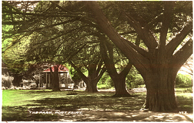 Port Fairy Historical Society Museum and Archives
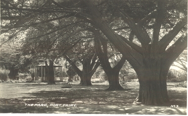
Postcard, The Park Port Fairy
Funding for the construction of the Rotunda was bequeathed in the Will of local resident Mrs Annie Williams, who was born in Daylesford in 1872 and died in Kew in 1930. Annie’s Will stipulated that the remaining value of her Estate be spent on erecting a Bandstand in the Port Fairy Botanical Gardens dedicated to the memory of her brother Hugh, a stretcher bearer in WW1 and who died in 1921 after being discharged with health issues, her husband Henry, and herself naturally. There is a plaque dedicated to Annie on the Bandstand She requested that the Bandstand be a replica of the one at Daylesford but by 1933 the value of her Estate had diminished to £76.4/8 which was insufficient to cover a similar design and the Borough Councillors felt it would be too extravagant for the Port Fairy Botanical Gardens. Local builder J.J.McLaren’s tender of £71.15/- was accepted and the octagonal concrete pillared construction was completed with the use of sustenance labour the following year. The Bandstand was opened in December, 1934 with a performance by the Port Fairy Band and local residents enjoying the entertainment and a picnic. In 1934 it was reported that there was some fuss in Council because of the whereabouts of the sum of approximately £3/- , being the amount left over from the build. After some months of debate, in which the Councillors suggested that the Engineer had used the money inappropriately, and to which he responded that the build had cost more than the quote, the matter seems to have ended there Coloured photograph (hand tinted) of the stand of cypress trees leading to the rotundaThe Park, Port Fairy - No. 3botanical, garden, cypress, tree, rotunda -
 Port Fairy Historical Society Museum and Archives
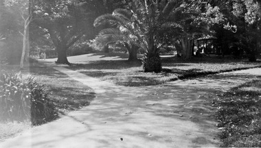
Postcard, "The Park", Port Fairy
Funding for the construction of the Rotunda was bequeathed in the Will of local resident Mrs Annie Williams, who was born in Daylesford in 1872 and died in Kew in 1930. Annie’s Will stipulated that the remaining value of her Estate be spent on erecting a Bandstand in the Port Fairy Botanical Gardens dedicated to the memory of her brother Hugh, a stretcher bearer in WW1 and who died in 1921 after being discharged with health issues, her husband Henry, and herself naturally. There is a plaque dedicated to Annie on the Bandstand She requested that the Bandstand be a replica of the one at Daylesford but by 1933 the value of her Estate had diminished to £76.4/8 which was insufficient to cover a similar design and the Borough Councillors felt it would be too extravagant for the Port Fairy Botanical Gardens. Local builder J.J.McLaren’s tender of £71.15/- was accepted and the octagonal concrete pillared construction was completed with the use of sustenance labour the following year. The Bandstand was opened in December, 1934 with a performance by the Port Fairy Band and local residents enjoying the entertainment and a picnic. In 1934 it was reported that there was some fuss in Council because of the whereabouts of the sum of approximately £3/- , being the amount left over from the build. After some months of debate, in which the Councillors suggested that the Engineer had used the money inappropriately, and to which he responded that the build had cost more than the quote, the matter seems to have ended there Black and white photograph of the stand of cypress trees with the rotunda in the backgroundThe Park Port Fairy - No 3botanical, garden, trees, rotunda, path -
 Port Fairy Historical Society Museum and Archives
Photograph
Funding for the construction of the Rotunda was bequeathed in the Will of local resident Mrs Annie Williams, who was born in Daylesford in 1872 and died in Kew in 1930. Annie’s Will stipulated that the remaining value of her Estate be spent on erecting a Bandstand in the Port Fairy Botanical Gardens dedicated to the memory of her brother Hugh, a stretcher bearer in WW1 and who died in 1921 after being discharged with health issues, her husband Henry, and herself naturally. There is a plaque dedicated to Annie on the Bandstand She requested that the Bandstand be a replica of the one at Daylesford but by 1933 the value of her Estate had diminished to £76.4/8 which was insufficient to cover a similar design and the Borough Councillors felt it would be too extravagant for the Port Fairy Botanical Gardens. Local builder J.J.McLaren’s tender of £71.15/- was accepted and the octagonal concrete pillared construction was completed with the use of sustenance labour the following year. The Bandstand was opened in December, 1934 with a performance by the Port Fairy Band and local residents enjoying the entertainment and a picnic. In 1934 it was reported that there was some fuss in Council because of the whereabouts of the sum of approximately £3/- , being the amount left over from the build. After some months of debate, in which the Councillors suggested that the Engineer had used the money inappropriately, and to which he responded that the build had cost more than the quote, the matter seems to have ended there Black and white photograph of gardens with dividing paths and palm treebotanical, rotunda, gardens, trees, bandstand -
 Parks Victoria - Gabo Island Lightstation
Insulators
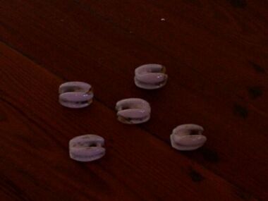
Modern communications technology arrived on Gabo Island with the construction of the telegraph line from Eden to Gabo Island in 1870. This type of insulator was usually used with radio antennae wires, telegraph and radio antennae equipment. The items of telegraphic equipment comprise a number of ceramic and glass insulators of varying age and type. Five, knuckle-shaped white glazed ceramic examples are associated with radio antennae wires. In addition to insulators, there is a telephone insulator bracket made of metal with wooden pins. It was once attached to the top of a steel pole and some of these remain in situ along the former telegraph line. Telegraphic communication commenced at the Gabo Lightstation in 1870, just eight years after the lightstation opened. The line from Sydney reached Eden, NSW by 1868 and was then extended to Gabo with the costs shared equally by NSW and Victoria. It was initially carried on posts across the sea to the island but was changed to a line along the seabed after the posts were washed away. The first telegraph office was a timber building on east side of the assistants’ quarters. In 1887 a new concrete telegraph office was built which included quarters for the operator, with Victoria and NSW sharing the construction costs. The 1992 CMP identified remnants of the line from its various phases of operation, and these can still be seen in 2016. Other ceramic insulators in the collection are associated with lines supported on utility poles for the transmission of high voltage electricity. .The various insulators have second level significance for their historic value and provenanceFive white glazed ceramic insulators. Knuckle bone sized, oval shaped with one opening at either end. All five are the same. -
 Parks Victoria - Gabo Island Lightstation
Insulators
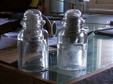
Modern communication tecnology arrived on Gabo Island with the construction of the telegraph line from Eden to Gabo Island in 1870. These and other cylindricial insulators were associated with the original 1870 copper wire telegraph line and later the P.M.G. line. The items of telegraphic equipment comprise a number of ceramic and glass insulators of varying age and type. Two bell-shaped insulators are made of clear glass, one with remains of wooden dowel inside. In addition to insulators, there is a telephone insulator bracket made of metal with wooden pins. It was once attached to the top of a steel pole and some of theseremain in situ along the former telegraph line. Telegraphic communication commenced at the Gabo Lightstation in 1870, just eight years after the lightstation opened.The line from Sydney reached Eden, NSW by 1868 and was then extended to Gabo with the costs shared equally by NSW and Victoria. It was initially carried on posts across the sea to the island but was changed to a line along the seabed after the posts were washed away. The first telegraph office was a timber building on east side of the assistants’ quarters. In 1887 a new concrete telegraph office was built which included quarters for the operator, with Victoria and NSW sharing the construction costs. The 1992 CMP identified remnants of the line from its various phases of operation,231 and these can still be seen in 2016. Other ceramic insulators in the collection are associated with lines supported on utility poles for the transmission of high voltage electricity. The various insulators have second level significance for their historic value and provenance1. Clear glass insulator. Cyndrical bottle shape with smaller dome -like knob on top. Hollow with inscription on lower edge. Has remains of wooden dowell inside. 2.Clear glass insulator. Cyndrical bottle shape with smaller dome -like knob on top. Hollow with inscription on lower edge.Around lower edge on opposite sides,"C.C / 42" -
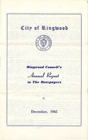 Ringwood and District Historical Society
Pamphlet, F.P. Dwerryhouse, Town Clerk and Treasurer, Ringwood Council's Annual Report To The Ratepayers - December 1965, 1965
City of Ringwood community information annual report for 1965, including sections covering Ringwood Planning Scheme, Extensions to Lionswood Village, Building Activity, Private Street Construction, Other Road Works, Drainage Works, Town Planning, Retention of Native Flora, General Rate Notice, Sanitary Service Charge, Dandenong Valley Authority Rate, Decimal Currency Conversion, Children's Playgrounds, Annual Special Clearance of Refuse, Garbage Removal, Immunisations, Infant Welfare Centres, Home Help Service, House Numbering, Dogs, Horse Riding, Fire Hazards and Burning Off, Secondary School Grants, and list of Council Representatives.rinx -
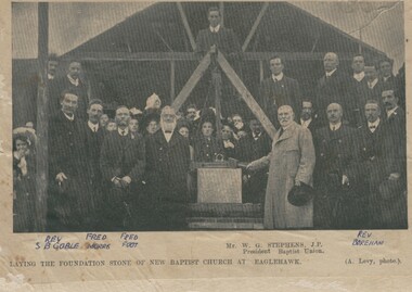 Bendigo Historical Society Inc.
Photograph - BAPTIST CHURCH, EAGLEHAWK
Black and white photograph. Group (outside) with building in background (under construction) and tripot/foundation stone with block and tackle in foreground. Inscriptions: on front - 'GP69', 'the foundation stone of the new Baptist Church at Eaglehawk (A. Levy, Photo). Names:: W.G. Stephens, J.P. President of Baptist Union (printed). Rev. S.G. Goble, Fred Morris, Fred Foot, Rev. Boreham (hand written in blue ballpoint pen). On reverse - Half of a photograph with inscription on statue 'to the Hon. Sir William John Clarke, Bart. LLD. MLC, Victoria's Tribute', 'RHSV stamp (GP69). History of object: Previous Acc. NO. GP69. Photograph Bendigo Advertiser 4.7.2000A Levyperson, group, baptist church, eaglehawk -
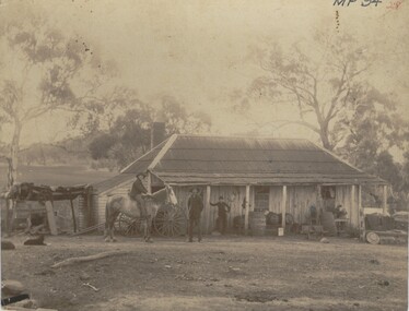 Bendigo Historical Society Inc.
Photograph - FARMHOUSE NEAR MT SUGARLOAF - SLAB HUT, c.1880
Sepia photograph. Slab hut with bark roof, verandah. One brick chimney, weatherboard skillion at L end. One male under verandah. One male in yard. One male mounted on horse. Barrels, wheelbarrow, four wheeled horse drawn vehicle under or near verandah. Inscriptions on front 'MP94', in red ballpoint ink '28'.On Back in grey lead 'Axedale family near Sugarloaf'.( near Fosterville ) On back in red ball point pen '28'. History of object: Previous Acc. No. 'MP 94'. An important photo of early settlers showing type and construction of farmhouse, type of farm implements and clothingBendigo Advertiserbuildings, residential, cottage -
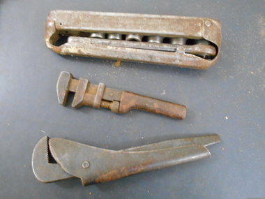 Bendigo Historical Society Inc.
Tool - PITTOCK COLLECTION: THREE WRENCHES
Pittock Collection : three wrenches, steel construction. Two individual wrenches: * one adjustable wrench , 230 x 80mm, made by the Footprint company, Sheffield, England. * one small (rusted) wrench, 165mm long; made by COES Wrench Co, Worcester, Mass. U.S.A. * One wrench set, for eight pieces (two smaller pieces missing) drop forged steel, made by The Keystone MFG, Co. Buffalo, U.S.A.; folded sheet steel ''case", rusted in places. Wrench 230 mm long x 40 mm wide x 60mm high. Items stored in coach builder's box, reference 13000.1.three wrenches manufacturers as noted -
 Old Castlemaine Schoolboys Association Inc.
Newspaper Clipping, Castlemaine Mail 11/10/1978
4 pages of newspaper. Articles include: Earth Stresses under studt Castlemaine Flour Mill Saveable - But who wants to save it? Melbourne Symphony Orchestra and Thompsons foundry band playing together Birth of Kirstyn Leanne Butterworth Birth of Tanya Louise Serpell Birth of Shane Daniel Brown Death of Robert Oscar Dodd Death of Betty Farrell Death of Lena Heritage Death of Peter James Megee SSW Advertising Allan Craig Baker Accident Peter Baker Accident Footpath Construction in forest, Duke and McGrath Streets Old Boys Reunion This Weekend Notice of AGM - Old Castlemaine Schoolboys Association castlemaine flour mill, melbourne symphony orchestra, thompsons foundry band -
 Ballarat Tramway Museum
Photograph - Colour Photograph/s, Carolyn Dean, 29/01/2000 12:00:00 AM
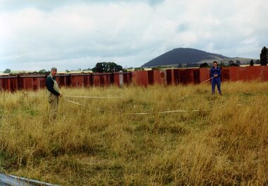
Set of seven colour photographs of initial work in the construction of the off site storage buildings at Bungaree. Taken by Carolyn Dean on 29/1/2000 and 30/1/2000. On Kodak paper. .1 > .3 on 29/1, rest 30/1 1347.1 - John Phillips and Alastair Reither setting out the foundations pegs. .2 - Foundation pegs in. .3 - ditto .4 - Mowing the grass (jungle) - John Phillips and Jim Parker. .5 - the sheep watching the grass go. .6 - the site from the south end. .7 - ditto from the north end.` See Fares Please! March 2000.All have on rear in black ink "29.1.00 or 30.1.00 / Photo by Carolyn Dean"bungaree, storage, btm -
 Ballarat Tramway Museum
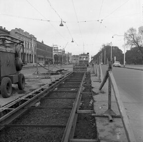
Negative, Geoff Grant, 19/06/1955 12:00:00 AM
Negative No. N326 and black and white print made by a laser printer (stored in folder ) of view looking along the new track in Nicholson St. Fitzroy, with W6 988 in background by the Exhibition Crossover. Photo shows nature of track construction at this portion of the future East Brunswick, Blyth St. line, an air compressor and the wood/metal barriers to protect roadworks in use at the time. Buildings along the east side of Nicholson St. in background, cable winding house at Gertrude St. can just be seen. Date of photo 19/6/1955. Negative scanned hi res and imaged updated 21/5/2020.trams, tramways, melbourne, nicholson st., east brunswick, track construction., tram w6 988