Showing 11008 items matching " land"
-
 Lorne Historical Society
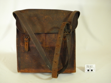
Functional object - Bag, circa1925
One of the toll bags used to collect tolls on the Great Ocean Road. First "Toll Gate" at Sunnymeade Estate as the road went through land owned by Mr C J Lane. Toll gates followed at "Stradbroke Point",later changed to "Stradbroke Knoll" named after the Govenor of Victoria, Lord Stradbroke, Grassy Creek and "The Springs". Mr W D McKay first toll keeper, then Mr & Mrs Wright. Toll commenced circa 1925 and ended 2nd October 1936. Cars were charged at 2/6 for car and driver and 1/- for each passenger. Motor cycles 2/-. Brown leather bag, with adjustable shoulder strap for carrying. Enclosed with a flap done up by 2 buckles.Hand scratched on front of bag:-"GREAT OCEAN ROAD TRUST".leather bag, toll gates, toll keepers, great ocen road -
 Greensborough Historical Society
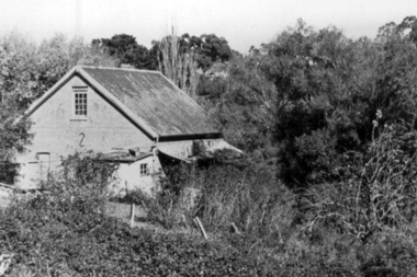
Photograph - Digital Image, Willis Vale, 1950c
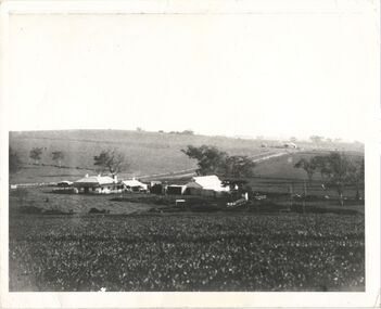
Willis Vale: House built by Edward Maygar, Robert Whatmough lived there mid 19th century and later sold to Partington family. It was located on the Plenty River at Partington's Flat Greensborough. Land use included farming and orchards. The derelict Willis Vale house was vandalized in 1964 and destroyed when a fire originating from North Plenty Gorge - Kurrak Road - was lit by two teenage boys and made its way several kilometres down to Partington's Flat Greensborough. This photo was taken after the Partington's moved house in 1947 across the river where Alan built their new Alwyn house that had access to electricity.Home of the Partington familyDigital copy of black and white photograph.willis vale, partington family, whatmough, maygar family -
 Greensborough Historical Society
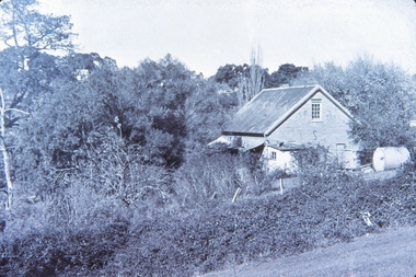
Photograph - Digital Image, Willis Vale, 1950c
Willis Vale: House built by Edward Maygar, Robert Whatmough lived there mid 19th century and later sold to Partington family. It was located on the Plenty River at Partington's Flat Greensborough. Land use included farming and orchards. The derelict Willis Vale house was vandalized in 1964 and destroyed when a fire originating from North Plenty Gorge - Kurrak Road - was lit by two teenage boys and made its way several kilometres down to Partington's Flat Greensborough. This photo was taken after the Partington's moved house in 1947; across the river where Alan built their new Alwyn house that had access to electricity.Home of the Partington familyDigital copy of black and white photograph.willis vale, partington, whatmough, maygar -
 Glenelg Shire Council Cultural Collection
Container - Ceramic Jar, 1850s
Found on shipwreck of 'Nene Valley' by an abalone diver some 10 years ago. Nene Valley was built in Durham, Sunderland, in 1852 – a typical merchant vessel of the era built for the colonial trade. In June 1854 Nene Valley left Gravesend, England, on its final voyage carrying nine passengers and cargo. On 19 October, the vessel grounded 15km northwest of Cape Northumberland after the crew mistook the land ahead for a cloud on the horizon. When they realised their mistake it was too late for evasive action. All passengers and crew evacuated safely, but the following morning four crew drowned after they returned to the vessel to cut away the masts.Ceramic jar, hand made, cream base with straight sides, tan stain colour to neck, flat bottom. Wide mouth opening (55 mm) Nene ValleyNene Valleynene valley, shipwreck, container -
 City of Moorabbin Historical Society (Operating the Box Cottage Museum)
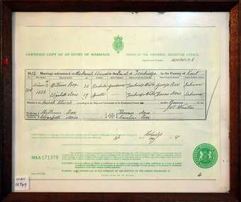
Document - Copy of Marriage Certificate William Box 1854, 14 May 1997
This copy of the Marriage Certificate of William and Elizabeth Avis-Box was obtained by CMHS member Dennis Maynard in May 1997. William Box and Elizabeth Avis Box came to Australia with his parents George and Mary Cripps-Box and siblings in 1856 William Box with his wife Elizabeth Avis Box and 13 children lived and farmed on the block of land in Jasper Road, East Brighton ( now McKinnon / Ormond) that was part of the Henry Dendy Special Survey 1841. Caroline Box, the eldest daughter of George and Mary Cripps-Box, remained in England working as a cook until she joined the family in Australia in 1863. William Box with his wife Elizabeth Avis Box and 13 children lived and farmed on the block of land in Jasper Road, East Brighton ( now McKinnon / Ormond) that was part of the Henry Dendy Special Survey 1841 Box Cottage Museum is the reconstructed pioneer cottage that William and Elizabeth lived in 1865 until they built a new house on the land. The Certified Copy of the Marriage Entry of William Box and Elizabeth Avis at the Parish Church, Tonbridge, Kent, England on November 13th 1854 in a wood frame with glass* CERTIFIED COPY OF AN ENTRY OF MARRIAGE / crest / GIVEN AT THE GENERAL REGISTER OFFICE / Application number C009059/0 / 1854 Marriage solemnised at The Parish Church of Tonbridge in the County of Kent / 206 / November 13th / 1854 / William Box 20 Bachelor Gardener / Elizabeth Avis 19 Spinster/ ………… Signed by William Box , Elizabeth Avis with Thomas Avis and Caroline Box as the Witnesses. Issued at Tonbridge 14th May 1997 MXA 171379 box william, box elizabeth avis, moorabbin, ormond, parish of tonbridge, farmers, dairy, market gardeners, pioneers, early settlers, kent, england, certificates, box caroline, avis thomas, -
 Orbost & District Historical Society
book, Hepburn, Dorothy, State School Number 3267 Lower Bendoc East Gippsland Victoria, C 2002
Located near the NSW border in the far east of Victoria, the Bendoc school served the needs of a rural population which opened the land to grazing at the turn of the century. It opened on September 8 1896. In December 1956 falling attendances forced the Education Department to close it. It is interesting to note that children here sought their secondary education in NSW. The first head teacher) was John M. Cass and the last R R King. In 1953-54 Lower Bendoc operated part-time with Goongerah. In 1955 it regained full-time status, but in 1956 worked part-time with Tubbut. Author, Dorothy Hepburn, attended Bendoc State School.This is a useful reference tool on the history of Bendoc.A spiral bound book with a plastic sheet front. The cover is white with black print and a b/w photo of a man sitting on a wooden chair outside a log building . Underneath is written "FROM HUMBLE BEGINNINGS TO FINAL CLOSURE".bendoc-state-school -
 Marysville & District Historical Society
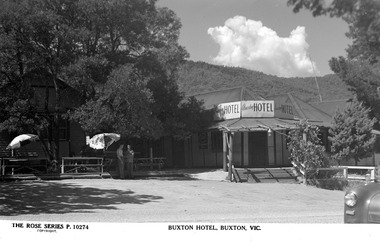
Postcard (Item) - Black and white postcard, Rose Stereograph Company, BUXTON HOTEL, BUXTON, VIC, 1913-1967
A black and white postcard of the Buxton Hotel in Buxton. The Buxton Hotel was built by William Burchall, probably in the late 1870s. The first owner, who also had land locally, was Frederick Nichols (1833-1904). The Buxton Hotel is located directly opposite the General Store. It was fronted with two huge oak trees and bordered and backed by large pine trees. It was a weatherboard structure with a painted corrugated iron roof. Old split wood shingles were covered by corrugated iron, which overlaid the shingles to make the roof watertight. The wooden shingles date back to the 1850s. This postcard was produced by the Rose Stereograph Company as a souvenir of Buxton.A black and white postcard of the Buxton Hotel in Buxton.THE ROSE SERIES P. 10274/ COPYRIGHT BUXTON HOTEL, BUXTON, VIC.buxton, victoria, australia, buxton hotel, rose stereograph company, rose series, p. 10274, postcard, souvenir, william burchall, frederick nichols -
 Marysville & District Historical Society
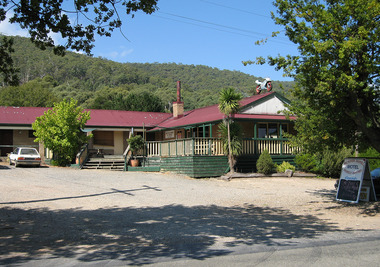
Photograph (Item) - Colour photograph, Unknown
A digital copy of a colour photograph of the Buxton Hotel in Buxton. The Buxton Hotel was built by William Burchall, probably in the late 1870s. The first owner, who also had land locally, was Frederick Nichols (1833-1904). The Buxton Hotel is located directly opposite the General Store. It was fronted with two huge oak trees and bordered and backed by large pine trees. It was a weatherboard structure with a painted corrugated iron roof. Old split wood shingles were covered by corrugated iron, which overlaid the shingles to make the roof watertight. The wooden shingles date back to the 1850s. This postcard was produced by the Rose Stereograph Company as a souvenir of Buxton.A digital copy of a colour photograph of the Buxton Hotel in Buxton.buxton, victoria, australia, buxton hotel, accommodation, photograph, william burchall, frederick nichols -
 City of Moorabbin Historical Society (Operating the Box Cottage Museum)
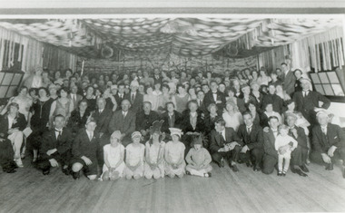
Photograph , Black & White Opening McKinnon Progress Hall c 1925, c1925
McKinnon was a small community in East Brighton settled mainly by market gardeners but it had a State School, Churches, a hotel opened by Thomas Bent's father, Post Office and some shops. After WW1 land close to the railway line began to be sold and new homes and various shops were built. A Progress League was well supported and new hall built. McKinnon Rd Shopping precinct did not prosper as expected and some attribute this to the failure to secure the Hoyts picture theatre c 1925. Hoyts instead built the theatre in Centre Rd Bentleigh and this took a lot of trade away from the shops in McKinnon Rd.McKinnon was settled by market gardeners and after the train line arrived more houses and shops were built so that the small community developed through the 20thCBlack & White photograph showing the crowd of local residents celebrating the opening of the McKinnon Progress hall c1925mckinnon progress league, mckinnon railway station, ormond state school, hoyts picture theatres, centre road bentleigh, wyles jim, mckinnon hotel, gardeners arms hotel, bent james, smith j l; smith , chaff cutter, horse drawn carts, toll gates brighton, motor cars 1900, steam engines, early settlers, bentleigh, mckinnon, parish of moorabbin, city of moorabbin, county of bourke, moorabbin roads board, shire of moorabbin, henry dendy's special survey 1841, were j.b.; bent thomas, o'shannassy john, king richard, charman stephen, highett william, ormond francis, maynard dennis, market gardeners, vineyards, orchards -
 Victorian Interpretive Projects Inc.
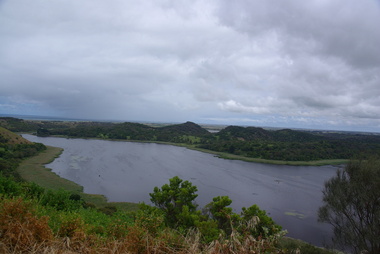
Photograph - Colour, Clare Gervasoni, Tower Hill, Victoria, 2013, 2013
The Tower Hill Reserve is located inside a dormant volcano, and features a lake and wetlands. It became Victoria's first national park in 1892, but by the 1930s the early settlers had cleared much of the land for grazing, cropping and quarrying. In the 1960s the bare hills and islands were revegetated based in species identified from Eugene von Guerard's painting of Tower Hill. Tower Hill was formed around 30,000 years ago in a violent volcanic eruption. The initial eruption created the outer rim of the volcano, and later smaller eruptions formed the internal hills that are evident today. The layers of volcanic ash layers include artefacts relating to indigenous communites.A series of colour digital photographs showing Tower Hill, near Port Fairy, Victoria. Tower Hill is an extinct volcano.tower hill, volcano, extinct -
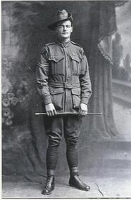 Lake Bolac & District Historical Society
Black and white photograph, Private Louis (Joe) Murdoch Murray, 8th Lighthorse regiment, WW1
Private Louis (Joe) Murdoch Murray, 8th Light Horse Regiment, WW1. Joe enlisted 15/01/1915 and embarked for overseas on 07/05/1915. He served at Gallipoli and in France where he was badly wounded at the battle of Ypres in 1917. After returning from the war he took up farming on land donated to him by the Austin family. However, he never fully recovered either physically or mentally from his war service and lost his farm in the Depression. He spent his final years in an Old Soldiers Home in Frankston. He is buried in Melbourne.murray, 8th light horse regiment, ww1, gallipoli, ypres, austin, old soldiers home - frankston, melbourne. -
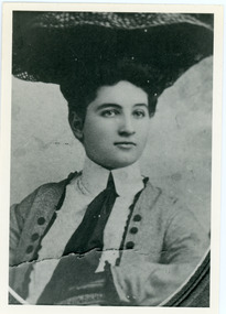 Mt Dandenong & District Historical Society Inc.
Photograph, Doris Child
John Lundy-Clarke grew up in the Kalorama/Mt Dandenong area and later in life (1972-74) began to write a comprehensive history of the area working from an original settlement map in an effort to cover all areas. William Lucas , who came from England to visit Matthew Child in the late 1870s. He purchased land from Matthew and married his daughter Catherine. They developed their property as the sporting lodge 'Glenrivers'. Their daughter Dorothea was born in 1888. She was an accomplished horsewoman who married her cousin Charles Percival (Percy) Child in 1917. Percy worked a sawmill on the creek .Black and white copy of studio portrait of Doris (Dorothea) Child (nee Lucas).Handwritten by John Lundy-Clarke on reverse: Doris Lucas “Dorothea?” Daughter of W Lucas and Catherine nee Child. Wife of Percy Child. Mother of Lois. Born 1889 died 1936 (?)dorothea lucas, dorothea child, percy child, matthew child, william lucas, catherine child -
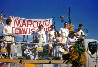 Bendigo Historical Society Inc.
Slide - Back to Marong Celebrations, c1960-1963
Marong was first incorporated as a road district on 27 August 1861, and became a shire on 23 December 1864. On 1 October 1915, the Borough of Raywood, which was gazetted on 17 January 1865 on 23.31 square kilometres (9.00 sq mi) of land 28 kilometres (17 mi) north of Bendigo,[2] was united with Marong. On 1 October 1990, the Shire of Marong became a rural city, under the Local Government Act 1989. On 7 April 1994, the Rural City of Marong was abolished, and along with the City of Bendigo, the Borough of Eaglehawk and the Shires of Huntly and Strathfieldsaye, was merged into the newly created City of Greater BendigoTwelve slides taken for the Back to Marong celebration about 1960-63 possibly at the Marong Recreation (Football) ground. Slides include a float with members of the marong tennis club, a family group, a float depicting old school days, horse and carts, ladies and men dressed in period costumes and Miss 'Golden North'.history, bendigo, back to marong, city of greater bendigo, rural city of marong, marong tennis club, carl tracey collection -
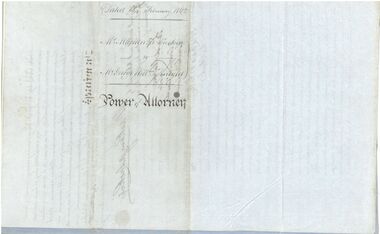 Bendigo Historical Society Inc.
Legal record - Power of Attorney, 18/02/1862
Captain Mackenzie Luckie was born in 1821. From 1853 he commanded eight ships. He died on board the Michael Angelo off the coast of New Zealand in February 1875. After the ship arrived in Nelson, The Argus (Melbourne) reported on 12 February 1875 that Captain Luckie was found dead in his cabin, from heart disease. His appointed Attorney Mr George William Knight selected land in Sunbury in 1860 and then arrived in Bendigo on 2 April 1870. For more information about George William Knight see https://trove.nla.gov.au/newspaper/article/227853797?searchTerm=george%20william%20knightCaptain McKenzie Luckie a. Document appointing George William Knight of Sunbury or elsewhere in the Colony of Victoria as a lawful attorney to act for Mackenzie Luckie of 15 Tredegar Square, Bow in the County of Middlesex (now London), Master Mariner. Dated 18 February 1862. Witnessed by William Charles White. Five page document - two blue flimsy sheets, one light card sheet and two grey flimsy sheets. b. Transcript from The Age (Melbourne) 27 November 1937. The letter from H. Daniel, Monte Video, South America, is responding to an earlier letter from the grand daughter of Captain Mackenzie Luckie. It includes a record of the career of Captain Luckie from 1853. captain mackenzie luckie, master mariner -
 Kew Historical Society Inc
Photograph, Kilby Farm, Kew East
Kilby Lodge (c.1845-c.1922). William Oswin purchased Crown Land Lots 52 & 53 in 1845. These lots ran north from an old bullock track [later Kilby Road] to the Yarra, and east to Burke Road. Oswin purchased a neighbouring Lot in 1851, separated by the bullock track from the rest of the farm. Oswin built ‘Kilby Lodge’ and, with his brother, farmed dairy cattle on the site. Oswin’s descendants owned the farm into the 1890s. New subdivisions of Kilby and neighbouring farms in the 1920s changed the rural nature of north Kew. Housing and large recreation reserves replaced dairy farms and market gardens. This work forms part of the collection assembled by the historian Dorothy Rogers, that was donated to the Kew Historical Society by her son John Rogers in 2015. The manuscripts, photographs, maps, and documents were sourced by her from both family and local collections or produced as references for her print publications. Many were directly used by Rogers in writing ‘Lovely Old Homes of Kew’ (1961) and 'A History of Kew' (1973), or the numerous articles on local history that she produced for suburban newspapers. Most of the photographs in the collection include detailed annotations in her hand. The Rogers Collection provides a comprehensive insight into the working habits of a historian in the 1960s and 1970s. Together it forms the largest privately-donated collection within the archives of the Kew Historical Society.A panoramic photograph of Kilby (or Oswin's) Farm in East Kew."Kilby Farm when Oswins owned it. Commenced 1845."kilby farm, kilby lodge, william oswin, dorothy rogers, kew east -
 Surrey Hills Historical Society Collection
Painting, Muriel Pornitz (Pornett), "The old quarry" by Muriel Pornitz, 1927
The waterbody was the site of a quarry that existed between Grovedale Road and James Street, Surrey Hills on land owned by J B Maling (senior). Clay from it was used to make bricks for local houses. The quarry became a hazard and after several drownings was filled in. The Grovedale Park now occupies the site. Muriel Hedwig Lucy Pornitz, also known as Muriel Pornett, lived locally. She was born in Melbourne in 1894 and studied at the South Australian School of Arts & Crafts in 1911 under James Ashton and Fred Britton, and at the Australian School of Etching in Sydney. She was also an illustrator and cartoonist. She died in 1982.A small oil painting on canvas board in a dark wood frame of a water body with a clay bank behind and 2 trees above the bank. Lower front right hand corner: "AUST. M P 1927" On the rear upper edge, in ink on badly degraded brown paper backing: " "The Old Quarry" Surrey Hills, Melb." / [Second line of writing is illegible.] A label is stuck to the middle section of the paper backing. It indicates that the painting was framed by Toska Art Studio (N. Cl Colliver, Proprietor) of wyndham Street, Shepparton. Lower rear edge, in ink on badly degraded brown paper backing: "by / Muriel ...... / "Darnok", / 22 Grovedale Rd / Surrey Hills, Melb" painting, grovedale road quarry, quarry, grovedale road park, john butler maling (snr), surrey hills, muriel pornitz, muriel pornett -
 The Beechworth Burke Museum Research Collection
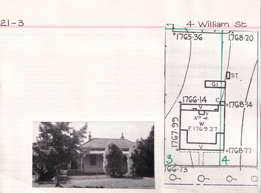
Card (Series) - Index Card, George Tibbits, 4 William Street, Beechworth, 1976
George Tibbits, University of Melbourne. Faculty of Architecture, Building and Town & Regional PlanningIndex system that support the research for Beechworth : historical reconstruction / [by] George Tibbits ... [et al]Arranged by street names of BeechworthEach index card includes: street name and number of property, image of property, allotment and section number, property owners and dates of ownership, description of the property according to rate records, property floor plan with dimensions.beechworth, george tibbitsbeechworth, george tibbits -
 Mordialloc College Alumni Association Inc (MCAA)
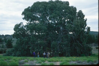
Photograph, 1979 Wyperfeld Old Be-al River Red Gum Tree, 1979
1979 - Mordialloc-Chelsea High School students standing in front of “Old Be-al” in Victoria’s Wyperfeld National Park, near Outlet Creek. It has been described as one of the most magnificent River Red Gums in the land. This glorious tree with foliage hanging to the ground escaped the fire of 1959 but not the fire of 1982 that damaged it badly. It lives on but has also suffered from lack of water and is now inaccessible to the public in a reference area. The MCAA has provided this image to the Friends of Wyperfeld National Park. Mordialloc-Chelsea High School students visited the Wyperfeld National park annually for the biology and geography Year 11 school camp.Example of a River Red Gum at Wyperfeld National Park.Digital image reproduced from colour slide.big desert fire 1959, mordialloc-chelsea high school camp, wyperfeld national park, fire 1982, old be-al river red gum -
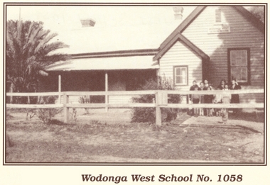 Wodonga & District Historical Society Inc
Photograph - Wodonga West School No. 1058
Wodonga West School opened on 24 January 1870 and closed on 9 May 1950. It was located near the current intersection of McKoy Street and the Hume Freeway in West Wodonga on land donated by J.W. Klinge. The school replaced an older school, “Green Hills School, which was located north of the railway line. A public telephone was installed at the school and the mail service operated from the school three days each week. In 1935 a row of 15 ornamental trees was planted along the boundary fence, one for each of the pupils at the school. When this school closed the nine remaining students were transferred to Wodonga Primary School.This image is significant because it documents the early developments in the provision of education in Wodonga, Victoria A black and white photo of a group of children standing outside the Wodonga West School building.wodonga schools, wodonga west primary school, education wodonga -
City of Kingston
Photograph - Colour, 29 January 1993
Bonbeach is a small beachside suburb located between Chelsea and Carrum. The station was opened in 1926 and was the last to be established in the group from Aspendale to Carrum. Urban growth began after World War II. State primary and high schools were opened in 1958 on land in Breeze Street that was once occupied by The Australian Glass Manufacturers. Immediately east of the school sites is the Patterson River Golf Club. The Bonbeach sports reserve has five ovals and is home to the Bonbeach football and baseball clubs. The suburb borders the Edithvale-Seaford Wetlands which is the remnant site of the Carrum Carrum swamp, once the home of the Bunurong people.Bonbeach was originally a seaside destination for holidaymakers and the housing comprised of holiday homes and gradually more permanent residents. It was not until 1926 that Bonbeach had its own railway station. From 1906 until the late 1940s sand was quarried on the east side of the railway line and used in the manufacture of glass. The Australian Glass Manufacturers sold this land in residential blocks and Bonbeach's permanent population spread from the coastal strip across to the other side of the railway line. Laminated colour aerial photograph of the suburb of Bonbeach and also the southern section of neighbouring Chelsea within the City of Kingston. The extent of this 1993 aerial image includes: Top left - Maury Road at the south end of the Chelsea shopping Centre; Top right - Scotch Parade Chelsea Bottom left - Monica Avenue in Bonbeach; Bottom right - Patterson River Golf Club. Landmarks include St Joseph's Church and Primary School, Chelsea Primary School, Bonbeach Station, Bonbeach Fotball Club sports playing fields and Bonbeach Life Saving Club. The Edithvale Wetlands is featured prominently to the right-hand side of the image. Black typed writing on white adhesive label: No. 6662 Black typed writing on white adhesive label: 26E/6662, 29/1/93, 4.25 pm Black typed writing on white adhesive label: 29-1-93 Black typed writing on white adhesive label: P000109 Circular yellow adhesive sticker bonbeach, chelsea -
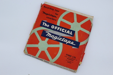 Melbourne Legacy
Audio - Recording, tape, Melbourne Legacy, 1956
An audio recording from 24 April 1956. The tape has not been played. From the date it could be a recording of the annual "Anzac Commemoration Ceremony for Students" event, usually held just prior to Anzac Day. The ceremony provides a valuable opportunity for students to gain an appreciation of the Anzac spirit, the significance of the Shrine and the meaning of Anzac Day. Inscription starts with 'Shrine Ceremony', 'Commentator L/ W Scott', also 'Governor Sir Dallas Brooks', 'Land of mine', 'Pres L/ R Gaylard'. Legatee Gaylard was president in 1956. The Governor of Victoria was patron of Legacy at the time and attended many ceremonies and events.A record of a ceremony at the Shrine run by Legacy for students.An audio tape, 90 mins, on a clear plastic spool in a red cardboard box.Box, Recording tape for magictape recorders,Pyrox LTD. 14-36 Queensberry St. Melbourne 18 Albion St. Sydney Sound- recording Tape 60 minutes twin track. For use with magictape recorders.All in blue print The Official Magictape in white print on a dark blue background. Title Melbourne Legacy,speed 7 1/2" per sec, in blue biro. Various recordings listed with times in blue ink. Spool. Side no1, side no 2, Magictape made in Australia. Tape. anzac commemoration for students, governor of victoria -
Eltham District Historical Society Inc
Folder, James Johnston
"Johnston, James - Kangaroo Ground, is a scotchman by birth, born in Aberdeenshire in 1812. Arriving in Melbourne in 1840, and spending twelve months on the Plenty, and another similar period on the Darebin Creek, he went in 1842, to the Kangaroo Ground, where he rented a farm from Mr Donaldson for seven years, subsequently purchasing 160 acres of land from the Government at one pound 13s per acre, and also owning 60 acres adjoining, where he carries on farming. Mr Johnston has a family of three sons and four daughters." Sutherland, Alexander Victoria and its Metropolis, v.2 1888 page 434. Folder of information on James Johnston, Kangaroo Ground pioneerjames johnston, pioneer, kangaroo ground -
Bialik College
Mixed media (series) - Sites & Premises: fundraising appeals and plans for development
1990s, 2000s, 1980s, buildings, development, planning, shakespeare grove, elc, 1970s1990s, 2000s, 1980s, buildings, development, planning, shakespeare grove, elc, 1970s -
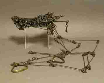 Federation University Historical Collection
Instrument - Survey Chain, Chesterman, Gunter's Survey Chain
Before metric measurement was introduced land was measured in chains and links. The chain was a precision part of a surveyor's equipment. It required frequent calibration, yet needed to be sturdy enough to be dragged through rough terrain for years. A standard survey chain is 66 feet (or 20.117m) long and made up of 100 links. Each link is 7.92 inches (approximately 201mm) long, measured from the inside of the loop. The handles are for tensioning the chain in use, they are not part of the length of the chain. In pre-metric units, there were 80 chains to 1 mile (equals 1.609km) This surveyor’s chain has an 8-inch link pitch, with markers at 10 link intervals. This metal surveyor’s chain (or Gunter's Chain) has an 8-inch link pitch, with markers at 10 link intervals, and handles at either end. A Surveyor’s Chain was 66 feet long, and made up of 100 links connected by two rings. A link in measurement includes the two rings at each end. gunter's chain, survey chain, surveyor s chain, perch, rood, surveying -
 Eltham District Historical Society Inc
Photograph, Fay Bridge, Clifton Pugh's Artists' Colony, Dunmoochin, Barreenong Road, Cottles Bridge, c.1995
Visit to Dunmoochin prior to Clifton Pugh's home being destroyed by fire in 2002. Following military service in the second world war, Clifton Pugh studied under artist Sir William Dargie at the National Gallery School in Melbourne as well as Justus Jorgensen, founder of Montsalvat. For a while he lived on the dole but also worked packing eggs for the Belot family saving sufficient to purchase six acres (2.4 ha) of land at Barreenong Road, Cottles Bridge. He accumulated more land and persuaded several other artists and friends to buy land nearby, resulting in a property of approximately 200 acres, stablishing it as one of the first artistic communes in Australia alongside Montsalvat in Eltham. It was around 1951 that Pugh felt he had '"done moochin' around" and so the name of the property evolved. He bought timber from Alistair Knox to build his house on the crest of a hill. Inspired by local goldminer's huts, it was a one room wattle-and-daub structure with dirt floor. Over the years it expanded with thick adobe walls made from local clay, high ceilings and stone floors. All materials other than the local earth were sourced from second hand materials, most found at wreckers' yards. Artists from across the nation were drawn to Dunmoochin, with several setting up houses and shacks on the property, maintaining their independence but sharing their artistic zeal. Artists who worked or resided at Dunmoochin included Mirka Mora, John Perceval, Albert Tucker, Fred Williams, Charles Blackman, Arthur Boyd and John Olsen. In 2002, Pugh's house along with its treasure trove of art and a library of some 20,000 books was destroyed by fire. Traces of Pugh's home remain with the presence of the Victorian doorframe archway with leadlight of intricate design, procured from a demolished Melbourne mansion; and two bronze life-sized female statues created by Pugh and cast by Matcham Skipper. In place of Pugh's house rose two double-storey mud-brick artists' studios topped with corrugated iron rooves curved like the wings of a bird with accommodation for seven. The original studios, gallery and other buildings survived the fire.fay bridge collection, 1995, barreenong road, cottles bridge, dunmoochin -
 Eltham District Historical Society Inc
Opening of Meruka Childcare Co-operative, Meruka Park, 5 Meruka Dr, Eltham, April 1994
In 1919 J.B. North, a violinist with the then Melbourne Symphonic Orchestra, and Monsieur Leon Lambert, a French architect, who later designed the Glaciarium Ice Skating Rink, purchased three available farms, Looker's, Wright's and Taylor's, approximately 60 acres, the area running along the creek and being bordered by the present day Ryans Road, Karingal Drive and Sherbourne Road. The farms were used for orchards and market gardens. Leon Lambert designed and built two homes on the farm site, one for the North family, ‘Tralford’, and the other, ‘Glen Ellen’, for himself and his wife. The homes were considered as "brother and sister" and they each included in their design an identical bay window in the main living area. "Glen Ellen" originally comprised kitchen, lounge room, inglenook, dining room, bath room and sleepout. Although the home has been extended over the years, much of the original architecture has been retained including timber panelling and three fireplaces. The land was subdivided in approximately 1966 with "Glen Ellen" retaining approximately one half acre of land fronting Meruka Drive. The property then passed from the Charleston family to Gerald and Margaret Sutton in 1976 and again was sold in 1980 and lastly sold again in 1994. The Norths named their house 'Tralford'. According to Marjorie North, the name Meruka was suggested by Alan Gardner and so was apparently not used by the North family. The name appears to be of Indian origin and its connection with the land is not known. ‘Tralford’ stayed in the North family for many years. Eltham Council acquired the house to create Meruka Park. The house was used for some years by the Council as a community arts facility and as emergency accommodation. It fell into disrepair and was demolished about 1990. The Meruka Child Care Centre has been built on the site and incorporates some of the architectural features of the old house. The Co-op was opened in April 1994. The original drive flanked by large old cypress trees remains. These trees are considered to be of local heritage significance and for this reason Meruka Park is covered by a Heritage Overlay under the Nillumbik Planning Scheme. Part of the park has been preserved as habitat for rare local flora. LL's house, named ‘Glen Ellen’, remains in a well-preserved state and fronts Meruka Drive.cr pam sladden, eltham, meruka child care co-operative, meruka house, meruka park -
 Eltham District Historical Society Inc
Opening of Meruka Childcare Co-operative, Meruka Park, 5 Meruka Dr, Eltham, April 1994
In 1919 J.B. North, a violinist with the then Melbourne Symphonic Orchestra, and Monsieur Leon Lambert, a French architect, who later designed the Glaciarium Ice Skating Rink, purchased three available farms, Looker's, Wright's and Taylor's, approximately 60 acres, the area running along the creek and being bordered by the present day Ryans Road, Karingal Drive and Sherbourne Road. The farms were used for orchards and market gardens. Leon Lambert designed and built two homes on the farm site, one for the North family, ‘Tralford’, and the other, ‘Glen Ellen’, for himself and his wife. The homes were considered as "brother and sister" and they each included in their design an identical bay window in the main living area. "Glen Ellen" originally comprised kitchen, lounge room, inglenook, dining room, bath room and sleepout. Although the home has been extended over the years, much of the original architecture has been retained including timber panelling and three fireplaces. The land was subdivided in approximately 1966 with "Glen Ellen" retaining approximately one half acre of land fronting Meruka Drive. The property then passed from the Charleston family to Gerald and Margaret Sutton in 1976 and again was sold in 1980 and lastly sold again in 1994. The Norths named their house 'Tralford'. According to Marjorie North, the name Meruka was suggested by Alan Gardner and so was apparently not used by the North family. The name appears to be of Indian origin and its connection with the land is not known. ‘Tralford’ stayed in the North family for many years. Eltham Council acquired the house to create Meruka Park. The house was used for some years by the Council as a community arts facility and as emergency accommodation. It fell into disrepair and was demolished about 1990. The Meruka Child Care Centre has been built on the site and incorporates some of the architectural features of the old house. The Co-op was opened in April 1994. The original drive flanked by large old cypress trees remains. These trees are considered to be of local heritage significance and for this reason Meruka Park is covered by a Heritage Overlay under the Nillumbik Planning Scheme. Part of the park has been preserved as habitat for rare local flora. LL's house, named ‘Glen Ellen’, remains in a well-preserved state and fronts Meruka Drive.eltham, meruka child care co-operative, meruka house, meruka park, cr. peter graham, peter staples, richard allen, sheryl garbutt, bill penrose -
 Eltham District Historical Society Inc
Opening of Meruka Childcare Co-operative, Meruka Park, 5 Meruka Dr, Eltham, April 1994
In 1919 J.B. North, a violinist with the then Melbourne Symphonic Orchestra, and Monsieur Leon Lambert, a French architect, who later designed the Glaciarium Ice Skating Rink, purchased three available farms, Looker's, Wright's and Taylor's, approximately 60 acres, the area running along the creek and being bordered by the present day Ryans Road, Karingal Drive and Sherbourne Road. The farms were used for orchards and market gardens. Leon Lambert designed and built two homes on the farm site, one for the North family, ‘Tralford’, and the other, ‘Glen Ellen’, for himself and his wife. The homes were considered as "brother and sister" and they each included in their design an identical bay window in the main living area. "Glen Ellen" originally comprised kitchen, lounge room, inglenook, dining room, bath room and sleepout. Although the home has been extended over the years, much of the original architecture has been retained including timber panelling and three fireplaces. The land was subdivided in approximately 1966 with "Glen Ellen" retaining approximately one half acre of land fronting Meruka Drive. The property then passed from the Charleston family to Gerald and Margaret Sutton in 1976 and again was sold in 1980 and lastly sold again in 1994. The Norths named their house 'Tralford'. According to Marjorie North, the name Meruka was suggested by Alan Gardner and so was apparently not used by the North family. The name appears to be of Indian origin and its connection with the land is not known. ‘Tralford’ stayed in the North family for many years. Eltham Council acquired the house to create Meruka Park. The house was used for some years by the Council as a community arts facility and as emergency accommodation. It fell into disrepair and was demolished about 1990. The Meruka Child Care Centre has been built on the site and incorporates some of the architectural features of the old house. The Co-op was opened in April 1994. The original drive flanked by large old cypress trees remains. These trees are considered to be of local heritage significance and for this reason Meruka Park is covered by a Heritage Overlay under the Nillumbik Planning Scheme. Part of the park has been preserved as habitat for rare local flora. LL's house, named ‘Glen Ellen’, remains in a well-preserved state and fronts Meruka Drive.eltham, meruka child care co-operative, meruka house, meruka park, cr. john cohen -
 Eltham District Historical Society Inc
Opening of Meruka Childcare Co-operative, Meruka Park, 5 Meruka Dr, Eltham, April 1994
In 1919 J.B. North, a violinist with the then Melbourne Symphonic Orchestra, and Monsieur Leon Lambert, a French architect, who later designed the Glaciarium Ice Skating Rink, purchased three available farms, Looker's, Wright's and Taylor's, approximately 60 acres, the area running along the creek and being bordered by the present day Ryans Road, Karingal Drive and Sherbourne Road. The farms were used for orchards and market gardens. Leon Lambert designed and built two homes on the farm site, one for the North family, ‘Tralford’, and the other, ‘Glen Ellen’, for himself and his wife. The homes were considered as "brother and sister" and they each included in their design an identical bay window in the main living area. "Glen Ellen" originally comprised kitchen, lounge room, inglenook, dining room, bath room and sleepout. Although the home has been extended over the years, much of the original architecture has been retained including timber panelling and three fireplaces. The land was subdivided in approximately 1966 with "Glen Ellen" retaining approximately one half acre of land fronting Meruka Drive. The property then passed from the Charleston family to Gerald and Margaret Sutton in 1976 and again was sold in 1980 and lastly sold again in 1994. The Norths named their house 'Tralford'. According to Marjorie North, the name Meruka was suggested by Alan Gardner and so was apparently not used by the North family. The name appears to be of Indian origin and its connection with the land is not known. ‘Tralford’ stayed in the North family for many years. Eltham Council acquired the house to create Meruka Park. The house was used for some years by the Council as a community arts facility and as emergency accommodation. It fell into disrepair and was demolished about 1990. The Meruka Child Care Centre has been built on the site and incorporates some of the architectural features of the old house. The Co-op was opened in April 1994. The original drive flanked by large old cypress trees remains. These trees are considered to be of local heritage significance and for this reason Meruka Park is covered by a Heritage Overlay under the Nillumbik Planning Scheme. Part of the park has been preserved as habitat for rare local flora. LL's house, named ‘Glen Ellen’, remains in a well-preserved state and fronts Meruka Drive.eltham, meruka child care co-operative, meruka house, meruka park, rob hauser -
 Eltham District Historical Society Inc
Opening of Meruka Childcare Co-operative, Meruka Park, 5 Meruka Dr, Eltham, April 1994
In 1919 J.B. North, a violinist with the then Melbourne Symphonic Orchestra, and Monsieur Leon Lambert, a French architect, who later designed the Glaciarium Ice Skating Rink, purchased three available farms, Looker's, Wright's and Taylor's, approximately 60 acres, the area running along the creek and being bordered by the present day Ryans Road, Karingal Drive and Sherbourne Road. The farms were used for orchards and market gardens. Leon Lambert designed and built two homes on the farm site, one for the North family, ‘Tralford’, and the other, ‘Glen Ellen’, for himself and his wife. The homes were considered as "brother and sister" and they each included in their design an identical bay window in the main living area. "Glen Ellen" originally comprised kitchen, lounge room, inglenook, dining room, bath room and sleepout. Although the home has been extended over the years, much of the original architecture has been retained including timber panelling and three fireplaces. The land was subdivided in approximately 1966 with "Glen Ellen" retaining approximately one half acre of land fronting Meruka Drive. The property then passed from the Charleston family to Gerald and Margaret Sutton in 1976 and again was sold in 1980 and lastly sold again in 1994. The Norths named their house 'Tralford'. According to Marjorie North, the name Meruka was suggested by Alan Gardner and so was apparently not used by the North family. The name appears to be of Indian origin and its connection with the land is not known. ‘Tralford’ stayed in the North family for many years. Eltham Council acquired the house to create Meruka Park. The house was used for some years by the Council as a community arts facility and as emergency accommodation. It fell into disrepair and was demolished about 1990. The Meruka Child Care Centre has been built on the site and incorporates some of the architectural features of the old house. The Co-op was opened in April 1994. The original drive flanked by large old cypress trees remains. These trees are considered to be of local heritage significance and for this reason Meruka Park is covered by a Heritage Overlay under the Nillumbik Planning Scheme. Part of the park has been preserved as habitat for rare local flora. LL's house, named ‘Glen Ellen’, remains in a well-preserved state and fronts Meruka Drive.eltham, meruka child care co-operative, meruka house, meruka park, irene bogle