Showing 11595 items matching " maps"
-
 Bendigo Military Museum
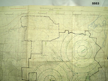
Map - MAP of PUCKAPUNYAL, RAAF et al, 1958
Refer to Cat 5547, Matheson.This is a large map, printed in colour on one side only. Scale 1:25,999. The grid squares are 1000 x 1000 metres. it shows the camp, ranges and bush areas used by the military.This map is covered in a large number of added colour shadings, nav lines, airstrips and circles.puckapunyal army base, military training, map -
 Melbourne Tram Museum
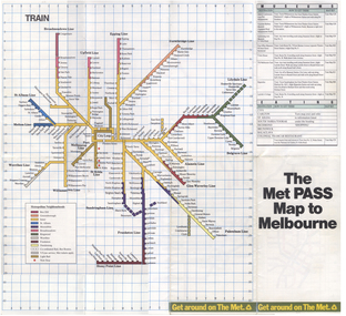
Map, The Met, "The Met PASS Map to Melbourne", c1988/90
... Maps ...Folded Map of Melbourne Rail and Tram lines, titled "The Met PASS Map to Melbourne" Tram Map - probably soon after conversion of the St Kilda and Port Melbourne lines to Light Rail, though these are not shown. Opened November 1987. Rail Map - shows Route 96 north section as Light Rail, co-ordinated bus routes, and the Altona line as going to Werribee. This route was opened in 1985. Date of Map c1988/1990. Has details of Museums, Art Galleries, Shopping, Gardens and Sports Arenas. See also Reg Item 379 for a similar item.trams, tramways, the met, melbourne, maps, tourist tickets -
 Canterbury History Group
Ephemera - A Golding Walk in Canterbury, Robin Da Costa-Adams, 2006
Walk organised by Robin da Costa-Adams describing 6 sites and a map of area covered by walk. Includes a colour photo of William Tibbitts painting "Canterbury in 1882". A4 sheet folded in landscape with colour photo and mapjohn august reserve, alfred golding, balwyn road, rochester road, balwyn methodist church, chaucers reception centre, "the pines" -
 Bacchus Marsh & District Historical Society
Map, Bacchus Marsh Suburban Allotments Parwan Road Lodge & Dunn's Paddocks 1888
This map was created as a plan for an auction of land close to the Bacchus Marsh Railway Station. The auction took place on 23 October 1888. 102 allotments of land from an area known as Lodge and Dunn's paddocks was offered for sale. A single page paper map showing allotments of land for sale along the Parwan Road in Maddingley. The map is pasted into a bound volume containing 76 maps or plans in total. High resolution digital image stored on BMDHS computer network. land sales bacchus marsh, land sales maddingley, bacchus marsh victoria maps, maddingley victoria maps -
 Greensborough Historical Society
Map, Green's subdivision of Greensborough, 1860c
This map shows the original subdivision of Greensborough by Edward Bernard Green. Some street names are different to today. This map shows the plan on which the town of Greensborough was based.Copy of early map showing subdivision of Greensborough. Black ink on white paper.edward bernard green, greensborough -
 Melbourne Tram Museum
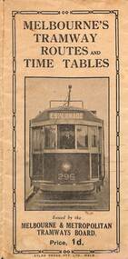
Map, Melbourne & Metropolitan Tramways Board (MMTB), Melbourne's tramway routes and timetables - MMTB, 1925
Map of the MMTB Tramway routes 1925 with a list of first and last cars, along with photographs of Wattle Park, Luna Park, and Studley Park. Provides information for the Prahran and Malvern lines, Hawthorn, Footscray, Essendon, Coburg, Kew, St Kilda, cable tram routes, and buses. Also provides information for passengers. The cover photo is of the front of W 296, with the destination of Esplanade. The map is dated by the opening of the line to West Brunswick as far as Albion St, the City Road to St Kilda line via Sturt St lines, and the electric line in Flemington Road which were all opened during mid to late 1925. See Reference. Shows a number of buildings and locations by a numbered reference list, including the Federal Parliament house. The map has advertisements around the outside of the map for Kiwi Shoe or boot polish.Yields information about the Melbourne tramway system in 1925 and demonstrates the methodology the MMTB used to provide information to travellers. Shows both cable and electric tram lines and the development of the Melbourne system.Map book - 15 fold paper titled "Melbourne's tramway routes and timetables"trams, tramways, mmtb, tramway maps, wattle park, studley park, timetables, cable trams, w class tram, tram 296, kiwi shoe polish -
 Lara RSL Sub Branch
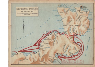
Map, World War 2 Borneo Area, 1945
Military maps of Australian Campaigns in the Borneo area World War 2paper coloured maps from unknown bookMap 1 Centre section opened - North Borneo Campaign June - July 1945. Closed Side 1 - Tarakan Campaign 1 May - 21 June 1945. Side 2 Balikpapan Campaign July 1945 Map 2 Centre section opened - Aitape-Wewak Campaign Nov 1944 - Aug 1945. Closed Side 1 Bougainville Campaign Nov 1944 - June 1945 New Britain Campaign Oct 1944 - July 1945borneo new britain bougainville wewak maps ww2 -
 Marysville & District Historical Society
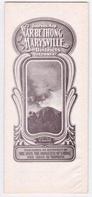
Map (Item) - Tourist Map, Department of Lands & Survey, Tourist's Map of Narbethong and Marysville Districts Victoria, 1913
A tourist map for the Narbethong and Marysville Districts that was originally produced by the Department of Lands & Survey in 1925.A tourist map for the Narbethong and Marysville Districts that was originally produced by the Department of Lands & Survey in 1925.Reprint of the 1925 Tourist brochure by permission R.E. Holmes Surveyor General By Authority: ALBERT J. MULLETT, Government Printer, Melbourne. Photo Lithographed at the Department of Lands and Survey Melbourne by W.J. Butson/ 26.8.13narbethong, marysville, victoria, department of lands & survey, the acheron valley, warburton, map, tourist map -
 Greensborough Historical Society
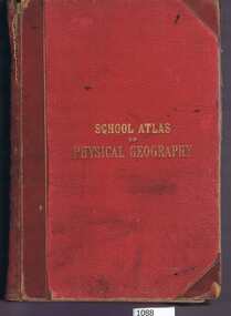
Book, W. & A.K. Johnston, School atlas of physical geography: the elementary facts of geology; hydrography; meteorology and natural history by Alex Keith Johnston, 1871_
This atlas of physical geography has 20 plates illustrating maps and various rock formations.This volume illustrates a 19th century view of physical geography.51 pages, 20 plates, maps. Red hard cover with title in gold lettering.Inscribed on fly leaf with original owner's name (1890)physical geography, school books, atlases -
 Warrnambool and District Historical Society Inc.
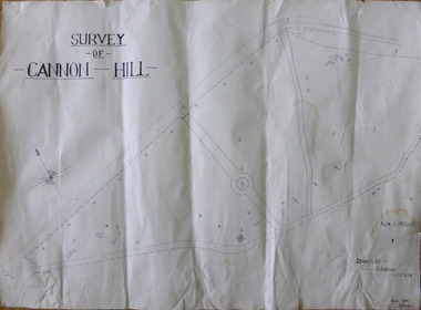
Work on paper - Project, Cannon Hill 1939, 1939
A map thought to be a school project depicting the layout of Cannon Hill, a popular lookout in Warrnambool.A locally drawn map indicative of school work from the 1930’s.A map thought to be a school project depicting the layout of Cannon Hill, a popular lookout in Warrnambool.Drawn by R Graham. Checked 13/02/1939 T E Wingrovecannon hill, school project 1939 -
 Marysville & District Historical Society
Map (Item) - Tourist Map, Department of Lands & Survey, Tourist's Map of Narbethong and Marysville Districts Victoria, 1913
A tourist map for the Narbethong and Marysville Districts that was originally produced by the Department of Lands & Survey in 1925.A tourist map for the Narbethong and Marysville Districts that was originally produced by the Department of Lands & Survey in 1925.Reprint of the 1925 Tourist brochure by permission R.E. Holmes Surveyor General By Authority: ALBERT J. MULLETT, Government Printer, Melbourne. Photo Lithographed at the Department of Lands and Survey Melbourne by W.J. Butson/ 26.8.13narbethong, marysville, victoria, department of lands & survey, the acheron valley, warburton, map, tourist map -
 Marysville & District Historical Society
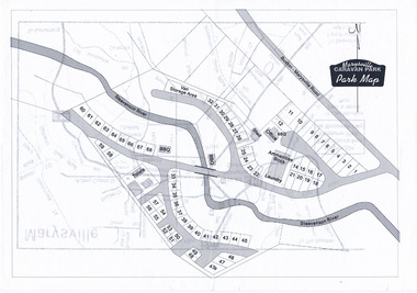
Map (Item) - Marysville Caravan Park map, Marysville CARAVAN PARK-Park Map, Unknown
A map of the Marysville Caravan Park showing the location of the various sites and facilities available to guests.A map of the Marysville Caravan Park showing the location of the various sites and facilities available to guests.marysville, victoria, australia, marysville caravan park, map -
Tatura Irrigation & Wartime Camps Museum
Map, Department of Land and Survey, County of Rodney
Early county maps.One original map of County of Rodney and 3 photo copies. Original and one copy in colour. 2 copies in black and white. county of rodney -
 Queenscliffe Maritime Museum
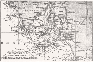
Map - B & W coastal map Spencer's Gulf & into Port Adelaide, South Australia, Coastal map of Port Adelaide South Australia showing Spencer's Gulf, Before donation in 1987
Australian coastal mapsAustralian coastal mapsB&W coastal 'soundings' map Spencer's Gulf & into Port Adelaide, South Australia., from an unknown book, pre-1987.Reverse " NIL "old maps of australian coast -
 Nhill Aviation Heritage Centre
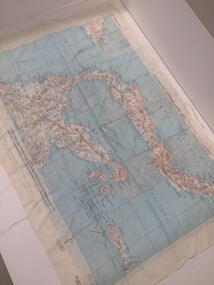
Map - Silk Map, No. 24 south celebes, c1942
Silk maps produced by the USA for the Pacific warWhite woven silk material with printed map and text North Celebes print on the reverse side South CelebesNo. 24 South Celebesusa, us army air force, silk, map, celebes, saam, -
 Marysville & District Historical Society
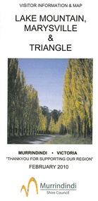
Map (Item) - Tourist map, Murrindindi Shire Council, VISITOR INFORMATION & MAP LAKE MOUNTAIN, MARYSVILLE & TRIANGLE, 02-2010
A visitor information map for Lake Mountain, Marysville and the local district produced by the Murrindindi Shire Council in February 2010. This information guide and map was produced after the 2009 Black Saturday bushfires destroyed most of the township of Marysville.A visitor information map for Lake Mountain, Marysville and the local district produced by the Murrindindi Shire Council in February 2010.Murrindindi Shire Council has made every effort to ensure the information provided at the time/ of printing is correct, but accepts no responsibility for an inaccuracies or omissions.lake mountain, marysville, victoria, australia, visitor information & map, murrindindi shire council, big 4 holiday park taggerty, black spur inn, black spur motel & caravan park, bush creek buddha, buxton hotel motel, cathedral valley farm, chestnut glade, crossways historic country inn, delderfield luxury b&b, kingbilli country estate, marapana agistment park & farm stay b&b, maryton park b&b, pinjarra gardens, sarsens rest, silverstream b&b, tower motel, willowbank at taggerty, wombat cottage, woodlands rainforest retreat, buxton general store and post office, buxton zoo nursery, cathedral view natural therapies, country touch, cross country ski hire, foodworks, highwood health retreat, lake mountain ski hire, lit & beyond, lj hooker, maroondah outdoor equipment/bait & tackle, marysville medical centre, marysville patisserie, marysville ski centre, marysville triangle real estate, marysville visitor information centre, mystic mountains ski hire/outdoors, pat's hairdressing, penni lanes country wares, plant's by shelian -
 Bendigo Military Museum
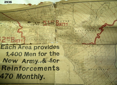
Map - MAP, RECRUITING AREAS, Sands & McDougall Pty Ltd, Possible WW1 era
... Maps ...Each Battalion area provided 1400 men for the New Army & for 470 Reinforcements monthly.Map, paper on canvas backing, depicts recruiting areas for the raising & maintenance of Territorial Battalions in Melbourne (Vic) & suburbs. Printing is black & white with battalion boundaries & names in red.maps, battalions, recruiting -
 Ballan Shire Historical Society
Map - Map. Shire of Ballan, Shire of Ballan
This is a fairly comprehensive map of the former Shire of Ballan which is now amalgamated into the Shire of Moorabool.A black and white map of the Shire of Ballan showing major roads, rivers, towns, settlements, State parks and forests and land subdivisions. It appears to be a copy of the original as no dates or maker or printer appear on the map. There is a scale of 2 miles to 1 inch.gordon, ballan, bungal, kerrit bareet, borhoneyghurk, bungeeltap, ballark, yaloak, gorong, beremboke, wallace, ingliston, hunterston, millbrook, bradshaw, myrniong, blackwood, moorarbool, greendale, bayup, trentham, bullarto, korweinguboora, glenlyon, bolwarra -
Stawell Historical Society Inc
Map, Borough of Stawell Parish of Stawell and Illawarra 10/06/1903, 10/06/1903
Department of Lands and Survey Map of Stawell with marked roads, allotments, physical landmarks. Found in Storage at ANZ Bank when the old archive was being cleaned out. Also shows Surveyed but unused roads. Showed where customers lived in StawellPholtolithograph Map - Paper on canvas backingBorough of Stawell. Parish of Stawell and Illawarra. County of Borong. Scale 8 Chains to 1 Inch. Scale 16 Chains to 1 Inch. Red Ink Writing, Purple and Blue.town -
Whitehorse Historical Society Inc.
Book, Sevenoaks Park, 1980 repr. 2004
A history of Jeffery Street Blackburn and surrounding area once known as Sevenoaks Park.A history of Jeffery Street Blackburn and surrounding area once known as Sevenoaks Park. Contains old maps and land titlesA history of Jeffery Street Blackburn and surrounding area once known as Sevenoaks Park. sevenoaks park, jeffery, mary ann, jeffery street blackburn, blackburn road blackburn, lake road blackburn, da costa, robin, burns, frank, satchwell, keith -
 Kiewa Valley Historical Society
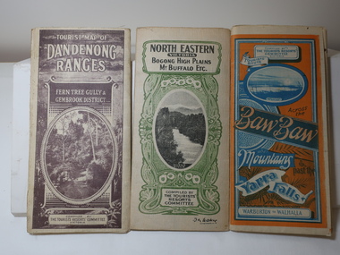
Maps - Tourist
These maps were all dated 1933 which was before the construction of the Kiewa Hydro Electric Scheme and when Tawonga was spelt Towonga. North East Victoria in 1933 was before the construction of the Kiewa Hydro Electric Scheme so the townships of Mt Beauty and Bogong are not shown. The description of the Snow Lines was important as skiers, bushwalkers and campers relied on them. The details on the map include "ADB. Numbered from A.1-377 round plates. CD Numbered from C 1-235 square plates. Poles about 3 chains apart 27 to the mile." 3 Tourist location maps (folded) and printed on parchment. 1. Tourist map of the Dandenong Ranges. Brown cover. dated 6-4-33. Govt. printer showing roads, tracks in red and heights of the land. 2. Tourist Map of Warburton, Mt Baw Baw, and Walhalla. Blue and Orange cover. dated 23-5-33 Govt. printer. 3 different maps of each area showin roads, tracks and timber tramways.Also in red and blue. 3. Tourist Map of North Eastern Victoria including Bogong High Plains Mt Buffalo Etc. Green cover. dated June 1933 Govt. printer. Main map and insert titled Bogong High Plains. Showing roads , tracks and tram ways. On insert showing snow poles. Also Red and Blue and mountains.By Authority of H.J. Green - 6 pence. Dept of Lands and Survey, Melbourne1933 maps, tourism maps, bogong high plains map 1933, snow poles -
 Bacchus Marsh & District Historical Society
Map, Limestone Reserve Parish of Merrimu 1888
Limestone deposits in the Coimadai area 10 kilometers north of Ballarat were first worked in the 1850s. The area was quarried for limestone for many years by various people and companies. The surveyor's name who produced this plan is inscribed on the map and below this is the name P. L. Alkemade, who presumably paid for the map to be produced. In 1886 Petrus Alkemade in partnership with Matthew Egan established the Alkemade Hydraulic Lime and Cement Company. The Alkemade family were involved in the limestone industry over several generations at Coimadai.Single page map showing part of the Limestone reserve near Coimadai in the Parish of Merrimu. Scale 4 chains to 1 inch. Part of a set of maps which are pasted into a bound volume containing 76 maps or plans in total. High resolution digital image stored on BMDHS computer network. Copy of plan surveyed by Mr. G? [illegible] an authorised surveyor on 17th July 1888. P. L. Alkemadebacchus marsh victoria maps, lime kilns coimadai, limestone, coimadai victoria maps, alkemade family coimadai -
 Greensborough Historical Society
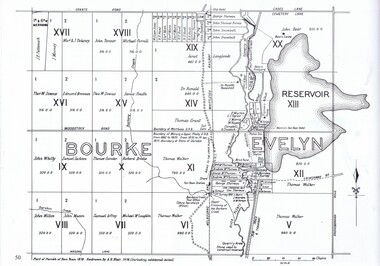
Map, Dianne Edwards, Part of Parish of Yan Yean 1878, 1978
Map includes Crown Portions V - XVII, showing Yan Yean Reservoir, Melbourne-Whittlesea Railway route, names of landowners, roads and various other features west of Greensborough Road. Redrawn by A. R. Blair in 1978.1 p. black and white photocopy of mapyan yean reservoir, yan yean -
 Bacchus Marsh & District Historical Society
Map, Gaynor Street Land Sales, Maddingley, circa 1880s-1890s
This map was produced for a major sale of land in the Maddingley area of Bacchus Marsh. The precise date of the sale has not been determined. Features present on the map such as the Bacchus Marsh Railway Station indicate the land sale must have taken place some time after 1887 when the Railway Station opened. A single page paper map showing land allotments for sale in the Maddingley area of Bacchus Marsh. Locations shown include Gaynor Street, Maddingley Road South, Parwan Road, Mitchem Street, Typpynge Street, Finn Street and East Maddingley Road. . The map is pasted into a bound volume containing 76 maps or plans in total. High resolution digital image stored on BMDHS computer network. bacchus marsh victoria maps, maddingley victoria maps, land use, maddingley victoria history, land sales bacchus marsh, land sales maddingley -
![Map, Plan of Subdivision [Allotments along Lerderderg, George and McFarland Streets]](/media/collectors/5e461d8021ea67224c82f2a1/items/675d7243165f146b8adfc656/item-media/675d72d7165f146b8adfc859/item-fit-380x285.jpg) Bacchus Marsh & District Historical Society
Bacchus Marsh & District Historical SocietyMap, Plan of Subdivision [Allotments along Lerderderg, George and McFarland Streets]
This map shows allotments of land on the northern side of Lerderderg Street from Gisborne Road through to the approximate site of the present day Bacchus Marsh Primary School. There are also allotments shown on the southern side of McFarland Street between George Street and Gisborne Road. Larger allotments of land are shown extending northwards towards Masons Lane. Inscribed at the top of the map are the words, 'Plan of Subdivision of Cr Pors (Crown Portions) 12 & 13 & Allotments 1,2,3,4, Block 3, Parish of Korkuperrimul, County of Bourke'. The date of the map has not been established but the absence of the Bacchus Marsh Primary School on the map suggests it may have been produced prior to 1865 when the primary school was built in Lerderderg Street.Single page map showing house block size land allotments in the Lerderderg, George Street and McFarland Street area of Bacchus Marsh with larger allotments north of this area towards Masons Lane also shown. Scale 150 feet to 1 inch. Part of a set of maps which are pasted into a bound volume containing 76 maps or plans in total. High resolution digital image stored on BMDHS computer network. bacchus marsh victoria maps, lerderderg street land allotments, mcfarland street land allotments -
 Melbourne Tram Museum
Document, Ministry of Transport, Melbourne Public Transport Map - No. 12, 1982
Map No. 12 - Includes description of tram and bus routes, private bus routes. On the front cover is composite image of Melbourne public transport vehicles. Has contact details for bookings and lost property etc and how to use the map. Priced at 40c, issue No. 12 of c1982. Has details of the then new Travelcard ticket system. Yields information about Melbourne public transport services in 1982.Fold out map (36 sections 9 across x 4 deep), "Public Transport Map", coloured of Melbourne's Tram and Bus routes, route numbers, rail lines, detailed for the central part of Melbourne and the outer Metropolitan services.tramways, melbourne, tram services, bus services, railways, travelcard -
 Eltham District Historical Society Inc
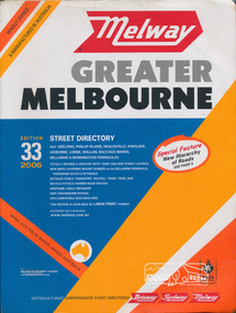
Book, Melway Publishing, Melway Greater Melbourne street directory : including Geelong, Phillip Island, Healesville, Kinglake, Gisborne, Lorne, Wallan, Bacchus Marsh Bellarine & Mornington Peninsulas; Edition 33, 2006, 2005
Edition 33. 2006 Coloured detailed maps accessed by a street or location index. Cover: Totally revised and updated with over 1380 new street listings new maps covering Mount Duneed on the Bellarine Peninsula, Pakenham South and Rythdale. Detailed public transport routes - train, tram, bus, bicycle paths & shared road routes. Eastlink fully detailed new Craigieburn bypass GPS compatible WGS/MGA Grid Special feature: New Hierachy of Roads Street directory with plastic cover, coloured maps, 902 pagesstreets,roads,melbourne,map,melway -
Whitehorse Historical Society Inc.
Pamphlet, Information Bulletin, 1/12/1993
Freeway Extension between Doncaster Road and Springvale Road to go ahead.Freeway Extension between Doncaster Road and Springvale Road to go ahead. Map showing location and history of project given.Freeway Extension between Doncaster Road and Springvale Road to go ahead. freeways, doncaster road, doncaster, springvale road, nunawading, vicroads, city of nunawading, city of camberwell, city of box hill, city of ringwood -
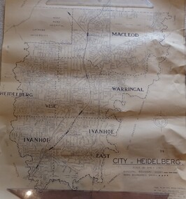 Greensborough Historical Society
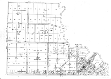
Map, City of Heidelberg. Engineers Dept, City of Heidelberg, 1960s
Map of the City of Heidelberg from the Yarra River in the South to North of Watsonia Military Camp. Shire of Diamond Valley is shown to the north.Map showing municipal and ward boundaries, black text on light brown paper."Scale: 20 CHS = to 1 IN"city of heidelberg -
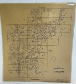 Greensborough Historical Society
Poster - Map, City of Heidelberg, 1984
Numbered grid map of the City of Heidelberg showing municipal boundaries in 1984 . Scale 1 inch to 160 feet. Side 2: MMBW Plans Yarra 2000, note Ward boundaries not updated on this plan.An example of hard copy plans from the 1960s. Mainly from the Shire of Diamond Valley era (1964-1994).Map printed on brown paper and laminated. Double sided.city of heidelberg, mmbw