Showing 10184 items
matching dandenong
-
 Ringwood and District Historical Society
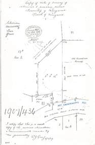
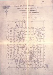
Document - Copy of Lands Department Field Notes - Survey of Extension to Recreation Reserve, Township of Ringwood, Victoria, Field Notes 1907/436 - Part of O.P. R72D Surveyed 6.8.1907
Foolscap size photocopy of survey map with handwritten notations. References include New Lilydale Road 3 chains wide (Mount Dandenong Road), Silurian, undulating, poor grass, Corner cut off to allow for road in future subdivision, Old recreation reserve, (circled area) oval now in use, A. Gisler, I certify that this is a correct copy of the recorded observations & measurements made by me personally (signed) R.J. Gray 6/8/07. -
 Melbourne Tram Museum
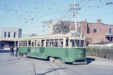
Photograph - Five color slides - tram PCC 980, 9-8-1970
Set of four colour slides taken during the Monash Railway club tour on 9-8-1970 using PCC 980 from Malvern Tram Depot. The route number and destinations are for show only. Photographs by Warren Doubleday.Yields information on Monash Railway club tour, the trams used and the locations.Set of five Anscochrome colour slides, of Melbourne tram PCC 980 on a Monash Railway Club tour - 9-8-1970 .1 - PCC 980 on the depot access tracks for Malvern Tram Depot in Coldblo Road .2 - With the Malvern Tram Depot in the view .3 - In Dandenong Road at Hawthorn Road .4 - Crossing Hawthorn Road - has a tram shelter in the view. .5 - About to use the then new Nolan St (now Southbank Blvd) crossover.Has photographers slide numbers on each slide.monash railway club, tram 980, malvern depot, hawthorn road, dandenong road, nolan st, tramways, trams, pcc class -
 Melbourne Tram Museum
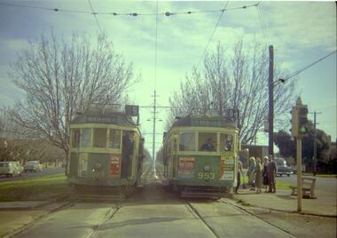
Negative, Travis Jeffrey, 10/06/1962 12:00:00 AM
Colour negative of trams 514 and 953 in Dandenong Road. Tram 514 has destination Malvern - Burke Rd and Route No 5. Photo shows tram on the left track (city-bound), although facing towards its destination (Malvern). Driver standing in door of cab and conductor standing in doorway to tram. Tram 953 has destination East Brighton via Caulfield and Route No 64. Sign on front states: "Connect with Malvern-Burke Rd tram".Paper folder that contained the negative had "NR75B" and date written as 10 Jun 62 in red ink.trams, tramways, w2 class, route 5, route 64, dandenong rd, wattle tree rd, malvern burke rd, tram 514, tram 953 -
 Whitehorse Historical Society Inc.
Photograph, Australia Post delivering Post Box, 1/09/2000 12:00:00 AM
This item was originally acquired by Harold Bakes, together with a Fire Hydrant Stand And a petrol pump , from the P.M.G. depot in Hawthorn in the 1970s . It was stored in the City of Nunawading Council yard in Station Street, Nunawading, and later loaned to the Australia Post Mail Exchange in Rooks Road, Nunawading. On the closure of the Mail Exchange, it was transferred to the Australia Post Museum in Dandenong. After proving ownership it was returned to back to the Society's Museum.Coloured photo of an Australia Post delivering restored Post Box to the Society's Implement Shedaustralia post, bakes, harold arthur -
 Disability Sport & Recreation Victoria
DVD, 2012 National Wheelchair Basketball League Finals, 20/06/2012
The DVD features footage from two matches from the 2012 season of the National Wheelchair Basketball League. The DVD features extended highlights from the game for 3rd/4th place, between the Sydney University Wheelkings and Dandenong Rangers. Following this game is the full recording of the championship game played between Perth Wheelcats and Wollongong Rollerhawks. These games were played in Shellharbour on the New South Wales south coast.DVD inside case2012 National Wheelchair Basketball League Finalsdjuro sen, national wheelchair basketball league, wheelchair basketball, sydney university wheelkings, perth wheelcats, wollongong rollerhawks, dandenong rangers, dylan alcott -
 Ringwood and District Historical Society
Map - Public Land Sale by Thomas Ham, 2000 Acres for Sale - Crown Sections 20, 23, 24 - Ringwood, Victoria - 1855
Two 1850s surveyor's maps on cardboard backing showing area from Melbourne extending East beyond Bulleen and Nunawading. Detailed description of lots for sale and navigational directions to the property from Richmond by Thomas Ham, Victorian public servant, map maker, publisher, lithographer and original Ringwood land owner. Inset map enlarging area between Yarra River and Dandenong Creek, with southern boundary of allotments later forming part of Oban Road, North Ringwood.TRANSCRIPT: "This really valuable Property is now offered to the public for sale, in lots to suit purchasers at the Iow rate of £1 per Acre for 80 acres and upwards, and £1.10s per Acre for any smaller portion. Terms of payment Half Cash, Balance in 6 and 12 months, bearing 8 per cent interest. The Estate is well wooded with Gum, Cherry Tree and Stringy Bark, with Wattle in the valleys of the several creeks. Every lot is Staked and Trenched at the corners marked on the Plan thus - The Surveyor has carefully sub-divided the Property, in order to give every Farm a Creek for Water, Valley for Cultivation, and Hills for House and Grass Paddock. The ROADS have been very carefully laid out so as to give a firm, well drained, and nearly level road to each Homestead. Intending purchasers can readily find the property by the following directions, viz: Start from Richmond Bridge, at Hawthorne, then take the left-hand road to KEW. When at the "Woodman Inn", take the Cotham Road to the right, bearing due east, keep this Road, passing Trainor's "White Horse" Inn, and before you leave the fences, you will see calico bills (see margin) nailed to the Trees on the bush track leading to the Upper Yarra country, follow the Bills till you come to the SOUTH boundary line of the Property, which bears East and West (see Plan) where you will see Bills nailed up "THIS PROPERTY FOR SALE, etc." The Bills from Town lead direct to where Mr. Jull is erecting his Store, and arrangements have been made with him to show the lots to intending purchasers free of charge. At the respective corners of the lots the Bills are nailed up double, with numbers to denote the lot, and that the corner stake is adjacent. Any parties wishing to proceed to the property by way of BULLEEN will find Bills nailed on the Trees, commencing at the NEW INN, at "Wilson's Slip Rail." Keep this Track till you come to the Log Bridge, over the Deep Creek at Bloxhome's Paddock; go through the land now being cleared; keep the track over the hill till you come to an Iron House, you will then be on the property, which Iies to the North and East as per Plan. Follow the Bills till you come to Mr. Jull's Store, etc. etc. Further particulars can be had from the Agent for the Property. THOMAS HAM. " -
 Ringwood and District Historical Society
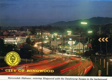
Postcards, Colorscans (Publishing) Pty Ltd, Various postcards of Ringwood in the 1970s, c. 1968
Postcards - pack of 6: 'Ringwood Victoria - tear off postcard folder - 6 views' (two identical folders); 1. Maroondah Highway, entering Ringwood with the Dandenong Ranges in the background (3303_001.jpg); 2. Aerial View of the City of Ringwood (3303_002.jpg); 3. Eastland Regional Shopping Centre at dusk (3303_003.jpg); 4. The Ringwood Memorial Clock Tower (3303_004.jpg); 5. The Civic Centre (3303_005.jpg); 6. The Ringwood Lake (3303_006.jpg) -
 Ringwood and District Historical Society
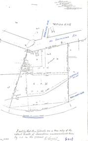
Document - Copy of Lands Department Field Notes - Parish of Ringwood, Victoria, Field Notes - OP34838 - surveyed in 1919 by D. Barker
5615b Foolscap size photocopy of survey map with handwritten notations. References include Braeside Avenue, Mount Dandenong Road, Rosedale Court, Railway Avenue, cyclone fence, Sec A, WB house, old tennis court netted, stable, old shed, tank stand, orchard, Township Boundary, netting fence, Railway fence, Ringwood to Lilydale Railway, I certify that these fieldnotes are a true copy of the actual results of observations & measurements taken by me on the ground (signed) D. Barker (1919). -
 Ringwood and District Historical Society
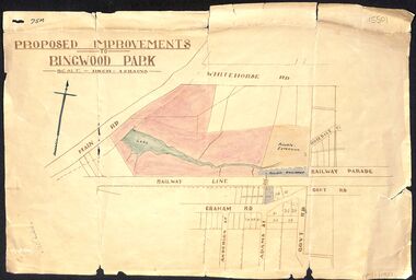
Map, Proposed Improvements to Ringwood Park (Ringwood Lake) dated 14 January 1927
Proposed Improvements to Ringwood Park (Ringwood Lake) dated 14 January 1927, signed Cr McCaskill. Main Road is Whitehorse Road (Maroondah Highway), and Mt Dandenong Road is incorrectly labelled Whitehorse Road. The map shows Rosedale Crescent and Railway Parade, both of which exist in 2024. On the bottom of the map, south of the railway line, showing proposed streets - Graham Road, Anderson Street and Adams Street - in preparation for the sale of the Theo Anderson property. That area is now Bedford Park. -
Whitehorse Historical Society Inc.
Document, Fruitgrowing in early Vermont
Handwritten information about fruit growing in Vermont from about 1880 to 1945. the area bounded by Boronia Road, the Dandenong Creek and Morack Road was a grant by Queen Victoria to an old soldier named Moore.Handwritten information about fruit growing in Vermont from about 1880 to 1945. the area bounded by Boronia Road, the Dandenong Creek and Morack Road was a grant by Queen Victoria to an old soldier named Moore. This area was subdivided about 1880. A few fruit trees planted. Later Williams Pears and Jonathan Apples were found to be best to grow. The peak of growing fruit was 1930 - 39 and steadily declined after this due to labour shortages and lack of markets during 1939 - 1945.Handwritten information about fruit growing in Vermont from about 1880 to 1945. the area bounded by Boronia Road, the Dandenong Creek and Morack Road was a grant by Queen Victoria to an old soldier named Moore. orchards, boronia road, vermont, dandenong creek, moore, isaac, morack road, vermont south -
 Southern Sherbrooke Historical Society Inc.
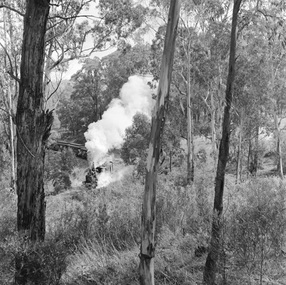
Photograph - Puffing Billy train
Two black and white photos dated 1962 from the National Archives of Australia, showing the Puffing Billy train in the Dandenongs. - Ground is steep and heavily treed and may be the stretch of line between Menzies Creek and Clematis Station. - Large trees line the track. There is a driveway below the line with large puddles. A car can be seen crossing the line behind the train. A lightly treed hill is visible in the background. This may be the crossing at the Clematis end of Menzies Rd with Tivoli Farm in the distance. -
 Ringwood and District Historical Society
Document - Folder, Land Sale, Parkhaven Estate, Heathmont, Victoria - 1968
Manilla folder containing 2-page foolscap size typewritten summary of Parkhaven Estate Heathmont multiple release allotment prices and two maps headed Plan of Subdivision - Part of Crown Portion 13, Parish of Ringwood. Subdivision includes Cuthbert Street, Waterloo Street, Sunset Drive, Markhill Place, Parkhaven Drive, Bayley Close and Blenheim Street. Agents - Consolidated Home Industries Limited, Lower Dandenong Road, Braeside, Vic., Phone 91-9791. Rep - Bruce Grant.Accompanying handwritten sales note researched in 2024 by Richard Carter - Carter Real Estate - "Generally $2500 to $4000 per lot". -
 Melbourne Tram Museum
Administrative record - Depot Table Sheet or Block, Melbourne & Metropolitan Tramways Board (MMTB), "Sunday 14-1-1968 - Glenhuntly - North Fitzroy - Kew - Malvern - Doncaster", Jan. 1968
Depot table sheet or block - roneo or spirit duplicated, printed on light card - for - "Sunday 14-1-1968 - Glenhuntly - North Fitzroy - Kew - Malvern - Doncaster" shows the various runs and crew tables for the day, has an index and notes. The block was prepared for the track work to realign Dandenong Road and the Chapel St intersection as part of the St Kilda Junction project. See page 96 of Timeline History of Melbourne's Government Cable and Electric Trams - Barry George et al.trams, tramways, table cards, glenhuntly tram depot, kew depot, north fitzroy depot, doncaster depot, malvern depot, drivers, conductors, st kilda junction -
 Melbourne Tram Museum
Slide - Set of 3, Colin Rough, 29/04/2003 12:00:00 AM
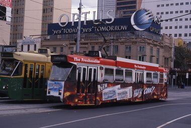
Set of 3, 35mm Tecnodia white plastic mount slides of trams in Swanston St at Flinders St Station 29/4/2003. Trams in M>Tram livery. .1 - Z3 209 in all over advertising for Mentos mouth fresheners. Has Young & Jacksons Hotel behind with a large sign for Optus. Also the Dangerfield building. .2 - D1 3509, Malvern Rd via Dandenong Rd and as above re background. .3 - Z3 117 inbound, with destination of Melbourne University.On front written on a label "M>Tram, Flinders St station, Melbourne 29/4/03" and the tram number.trams, tramways, swanston st, flinders st, flinders st station, z3 class, tram 209, tram 3509, tram 117, m>tram, d1 class -
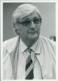
 Uniting Church Archives - Synod of Victoria
Photograph, John E. Blacker, 13/06/1984
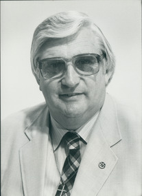
John E. Blacker was a Methodist and then Uniting Church miinister - placements at Dandenong (Lilydale), Kilmore & Broadford, Kerang-Barham, Sunshine, and Moonee Ponds. In the early 1980s he led a charismatic renewal program at Sunshine and Moonee Ponds, and was involved with a controversy over re-baptisms. At a later point, he resigned from the Uniting Church ministry to lead the "Advance & Restoration Ministries" program that he and his son, Paul, managed.Head and shoulders studio portrait of John Blacker when still a Uniting Church minister, but working as "Advance & Restoration Ministries" which was then located in the 3rd floor of the Synod offices at 130 Little Collins Street Melbourne.Photo has John Blacker's name, and an "Advance & Restoration Ministries" label stuck on it.blacker, john e., advance & restoration ministries -
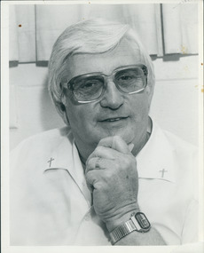
 Uniting Church Archives - Synod of Victoria
Photograph, John E. Blacker, 13/06/1984
John E. Blacker was a Methodist and then Uniting Church miinister - placements at Dandenong (Lilydale), Kilmore & Broadford, Kerang-Barham, Sunshine, and Moonee Ponds. In the early 1980s he led a charismatic renewal program at Sunshine and Moonee Ponds, and was involved with a controversy over re-baptisms. At a later point, he resigned from the Uniting Church ministry to lead the "Advance & Restoration Ministries" program that he and his son, Paul, managed.Head and shoulders portrait of John Blacker when still a Uniting Church minister, but working as "Advance & Restoration Ministries" which was then located in the 3rd floor of the Synod offices at 130 Little Collins Street Melbourne.John Blackerblacker, john e., advance & restoration ministries -
 Uniting Church Archives - Synod of Victoria
Photograph, John E. Blacker, 10/07/1985
John E. Blacker was a Methodist and then Uniting Church miinister - placements at Dandenong (Lilydale), Kilmore & Broadford, Kerang-Barham, Sunshine, and Moonee Ponds. In the early 1980s he led a charismatic renewal program at Sunshine and Moonee Ponds, and was involved with a controversy over re-baptisms. At a later point, he resigned from the Uniting Church ministry to lead the "Advance & Restoration Ministries" program that he and his son, Paul, managed.Head and shoulders studio portrait of John Blacker when still a Uniting Church minister, but working as "Advance & Restoration Ministries" which was then located in the 3rd floor of the Synod offices at 130 Little Collins Street Melbourne.John Blackerblacker, john e., advance & restoration ministries -
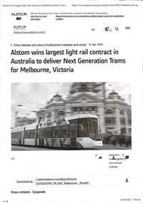 Melbourne Tram Museum
Document - Press Releases - G class tram for Melbourne
Set of two documents downloaded from the respective websites about the announcement of an order for the next 100 trams for Melbourne to be known as the G class tram. Gives details of the builder (Alstom), the contract price, the trams and that they would largely be manufactured in Melbourne at Dandenong. The (Government's) document explains their reason why the tram is to be known as the G class rather than using the next letter (F), in the alphabet following E for the E class tram. Yields information about the proposed new type and class of tram for Melbourne.Set of two press releases regarding the new "Next Generation" trams for Melbourne, to be known as the G class .1 - 8 page - from Alstom .2 - 12 page from the Victorian Department of Transportnew trams, design of new trams, g class, trams, tramways, melbourne, alstom, department of transport, press releases -
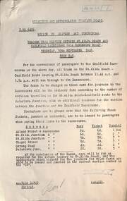 Melbourne Tram Museum
Document - Notice, Melbourne & Metropolitan Tramways Board (MMTB), Tramway Board (MMTB), Fares Caufield Racecourse, Sept. 1948
Notice No. D6406 and D6407, issued to advise Drivers and Conductors of the through trams from St Kilda Beach to Caulfield Racecourse, via Dandenong Road on Showday 30-9-1948. Gives the fares to be charged for each section for both the forward and return journeys. Second page gives the fares for special trams from the Racecourse to Cotham Road Kew - minimum fare for 4d. Issued to crews at Malvern and Kew Depots.Yields information the tram fare arrangements for the Caulfield Races Show Day in 1948.Document two foolscap duplicated sheets, pinned in top left hand corner.tramways, caulfield races, special trams, fares, tickets, notices to staff -
 Mt Dandenong & District Historical Society Inc.
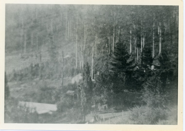
Photograph, View Over Roof of "Kalorama"
Taken in 1908, this photograph, though rather blurry, gives an indication of the location of the early settler properties in the valley in relation to one another. European trees have been planted at 'Kalorama' , the first home of Ellis Jeeves. John Lundy-Clarke grew up in the Kalorama/Mt Dandenong area and later in life (1972-74) began to write a comprehensive history of the area working from an original settlement map in an effort to cover all areas.Black and white photograph looking across hillside with large trees and rooftops visible. Handwritten description on reverse by John Lundy-Clarke.1908 View over roof of “Kalorama” towards the Falls. Paynter’s house on LOT 29 in low centre (now “Yosemite”). Pimms house on LOT 19 above Paynters and beyond scrub. Logan’s house faint above left of “Kalorama”. Dunbar’s LOT 20 beyond Pimm’s orchard. Gum trees on right were on Price’s LOT 19 now Tosari Rd area. It was one of these that figured in the episode of the runaway log in 1930. It leaped in one bound over Barbers Road at bottom of scrub in centre of picture then over Logan’s house.kalorama, ellis jeeves, jeeves -
 Mt Dandenong & District Historical Society Inc.
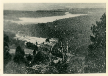
Photograph, Harmony Vale 1933
John Lundy-Clarke grew up in the Kalorama/Mt Dandenong area and later in life (1972-74) began to write a comprehensive history of the area working from an original settlement map in an effort to cover all areas. Harmony Vale was the name of the homestead built by early pioneer Jabez Richardson. The whole of the valley took on this name. The building lasted until 1933. The Silvan Dam was completed in 1932 and was full when this photograph was taken.Black and white photograph looking down over a forested area with a dam in the background. Copied from a Rose Series postcard c1933. Handwritten inscription on reverse by John Lundy-ClarkeRose Series photo of 1933 showing “Harmony Vale” still standing. Copied 1973 JLCharmony vale, silvan dam, jabez richardson -
 Mt Dandenong & District Historical Society Inc.
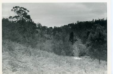
Photograph, View Up Valley Towards Kalorama Gap 1973
John Lundy-Clarke grew up in the Kalorama/Mt Dandenong area and later in life (1972-74) began to write a comprehensive history of the area working from an original settlement map in an effort to cover all areas. This photograph would have been taken to show the changes in the area over the years. Kalorama Gap is now called Five Ways. 'Kia-Ora ' was a guest house built by George Barber. It is no longer standing.Black and white photograph showing a bush scene with a white car visible on the right. Handwritten inscription on reverse by John Lundy-Clarke1973 View up Valley towards Kalorama Gap from what was Crooks LOT 24. White car is on Barbers Road and site of “Kia Ora” is to right of it.kalorama, kalorama gap, five ways, barbers road, george barber, kia-ora -
 Mt Dandenong & District Historical Society Inc.
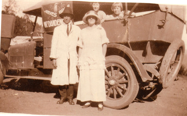
Photograph, Hubert Jeeves and Passengers with new Motorised Coach c1924, c1924
Hubert Jeeves in hat and dust coat standing with a woman in 1920s style clothing beside Jeeves Bros. motorised coach. Two girls are looking out of the coach at the camera.The coach has the insignia of a kookaburra and gum leaves with Jeeves Bros. painted in a boomerang shape with Mt Dandenong below. Hubert Jeeves, son of Ellis and Eliza Jeeves, started up his motorised coach business following his return from WW1.Sepia photograph showing a man an woman standing beside a motorised coach. Two children can be seen looking out of the vehicle.coach service, jeeves, hubert jeeves -
 Phillip Island and District Historical Society Inc.
Photographs, Early 20th Century to mid 20th Century
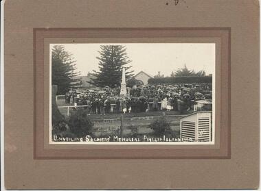
A collection of three photographs and one Identity Card donated by Alice Robinson.352-01: Black & White photograph on cardboard mount of the crowd at the opening of the Cowes War Memorial at the Jetty, The Esplanade, Cowes. 352-02: Sepia photograph of Horrie Matthews' home in Church Street (near Shamrock Avenue) Cowes with several horse drawn carts loaded with wood. Watched by a group of men. 352-03: Black & White photograph of children and teachers & adults at the Ventnor State School in May 1939. 352-04: Identity Card for Alice Isobel Giles-Clark, Cowes, Phillip Island. Possibly now Mrs Alice Robinson - the donor.351-01: Unveiling soldiers' Memorial Phillip Island 1920. 351-04: On front - Identity No. V10 F28 36869 Officer at Dandenong. Stamped May 43. On back - signature of holder "A. Clark Cowes" Witness to signature "Edith E Coels, Ventnor, Phillip Is."war memorial cowes phillip island, ventnor state school, horse drawn wagons, alice robinson, identity card -
 Ringwood and District Historical Society
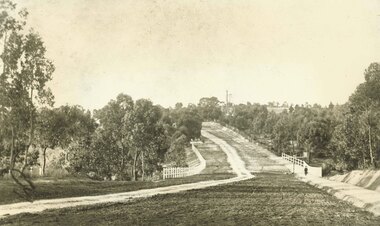
Photograph, Maroondah Highway East, Ringwood- 1900. Sandy Creek Bridge, Maroondah Hwy
3 photographs ( 2 large black and white, 1 small sepia)Written on all copies: "New Sandy Creek Bridge". Typed below large photograph: "Maroondah Highway Ringwood looking east. To right of bridge is now Ringwood Lake. Mount Dandenong Road turnoff to right at top of rise with antimony mine in background - 1900". -
 Mt Dandenong & District Historical Society Inc.
Photograph, Erith Lane
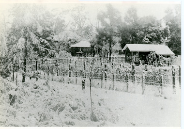
Erith Lane would have been named after Eliza Erith, the wife of Thomas Hand of Mountain Grange. The house made of slabs and bark pictured (centre) is where the family lived before Mountain Grange was built. Mabel Hand, Thomas and Eliza's youngest daughter stated that she was born in the bark hut in 1881 and they moved into the new home the same year. Cherry Farm, the roof visible behind the centre building, was the home of William Hand, son of Thomas and Eliza. He lived here with hs wife, Harriet Toghill, before moving to live at Mountain Grange after 1905.Black and white photograph showing a scene under heavy snow. Two cottages and a rooftop visible. Snow laden vines forming the front fence. Taller trees visible in the background. Reverse of photograph has handwritten description by John Lundy-Clarke.Erith Lane under snow. House in passion fruit Ivory’s holiday home 1921. Building in centre was Hand’s 28’ by 22’ house of slabs and bark. The first house on top of the whole Dandenong Range built 1871. Large roof behind it was “Cherry Farm”.eliza erith, eliza hand, mabel hand, thomas hand, william hand, erith lane, kalorama, snow, mountain grange, cherry farm, harriet toghill -
Glen Eira Historical Society
Article - Olympic Games 2000
This file contains one item relating to the torch relay of the 2000 Olympic Games: 1/A newspaper article from the Glen Eira News, Vol. 44, September 2000, describing the events of a leg of the Olympic torch relay that went down Hawthorn Road, between Dandenong Road and North Road. The article includes 6 colour photographs taken by Bernie Bickerton and an article written by primary school student Daniel Kontrobarsky describing the event. Author unknown.hawthorn road, north road, dandenong road, olympic games, olympic torch, children, councillors, athletes, aged people, bickerton bernie, gardenvale primary school, kontrobarsky daniel, police, caulfield, caulfield north, caulfield south, glen eira, irwin chris, brown damien, stacey jay, cordingley louise, bentleigh east, glen eira town hall, primary schools, camden community, rosstown community, torres ron, local officials and employees -
 City of Moorabbin Historical Society (Operating the Box Cottage Museum)
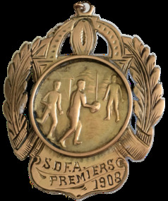
Badge - S.D.F.A. Premiers 1908 (Sandringham District Football Association), c 1908
Sandringham and Ellindale (now McKinnon Football Club) played off for the district premiership on the Friendly Societies Ground, Melbourne on 26 September 1908. Ellindale won the game but had to wait to see if they won a protest against Dandenong before they could claim that they had won the premiership. In the local paper, the Brighton Southern Cross on Saturday 10 October 190, it was reported that Ellindale were the premiers of the season. This medal was awarded to W. Kennedy, who was a forward for Ellindale.A Premiership Medal presented in 1908 to W.Kennedy an early settler in Moorabbin Shire The Medal is made from 9ct gold and engraved with a sheath on the edges and a picture of men playing football in the centre,Side one - S.D.F.A. Premiers - 1908 Side two - Ellindale F.C. W. Kennedy Forwardsandringham football club, ellindale football club, football final 1908, w. kennedy, mckinnon football club, sandrigham district football association, moorabbin shire, early settlers, market gardeners -
 Uniting Church Archives - Synod of Victoria
Photograph, April 21 1984
This photograph was published in Church and Nation, May 8 1985. It shows Jack Sherwill (centre) at work during the last camp he cooked for - Easter 1984. Others with him from left, Wayne Minge (Dandenong), Judy Cakebread (Benalla), Terry Ellis (Benalla) and Lionel Moore (Springhurst). Mr Sherwill became chief cook at the first Wandiligong Easter Camp in 1958. The Jack Sherwill Log Cabin was officially named on April 7 1985.Colour photograph of a group of 5 people eating sausages in bread at Wandiligong Easter Camp 1984camp wandiligong, easter camp, jack sherwill, wayne minge, judy cakebread, terry ellis, lionel moore -
Kew Historical Society Inc
Album - Construction of the electric tram line in Cotham Road, Kew, E.J. Dower, 1913
E.J. Dower was born and raised in Olinda. He later moved with his parents to Surrey Hills. He worked as an adult as a clerk in the city office of the Metropolitan Gas Company, and in his role as a 'collector', was able to photograph scenes including the construction of tram and train lines and associated buildings in Kew, Hawthorn, Camberwell and Surrey Hills. Later he established a real estate agency with his brother - the E.J. Dower Real Estate Agency, Dandenong Office.The album and its photographs are an historically significant record of the development of transport infrastructure which was used to connect Victorians in the first two decades of the twentieth century. This development resulted from increases in population and the consequent extension of Melbourne's suburbs. The photographs in the album, as well as Dower's single photos mounted on card, detail the labour of workers and the tools and machinery used to create and extend Melbourne's tram and train networks in the years preceding and during World War 1.Album of six annotated photos of construction of the St Kilda to Kew electric tram line, taken in Cotham Road, Kew, by the amateur photographer, Edgar James Dower, in 1913. The album contains images detailing the preparation for the laying of the tracks plus work on laying the line. The album, together with other phots by E.J. Dower has been made available by the owners for the Kew Historical Society to digitise and publish online and in print.Annotations by the photographer, often added over time, on the reverse of each photo in the album.theme -- connecting victorians by transport and communications, theme -- travelling by tram, photographers -- edgar james dower, cotham road -- kew (vic.)