Showing 3007 items
matching lane a.
-
 Eltham District Historical Society Inc
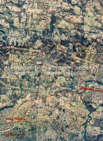
Photograph - Aerial Photograph, St Helena to Yarrambat, Vic, c.1995
Red annottions showing Nillumbik Shire Office in lower left extending to Diamond Creek centre right up to Yarrambat Marked: Submission 25/420 G. Frantal Hillmartin Road (Group) [Hillmartin Lane, Diamond Creek]aerial photo, diamond creek, eltham north, greensborough, hillmartin lane, nillumbik shire council offices -
 Ringwood and District Historical Society
Photograph, Canterbury Road, Ringwood taken under power lines looking east just east of Heatherdale Road. 1979
Written on back of photograph, "Jan. 79. Canterbury Road taken under power lines looking east just east of Heatherdale Road looking up the two-laned Road towards Cadbury McRobertsons before road widening". -
 Chiltern Athenaeum Trust
Book, Gospel St Mark
Handwritten inscription refers to 16th Reinforcements G.S.G (General Service Group). Transported back to Australia via Troop Ship SS Riverina. Printed by Cambridge. Printed at the University Press, for The British and Foreign Bible Society 146 Queen Victoria Street London.Was given to Richard Evans who was born in Chiltern Valley ( who served in WW1 )Blue soft cover fabric weave. Parchment coloured pages with small black print. 64 pages. No. 69029. Pt. R Evans 16th Reinforcements G G G Aus Imperial Forces Abroad 20/11/ 18 Stamped British and Foreign Bible Society Bible House 214/3 Flinders Lane Melbourne. chiltern, chiltern valley, richard evans, ww1, gospel st mark -
 Ringwood and District Historical Society
Photograph, Canterbury Road looking east from west side of Heatherdale Road intersection up towards Cadbury. Ringwood January 1979
Written on back of photograph, "Jan. 79. Canterbury Road looking east from west side of Heatherdale Road intersection up towards Cadbury where road narrows down 3 to 1 lane. Before road widening." -
 Greensborough Historical Society
Map, Melbourne and Metropolitan Board of Works. Survey Division, MMBW, Yarra 2500 / 13.26. Yarrambat, Worns Lane, 1978_02
Melbourne and Metropolitan Board of Works. Yarra 2500 [base map] 13.26. Yarrambat, Worns Lane. Municipalities of Diamond Valley 257 and Whittlesea 239. Prominent streets include: Worns Road, North Oatlands Road and Licola Street. Features include Plenty River.MMBW Map in 1:2500 [scale] series. Cream parchment with green tape reinforcing on edges and punched holes on left edge.mmbw, melbourne and metropolitan board of works, shire of diamond valley, whttlesea, yarrambat - maps -
 Hume City Civic Collection
Photograph
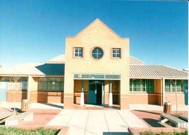
The series of photographs were taken shortly after the opening of the second Secondary College, Sunbury Downs, in Sunbury in 1987. The first high school opened in Sunbury in 1959 in the local Memorial Hall. Sunbury Downs Secondary College was built west of the town in Mitchells Lane.A coloured photograph of the main entrance to the Sunbury Downs Secondary College showing the cream and orange brick portico and terracotta and concrete paved forecourt.state education, schools, sunbury downs secondary college, ministry of education, george evans collection -
 Hume City Civic Collection
Photograph
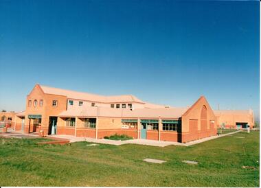
The series of photographs were taken shortly after the opening of the second Secondary College, Sunbury Downs, in Sunbury in 1987. The first high school opened in Sunbury in 1959 in the local Memorial Hall. Sunbury Downs Secondary College was built west of the town in Mitchells Lane.A coloured photograph of the cream and orange brick Sunbury Secondary College. The colourbond roof is fawn and the trimmings are aqua. A large lawn area surrounds the school buildings.state education, schools, sunbury downs secondary college, ministry of education, george evans collection -
 Hume City Civic Collection
Photograph
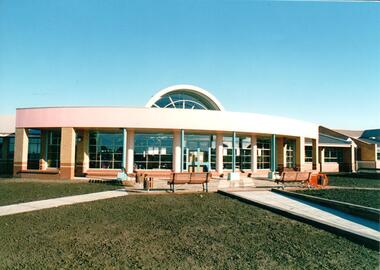
The series of photographs were taken shortly after the opening of the second Secondary College, Sunbury Downs, in Sunbury in 1987. The first high school opened in Sunbury in 1959 in the local Memorial Hall. Sunbury Downs Secondary College was built west of the town in Mitchells Lane.A coloured photograph of the rotunda like library at the Sunbury Downs Secondary College. In the front of the building there is an open area with seats and a grassed area in the immediate foreground.state education, schools, sunbury downs secondary college, ministry of education, george evans collection -
 Hume City Civic Collection
Photograph, Early 1970s
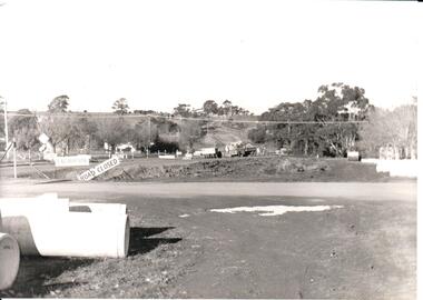
The two arch bluestone bridge which spanned the Jacksons Creek was replaced in the early 1970s with a wider double lane bridge. Dangerous curves were also taken out of the road. The area in the foreground on the RHS has now been incorporated into a public picnic area.A black and white photograph of road works taking place on the Sunbury Road over Jacksons Creek. Large concrete drain pipes are in the foreground and on the RHS of the photograph with roadwork signs on the LHS. Three trucks are at the foot of the hill.macedon street, macedon street road bridge, jacksons creek, road construction, george evans collection -
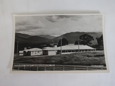 Kiewa Valley Historical Society
Photo - Tawonga District General Hospital
The hospital was transported from Bonegilla (ex-army hospital ward) and began operations in 1949. It was located at the corner of Ryder's Lane and the Kiewa Valley Highway opposite the Bogong pub. In 1961, the hospital was relocated to the centre of the Mt Beauty town in the former SEC Administration buildingThe Tawonga District General Hospital was created in the late 1940s as the local population grew as a result of the SECV constructing the KHES and the town of Mt Beauty. Prior to this, the nearest hospital was at Yackandandah and medical care was provided by medical practitioners in Mt Beauty.B & W postcard photo showing Tawonga District General Hospital in front of mountains and below a cloudy sky.Printed in white at the bottom left side "Tawonga District General Hospital" and on back "Postcard / A Genuine Photograph"tawonga hospital, medical care, mt beauty hospital., tawonga district general hospital -
 Unions Ballarat
The Paraguayan experiment, Wilding, Michael, 1984
A fictional account of the New Australia Movement, founded by William Lane in 1892. The group sought a socialist utopia and their chosen site was Paraguay. The pathway for the new community was not smooth, but the colony is still in existence. Some people formed colonies elsewhere and others returned to either Britain or Australia.Relevant to the history and development of left-wing politics and socialism in Australia.Paper; book. Front cover: white and yellow text on red background; dominant image is of the settlers amongst flowers with a hut and palm trees in the background.Front cover: author's name and title.btlc, ballarat trades and labour council, ballarat trades hall, lane, william, socialism, paraguay, utopia, new australia movement, nueva australia, politics, collective settlements, new australia co-operative settlement association -
 Bacchus Marsh & District Historical Society
Map, Gaynor Street Area Land Sales, Maddingley, 1888
This map was produced for a major sale of land in the Maddingley area of Bacchus Marsh in 1888. The sale was conducted by two firms from Melbourne, Carney and Kelly 12 Swanston Street Melbourne. and 'Richardson, Kerr & Co. 40 Flinders Lane Melbourne. 136 blocks were for sale.A single page paper map showing land allotments for sale in the Maddingley area of Bacchus Marsh. Locations shown include Gaynor Street, Maddingley Road South, Parwan Road, Mitchem Street, Typpynge Street, Finn Street and East Maddingley Road. . The map is pasted into a bound volume containing 76 maps or plans in total. High resolution digital image stored on BMDHS computer network. bacchus marsh victoria maps, maddingley victoria maps, land use, maddingley victoria history, land sales bacchus marsh, land sales maddingley -
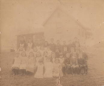 Sunbury Family History and Heritage Society Inc.
Photograph, Bulla Primary School 1893
The photo of the students at Bulla State School No. 45 was taken in 1893. The school was erected in stages in School Lane. The bluestone building was the first to be built followed by the weatherboard building and a teacher's residence. It closed in 1996 and is now a private residence. Details of the people on a typed sheet is included with the MediaBulla State School No. 46 was one of the first schools to be established in the district.A non-digital very old sepia photograph of an old photograph of children seated in front of a small weatherboard school, their teacher is standing behind the pupils. he photograph has been backed onto thick cardboard.bulla state school, schools, school lane -
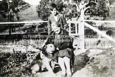 Eltham District Historical Society Inc
Photograph, Beatrice Arrowsmith (nee Quigley) and Robert Arrowsmith and King the dog at front gate of 523 Main Road, Eltham
View is looking south west from inside the front gate. Main Road is running across the picture just past the trees and the open area is where the current day Fitzsimons Lane runs. Porter street is adjacent to the property on the right of image. Robert was a POW in ChangiShows the area of Fitzsimons Lane prior to developmentBlack and white photograph - digital fileeltham, main road, fitzsimons lane, porter street, castledine, beatrice arrowsmith (nee quigley), king (dog), robert arrowsmith, joan castledine collection -
 Ringwood and District Historical Society
Photograph, Harry Tortice's wood yard and old lane now Civic Place, Ringwood. Undated
Written on back of photograph, "Harry Tortice's wood yard and old lane now Civic Place. Flat roof is entrance to Midway Arcade." Stamp on back of picture reads, "John Gallagher, Photography, 4 Benares St., Mitcham, Vic." -
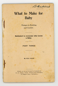 National Wool Museum
Book, Knitting, What to Make for Baby
This book and a number of others like it were owned by the mother and aunts of the donor, Mrs Dorothy Boyle. They were prolific producers of hand knitted and hand made items of clothing and also knitted and sewed for the armed forces during the Second World War. This book contains patterns for baby clothes and was written by Ella Allan who authored numerous patterns books from c.1917 through to the early 1930s.What to Make for / Baby / Designs in Knitting / and Crochet. / Dedicated to everyone who Loves / a Baby. / PART THREE / By ELLA ALLAN / Wholly set up and Printed in Australia by / E.H. GIBBS & SONS, Printers and Publishers, / 19 Niagara Lane, Melbourne.knitting handicrafts - history crochet, allan, ella, knitting, handicrafts - history, crochet -
 City of Kingston
Pamphlet - Colour, Farrow Falcon Press, Printers, Ozone Estate, Bluff Road, Hampton, c.1940
Sales plan for land in the suburb of Hampton (Highett), bounded by Bluff Road, Wickham Road, Peterson Street and June Street. Includes Morley Street, Follett Avenue, and Parrett StreetThe developing urban area of Highett within the City of Kingston. This land sale pamphlet illustrates the subdivision of land within the municipality and the changing demographic of the district as new houses are constructed close to infrastructure.Colour pamphlet advertising for private sale the Ozone Estate, Bluff Road Hampton. Incorporates a map of the estate bordered by Bluff Road, Wickham Road, June Street and Peterson Street including Morley Street, Follett Avenue and Parrett Street.Handwritten in grey pencil on reverse: Ozone Printed in purple ink on front top right-hand corner: Vendors are - Leslie Harcourt MacGowan, Esq / Neerim Road, Caulfield / & / Arthur Alfred Parrett, Esq / 311 Flinders Lane / Melbourneland sales, estate, hampton, highett -
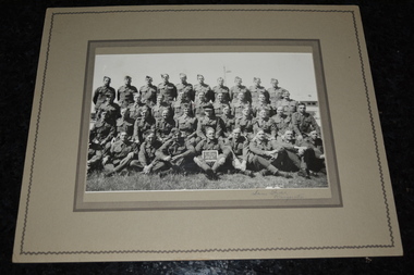 Wangaratta RSL Sub Branch
Photograph, Lanes Studio, C Coy No 4
Black and white group photograph depicting 4 rows of soldiers taken by Lane Studios of Wangaratta. Soldier in middle of front row holding chalk board. Image most likely one of four rifle companies that comprised the 2/24 Battalion which was formed in Wangaratta in 1940Black and white photograph mounted on beige colored cardboard depicting two rows of soldiers standing and two rows sittingC Coy No 4c coy no 4, wangaratta, 2/24 battalion, 1940 -
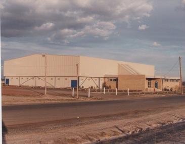 Sunbury Family History and Heritage Society Inc.
Photograph, c1980s
The building in the photograph is the recently built stadium which is part of the Boardman Reserve Sporting Complex in Mitchells Lane. This complex caters for Australian Rules Football, basketball, netball and other community sporting activities for the Sunbury Community. The stadium was built during the 1980s when the town's population was on the increase.A coloured photograph of a large colour bond building with a brick annex side at the entrance of a reserve.boardman reserve sporting complex, australian rules football, basketball -
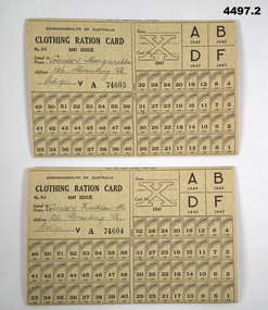 Bendigo Military Museum
Card - CLOTHING RATION CARD 1947, Commonwealth of Australia, 1947
These cards appear to be tear off from larger sheets, dotted line tear is still visible.Clothing ration cards, Commonwealth of Australia 1947 issue, yellowish colour, all print in black, folds in half, left hand top has details re card no , space for name and address issued to, cards are intact no use, each has 56 coupons, rear has details on returning lost cards to the deputy Director Rationing cavendish House 159 Flinders lane Melbourne..1) Card no 74603, in black pen, “Guiney Margaretta 126 Sternberg St Bgo”. .2) Card No 74604, in black pen, “ Guiney Kathleen M 126 Sternberg St Bgo” (Bgo means Bendigo)clothing, ration cards -
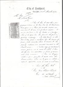 Bendigo Historical Society Inc.
Document - BENDIGO CEMETERIES COLLECTION: NOTICE OF REMOVAL OF BODIES FROM BRIDGE LANE CEMETERY
Photocopy of announcement that appeared in newspaper in 1872. The City Council having ordered the removal of the remains of bodies from the disused Cemetery in Bridge lane, the friends of the deceased are requested to communicate their wishes as to which denomination in the Sandhurst cemetery the re-internment is to be made. Geo. A. Fletcher, Town Clerk 26th November, 1872. Also six photocopies of handwritten correspondence from the City of Sandhurst signed by Geo. A. Fletcher.bendigo, cemetery, bendigo cemetery -
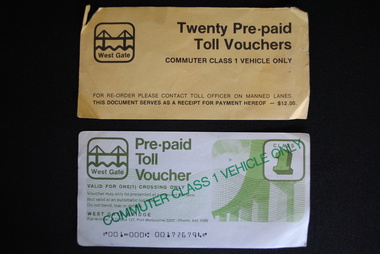 Anglesea and District Historical Society
Toll Vouchers, West Gate Bridge Authority, Estimated 1980
6 x Pre-paid Toll Vouchers valid for commuter class 1 vehicle only. Valid for one crossing of the West Gate Bridge. 1 x Cover (yellow) - Twenty Pre-paid Toll Vouchers. Commuter Class 1 Vehicle Only. For Re-order please contact Toll Officer on Manned Lanes. This doument serves as a receipt for payment hereof - $12.00.Pre-paid / Toll Vouchers / COMMUTER CLASS 1 VEHICLE ONLY / West Gate Bridge / Re-order - P.O. Box 127, Port Melbourne 3207 Phone 645 1599. West Gate Bridge symbol. toll, pre-paid voucher, melbourne, transport freeways, road bridges, west gate -
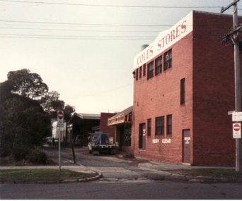 Whitehorse Historical Society Inc.
Photograph, Enterprise Way, 13/06/1986 12:00:00 AM
2 Coloured photos of Enterprise Way - Right-of-way B/N Brittania Street and Mitcham Road. This lane ran between the rear of shops on Whitehorse Road and the Mitcham Primary School (Lower School). Demolition of the school made way for Coles/New World Supermarket and several shops on Whitehorse Road made way for Original Coles Variety Store (facing Whitehorse Road) in foreground.coles variety store -
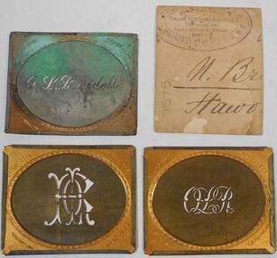 Bendigo Historical Society Inc.
Plaque - Three Brass Engraved Stencils
Oliver Lewis Randell (1836-1/7/1899) was a Welshman who began in Ballarat in the 1860's before moving to the Bendigo goldfields in 1871. He was a speculator and one of the first members of the Bendigo Stock Exchange. He had large stock holdings throughout the state, including at the time of his death, 2000 shares in the New Chum Mining Co., and 1000 shares in the North Duke Mining Co., both of BendigoThree metal stencils. Brass frame with gold outer edge and oval shape in centre. Name O.L.Randall in one stencil and two with initials OLR in centre. Bailey Bros in left hand corner Engravers in right hand corner Chancery Lane in bottom left hand corner London WC in bottom right hand corner. Cardboard square with Logo on engraver in purple inkstencils, o.l. randall -
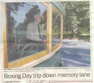 Ballarat Tramway Museum
Newspaper, The Courier Ballarat, "Boxing Day trip down memory lane", 27/12/2004 12:00:00 AM
Newspaper clipping from The Courier, 27/12/2004 titled "Boxing Day trip down memory lane". Photo of Peter Winspur driving No. 27 across Wendouree Parade to start the resumption of services following the installation of the replacement Isolating Transformer. Article written by Monique Patterson. Article notes the 30th anniversary of BTPS/BTM Operations, transformer, fund raising and tram services.btm, substation, reopening, 30th anniversary -
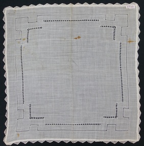 Flagstaff Hill Maritime Museum and Village
Accessory - Handkerchief, 1876
The handkerchief was made and owned by Mary Ann Simmons, born about 1857 in Cuckfield, Sussex, England. She died in 1914 in England. It was then owned by Edith Mary Etherton (nee Upton) born 10-2-1888 at Chatfield Cottages, London Lane, Cuckfield, Sussex, England. Mary died in Yarram, Victoria, Australia 29-3-1969. The next owner was Edith Mary Lodge (nee Etherton) aka Mary Coxedge, born 10-2-1959 at Chatfield Cottages, London Lane, Cuckfield, Sussex, England. She died in December 1998 at Nagambie, Victoria, Australia. The family moved to Australia in 1922. The last owner was Nancy Mavis Lambrick (nee Lodge) born 25-7-1937 at Tarralgon, Victoria, Australia. The handkerchief is a very good example of fine drawn thread handmade needlework and handed down through the family over generations. Ladies handkerchief. Hand worked, fine cotton, off-white coloured handkerchief. Drawn thread work with bobbin lace edging. C. 1876flagstaff hill, warrnambool, shipwrecked coast, flagstaff hill maritime museum, maritime museum, shipwreck coast, flagstaff hill maritime village, great ocean road, handmade handkerchief, fine cotton handkerchief, drawn thread work handkerchief, ladies handkerchief, mary ann simmons, edith mary lodge (nee etherton), mary coxedge, nancy mavis lambrick, chatfield cottages, london lane, cuckfield, sussex, england, drawn thread work -
![Photograph - Digital image, John and Rosalie McLaughlin [grave], 05/10/1933](/media/collectors/4f729f5697f83e03086015b8/items/543ce58e2162f103802c594f/item-media/543ce6962162f103802c6369/item-fit-380x285.jpg) Greensborough Historical Society
Greensborough Historical SocietyPhotograph - Digital image, John and Rosalie McLaughlin [grave], 05/10/1933
Photograph of the grave of John and Rosalie McLaughlin. The McLaughlin family came to Greensborough circa 1840 from Belfast. In 1865 the family moved to Whittlesea. McLaughlins Lane Plenty is named after the family. The McLaughlin family was related to the Black family of Watsonia by marriage. Rosalie died 30/09/1953.Digital copy of colour photograph.mclaughlin, john mclaughlin, caroline mclaughlin -
 Greensborough Historical Society
Newspaper Clipping, Diamond Valley Leader, Perk hour traffic, 30/08/2017
A storm in a coffee cup is brewing on busy Diamond Creek Road. Every time a motorist stops for a morning caffeine fix, six lanes of traffic grind to a standstill. Sensors installed at St Sava Serbian Church trigger traffic lights which allow the car in the carpark to enter traffic.News article 1 page, black text.greensborough, coffee stop, diamond creek road, nillumbik council, st sava serbian orthodox church -
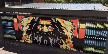 City of Ballarat
Artwork, other - Public Artwork - Temporary, Roots by Josh Muir, November 2019 - March 2020
Old uncle is standing on the mountainside watching over the modern-day empires built on Aboriginal land shaking his head, saying: “they are doing it again, every empire has a rise and fall”. It’s something that has never been learnt over time. — Josh Muir Josh Muir’s work, Roots, was the first temporary artwork to be installed on the Gallery Annex Wall on the approach to Alfred Deakin Place, Police Lane in Ballarat Central. The space is an important site to host this work given that Alfred Deakin Place is commonly used as a place of discussion, engagement, protest and performance.Temporary artwork - printed vinyl application to concrete wallnoneelder, aboriginal and torres strait islander -
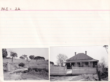 The Beechworth Burke Museum Research Collection
Card (Series) - Index Card, George Tibbits, Pritchard Lane or Gorge Road, Beechworth, 1976
George Tibbits, University of Melbourne. Faculty of Architecture, Building and Town & Regional PlanningIndex system that support the research for Beechworth : historical reconstruction / [by] George Tibbits ... [et al]Arranged by street names of BeechworthEach index card includes: street name and number of property, image of property, allotment and section number, property owners and dates of ownership, description of the property according to rate records, property floor plan with dimensions.beechworth, george tibbitsbeechworth, george tibbits