Showing 946 items
matching ownership
-
 Kew Historical Society Inc
Postcard, Kew Police Station, c.1960
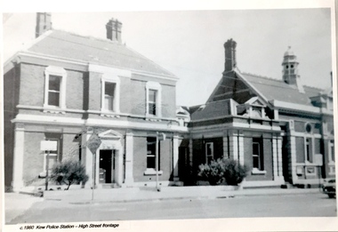
In c.1960, when the photograph was taken on which the postcard is based, both buildings were still owned by the Victorian Government and were a functioning police station and court house. In 1900, ownership of the post office had been transferred to the new Commonwealth Government. In the first decade of the twenty-first century, the police station and court house were offered for sale. They were subsequently purchased and renovated by the City of Boroondara. The Kew Historical Society raised over $5000,000 as a contribution to the restoration.Kew Police Station at left and Kew Court House at right. Monochrome (copied) postcard showing two buildings which are part of a larger complex (once including a post office) built by the Government of Victoria in 1888. The buildings are located at the junction of High Street and Cotham Roads in Kew. The frontages shown face High Street. "c.1960. Kew Police Station. High Street Frontage"kew court house -- high street -- kew (vic.), kew police station -- high street -- kew (vic.), public offices -- kew (vic), queen ann revival -- architectural style -
 The Beechworth Burke Museum Research Collection
Card (Series) - Index Card, George Tibbits, 13 William Street Beechworth, 1976
George Tibbits, University of Melbourne. Faculty of Architecture, Building and Town & Regional PlanningIndex system that support the research for Beechworth : historical reconstruction / [by] George Tibbits ... [et al]Arranged by street names of BeechworthEach index card includes: street name and number of property, image of property, allotment and section number, property owners and dates of ownership, description of the property according to rate records, property floor plan with dimensions.beechworth, george tibbitsbeechworth, george tibbits -
 Ballarat Tramway Museum
Document - Report, City of Ballaarat, "Submission to Enquiry into Public Transport Facilities in the Ballarat Urban District by A. W. Nicholson, Mayor of Ballaarat Council", Apr. 1968
Yields information about the view of the City of Ballaarat in 1968 about the possible replacement of tram service.Report or Submission - 6 Gestener printed foolscap sheets, stapled on left hand side and bound with a blue edging tape titled "Submission to Enquiry into Public Transport Facilities in the Ballarat Urban District by A. W. Nicholson, Mayor of Ballaarat Council". Dated 2 April 1968. Submission looks at the possible closure or the future of the tramway system, the SEC involvement, employment, road surface repairs, financial loss to the SEC, reduction in passengers due to car ownership. Council submitted that the tramway system should be retained and extended and that pensioner concessions should be continued. Notes that at the time 69 men on the trams, 18 at the depot and 8 on the track. If replaced by buses, supported a government owned bus provider rather than private. Document scanned - word searchable. pdftrams, tramways, closure, city of ballaarat, bus replacement, public transport, sec, finances -
 Bendigo Historical Society Inc.
Document - MINING REPORTS - BOILERS INSPECTION ACT 1928
Printed document Inspection and Regulation of Boilers, dated 12th February 1929, No 3645 which sets out rules and regulations for the ownership and use of boilers. Items mentioned are: Inspectors, Registration of Boilers, Inspection of Boilers, Certificate of Inspection, Powers and Duties of Inspectors, Necessity for Certificate, Notice f Alterations, Duties and Liabilities of Owners of Boilers and Others, Explosions and Accidents and Miscellaneous. Also Schedules. First Schedule is the Number and Title of Act, Second Schedule is Notice of Registration, Third Schedule is Certificate of Inspection, Fourth Schedule is certificate stating the number of lbs. per square inch the safety valve blows off, Fifth Schedule is Notice to Owner that Boiler is Dangerous and Sixth Schedule is a Report with regard to Explosion of or Accident causing damage or injury to a Steam Boiler. Document is part of the Albert Richardson Collection. document, mining reports, boilers inspection act 1928, t rider -
 Warrnambool and District Historical Society Inc.
Photograph - Don Jenkins - Woollen Mill
Don Jenkins was the Managing Director of the Warrnambool Woollen Mill from 1971 to 1989. He was first employed at the Woollen Mill in 1935. The Warrnambool Woollen Mill in South Warrnambool was established in 1910 with the first manager, J.E. Bennett. By 1915 there were 160 employees and in 1969 there were 380 employees. In 1980 acrylic blankets and fabrics were made on the site and in 1982 there was a name change to Warrnambool Textiles. In 1995 the Smith Family took over the factory, following its ownership by several other Australian firms. It closed in 2000. This is an important photograph as the Warrnambool Woollen Mill was a prominent business in Warrnambool for 90 years. Don Jenkins was the Managing Director for 19 years and this is a good photograph of him and is very useful for display and research purposes. This is a colour photograph of Don Jenkins in a wooden and gilt edged frame with a linen insert. On back of photograph handwritten in biro – ‘Don Jenkins, Managing Director, 1970-1988?’ (Note that Mr Jenkins was the Managing Director from 1971 to 1989)warrnambool, woollen mill, don jenkins, manager warrnambool woollen mill -
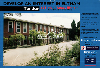 Eltham District Historical Society Inc
Document, Tender Documents for purchase of Former Eltham Shire Offices 895 Main Road, Eltham, April 1996, 1996
Graeme Hardiman Real Estate Prepared for Nillumbik Shire Council Maddock Lonie & Chisholm, 140 William Street, Melbourne Tenders closed at 3.00pm on 24 April 1996 Whilst the sale of the former Shire Office site went through and the Shire Commissioners approved the demolition of the building several months later in the year, ongoing community protests and objections eventually led to the reversal of the sale. Despite several further attempts to sell the site and community protests as recent as 2019, the vacant land remains in Council ownership.89 A4 pages; 1 x glossy paper with photo and 88 x photocopied pageseltham shire office, graeme hardiman first national real estate, maddock lonie & chisholm, nillumbik shire council, real estate, tenders -
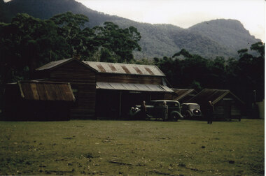 Halls Gap & Grampians Historical Society
Photograph - Coloured
The main building and chalets were built by E. C. Mitchell of Stawell. He was given a 99 year lease by the shire to build his holiday house at the site of Borough Huts. David and May Mitchell took over ownership of the house and chalets. The women in the photo are May and Isabel Mitchell and the man is David Mitchell. The chalets were called "Flappers Roost", "Bower of Innocence" and "Last Resort". The two copies of the photo are taken from slight closer in and are not as clear and do not show the entire third chalet.The photo shows a collection of old buildings. Two women are standing in front of a car and a man is standing a short distance from them. A second car is parked between the main building and the huts. The building to the far right of the photo is painted in a cream colour and has a tin chimney. The other buildings are three small huts or chalets. Gum trees and a mountain range can be seen directly behind the buildings.buildings, houses -
 Federation University Historical Collection
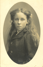
Photograph - Photograph - black and white, Iris
On her husband, William's, death in 1914, Violet Holmes inherited 'Sauchieburn’ property in the Ascot District of the Wider Ballarat District, Victoria. Her ownership had descended via the Holmes Family from the pioneer district settler/squatter Captain William Coghill. In turn, the property on Violet's death was left to their family: Violet Spittle (nee Holmes), Mary Holmes, William E. Holmes and Henry Smerdon Holmes. I suspect this photo was sent to Violet Holmes Jnr (m Spittle) [Jane Dyer 2024]Photographic portrait of a girlVerso: Dear Mary, I am sending one of my photos and hope you will like it. Please get your taken and send me one and ask Violet and the boys also. Mother and Daphne send their love to all. From Iris.chatham-holmes family collection, family history, women -
 The Beechworth Burke Museum Research Collection
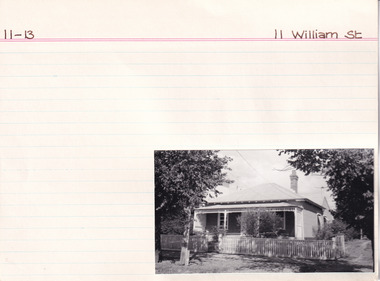
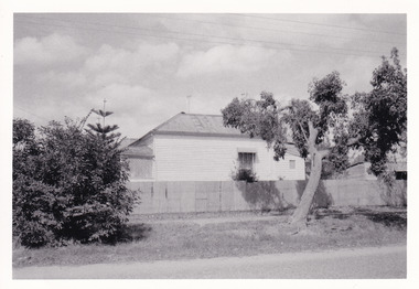
Card (Series) - Index Card, George Tibbits, 11 William Street, Beechworth, 1976
George Tibbits, University of Melbourne. Faculty of Architecture, Building and Town & Regional PlanningIndex system that support the research for Beechworth : historical reconstruction / [by] George Tibbits ... [et al]Arranged by street names of BeechworthEach index card includes: street name and number of property, image of property, allotment and section number, property owners and dates of ownership, description of the property according to rate records, property floor plan with dimensions.beechworth, george tibbitsbeechworth, george tibbits -
 The Beechworth Burke Museum Research Collection
Card (Series) - Index Card, George Tibbits, 14 William Street Beechworth (cnr Last St), 1976
George Tibbits, University of Melbourne. Faculty of Architecture, Building and Town & Regional PlanningIndex system that support the research for Beechworth : historical reconstruction / [by] George Tibbits ... [et al]Arranged by street names of BeechworthEach index card includes: street name and number of property, image of property, allotment and section number, property owners and dates of ownership, description of the property according to rate records, property floor plan with dimensions.beechworth, george tibbitsbeechworth, george tibbits -
 The Beechworth Burke Museum Research Collection
Card (Series) - Index Card, George Tibbits, Cnr William and Woods Streets, Beechworth, 1976
George Tibbits, University of Melbourne. Faculty of Architecture, Building and Town & Regional PlanningIndex system that support the research for Beechworth : historical reconstruction / [by] George Tibbits ... [et al]Arranged by street names of BeechworthEach index card includes: street name and number of property, image of property, allotment and section number, property owners and dates of ownership, description of the property according to rate records, property floor plan with dimensions.beechworth, george tibbitsbeechworth, george tibbits -
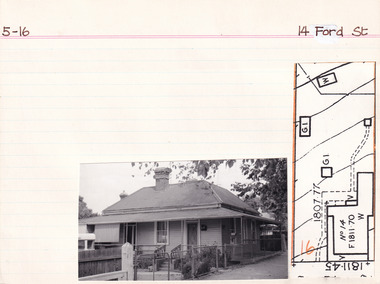
 The Beechworth Burke Museum Research Collection
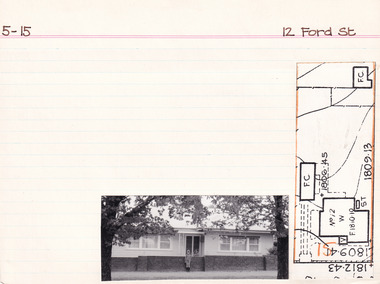
Card (Series) - Index Card, George Tibbits, 12 Ford Street, Beechworth, 1976
George Tibbits, University of Melbourne. Faculty of Architecture, Building and Town & Regional PlanningIndex system that support the research for Beechworth : historical reconstruction / [by] George Tibbits ... [et al]Arranged by street names of BeechworthEach index card includes: street name and number of property, image of property, allotment and section number, property owners and dates of ownership, description of the property according to rate records, property floor plan with dimensions.beechworth, george tibbitsbeechworth, george tibbits -
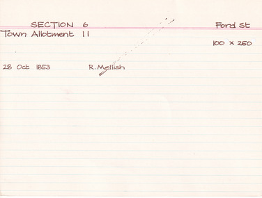 The Beechworth Burke Museum Research Collection
Card (Series) - Index Card, George Tibbits, Ford Street, Beechworth, 1976
George Tibbits, University of Melbourne. Faculty of Architecture, Building and Town & Regional PlanningIndex system that support the research for Beechworth : historical reconstruction / [by] George Tibbits ... [et al]Arranged by street names of BeechworthEach index card includes: street name and number of property, image of property, allotment and section number, property owners and dates of ownership, description of the property according to rate records, property floor plan with dimensions.beechworth, george tibbitsbeechworth, george tibbits -
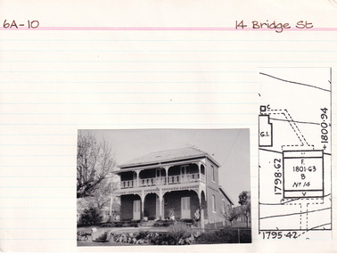 The Beechworth Burke Museum Research Collection
Card (Series) - Index Card, George Tibbits, 14 Bridge Street, Beechworth, 1976
George Tibbits, University of Melbourne. Faculty of Architecture, Building and Town & Regional PlanningIndex system that support the research for Beechworth : historical reconstruction / [by] George Tibbits ... [et al]Arranged by street names of BeechworthEach index card includes: street name and number of property, image of property, allotment and section number, property owners and dates of ownership, description of the property according to rate records, property floor plan with dimensions.beechworth, george tibbitsbeechworth, george tibbits -
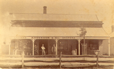 Bacchus Marsh & District Historical Society
Photograph, Anderson's Store, Main Street, Bacchus Marsh circa 1870s-1890s
This store in Main Street Bacchus Marsh was first opened by James Young in November 1866. In October 1869 it was purchased by William Anderson and was operated by members of the Anderson family until 1971. The site of the store was on the southern side of Main Street on the eastern side of Eddie Toole Park. On the opposite side of the street was the site of the former Post Office on the northern side of Main Street. The store was first named the Border Mills Store during James Young's ownership and was later known as the Border Store (Anderson & Co.).Small black and white photograph showing Anderson’s store. It shows a large stone building with a corrugated iron verandah which bears a painted sign of the name of the business: GROCERS. ANDERSON & Co. DRAPERS. Behind a brick parapet rises a hip roof with one chimney visible. Four men stand in casual poses ranged along the verandah. A post and rail fence runs along the road frontage. A tree is planted in an ornamental wrought iron plant protector on the inside of the fence.On the back in decorative print: “ New York Photographic Adelaide Travelling Brand Chas. F. Husband Manager.” In handwriting: Border store built by James Young 1866 owned by Anderson 1869-1972. BMDHS stamp and no. HS 411.shops bacchus marsh vic., anderson's store bacchus marsh, stevenson and mcnicoll 1883 photographs of bacchus marsh and district -
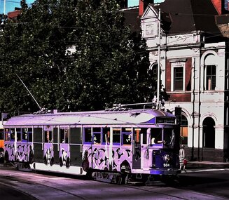 Ballarat Tramway Museum
Functional Object - Tramcar, Melbourne and Metropolitan Tramways Board (MMTB), Tramcar 504, 1928
A four motor bogie drop centre combination tram of the Melbourne W2 class. Body built by the James Moore and Co. of South Melbourne as a W2 class tram. Delivered to the MMTB Preston Workshops where the electrical and mechanical equipment was fitted. Issued to traffic 18/4/1928. Allocated to Essendon Depot. The tram was part of the Transporting Art project suggested by the artist Clifton Pugh (1924-1990) in Jan. 1978 to the Lord Mayor of Melbourne Cr. Irvin Rockman. The concept was enthusiastically supported by Victorian Premier Rupert Hamer. Clifton Pugh's tram was the second tram to appear. Described by the artist as "The apostle birds in flight, as if the tram has run into a group of them and they're flying along the sides. Then I found the route was to be through Collingwood and Hawthorn football territory and one cannot be one-eyed in that worlds, there are a magpie and a hawk on each side." The tram was retained by the State and stored until 2015 when it was transported to the Museum's Offsite store. Formal ownership was transferred to the Museum during 2019. Conservation planning for the tram's return to service and the restoration of the artwork is underway. 1986 - withdrawn from service following a minor accident and stored. In 2015 tram relocated to the Museum's offsite store and during 2019 transferred to ownership of the Museum. See btm.org.au/trams/504.html for further detail. Photos - i1 - Ray Marsh 1978 i2 - Alastair Reither - 3/6/2015 showing the damaged side. i3 - Clifton Pugh on board his tram. Photo from the Diners Club Signature Magazine April/May 1982, from an article titled Moving Masterpieces. Photo courtesy of the Melbourne Tram Museum. See Destination Citytrams, w2 class, transporting art, tram 504 -
 Warrnambool and District Historical Society Inc.
Document, Grasmere Church Dispute, 1882
These papers contain cuttings newspaper articles from the Standard of 1882 and handwritten comments appended to these cuttings. They refer to a dispute in 1882 regarding the ownership of the church in Grasmere to which the Anglican Church was claiming ownership The author of the handwritten comments is unknown but the comments purport to be a more accurate account of events than what appears in the paper cuttings. Grasmere is a small settlement 10 kilometres north of Warrnambool. In the 1850s land in Grasmere was donated for educational purposes and a Government-subsidized school which was a Denominational School run by the Church of England was established in 1858. This school was closed when Government State Schools were established after 1872 and the Anglican Church dismantled the old school and built a church on the site in the late 1870s. This church was erected by public subscription and many of the subscribers apparently believed they were donating to a building that could be used by any local Protestant churchgoers. The church in 1882 was being used by the Presbyterian Church for its services. A public meeting was held in 1882 to try to resolve the dispute between the Anglican Church claim and the local residents’ claim that the site belonged to the local community. Apparently the dispute remained unresolved and the Grasmere Anglican Church continued to operate until the early 20th century. This document is of interest as it is associated with a dispute that took place in Grasmere in 1882 and gives some indication of the arguments that were presented at the time in favour of, or opposed to, the Anglican Church’s claim to the ownership of the church. It is a document of particular interest to the history of the Grasmere. This is a folder of eleven foolscap-size sheets of paper enclosed in a mottle-coloured cardboard cover. The front cover is creased and partly torn and the back cover is detached and is in two pieces. The pages have been stitched together with thread and contain paste-in newspaper cuttings and handwritten material in purple ink. Grasmere Anglican Church -
 Orbost & District Historical Society
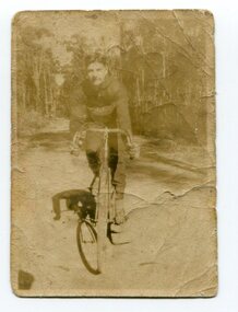
black and white photograph, 1920 - 1930
By 1905 there was an Orbost Bicycle Club. E. Donchi was a member and was a successful competitor around 1927. It is likely that the Orbost Cycling Club disbanded during WWI, and evidence from the Snowy River Mail is that it reformed again in 1945. There is no doubt that bikes were a dominant form of personal transport until the 1960s when cars ownership became more common, although children still rode to school. As far as theOrbost Cycling Club was concerned, the golden years were from 1945 to 1950. (information Newsletter August 2018 - Geoff & Lee Stevenson)This item is associated with a popular recreational activity in early Orbost. The period between the First World War and the 1950s was the heyday of cycling. After 1900 the efficient mass production of standardized safe bicycles, as well as the wider availability of second-hand bicycles, caused rapidly dropping prices and it was therefore easier for people to purchase a bicycle not only for utilitarian use but for racing. A small black / white photograph of a young man on a racing bike. It is on an unsealed road in a forest. on back - "E. Donchi, Cyclist, Orbost"donchi cycling-orbost recreation -
 Glen Eira Historical Society
Letter - Eskdale Road, 90, Caulfield North
A one page handwritten letter from Alan Douglas to the Glen Eira Historical Society, dated 19/02/04, regarding his donation of eleven professional photographs of the interior, exterior and garden at 90 Eskdale Road, Caulfield, taken by Muntz Studios, possibly in the 1920s. The letter also provides brief details of ownership of the property. Also included is a one page typed reply from the Glen Eira Historical Society, dated 23/03/2004. The file also includes the eleven black and white photographs (130mm x 202mm) of the property.jones james norman, jones winifred gardner, davies winifred, eskdale road, caulfield, caulfield north, douglas alan, douglas barbara kathleen, livingstone-muntz d, muntz studios pty ltd -
 Eltham District Historical Society Inc
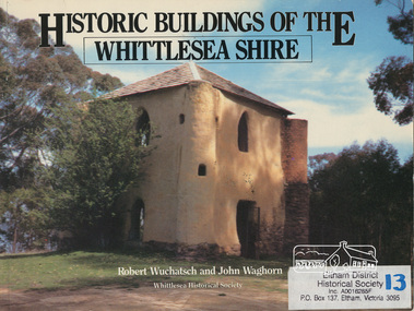
Book, Robert Wuchatsch 1950- et al, Historic buildings of the Whittlesea Shire / Robert Wuchatsch and John Waghorn, 1985
Historical accounts of 55 buildings which portray the Shire of Whittlesea's diverse history. Contains 70 photographs, all full page, 12 in colour. Each is accompanied by a comprehensive account of the homes' origins and changing ownerships through the generations. There are also drawings and a map of the Shire of Whittlesea. Reference to the Peter Lalor Home Building Co-Operative Society Ltd., a project devised to overcome the critical shortage after World War 2. Produced as part of the celebrations for Victoria's 150th anniversary by the Whittlesea Historical Society. A photograph of Bear's Castle at Yan Yean Reservoir is on the cover.Paperback; [114] p. : ill. (some col.), 1 map ; 19 x 25 cm.ISBN 0958866309buildings, shire of whittlesesa, bear's castle -
 Ringwood and District Historical Society
Pamphlet, Ringwood Council's Annual Report To The Ratepayers - December 1968, 1968
City of Ringwood community information annual report for 1968, including sections covering Finance, General Valuation and Rater Payments, Property Ownership Changes, Refuse, Sanitary Serviced, Sewerage Connections to MMBW, Dandenong Valley Authority, Residential Flat Control Planning Scheme, Immunisation, Home Help, Elderly Citizens' Clubrooms, Library, Civic Centre, Golf Course, Sale of Council Land, Swimming Centre, Holiday Play Centre, Civic Week, Lake Reserve Improvements, Rubbish Dumping, Street Trees, Vandalism, White Ants, Street Construction, Fire Hazards, Dog Nuisance, House Numbering, Citizens' Advisory Service, Infant Welfare Centres, and a list of departing and current Council Representatives. Also includes general reminders regarding rat extermination, free firewood for age pensioners, overhanging vegetation, and spouses voting rights.Obituary - Mr. F.P. Dwerryhouse, Town Clerk for the past 9-1/2 years passed away on 6th December after a short illness.rinx -
 Melbourne Tram Museum
Pamphlet, Minister of Transport, "Transport Safeguards", "New Guarantees for Public Transport Passengers effective mid 1999", "A New Partnership - Reforming Victoria's trains and trams: what it means for public transport employees", 1998 - 1999
Set of three items related to the decision to franchise the public transport in Melbourne during late 1998. Items are related to Reg Item 2830. a report titled "A system into a Service" by the Victorian Government late 1998. .1 - photocopy of a newspaper article in The Age 30/10/1998 titled "Transport Safeguards" written by Lyall Johnson giving details of the Passenger Charter, guarantees, quotes Robin Cooper, Minister for Transport. Has a cartoon by Tandberg. .2 - Pamphlet - 4 fold DL titled "New Guarantees for Public Transport Passengers effective mid 1999" detailing the Passenger charter. .3 - Pamphlet - 3 fold DL titled "A New Partnership - Reforming Victoria's trains and trams: what it means for public transport employees", outlining the corporate structure, franchising and private ownership, guarantees for employees and passengers. Not dated.trams, tramways, public transport, franchising, ptc, privatisation, passengers, minister for transport, cartoons, passenger services -
 Seaworks Maritime Museum
Shipbuilders model, Era
Model of the Era. Oil tanker built by Samsung Ship Building and Heavy Industries Company in South Korea. Completed January 1987. 1985 officially under ownership of Howard Smith Industries Pty Ltd, Melbourne with take over of R W Miller. 1996 transferred to Intercontinental Ship Management. Scrapping began at Alang January 2002. 54 880 gross tons Length overall: 229.732 m (758 ft) Beam (MLD): 46 m (151 ft) Depth (MLD): 19.2m (46 ft) Draught (design): 12.17 m Draught (Scantl): 13.6 mShip builder's model of the tanker Era IMO 8420218 built by Samsung Shipbuilding & Heavy Industries Co. - Moulded polyurethane hull painted in colours of black and maroon, the deck with detailed fittings, machinery and superstructure, presented within a perspex display case. Scale 1:200plaque at foot of model: "95,000 DWT CRUDE/ PRODUCT CARRIER/ PRINCIPAL DIMENSIONS/ LENGTH O.A 229.732M/ LENGTH B.P 220.000M/ Breadth (MLD.) 46.000M/ DEPTH (MLD.) 19.200 m/ DRAUGHT (DESIGN) 12.170 M/ DRAUGHT (SCANTL.) 13.600 M/ SHI SAMSUNG SHIPBUILDING &/ HEAVY INDUSTRIES CO., LTD./ SCALE OF MODEL 1:200" White pen written on base: "PWO 2666.4/ 110/97/S4" Label affixed to base: "104226" on model "ERA MELBOURNE/TUG/TUG/TUG/NO SMOKING/NO SMOKING/ ERA" -
 Glen Eira Historical Society
Medal - QUEEN VICTORIA JUBILEE 1887
This file contains 2 items relating to an 1887 Queen Victoria Jubilee Medal: 1/An 1887 Queen Victoria Jubilee Medal. The medal has an image of Queen Victoria and the words ‘Victoria’s Jubilee 1887’ on one side, and the Australian Coat of Arms with the words ‘Caulfield’s Celebration 21 June 1887’ on the other. The medal is accompanied by a card noting that it is owned by the Glen Eira Historical Society, with no other ownership details mentioned. 2/A print-out from the Museum Victoria website, containing the details of a similar medal owned by Museum Victoria. The print-out includes a photo of the obverse of the medal.festivals and celebrations, medals, caulfield, queen victoria jubilee 1887, queen victoria -
 Lake Bolac & District Historical Society
Black and white photograph, Albert Austin, "Eilyer", 1834-1916
When 'Bolac Plains' was subdivided in 1846 Henry Gibb took up the northern end and he named the property 'Eilyer'. 'Eilyer' was bought from the estate of Henry Gibb in 1864 by Josiah and Thomas Austin. Gibb had been killed the year before when he fell from a horse. At the time of purchase, 'Eilyer' was 30,000 acres in size. It was later divided up and the second section become known as "Myuna". Ownership of 'Eilyer' has remained in the same family for over 150 years: Thomas and Josiah, Albert, Ronald, Derrick, Kate (Blackburn), Michael (Blackburn).bolac plains, gibb, myuna, austin, blackburn -
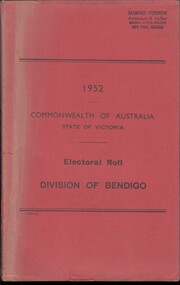 Bendigo Historical Society Inc.
Administrative record - Electoral Roll, 1915
Voting registers, or electoral rolls, are a census of those who were eligible to vote. They are valuable because a country-wide census was not taken until 1911. Early electoral rolls give an individual name, residence, status of property occupation/ownership, and the rate value of the property. Electoral rolls are arranged by electoral district and subdistrict. Name, Address, Occupation and gender for thirteen subdivisions (Bendigo, Carisbrook, Castlemaine, Eaglehawk, Elmore, Golden Square, Heathcote, Maldon, Marong, Maryborough, Raywood, Sandhurst East & Strathfieldsaye). Electoral rolls were published by each state during election years..Electoral Roll for the Commonwealth Division of Bendigo, State Assembly District of Bendigo, and State Electoral Province of Bendigo for 1952 (made up to 8th September 1952). Includes Name, Address, Occupation and gender for thirteen subdivisions (Bendigo, Carisbrook, Castlemaine, Eaglehawk, Elmore, Golden Square, Heathcote, Maldon, Marong, Maryborough, Raywood, Sandhurst East & Strathfieldsaye). Assembled and bound with string, and a red light-card cover.Stamped on cover as owned by Harold Curnow, Accountant and Auditor, Colonial mutual Building, View Street, Bendigo.electoral rolls, voting in bendigo -
 The Beechworth Burke Museum Research Collection
Card (Series) - Index Card, George Tibbits, 14 Ford Street, Beechworth, 1976
George Tibbits, University of Melbourne. Faculty of Architecture, Building and Town & Regional PlanningIndex system that support the research for Beechworth : historical reconstruction / [by] George Tibbits ... [et al]Arranged by street names of BeechworthEach index card includes: street name and number of property, image of property, allotment and section number, property owners and dates of ownership, description of the property according to rate records, property floor plan with dimensions.beechworth, george tibbitsbeechworth, george tibbits -
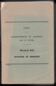 Bendigo Historical Society Inc.
Administrative record - Electoral Roll, 1915
Electoral Roll for the Commonwealth Division of Bendigo, State Assembly District of Bendigo, and State Electoral Province of Bendigo for 1967 (made up to 22nd June 1967). Voting registers, or electoral rolls, are a census of those who were eligible to vote. They are valuable because a country-wide census was not taken until 1911. Early electoral rolls give an individual name, residence, status of property occupation/ownership, and the rate value of the property. Electoral Rolls are arranged by electoral district and subdistrict. Name, Address, Occupation and gender for thirteen subdivisions. Electoral rolls were published by each state during election years. Electoral Roll for the Commonwealth Division of Bendigo, State Assembly District of Bendigo, and State Electoral Province of Bendigo for 1967 (made up to 22nd June 1967). Includes Name, Address, Occupation and gender for thirteen subdivisions. Assembled and bound with string, with a faded light green card cover..electoral rolls, voting in bendigo -
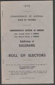 Bendigo Historical Society Inc.
Administrative record - Electoral Roll, 1915
Electoral Roll for the Commonwealth Division of Bendigo, State Assembly District of Bendigo, and State Electoral Province of Bendigo Subdivision of Eaglehawk for 1970 (made up to 2nd January 1970). Voting registers, or electoral rolls, are a census of those who were eligible to vote. They are valuable because a country-wide census was not taken until 1911. Early electoral rolls give an individual name, residence, status of property occupation/ownership, and the rate value of the property. Electoral Rolls are arranged by electoral district and subdistrict. Name, Address, Occupation and gender for thirteen subdivisions. Electoral rolls were published by each state during election years. Electoral Roll for the Commonwealth Division of Bendigo, State Assembly District of Bendigo, and State Electoral Province of Bendigo, Subdivision of Eaglehawk for 1970 (made up to 2nd January 1970). Includes Name, Address, Occupation and gender for thirteen subdivisions. Assembled and bound with staples, with a light grey card cover..electoral rolls, voting in bendigo -
 Kew Historical Society Inc
Plan, Melbourne & Metropolitan Board of Works : Borough of Kew : Detail Plan No.1576, 1904
The Melbourne and Metropolitan Board of Works (MMBW) plans were produced from the 1890s to the 1950s. They were crucial to the design and development of Melbourne's sewerage and drainage system. The plans, at a scale of 40 feet to 1 inch (1:480), provide a detailed historical record of Melbourne streetscapes and environmental features. Each plan covers one or two street blocks (roughly six streets), showing details of buildings, including garden layouts and ownership boundaries, and features such as laneways, drains, bridges, parks, municipal boundaries and other prominent landmarks as they existed at the time each plan was produced. (Source: State Library of Victoria)This plan forms part of a large group of MMBW plans and maps that was donated to the Society by the Mr Poulter, City Engineer of the City of Kew in 1989. Within this collection, thirty-five hand-coloured plans, backed with linen, are of statewide significance as they include annotations that provide details of construction materials used in buildings in the first decade of the 20th century as well as additional information about land ownership and usage. The copies in the Public Record Office Victoria and the State Library of Victoria are monochrome versions which do not denote building materials so that the maps in this collection are invaluable and unique tools for researchers and heritage consultants. A number of the plans are not held in the collection of the State Library of Victoria so they have the additional attribute of rarity.Original survey plan, issued by the MMBW to a contractor with responsibility for constructing sewers in the area identified on the plan within the Borough of Kew. The plan was at some stage hand-coloured, possibly by the contractor, but more likely by officers working in the Engineering Department of the Borough and later Town, then City of Kew. The hand-coloured sections of buildings on the plan were used to denote masonry or brick constructions (pink), weatherboard constructions (yellow), and public buildings (grey). Development in the 20th century has irreparably altered that part of Kew represented in this plan. In the block bounded by Cotham Road, Charles Street, Wellington Street and Gellibrand; just one house standing in 1903 remains. This block included two of the most historic houses in Kew: ‘Ordsall’ (later ‘Southesk’) and ‘Madford’ (previously ‘Elm Lodge’). Ordsall was the home of the second chairman of Kew, John Halfey. It contained some of the most significant interior murals in Kew, created for Halfey by artists working for Cullen & Co. It was demolished in 1960 to make way for the Kew Civic Centre. Elm Lodge had been built for William Siddeley in ca. 1864. Arthur Septimus King purchased it in 1874. The lower paddocks of Madford were sold in 1905 by his wife to the Borough of Kew and, after landscaping by George and Thomas Pockett, opened as the Alexandra Gardens in 1908. Elm Lodge/Madford was in 1922 to become St. Anthony’s Home for Little Children before its subsequent demolition in the 1980s.melbourne and metropolitan board of works, detail plans, maps - borough of kew, mmbw 1576, cartography