Showing 993 items
matching paddocks
-
 Mt Dandenong & District Historical Society Inc.
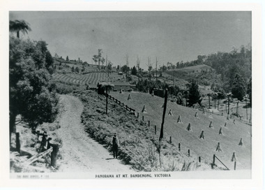
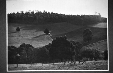
Photograph, View From Corner of Doughty's Road and Barbers Road 1913
John Lundy-Clarke grew up in the Kalorama/Mt Dandenong area and later in life (1972-74) began to write a comprehensive history of the area working from an original settlement map in an effort to cover all areas. Taken c1913, this photograph gives a clear indication of where significant buildings were located in relation to one another. Barbers Road is running through the picture with the guest house 'Kia-Ora' , built by George Barber in the centre. High on the skyline on the left is the 'Mountjoy' guesthouse, indicating the location of The Gap, or FiveWays. The small 'boxy' house above 'Kia-Ora' is 'Iona' built by the Paynter family who also built 'Mountjoy'. The Jeeves property 'Kalorama' is to the right of 'Iona' and this is the area you now look to from the FiveWays Lookout. The man in the photo is wearing a trilby hat so is probably a Rose Series employee - a feature in many Rose Series postcards.Black and white photograph that is a copy of Rose Series Postcard # 156. A man can be seen walking down an unmade road with haystacks to his right. Buildings and crops can be seen on the hillsides. Handwritten inscription on reverse by John Lundy-ClarkeView from corner of Doughty’s and Barbers Road 1913. “Kia Ora” in centre Paynter’s “Iona” near center skyline above “Kia Ora” with “Kalorama” on its right and Peter’s hut of the time below it among orchard trees. “Mountjoy” is on left skyline. W. Haye’s home is centre left. Hay paddock is Barbers Lot 25 Village Settlement.kia-ora, iona, kalorama, mountjoy, guesthouse, guest house, barbers road, doughty's road, paynter, jeeves, george barber -
 Mt Dandenong & District Historical Society Inc.
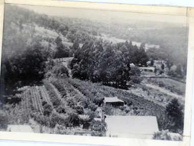
Photograph, 1913 View Over Logan's House in Village Settlement, 1913
Photograph taken in 1913 from Barbers Road showing the view down the valley. Roof in foreground is house on Bob Logan's Lot 28 in the Village Settlement. This photograph has a detailed inscription on the back handwritten by John Lundy-Clarke in 1974.1913 view over Logan’s house on Village Settlement Lot 28 taken from Barber’s Road. This is the house that the runaway log leaped over in 1930 to land far down the orchard row beyond the house. “Shiloah” is centre partly behind the clump of trees and the paddocks of Child and Richardsons pioneer selections are in the background. Link Road is centre right.logan, bob logan, robert logan, barbers road, shiloah, child, richardson, link road -
 Marysville & District Historical Society
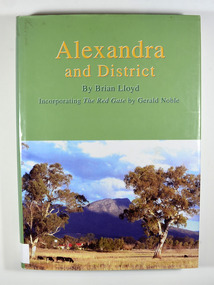
Book, Alexandra and District, 2006
A history of Alexandra and surroundsHardback. Front cover has a photograph of a farmhouse in a paddock with Cathedral Mountain in the background. Back cover has a circular emblem that has a miner digging, a pump house and poppet head and some bales of wool. The words 'Founded on gold wool and butter' surround the centre. There is also a photograph of the main street of old Alexandra with a stagecoach drawn by two horses that has three people seated in and on the stagecoach along with some luggage on the roof.Stamp of the Marysville & District Historical Society Inc / P.O. Box 22 / Marysville 3779alexandra region-victoria, history -
 Southern Sherbrooke Historical Society Inc.
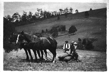
Photograph - Bringing in potatoes at Glen Park Farm, Selby, c.1913
B&W photo shows a two-horse team harnessed to a small sled which is laden with bagged-up potatoes. A man wearing dark hat, waistcoat and trousers and a pale shirt is holding the reins of the horses, and two people who could be the Johns children, Percy and Cissie, are seated on the potatoes. The paddock slopes away and another hillside rises in the background. This is most likely Black Hill. dated c.1913. -
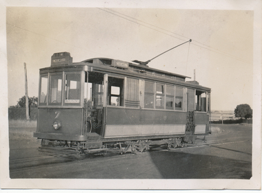 Ballarat Tramway Museum
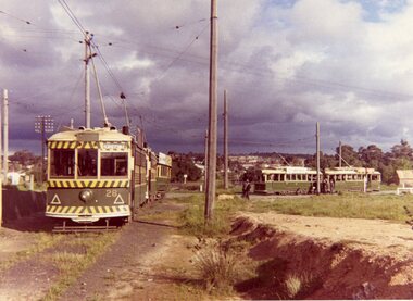
Photograph - Black & White Photograph/s, Wal Jack, 3/03/1940 12:00:00 AM
Black and White print contained within the Wal Jack Bendigo and Geelong Album, see Reg Item 5003 for more details. Photo of Geelong No. 7 at the East terminus. The tram has the destination of Chilwell. In the background are paddocks. Photo by Wal Jack 3/3/1940. Printed on Kodak paper. i1 - scan of print in the album i2 - rear of image i3 - scan of negative at 3200dpi added 6/6/2020. On rear in ink "T140 Geelong Tramways No. 7 Brush Saloon, East terminus 3-3-40. W Jack photo"trams, tramways, geelong, east, tram 7 -
 Kiewa Valley Historical Society
Photos: Bogong Hotel and Kiewa Valley
The Bogong Hotel was a central point for social gatherings in the Kiewa Valley. It was 125 years old when it was burnt down in December 2011. See KVHS 0965See KVHS 0965Black and white photos framed with thick brown cardboard that is framed by two rows of lines around the photo thus forming a frame. The cardboard is folded in half to form a 'card' enabling the photo to stand. 1. People standing outside the Bogong Pub. The pub is behind trees. Two old/vintage cars are partially in the photo. 2.The Kiewa Valley showing paddocks, trees lining the Kiewa River and mountains in the background.bogong pub, kiewa valley -
 Kew Historical Society Inc
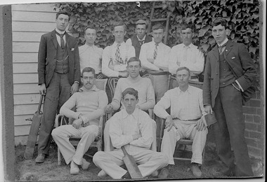
Photograph, First XI, Kew Cricket Club, 1913
The first cricket club in Kew in was formed in 1863, and played its matches in Wellington Street, and then later in O’Shaughnessy’s Paddock. In the early 1870s, a second club was formed and played at Victoria Park. The Kew Cricket Club gained its permanent name in 1888-89. One of the named players in the photograph - Albert Watson - was the son of the local Methodist Minister. The photograph entered the collection within a donation of items by Mrs Joy Ivory, a descendant of the Watson family, and a member of the Society.The photograph, dating from 1911 has local significance as an image of participation in sport and recreation.A monochrome photograph, mounted on card of the Kew Cricket Club's first XI cricket team in 1911. Annotations on the reverse identify three of the players: Standing left with bat: George Twycross; standing right: Albert Clements; Seated third on right: Albert Watson.Presented to Kew Historical by Mrs Ivory (nee Watson) Kew Cricket Club / Standing left with the bat Mr George Twycross / Standing right Mr Bert Clements / Seated third on right Mr Albert Watson / Year 1913kew cricket club (vic), sport - kew - victoria, albert watson, albert clements, george twycross -
 Bacchus Marsh & District Historical Society
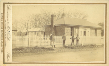
Photograph, Police Barracks Main Street Bacchus Marsh 1883
The Bacchus Marsh Police Barracks shown in this image were located in Main Street on the site of the present day Police Station. The Barracks were constructed around 1857 or 1858. Prior to this the Police were stationed in the Police Paddocks at Maddingley in the area where Maddingley Park is now located. This building was in use by the Police until 1930 when it was replaced by a new building. This later building was in use until the early 2000s but was demolished in 2003 and replaced by a larger Police building.Small sepia unframed photograph on card with gold border framing photograph. Housed in the album, 'Photographs of Bacchus Marsh and District in 1883 by Stevenson and McNicoll'. The image shows the Bacchus Marsh Police Police Barracks and stables in 1883. Two uniformed male police officers wearing helmets can be seen standing on the footpath in front of the building. Next to them on their left stand two boys, one holding a document, possibly a newspaper.. The Barracks is a sandstone building with a chimney on one side; it appears to have a slate roof. Two buildings can be seen behind the main building. A white picket fence with a double gate runs along the front of the complex.On the front: Stevenson & McNicoll. Photo. 108 Elizabeth St. Melbourne. COPIES CAN BE OBTAINED AT ANY TIME. On the back: LIGHT & TRUTH inscribed on a banner surmounted by a representation of the rising sun. Copies of this Portrait can be had at any time by sending the Name and Post Office Money Order or Stamps for the amount of order to STEVENSON & McNICOLL LATE BENSON & STEVENSON, Photographers. 108 Elizabeth Street, MELBOURNE. stevenson and mcnicoll 1883 photographs of bacchus marsh and district, bacchus marsh police station, police stations, police -
 University of Melbourne, Burnley Campus Archives
Plan, Royal Horticultural Society's Garden
Changed boundaries of the site burnley gardens, survey paddock, flood, lynch design, richmond park, yarra river -
 University of Melbourne, Burnley Campus Archives
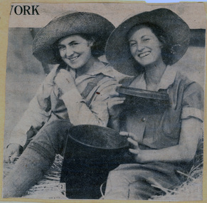
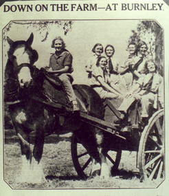
Newspaper - Newspaper Cutting, Down on the farm - at Burnley, 1931
(1) Two students sitting on straw and holding a bucket. (2) Seven female students with a horse and cart. One student is sitting on the horse and the caption reads: "New recruits at Burnley Horticultural School drove in rustic state to gather the maize crop yesterday. So popular has the school course become that there are no more vacancies for students this season. These beginners tackled a tall job, for the maize produced in the school paddock is 10 to 11 feet high."students, female students, burnley horticultural college, maize, students working outside, horses, draught horses -
 Orbost & District Historical Society
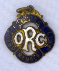
badge, 1890's
This is a member's badge for the Orbost Racing Club and belonged to Mat Lynch. Secretary was Mr W. A. Malcolm. Some of the earliest horse races were held on a course in a paddock belonging to Mr James Cowell at Jarrahmond. For a long time horse races were part of the Marlo Picnic Races. Bellagoogan on Majors Creek near Orbost was the site of the first race course. Mat Lynch was a prominent local identity and generously donated a block of land situated on the Princes Highway, for the Brodribb Hall.Horse racing played a vital role in the history of Orbost. This item is connected to that role.A small metal badge which is a diamond shape with rounded corners. It has a small metal loop at the top. In gold print is "Member Orbost Racing Club" on a dark blue enamel around the edge. In the centre is "ORC" in white enamel.On back - 28 - LYNCH - almost indecipherable.orbost-racing-club lynch-mat recreation horse-racing -
 Orbost & District Historical Society
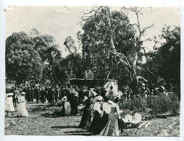
black and white photograph, C1890
This photo shows people at the running of the Orbost Cup in 1890s. The Orbost Race Club was founded in 1890. Many early members were: George Morgan, James Cowell, J. Farquhar, J. Cameron, L. Herbert, S. J. Lynn, Arch. Rodwell, J. Ashby, A. W. McLeod, W. Middleton, W. Archer, J. Pleydell and J. Drew. The races were conducted on a course laid out in a paddock of Mr James Cowell at Jarrahmond. (info. from Newsletter HISTORY OF ORBOST) This item is associated with horse racing in early Orbost.A black / white photograph of a large group of men, women and children at an outing in a bush setting with a large flat area. They appear to be watching an event. Many of the women are holding opened large umbrellas. It is on a grey buff card.horse-racing-orbost orbost-race-club -
 Whitehorse Historical Society Inc.
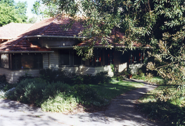
Photograph, 443 Mitcham Road, Mitcham, 1998
Eric Roger Webb moved to Mitcham with his family in about 1932. They lived at 443 Mitcham Road and owned all the land up to Simpson Street. The land was a grass paddock and he planted native trees and shrubs around the perimeter. The Webbs has three children: Eric, Dean and Donald. Mr Webb worked in the public service. He was a councillor of the Shire of Blackburn and Mitcham and later of the city of Nunawading between 1940 and 1949. He was also a Shire President from 1943-1944.Coloured photograph of a house at 443 Mitcham Road, Mitcham. Tiled roof, verandah, path leading to front door.443 mitcham road, mitcham, houses, webb, eric -
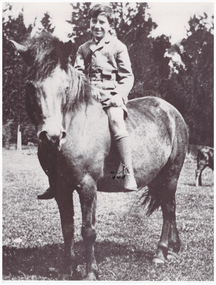 Linton and District Historical Society Inc
Photograph, Gordon Clarke on his Birthday Pony
Gordon Clarke (1906-1996) was the grandson of David Clarke who bought Piggoreet West in 1855. His parents were John Clarke and Mary Jane Newcomen. Gordon Clarke purchased land between Piggoreet and Linton, known as the 'Bird Paddock', and began to intensively plant indigenous species, with a view to providing habitat for native birds. This land was afterwards expanded and is now known as the Clarkesdale Bird Sanctuary. In the 1970s, Gordon donated the sanctuary to the Bird Observers Club of Australia.Black and white copy of original photograph a boy sitting bareback on a horse with no bridle.horses, gordon clarke -
 Eltham District Historical Society Inc
Photograph - Photograph postcard, A peep at the picnickers, Eltham, c.1904
Postcards scanned from the collection of Michael Aitken on loan to EDHS, 13 Feb 2018 Reproduced ‘Pioneers & Painters’ pp 52-53. Picnickers enjoying a Sunday outing in the fields opposite Eltham Railway Station. Looking north towards Research along Main Road near the intersection with Dudley Street. Luther Hayley’s Bakery and General Store on left promoting refreshments and summer drinks. With the opening of the railway to Eltham in 1902, Melbourne residents would regularly enjoy a Sunday excursion journey on the train to Eltham for a day’s outing to the countryside. Possibly the annual State schools picnic held by the Board of Advice at Haley's Paddock near Eltham railway station on 11 March, 1904. Haley’s Paddock (now occupied by Eltham shopping centre) was capable of accommodating 10,000 people, with ample shade and hilly surroundings, an ideal place for any gathering. The main foreground is the site of the present day Eltham Village and Coles Shopping Centre. 1904 'STATE SCHOOLS' PICNIC.', Record (Emerald Hill, Vic. : 1881 - 1954), 19 March, p. 3. http://nla.gov.au/nla.news-article165173087Digital file only Postcards scanned from the collection of Michael Aitken on loan to EDHS, 13 Feb 2018michael aitken collection, postcards, eltham, main road, bakery, eltham village reserve, general store, haley's paddock, luther haley, luther haley general store, picnic, pioneers and painters, railway store, shire of eltham pioneers photograph collection, summer drinks -
 Southern Sherbrooke Historical Society Inc.
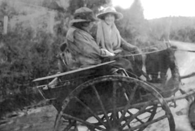
Photograph - Photo, Norah Douglas
Black and White photograph of Mrs Norah Douglas (1864-1957) and an unidentified woman seated on a trap on a road winding between hills. Forest and paddocks are visible. Both women are wearing winter coats and hats with brims. One woman is facing away from the camera. The other woman is facing the camera and is smiling either at the photographer or her companion. The second woman has a heavy scarf or shawl around her neck. See VSSH0046 for further information on the family. -
 Southern Sherbrooke Historical Society Inc.
Photograph - Tantallon, Douglas farm at Menzies Creek/Emerald
Black and White photograph of 'Tantallon', the Menzies Creek/Emerald Farm owned by Norah and Percy Douglas, situated on the north side of Ridge Road. The photo shows a corner of a post and rail fence enclosing a small farm paddock. Behind a row of trees, a brick chimney and part of a roof can be seen, presumably the main farmhouse. Timbered hills can be seen in the background. The photo appears to be taken looking north. See also VSSH0046 for more details. -
 Southern Sherbrooke Historical Society Inc.
Photograph - Glen Park Farm, Selby
B&W photo showing Glen Park Farm, Selby, owned by the Johns family, as seen from the north-east corner. Photo shows the descent to the valley then up Black Hill in the background. Mostly cleared paddock apart from the cypress avenue to the farmhouse (which is glimpsed between the trees) a few single trees dotted about, and the heavily treed area on the top of Black Hill. There is a small building or shed or possibly a haystack in the centre of the photo. -
 Ballarat Tramway Museum
Photograph - Colour Photograph/s, B. Groves?, 7/12/1962 12:00:00 AM
Colour print of five SECV Bendigo trams at the North Bendigo tram terminus during a 1962 tour. Tram 28 (Birney), another Birney and then three single truckers at the terminus. All have their poles turned to return to the City. Photo shows the nature of the location of the terminus; open paddocks. All trams have been fitted with dash canopy lights. Taken on AGFA paper. On rear is a stamped date "- 7.12.62", looks like a machine imprint.On rear "Tram Tour Bendigo / Mr. B. Groves / 333 Pascoe Vale Road / Essendon W5 / Vict." In top right hand corner is the number "1175" In the stamp appears " 110B / Photo / The? / -7.12.62"birney, bendigo, north bendigo, tram 28 -
 Bendigo Historical Society Inc.
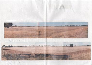
Photograph - Kangaroo Flat Gold Mine Collection: photos of Woodvale site, Daly property, pre dam construction, 1986
Photographs taken at the time of the purchase by Western Mining Corporation of the property owned by G.P. Daly of Raywood Road, Woodvale, in 1986. The intent of the purchase was to provide land for the Woodvale ponds. Land size was 16 acres, known as Allotment 13, Section 3, Parish of Nerring. Paper with two colour photographs attached, each of three photos joined to show landscape view, of the property purchased from G.P Daly by Western Mining Corporation. Photographs show rural land, grassy paddocks with tree line in background. Barb wire fence visible in foreground of bottom photo. Top photograph is titled 23. Daly property looking south-east. Bottom photograph is titled 24. Daly property looking north east. woodvale, g.p. daly, western mining corporation, purchase -
 Eltham District Historical Society Inc
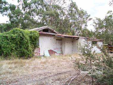
Photograph, Richard Pinn, Wattle Glen Picnic Ground, Dilapidated Pavilion Building, 2015, 07/02/2015
The Wattle Glen Picnic Ground was located in a paddock just west of the Wattle Glen railway station (between the station and the creek). It has now completely disappeared except for a dilapidated overgrown building on a rise across the track from the railway platform. This was the picnic ground's main pavilion, which for a short time (circa 1972-1974) also served as the Wattle Glen post office and general store. The picnic ground operated from circa 1925 until late 1974, its heyday being in the early 1970s.Born digital (three images)wattle glen, picnic ground -
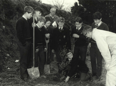 Federation University Historical Collection
Photograph - Photograph - Black and White, Ballarat Technical School Students Plant Out Old Gaol Terraces, 1969, 14/07/1969
When Ballarat Junior Technical School's new building was opened in 1921, the surrounding area was rubble-strewn with raw clay slopes. The Head, A W Steane designed the landscaping of the slopes from the Gaol wall down to the Battery Paddock. The boys did much of the work. Apart from beautifying the grounds, this project occupied their leisure time, particularly as they had nowhere to play. The school acquired the gaol site in April 1969. The work of improving the grounds which was begun by A W Steane and his students is being carried on.Eight Form 1 boys from Ballarat Technical School planting trees at the old Ballarat Gaol terraces. Don Ogilvie is in the foreground. Peter Murley is planting watched by Frank McKenzie in the background. Boys from left: John Brown, Bradley Julius, Gary Green, Steven Ryan, Kim Hall, Peter Gross, Peter Rasmussen.Details of photograph written in pencil on back "Ballarat Courier Press Photograph - Copyright - " stamped on back.ballarat junior technical school, grant street garden, garden terrace, ballarat gaol, battery paddock, former ballarat gaol walls, don ogilvie, john brown, bradley julius, gary green, steven ryan, kim hall, peter gross, peter rasmussen., peter murley, frank mckenzie, ballarat technical school -
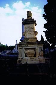 St Kilda Historical Society
Photograph
The Melbourne General Cemetery opened in June 1853. The first male buried there was John Alexander Burnett, chief clerk to the mercantile firm of Dalgety, Borradale & Co. The headstone reads: In Memory of James Alexander Burnett, Merchant, Who Died 25 May 1853, Aged 36 Years. Burnett Street, St Kilda, is named after him. The street was created by F. G. Dalgety when he sold his land in St Kilda (12 acres known as 'Dalgety's Paddock') on 12 April 1853.Colour photographIst Grave in Melbourne Cemetery of St Kilda identity John Alexander Burnettst kilda, john alexander burnett, melbourne cemetery -
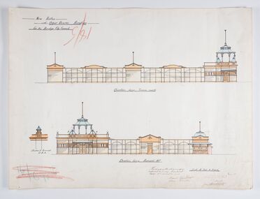 City of Greater Bendigo - Civic Collection
Work on paper - Architectural Drawing, City of Bendigo, New Baths at Upper Reserve Bendigo for the Bendigo City Council, 18th November 1912
The 'New' City of Bendigo baths also known as 'The Baths' were opened on 26th February,1913 at a cost of £2000. These baths made use of an existing dam and had men only and ladies bathing areas as well as a 'paddling paddock' for young children. This set of plans is for the Men's Bathing shed which serviced the men's bathing area adjacent to the still existing tennis courts on Barnard Street. In 1958 the Municipal Baths were replaced by an Olympic Pool and £17,000 was raised by public subscription towards this pool’s construction. Ink, pen, pencil and watercolour architectural drawing for the proposed new baths at the Upper Reserve on Barnard Street, Bendigo.New baths / at Upper Reserve Bendigo / for the Bendigo City Council / Elevation facing tennis courts / Elevation of Terminals at A, A, / Elevation facing Barnard Street / This is one of the drawings /referred to in my contract/ dated 18th November 1912 / Signed Robert J Rogers / (unknown) / Mayor Jas Semmensbendigo swimming club, rosalind park, upper reserve bendigo, faith leech memorial swimming pool, bendigo baths, city of greater bendigo community groups -
City of Kingston
Photograph - Black and white, 27 February 1964
Cheltenham is a suburb in the City of Kingston that was originally established as a rural market gardening community. The area is bordered by Highett. The previous market gardens, farms and paddocks have gradually been sub-divided into housing and industrial estates. The Methodist Children's Home Methodist Homes for Children and St John of God Training Centre on the site of the future Southland shopping centre has not yet been demolished. The recently built Cheltenham High School is visible and the increased urbansation of the area is evident. Some farmland remains including the Le Page homestead.The developing urban area of Cheltenham within the City of Kingston. This image illustrates the mid-century urban sprawl of of Cheltenham and the subdivision of market gardens within the municipality and the changing demographic of the district as new houses are constructed and infrastructure established.Aerial photograph of the suburbs of Cheltenham and Highett within the City of Kingston. Highett Gas Works (top left); Bernard Street, Cheltenham (top right); Weatherall Road (bottom left): Elliott and Cobham Streets Cheltenham (bottom right).White handwritten: X Vic.1831 White type: MELBOURNE 1963 PROJECT RUN23 [underlined] 27-2-64 LENS 205 152-70 M/M 5.150 [arrow] White handwritten: X 166 cheltenham, highett, urbanisation -
 The Beechworth Burke Museum
Photograph - Carte de Visite, William E Barnes
In July of 1880, Ann Jones' successful hotel in Glenrowan burnt to the ground during the Kelly siege. She had opened her business in the year prior having been unsuccessful in her attempt to run a tea-room business in Wangaratta. The first building on this particular site was the home Ann Jones had built for herself and her family. Two years later she converted the home and added the hotel to the rear of the structure. One year later it was burnt to the ground. This image depicts the streetscape of Glenrowan in 1883, three years after the siege. Importantly, it reveals the appearance of several buildings which can reveal information for how Glenrowan (as a small town) might have stood during the siege. These buildings are of typical Australian colonial "miner's cottage" style. On what would have been the site of Ann Jones' hotel, to the far left of the photograph, a police station stands. This police station was built before April 1883. This Carte-de-viste (CdV) taken by renowned Wangaratta based photographer William Edward Barnes previously belonged to the donor's grandfather, Daniel Mullins who was a Police Officer stationed at Glenrowan soon after the Kelly gang siege. Today, the siege has become an important part of Australian culture and Ned Kelly and the Kelly Gang (comprising of Ned Kelly, Dan Kelly, Steve Hart and Joe Byrne) has become ingrained in Australian history and mythology. A CdV is a sepia toned photograph mounted on card and is generally of a small size. This particular style was first patented by Andre Adolphe Eugene Disdéri (1819-1889) in 1854. In 1857, the CdV was introduced to England and after photographs of Queen Victoria, Prince Albert and their family were taken using CdV in 1860 the popularity of this method reached a peak.This photograph is part of the Burke Museum "Kelly album" which includes a significant collection of photographs and artefacts connected to Ned Kelly and the Kelly Gang. Ned Kelly and his gang have become ingrained in Australian popular culture and thus many museums, art galleries and private collections house material connected to the Kelly story which allows the events and people to be researched and interpreted. Artefacts and photographs pertaining to the Kelly gang are particularly valuable for Australian museums. This particular photograph is significant for its connection to Wangaratta based photographer William Edward Barnes and to the Glenrowan Siege and Ann Jones' Hotel which burnt down during the siege in June 1880. Taken in 1883, this photograph has the opportunity to provide information about the townscape of Glenrowan shortly after the siege. It also provides important insight into the architecture and layout of the town. To the far right of the image, the photograph depicts the police station which was built on the site of Ann Jones' Hotel which can provide important information for the Kelly story and how the town evolved following 1880. It is also interesting to emphasise that the police station was built on the site of Ned Kelly and the Kelly gang's last stand.This photograph is a sepia image mounted on yellow card which depicts the newly built police station (in 1882) which stands on the far right of the image on the site of the former Ann Jones Hotel. A fence appears through the lower front of the image and an open paddock is to the left. In the rear centre of the image, there is a mountain. In front of the mountain are many trees, most of them gum. The police station is a one storey structure with a veranda and there are three doorways visible in the image. The image depicts four windows on the front of the station.W.E.Barnes / photographer / Wangaratta / ...1882 / BMM8087kelly album, william barnes, wangaratta photographer, carte-de-viste, glenrowan, 1882, police station, ann jones inn, ann jones hotel, kelly siege, glenrowan siege, colonial australia -
Tatura Irrigation & Wartime Camps Museum
Certificate of Title, Subdivisions, 1879 and 1930
Title Deeds for property in Tatura2 certificates of title showing subdivisions made over several years. Vol. 5655:Folio 1130935 dated 16/5/1930 and Vol.1182: Folio 236330 dated 23/12/1869. Lease between Thomas Hogan and W F Bazeley dated 7th July 1911 for land in Hogan Street known as Slaughter Yard Paddock .Also lease dated 1911. In buff coloured legal envelope with number "2678" and "Hogan - Thomas" written in red on outside.tatura, relationship folders, certificate of title, lease, thomas hogan, john hogan, john james hanlon, edward glover, arthur burke, james brady, andrew collie, jean hunter, sydney embling, john maher, arthur goyen, patrick o'toole, philipe dove, george wildon, edwin harden, cuthbert corke, lee chung, hugh barnes, george manning, francis williams, john fawkner, michael walshe, alexander ferguson, rose gullett, john gibb, william taylor, richard casey, anthony grover, arthur grover, charles brady, elizabeth davey, frank williams, honora culkin, alexander park, stephen reville, richard carr, charles grover, henry mccarthy, james bruce, edward hanley, chew yen, ah poy, loo way, ah dick, charles mitchell, lionel martin, douglas forsyth, catherine wilson, mabel heath, patrick mcnamara, micheal cussen, james wilson, bazeley, documents, legal -
 University of Melbourne, Burnley Campus Archives
Photograph - Colour print, A.P. Winzenried, Down on the Farm-at Burnley, 1931-1990
Photograph made by A.P. Winzenried for, "Green Grows Our Garden," p73Colour photograph. Copy of newspaper article, made by A.P. Winzenried. Caption reads, "Down on the Farm-at Burnley. New recruits at Burnley Horticultural School drove in rustic state to gather the maize crop yesterday. So popular has the school course become that there are no more vacancies for students this season. These beginners tackled a tall job, for the maize produced in the school paddock is 10 to 11 feet high." Horse drawn cart with 6 female students seated on it and one astride the horse.a.p. winzenried, green grows our gardern, maize crop, students, students working outside, west orchard, horse-drawn cart, draught horse -
 Surrey Hills Historical Society Collection
Photograph, Grovedale Road Quarry in the 1920s - looking north, c1920
The quarry was part of John Butler Maling's property. He was one of the original settlers of the area and farmed the area between Weybridge Street and Whitehorse Road. Clay was quarried from part of this area and used to make the bricks used in the construction of his home, known as 'Ancyra'. This is still extant at the corner of Weybridge and James Streets. Maling grazed cows and used the quarry as a water source. He was the uncle of John Butler Maling, Mayor of Camberwell. He was married to Kate Conlon in 1882. They had 3 children: Silas Young, Alick and Zillah. Maling was born in c1829 in Shepreth, Cambridgeshire; he died in Surrey Hills on 9 October 1912 and is buried in Box Hill Cemetery - CE-*-0586. Mrs Kate Maling (born c1859 in Co Meath, Ireland) died at the property on 8 March 1921. She is buried in Brighton General Cemetery. Probate was valued at over 10,000 pounds and included other properties in Sandringham, Hawthorn and Macedon. At the time of her death the Surrey Hills property was described as being 23 cres with 2 brick houses, 1 cow, 2 heifers and 40 fowls or chickens. The property was subdivided after her death. The quarry was filled in after several drownings or near drownings and the land is now occupied by a park and playground maintained by the City of Boroondara. Beckett Park is sited on horizon to the left beyond the trees. This documents the landscape prior to close settlement and is material to early building and farming in the Surrey Hills area.Black and white photo of the quarry between Grovedale Road and James Street taken in the 1920s and looking north. In the foreground is an area of water with high banks dividing the horizontal centre. Beyond are paddocks and trees behind which is a row of at least 3 single-storey houses. Light poles can be seen along a distant street. There are many mature trees in the background. The houses and trees are positioned along Whitehorse Road in the vicinity of Westminster Street. Shadows indicate the photo was taken in early morning or evening.quarries, grovedale road, james street, surrey hills, balwyn, clay quarries, ancyra, kate conlon, kate maling, john butler maling, farming -
 University of Melbourne, Burnley Campus Archives
Album - 35mm Colour slides, Garden Views and Miscellaneous, 1960-1964
18 slides 1960-1964. 1. "Pep Talk" Feb 1960 (Wilson's Promontory?) 2. "Undeveloped land (mowed) Ryde S of H 17.3.61". 3. "Burnley Hort College Feb 1962". 4. "BHC Vege Ground 1963", 5. "Cow Paddock New Plantings. 4, 6, 15, 16, 19. Orchard 1963". 3, 7-11, 13, 14. Garden views Sep 63. 17, 18. "Second Year Students 1964-Mildura".burnley horticultural college, cow paddock, plantings, garden views, students, bhc, lagoon paddock, vegetable plots, mildura camp, orchard, wilson's promontory