Showing 110530 items
matching roads
-
 Ballarat Tramway Museum
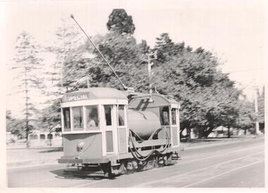
Photograph - Black & White Photograph/s, Geoff Grant, 1954
Yields information about one of the MMTB scrubbers, No. 8, trams after it was repainted to the MMTB work tram colour scheme. This tram is now at the Museum.Black and White photograph of MMTB Scrubber tram No. 8 in Dandenong Road, Caulfield March 1954. Geoff Grant photo. On rear in ink " 8 in Dandenong Road, Caulfield March 1954. G A Grant "trams, tramways, scrubber tram, livery, work trams, dandenong road, tram 8 -
 Eltham District Historical Society Inc
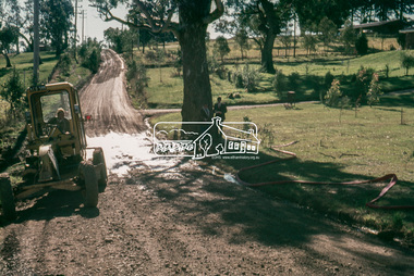
Slide, In Bonds Road looking north at intersection with Montpelier Drive, Lower Plenty, 18 July 1972, 1972
Water drainage work undertaken by Eltham Shire Council in Bonds Road, Lower Plenty outside the Martin property opposite Montpelier Drive, July 1972 Note water flooding across Bonds Road and pile of material removed from the pit on the east side of Bonds Road.35 mm colour positive transparency Mount - Agfacolor Service (Blue)Bonds Road (Martin property) 12.10 pm 18.7.72bonds road, drainage works, eltham shire council, infrastructure, lower plenty, martin property, montpelier drive -
 Kew Historical Society Inc
Document - Urban Planning Document, City of Kew, City of Kew : Minimum Size of Allotment Required, 1945-1955
A document outlining the relevant by-laws produced by the City Of Kew to regulate the minimum size of allotments in Barkers Road, Burke Road, Cotham Road, Glenferrie Road and Studley Park Road, as well as in other streets more generally. The by-laws specify the size of allotments in which single unit dwellings, attached houses and maisonettes, and flats could be built. In the ‘main streets’ a minimum land area for single unit dwellings was 8,100 square feet, with an average frontage of 60’ and a depth of 135’. In other streets this was reduced to an overall size of 6,250 square feet, with an average dimensions of 50’ x 125’. In specifying the land area required by flats, different sizes were regulated for the construction of between two and six flats. Six flats at the time when the regulations were passed must have been the upper limit permitted. Understanding the size of land listed in imperial measurements can be a challenge. Within Australia, the so-called quarter acre block was approximately 11,000 square feet. Those specified in the by-laws would appear to be smaller. The document was pasted on the reverse of a subdivision plan in the collection.This is a rare (undated) document produced by the City of Kew defining how subdivision within the municipality should occur. The document was created to constrain unbridled speculation in subdivisions in the various parts of Kew and East Kew.Undated typed document, issued by the City of Kew (1921-1994) indicating the minimum size of allotment required in Barkers Road, Burke Road, Cotham Road, Glenferrie Road and Studley Park Road. The document is mounted on board and waterstained. It was presumably used by a real estate agent. [Formerly catalogued as MAP.0066].city of kew - by-laws and regulations, subdivisions - kew - studley park -
 Glen Eira Historical Society
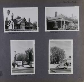
Album - Album page, Glen Eira Road, Circa 1972
This photograph is part of the Caulfield Historical Album 1972. This album was created in approximately 1972 as part of a project by the Caulfield Historical Society to assist in identifying buildings worthy of preservation. The album is related to a Survey the Caulfield Historical Society developed in collaboration with the National Trust of Australia (Victoria) and Caulfield City Council to identify historic buildings within the City of Caulfield that warranted the protection of a National Trust Classification. Principal photographer thought to be Trevor Hart, member of Caulfield Historical Society. Most photographs were taken between 1966-1972 with a small number of photographs being older and from unknown sources. All photographs are black and white except where stated, with 386 photographs over 198 pages. Page 58 of Photograph Album with four photographs of three different properties on Glen Eira Road.Hand written: Glen Eira Road [top right] / 105 Glen Eira Rd 3rd July 1972 [under top left photo] / 245 Glen Eira Road [under top right photo] / 356 Glen Eira Road [under bottom left photo] / 356 Glen Eira Rd [under bottom right photo] / 58 [bottom right] trevor hart, glen eira road, caulfield north, victorian, streetscape, cars, verandahs -
 Chelsea & District Historical Society Inc
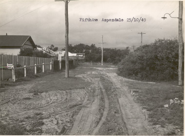
Photograph - Fifth Avenue, Aspendale, 1949
This photo is one of a collection of photos taken during Alan Niemann's - Drainage-Road Making Scheme.Black and white photo of Fifth Avenue, Aspendale. The road is unmade with grass growing on the road, is rutted, houses can be seen on the left and electricity poles are both side of the road. unmade street, aspendale, alan niemann, drainage-road making scheme, edithvale, fifth avenue -
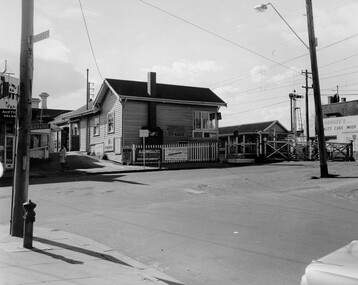 City of Kingston
Photograph - Black and white, c. 1969
Black and white photograph of level crossing gates and railway station at Bentleigh at the intersection of Burgess Street and Centre Road. This image is part of a larger collection of images from the Public Transport Corporation displaying train stations and streetscapes in what is now the City of Kingston.Black and white photograph of level crossing gates and railway station at Bentleigh at the intersection of Burgess Street and Centre Road.Stamped in blue ink on reverse: COPYRIGHT / Public Transport Corporation / For re-ordering photographs / Please quote negative No H3405 / Enquiries C/- PTC Photographic Unit / Telephone switchboard 619 111 White paper adhered to reverse of photograph with black typed text: Railway gates, Centre Road Bentleigh / 1969 / $50 reproduction fee appliesbentleigh, railway station, railway crossing, suburbs, public transport -
 Ringwood and District Historical Society
Photograph, Our Lady of Perpetual Succour - Bedford Road, Ringwood - 1973, 1973
Our Lady of Perpetual Succour in Bedford Road in 1973Typed below photograph, "Our Lady of Perpetual Succour - Bedford Road. 30.9.73" Black and white photograph of brick church with sign outside. -
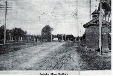 Whitehorse Historical Society Inc.
Photograph, Canterbury Road, Blackburn
Canterbury Road was previously known as Delaney's RoadBlack and white photograph of Canterbury Road, Blackburn before it was sealedcanterbury road, blackburn, roads and streets -
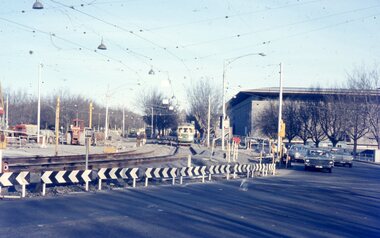 Melbourne Tram Museum
Photograph - Two colour slides - St Kilda Road Trackworks, 1-8-1970
Set of two colour slides showing the intersection of St Kilda Road, City Road and Sturt St. City Road at the start of work to lower City Road under St Kilda Road. The tracks along Sturt St had been diverted by Nolan St (now Southbank Blvd). The photo shows that only one of the tracks had been brought into use, the other still under construction. Photography by Warren Doubleday.Yields information on the start of the works to lower City Road under St Kilda Road 1-8-1970Set of two Anscochrome colour slides, of trackwork to place City Road under St Kilda Road. .1 - SW6 959 on St.-Kilda Rd deviation - shows the Arts Centre and the scale of the deviation. The former tracks into City Road and Sturt St can be seen in the foreground. .2 - SW6 878 - shows the Arts Centre, YMCA building the intersection with City Road and Sturt StHas photographers slide numbers on each slide.st kilda rd, trackworks, city rd, sturt st, sw6 class, tram 959, tram 878, tramways, track -
 Melton City Libraries
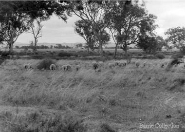
Photograph, Ferris Road Landscape, Unknown
Barrie House on Ferris Road was located on the west side south of Highway. Weather board house was moved from Harkness Rd in 1941 and was moved to Bulmans Road near Porteous Road 1988/90 The site was near the entrance to the Harness Racing Complex.Black and white photos of the Ferris Road landscapeagriculture -
 Eltham District Historical Society Inc
Photograph, Brisbane Street, Eltham (unmade) from west end, 1969, 1969
... roads ...Brisbane Street, Eltham (unmade) from west end, showing light industrial area 1969black and white photograph with white borderverso: Brisbane Street before road made 1967 looking east eltham, 1969, roads, streets, brisbane street, light industrial area -
 Tarnagulla History Archive
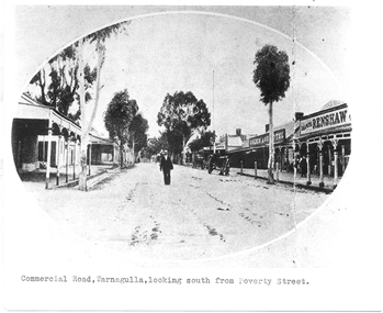
Photograph of Commercial Road, Tarnagulla looking south from Poverty Street, Commercial Road, Tarnagulla Looking South from Poverty Street, January 1907, at the time of the Poseidon Gold Rush, circa 1890 - 1900
Murray Comrie Collection. This is a reasonable copy of an older original. Copy probably made by Murray Comrie in the 1970s. Monochrome photograph. View of Commercial Road Tarnagulla looking south. A man at centre, walking toward camera. Right of this figure are two carts standing at the road's edge. Far right is Renshaw's Drapery and left of that the Golden Age Hotel. A man is walking along the footpath in front of Renshaw's. Typed caption on original is 'Commercial Road, Tarnagulla, looking south from Poverty Street'.tarnagulla, commerce, stores, shopping, shops, draper, hotels, golden age hotel, buildings, commercial road, main street -
 Glenelg Shire Council Cultural Collection
Photograph - Photograph - Blacknose Quarry, 29/09/1952
Port of Portland Authority ArchivesFront: 'BLACKNOSE QUARRY ACCESS ROAD 25.9.52 LOOKING SOUTH ' - printed on bottom frame Back: Purple PHT stampport of portland archives, blacknose quarry -
 City of Moorabbin Historical Society (Operating the Box Cottage Museum)
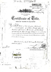
Document - Photocopy of Land Title 1881, c1881
This is a Certificate of Title for an acre of land in 'Tucker's Road' purchased by Jabez Gurr in 1881, in the area that was part of the Crown Block known as Henry Dendy's Special Survey 1841, in the Parish of Moorabbin, County of Bourke, Victoria. Following the 'Transfer of Land Statute' allotments in the area of Henry Dendy's Special Survey of 1841 were sold to early settlers. This Certificate of Title shows the passage of history in Moorabbin Shire . Jabez Gurr, a wheelwright, of East Brighton, now Bentleigh East, purchased an acre of land in 'Tucker's Road' , near Centre Road, in 1881. In 1889 he sold to a produce merchant, Robert Smith, and in April 1916 this block was purchased by William Henry George Box, a market gardener and relative of William and Elizabeth Box, who owned the land until 1926. The land was then purchased by Charles John Greenlaw Coates and remained with this family until 1971. All these Family names appear on Councils and Community Boards during the foundation and development of City of Moorabbin3 photocopied pages of the Certificate of Title for approximately 1 acre of land near the corner of Centre Road and Tucker Road, Parish of Moorabbin, County of Bourke, Victoria that was part of the 5,120 acre Henry Dendy Special Survey in Brighton in 1841 and purchased in 1881 by Jabez Gurr. It records subsequent proprietors up to 1971Stamped CANCELLED 12 OCT 1994 (top Right) / Entered in the Register Book / Vol.1245 Fol. 248877/ signed Henry Crowe / Assistant Registrar of Titles / Coat of Arms / VICTORIA / Certificate of Title / UNDER THE ' TRANSFER OF AND STATUTE' /dated ' eleventh day of April one thousand eight / hundred and eighty one' / signed 'Henry Crowe' / Assistant Registrar of Titles/ ENCUMBRANCES REFERRED TO / circular Stamp 'OFFICE OF TITLES VICTORIA' / Drawn and shaded on the left side is the area of land in "Tucker's" Road 3331/3 links fro Centre Road, 150 links x 6662/3 links / The measurements are in linksdendy henry, dendy's special survey 1841, brighton, moorabbin, bentleigh, market gardeners, early settlers, pioneers, wheelwrights, merchants, fruit gardens, markets, smith robert, box william henry george, gurr jabez, county of bourke, victoria, melbourne, land statutes, tucker road, centre road, box william, box elizabeth, box cottage museum -
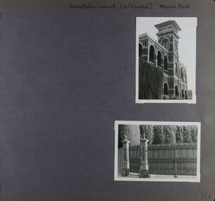 Glen Eira Historical Society
Album - Album page, Presentation Convent (ex "Cambria), Neerim Road, Circa 1972
This photograph is part of the Caulfield Historical Album 1972. This album was created in approximately 1972 as part of a project by the Caulfield Historical Society to assist in identifying buildings worthy of preservation. The album is related to a Survey the Caulfield Historical Society developed in collaboration with the National Trust of Australia (Victoria) and Caulfield City Council to identify historic buildings within the City of Caulfield that warranted the protection of a National Trust Classification. Principal photographer thought to be Trevor Hart, member of Caulfield Historical Society. Most photographs were taken between 1966-1972 with a small number of photographs being older and from unknown sources. All photographs are black and white except where stated, with 386 photographs over 198 pages. References cited above indicate that Cambria was demolished around 1974-1976 (2 dates given). Caulfield's Built Heritage states it was built for Cyril Godby with the National Trust (Victorian Heritage Database) saying it was built in 1888.Page 144 of Photograph Album with two photographs (one portrait, one landscape) of Presentation Convent, Neerim Road.Handwritten: Presentation Convent (ex- "Cambria") Neerim Road [top] / 144 [bottom right]trevor hart, presentation sisters, cambria, presentation convent, roseberry grove, glen huntly, neerim road, convent, victorian, polychrome bricks, mansions, gates, verandahs, balconies, towers, lookouts, cyril godby, house names -
 Hawthorn Historical Society
Drawing - Property Illustration, 1-4/12 Burwood Road, Hawthorn
'After training as a Cartographic Draftsman within the mining industry, I worked as a property illustrator for real estate firms in the eastern suburbs of Melbourne for 23 years from 1983. I initially photographed houses with a Polaroid camera and made a 'thumbnail' sketch while there. The photos were used to scale off a sketch in pencil and then that sketch was overlaid with drafting film and the 'pen and ink' completed. The pens I used were the Rotring ‘Rapidigraph’ drafting pens. The ink was also made by Rotring (German).The film was ‘Rapidraw’, polyester drafting film, double matte. It takes a very fine line and doesn’t bleed. As well as house sketches, there were often floor plans and site plans ordered. Aerial sketches were ordered when the property needed an overall view.' (Margaret Picken, 2020)This property illustration is one of a series created by Margaret Picken for a range of real estate agents in Melbourne between c. 1983 and c. 2006. Each work is signed and dated by the artist.Gift of Margaret Picken, 2020Pen and ink property illustration on drafting film of 1-4/12 Burwood Road, Hawthorn by Margaret Picken.1-4/18 Burwood Road, Hawthorn, Marg Picken '95. Woodards - Haw.artist - margaret picken 1950- -
 Hawthorn Historical Society
Drawing - Property Illustration, 17 & 17A Clifton Road, Hawthorn East
'After training as a Cartographic Draftsman within the mining industry, I worked as a property illustrator for real estate firms in the eastern suburbs of Melbourne for 23 years from 1983. I initially photographed houses with a Polaroid camera and made a 'thumbnail' sketch while there. The photos were used to scale off a sketch in pencil and then that sketch was overlaid with drafting film and the 'pen and ink' completed. The pens I used were the Rotring ‘Rapidigraph’ drafting pens. The ink was also made by Rotring (German).The film was ‘Rapidraw’, polyester drafting film, double matte. It takes a very fine line and doesn’t bleed. As well as house sketches, there were often floor plans and site plans ordered. Aerial sketches were ordered when the property needed an overall view.' (Margaret Picken, 2020)This property illustration is one of a series created by Margaret Picken for a range of real estate agents in Melbourne between c. 1983 and c. 2006. Each work is signed and dated by the artist.Gift of Margaret Picken, 2020Pen and ink property illustration on drafting film of 17 & 17A Clifton Road, Hawthorn East by Margaret Picken.17 & 17A Clifton Road, Haw E, Margaret Picken '92. Woodards - C'well.artist - margaret picken 1950- -
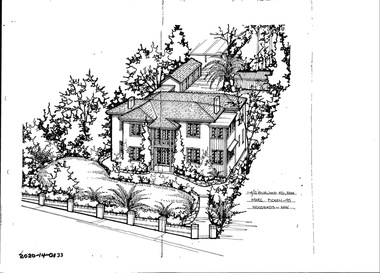
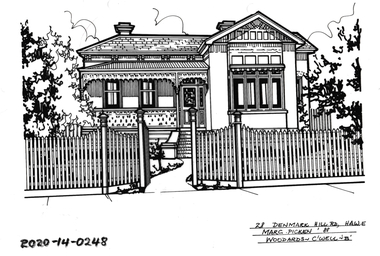
 Hawthorn Historical Society
Drawing - Property Illustration, 2/ 10 Denmark Hill Road, Hawthorn
'After training as a Cartographic Draftsman within the mining industry, I worked as a property illustrator for real estate firms in the eastern suburbs of Melbourne for 23 years from 1983. I initially photographed houses with a Polaroid camera and made a 'thumbnail' sketch while there. The photos were used to scale off a sketch in pencil and then that sketch was overlaid with drafting film and the 'pen and ink' completed. The pens I used were the Rotring ‘Rapidigraph’ drafting pens. The ink was also made by Rotring (German).The film was ‘Rapidraw’, polyester drafting film, double matte. It takes a very fine line and doesn’t bleed. As well as house sketches, there were often floor plans and site plans ordered. Aerial sketches were ordered when the property needed an overall view.' (Margaret Picken, 2020)This property illustration is one of a series created by Margaret Picken for a range of real estate agents in Melbourne between c. 1983 and c. 2006. Each work is signed and dated by the artist.Gift of Margaret Picken, 2020Pen and ink property illustration on drafting film of 2/10 Denmark Hill Road, Hawthorn by Margaret Picken.2/10 Denmark Hill Road, Hawthorn, Margaret Picken '91. Woodards - C'well.artist - margaret picken 1950- -
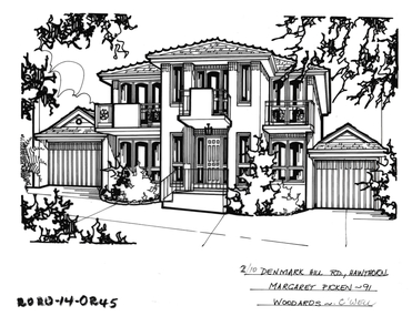
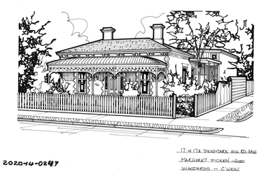 Hawthorn Historical Society
Drawing - Property Illustration, 17 & 17A Denmark Hill Road, Hawthorn
'After training as a Cartographic Draftsman within the mining industry, I worked as a property illustrator for real estate firms in the eastern suburbs of Melbourne for 23 years from 1983. I initially photographed houses with a Polaroid camera and made a 'thumbnail' sketch while there. The photos were used to scale off a sketch in pencil and then that sketch was overlaid with drafting film and the 'pen and ink' completed. The pens I used were the Rotring ‘Rapidigraph’ drafting pens. The ink was also made by Rotring (German).The film was ‘Rapidraw’, polyester drafting film, double matte. It takes a very fine line and doesn’t bleed. As well as house sketches, there were often floor plans and site plans ordered. Aerial sketches were ordered when the property needed an overall view.' (Margaret Picken, 2020)This property illustration is one of a series created by Margaret Picken for a range of real estate agents in Melbourne between c. 1983 and c. 2006. Each work is signed and dated by the artist.Gift of Margaret Picken, 2020Pen and ink property illustration on drafting film of 17 & 17A Denmark Hill Road, Hawthorn by Margaret Picken.17 & 17A Denmark Hill Road, Hawthorn, Margaret Picken 2000. Woodards - C'well.artist - margaret picken 1950- -
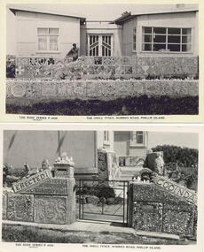 Phillip Island and District Historical Society Inc.
Photograph - Post Card, Rose Series, 1960's
The Shell House fence was erected in 1958 by M. Moloney and A Robertson. House was called Cooinda.Two black & white postcards of The Shell House and Fence, Nobbies Road, Phillip Island. (Now longer standing). The Rose Series P 4026 and 4028. The Shell Fence, Nobbies Road, Phillip Island.the shell house phillip island, the shell fence summerland phillip island, olive blamey -
Whitehorse Historical Society Inc.
Article, Mansion from yesteryear, 2001
Article on 567 Whitehorse Road, Mitcham.Article on 567 Whitehorse Road, Mitcham, 80 year old house of 10 rooms for sale, Agent: K.R. Rose & Co. On verso advertisements for Unit 2, 204 Blackburn Road, Blackburn and 1 Winchester Road, Nunawading.Article on 567 Whitehorse Road, Mitcham. whitehorse road, mitcham, no 567, blackburn road, blackburn, no 204, winchester road, nunawading, no 1 -
 City of Kingston
Pamphlet - Colour, Farrow Falcon Press, Printers, Ozone Estate, Bluff Road, Hampton, c. 1940
Sales plan for land in the suburb of Hampton (Highett), bounded by Bluff Road, Wickham Road, Peterson Street and June Street. Includes Morley Street, Follett Avenue, and Parrett StreetThe developing urban area of Highett within the City of Kingston. This land sale pamphlet illustrates the subdivision of land within the municipality and the changing demographic of the district as new houses are constructed close to infrastructure.Colour pamphlet advertising for private sale the Ozone Estate, Bluff Road Hampton. Incorporates a map of the estate bordered by Bluff Road, Wickham Road, June Street and Peterson Street including Morley Street, Follett Avenue and Parrett Street.Handwritten in grey pencil on rear: Ozone Estateland sales, estate, highett, hampton -
 Whitehorse Historical Society Inc.
Photograph - Strip photo and photocopy, Railway Road Blackburn, 1/08/1976 12:00:00 AM
Railway Road Blackburn. East end.Railway Road Blackburn. East End.blackburn, railway road, shops -
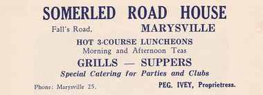 Marysville & District Historical Society
Ephemera (item) - Advertisement, SOMERLED ROAD HOUSE, Unknown
An advertisement for Somerled Road House in Marysville.An advertisement for Somerled Road House in Marysville.marysville, victoria, australia, somerled holiday home, j.c. greatorex, r. greatorex, mrs d. ivey, advertisement -
 Hawthorn Historical Society
Drawing - Property Illustration, 28 Denmark Hill Road, Hawthorn
'After training as a Cartographic Draftsman within the mining industry, I worked as a property illustrator for real estate firms in the eastern suburbs of Melbourne for 23 years from 1983. I initially photographed houses with a Polaroid camera and made a 'thumbnail' sketch while there. The photos were used to scale off a sketch in pencil and then that sketch was overlaid with drafting film and the 'pen and ink' completed. The pens I used were the Rotring ‘Rapidigraph’ drafting pens. The ink was also made by Rotring (German).The film was ‘Rapidraw’, polyester drafting film, double matte. It takes a very fine line and doesn’t bleed. As well as house sketches, there were often floor plans and site plans ordered. Aerial sketches were ordered when the property needed an overall view.' (Margaret Picken, 2020)This property illustration is one of a series created by Margaret Picken for a range of real estate agents in Melbourne between c. 1983 and c. 2006. Each work is signed and dated by the artist.Gift of Margaret Picken, 2020Pen and ink property illustration on drafting film of 28 Denmark Hill Road, Hawthorn by Margaret Picken.28 Denmark Hill Road, Haw E, Marg Picken '88. Woodards - C'well - 'B'.artist - margaret picken 1950- -
 Whitehorse Historical Society Inc.
Photograph - B;ack and white photograph, Old Dam - Corner of Blackburn and Canterbury Road Blackburn, c. 1922
Dam on the corner of Canterbury and Blackburn Roads where the Bellbird Hospital now stands.Black & white photo of S.W. corner of Blackburn Road and Canterbury Road c1922. Mrs wellman is standing on rock.wellman mrs, blackburn road blackburn, canterbury road blackburn -
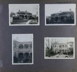 Glen Eira Historical Society
Album - Album page, Seymour Road, Circa 1972
This album was created in approximately 1972 as part of a project by the Caulfield Historical Society to assist in identifying buildings worthy of preservation. The album is related to a Survey the Caulfield Historical Society developed in collaboration with the National Trust of Australia (Victoria) and Caulfield City Council to identify historic buildings within the City of Caulfield that warranted the protection of a National Trust Classification. Principal photographer thought to be Trevor Hart, member of Caulfield Historical Society. Most photographs were taken between 1966-1972 with a small number of photographs being older and from unknown sources. All photographs are black and white except where stated, with 386 photographs over 198 pages. As at 22/08/2021, 51 Seymour Road is included in the HO179 Beemery Park Precinct which C204glen Amendment seeks to add to the Glen Eira Planning Scheme (amongst others). This is not yet finalised. Bellecourt (so named in 1989 according to Andrew Ward's Heritage Study) was originally named Beemery.Victorian Heritage Database HO62 Bellecourt 85 Seymour Road ELSTERNWICK https://vhd.heritagecouncil.vic.gov.au/places/35585 (as of 22/08/2021) "Beemery" at 85 Seymour Road, is an imposing ltalianate villa with arcaded asymmetrical facade built in 1891 for Charles Langdon. It has aesthetic, historical and social significance. Its aesthetic value rests with the facade which is highly representative of a not uncommon villa form of the late Victorian period. Its historical value derives from its association with the Langdon family in Caulfield (compare "Rosecraddock", "Tarqua" and "Hengar"). Its social value derives from its ability to demonstrate a lifestyle in late Victorian Caulfield.Page 190 of Photograph Album with four photographs of two different properties on Seymour Road.Handwritten: Seymour Road [top right] / 51 [under top left photo] / 51 [under top right photo] / 85 [under bottom left photo] / 85 [under bottom right photo] / 190 [bottom right]trevor hart, elsternwick, seymour road, late victorian, caulfield, beemery, bellecourt, house names, langdon family, charles langdon, cast iron work, verandahs, polychromatic brickwork, italianate style, arched balconies -
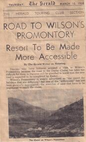 Phillip Island and District Historical Society Inc.
Newspaper clippings, 10/03/1938
Article describing access to Darby Chalet on Wilson's Promontory and the improvement of this with the new road.Article on road to Wilson's Promontory.local history, documents, newspapers, wilson's promontory, darby chalet, black & white newspaper clipping -
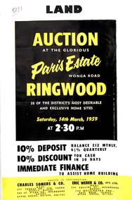 Ringwood and District Historical Society
Flyer, Land Auction Advertisement, Paris Estate, Ringwood, Vic. - 1959
Double sided single page black and yellow printed advertisement for auction of home sites at Paris Estate, Wonga Road, Ringwood, Vic., on Saturday, 14th March, 1959, with terms of sale, locality map, subdivision features and summary of local services.Subdivision includes Mullum Mullum Road, Hendra Grove, Sunhill Road, and Wonga Road. Agents in conjunction: Charles Somers & Co., South Yarra and Melbourne, and Eric Weber & Co., Melbourne and East Melbourne. -
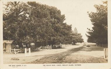 Phillip Island and District Historical Society Inc.
Photograph - Post Card, Early 1900's
One of 17 photographs donated by Olive BlameySepia postcard of the Beach Road with fence and trees on the left and trees on the right."The Rose Series, P. 674" "The Beach Road, Cowes, Phillip Island, Victoria" Letter on back to Lois from Auntie Alicebeach road, cowes phillip island, phillip island, olive blamey