Showing 620 items matching " tower hill"
-
 Surrey Hills Historical Society Collection
Photograph, Faraday & Kent, 172 Union Road, Surrey Hills, 1983
Prior to Faraday and Kent establishing a paint retail business of this site, there was a car hire business called Cobb & Co and prior to this the site was a Golden Fleece Service Station. Paul Towers bought the property from Faraday & Kent, for whom Norm Henderson was the proprietor, in 1996. In 2003 it was bought by Evan Lewis. (NOTE re source: undated note re verbal history given by un-named person).A colour photograph of a two storey building with Faraday & Kent Pty Ltd on the front of the building. A small brick fence has an address on it identifying it as 168-172 Union Road. There are cars parked to the right of the photo and a number of trees.guildford road, surrey hills, faraday & kent, businesses, cars, 1983, paint shop, 1993, cobb & co, 1978, union road, mr norman henderson, car hire, evan lewis, paul towers -
 Surrey Hills Historical Society Collection
Photograph, Faraday & Kent, 172 Union Road Surrey Hills, 1979
This site was previously occupied by a Golden Fleece petrol station and later by Cobb & CO car rental. In Paul Towers bought the property from Faraday & Kent, for whom Norm Henderson was the proprietor, in 1996. In 2003 it was bought by Evan Lewis. (NOTE re source: undated note re verbal history given by un-named person).A colour photograph of the corner of Guildford Road and Union Road. There are four cars parked in front of a building. There is a sign identifying Faraday & Kent - home painting and wallpaper.guildford road, surrey hills, faraday & kent, businesses, paint shop, union road, norman henderson, evan lewis, paul towers, norm henderson -
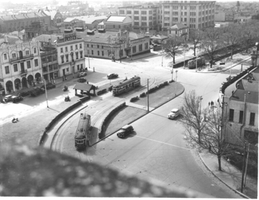
 Melbourne Tram Museum
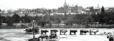
Photograph - Illustration, Panoramic View of Melbourne Southern Aspect
... Aspect" photo from the Eastern Hill Fire Station watch tower..." photo from the Eastern Hill Fire Station watch tower, late 1890s ...Illustration titled - "Panoramic View of Melbourne Southern Aspect" photo from the Eastern Hill Fire Station watch tower, late 1890s early 1900s of a view looking south. There are three maybe four cable trams in the view. The photograph notes the St Patrick's Cathedral (consecrated in 1897), the German Lutheran Church, Government offices, Treasury Buildings, Government House in the far distance, St Peters Church, and the Victorian Parliament building. The photo looks along Gisborne and Macarthur Streets.Yields information about the Eastern Hill and Parliament precinct late 1890's early 1900's.Black and white print of a published illustration - Panoramic View of Melbourne Southern Aspecteastern hill, cable trams, st patrick's cathedral, gisborne street, macarthur street, st peters church -
 Bendigo Historical Society Inc.
Document - SANDHURST BUILDING SOCIETY CENTENARY 1981 CALENDAR
Buff Paper, Sepia Text & Illustrations 7 Pages Views of Sandhurst 1881 Calendar Images: Beehive Chambers and Mining Exchange Hotel, Pall Mall; panorama from Post Office Tower looking north to White Hills; Sandhurst Post Office Pall Mall; Sandhurst Railway Station (opened 1862) and Quarry Hill;Alexandra Fountain, Charing Cross, (opened 1881); panorama from Post Office Tower looking south to Golden Square.bendigo, history, sandhurst building society calendar -
 Ringwood and District Historical Society
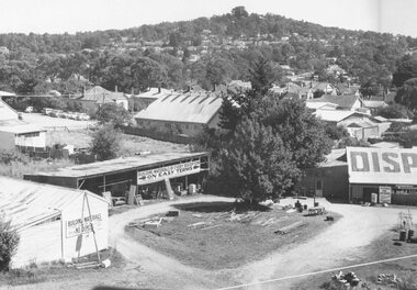
Photograph, Maroondah Highway Central, Ringwood. Corner of Warrandyte Road and Maroondah Highway taken from clock tower. 1960 including Disposal business (formerly Bamford's Timer Yard)
Black and white photograph (2 copies)Written on back of one copy: "Corner of Maroondah Highway and Warrandyte Road. Foreground- formerly Bamford's timber yard,. Centre- Presbyterian Church. Laughnan's Hill in background. -
 Ringwood and District Historical Society
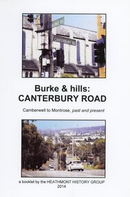
Book, Burke & Hills: Canterbury Road Camberwell to Montrose, by Heathmont History Group - 2014
Soft cover book of 40 pages with spiral wire spine. Compilation of images and descriptive timeline of the geology, geography and European settlement history of Canterbury Road.Soon after beginning at Burke Road Camberwell, Canterbury Road moves into the gentle hills of Canterbury, then on to Surrey Hills, Box Hill and Forest Hill. Further along past these three "hills" come three "monts" - Vermont, Heathmont and at its other end, Montrose, by then in the foothills of the Dandenongs. Grand homes and churches at one end, major and minor shopping centres along the 25km, factories now where farms were, big box stores, fast food outlets, train stations, resrvoir, traffic, residential stretches, modern apartment blocks, parklands, child-minding centres, sporting ovals, a sewage farm, hotels, quarries, commercial developments, plant nurseries, a golf course, bridges, memorials, Asian food shops, telecommunication towers, bushland, creeks, crossroads, traffic lights, mansions, orchards, swamps ... Delaneys Road, renamed Canterbury Road after a 19th century Victorian Governor, is a fascinating study in land use and history as suburban Melbourne has continually diversified and pushed outwards. Compiled by Heathmont History Group, Rita James, Les Prato, Betty Colbert, Jeff Leipold, Gerry Robinson (convenor). -
 Bendigo Historical Society Inc.
Negative - TOM PATULLO COLLECTION: A COUNTRY TOWN
Negative print. Rosalind Park (Camp Reserve), Bendigo looking over Park Road, the Bendigo Creek, Camp Hill State School, with the Bendigo Masonic Hall Left and the Government Camp on the top of the Hill; near where the present day lookout tower stands; to the left of the state school. The Consolidated High School is on the extreme right hand side. The police barracks are between the two schools. The original consolidated school building has been built around and is incorporated into the current Bendigo Senior Secondary School buildings.bendigo, sandhurst, tom patullo collection, bullock wagon, camp reserve bendigo, rosaling park bendigo, camp hill school, bendigo consolidated high school -
 Bendigo Historical Society Inc.
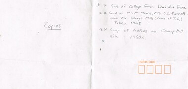
Photograph - LA TROBE UNIVERSITY BENDIGO COLLECTION: BENDIGO TEACHERS' COLLEGE
BHS CollectionA long white envelope which contained four photos relating to Bendigo Teachers' College in the 1940's and 1950's. It has writing in grey lead giving information on each photo. A black and white photograph of the prefabs on the Bendigo Teachers' College Camp Hill site in the 1950's A black and white photo of The Bendigo Teachers' College site taken from the Look Out Tower in the park. Two black and white photographs of three staff members at Bendigo Teachers' College in 1945 - Mr. M. Morris, Ms. J.C. Burnett and Mr. George Mills (Principal). 2 separate photos.bendigo, education, bendigo teachers' college students, la trobe university bendigo collection, collection, bendigo teachers' college, staff, photo, photographs, photograph, person, individual, male, female, bendigo, education, building, envelope -
 Melbourne Tram Museum
Postcard, La Trobe Collection, State Library of Victoria, Cable tram display at Box Hill, c1980
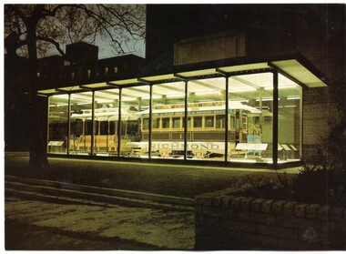
Postcard - black and white reproduction of a wall poster used by the Box Hill - Doncaster Tramway, includes sketch of Doncaster Tower, one of the tram cars and timetable. See Reg Item 699 and 198. Printed for the State Library of Victoria, by John Sands - Number PC11. Divided back, caption, printing information and bar code where a stamp would go. Robert Green advised by email 20-1-2018: "The tram in Russell Street was unveiled by the Premier, R J Hamer, on 1 May 1975. The ceremony was attended by F R Kirby, the Chairman of the M&MTB, and the Chairman (Judge Leckie) and Director (R H Fowler) of the Science Museum of Victoria." The tram was removed from the glass case when further development to the buildings occurred and temporarily relocated to Box Hill for the centenary of the Doncaster Tramway. 2nd copy of postcard - on rear - Has 33 cent stamp, postmarked for the Centenary of Cable Car Services, 11/11/1985 with a grip included and stamped "100 years of Melbourne trams carried on Commemorative official trip from Flinders St, Melbourne to Richmond Town Hall, November 11, 1985" in blue ink in the top left hand corner.trams, tramways, box hill, posters, timetables, doncaster, postcards, cable trams -
 Melbourne Tram Museum
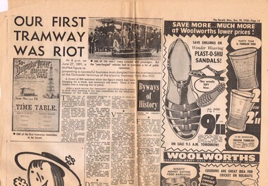
Newspaper, Herald Sun, "Our First Tramway was Riot", Jul. 1955
Newspaper clipping from The Herald, Monday 29 Dec. 1958, page 13 about the re-opening of the Box Hill - Doncaster tramway on 27/6/1891, the story of the tramway, involvement of Mr. Hilton, the Doncaster Tower, disputes with land owners, and its final closure on 6/1/1896. No author given for the article.trams, tramways, box hill, doncaster, tramways -
 Melbourne Tram Museum
Photograph - Block Mounted Photograph, Surrey Hill Neighbourhood Centre, 1926
Photograph - mounted onto a heavy card, numbered 65-575 in the top right hand corner of Whitehorse Road Balwyn, looking east from near corner of Balwyn Road in 1926. Notes that the image is courtesy of the TMSV. See image i2 for the actual photograph. 4673.1 - loose print of the photograph with the words on the rear: "Melbourne / Whitehorse Road, eastwards at Balwyn Road, Balwyn (Building at left with domed tower is on north west corner). Probably early 1930's.On rear in ink "Copied for Keith Kings, Nov. 2002" and the "Surrey Hill Neighbourhood Centre" stamp.trams, tramways, whitehorse road, balwyn -
 Melbourne Tram Museum
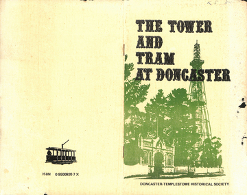
Book, Doncaster - Templestowe Historical Society, "The Tower and Tram at Doncaster", 1980
Book - 2 folded sheets (4 pages) centre stapled within an manila coloured cover, titled "The Tower and Tram at Doncaster", published by the Doncaster - Templestowe Historical Society 1980. Written by Irvine Green and Ken Smith. Gives a brief history of the Tower and Doncaster Tram including a reproduction of the Timetable on the inside of the cover.Has remnants of "K. Stodden" in ink on the top right hand corner of the cover,trams, tramways, doncaster, box hill, tramways -
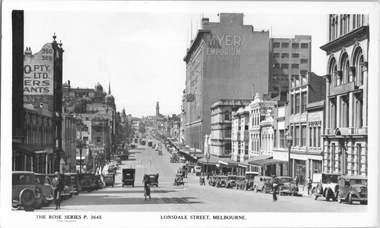 Melbourne Tram Museum
Postcard, Rose Stereograph Co, "Lonsdale Street Melbourne', c1933
... Emporium Lonsdale Street store and the Eastern Hill fire station... Lonsdale Street store and the Eastern Hill fire station tower ...Rose Series postcard No. P 3645, titled "Lonsdale Street Melbourne', looking east from Queen Street. Has several cable trams in the far distance at Swanston Street. In the view is the Myer Emporium Lonsdale Street store and the Eastern Hill fire station tower. There are adverts for Dulux, Tribune, Wynss, Fox films, A E Hoad? Stillwell Stephens. The cable trams in Lonsdale Street west of Elizabeth Street closed in early 1935 and the remainder in 1939. Yields information about Lonsdale St c1933.Postcard - printed real photograph with Rose Stereograph Co. name on the rear.Has the 3rd part of a letter to Ken on the rear.trams, tramways, cable trams, lonsdale st, myer -
 Melbourne Tram Museum
Poster, City of Box Hill, "Box Hill Tramway", 1989
Reproduction of a wall poster used by the Box Hill - Doncaster Tramway, includes sketch of Doncaster Tower, one of the tram cars and timetable. Printed in two colours on heavy cartridge paper. Printed for centenary of tram by the City of Box Hill? Was Australia's first electric tramway. See also reference for further information on the tramway itself.trams, tramways, box hill, posters, timetables, doncaster -
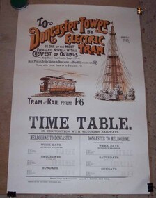
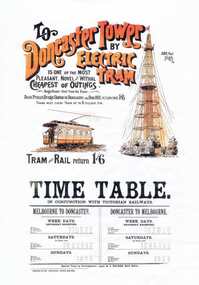 Melbourne Tram Museum
Photograph - Colour Photocopy/photocopies, "To Doncaster Tower by Electric Tram", c1990
Colour photocopy reproduced onto an A3 sheet titled "To Doncaster Tower by Electric Tram" reproduction poster, advertising the Box Hill to Doncaster tramway, featuring an image of the tower, tramcar giving details of the train / tram fare from Princes Bridge Station and the timetable for trains and trams. Has the name of "H. J. Hilton" on the lower edge and printed by "Reporter" office, Box Hill. For the framed poster see Reg Item For a printers version of the poster (black and white) see Reg Item 326.trams, tramways, box hill, doncaster, railways -
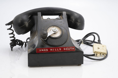 Department of Energy, Environment and Climate Action
Field telephone - Fire Tower
After the 1939 bushfires, the Forests Commission Victoria invested heavily in a radically new communications network. After suffering some inevitable delays due to the war, radio VL3AA switched into full operation in October 1945 proudly beaming out 200 watts across the State. But by today’s standards, the technology was primitive and the reception poor unless the user was on a high point somewhere. The radio signal was "line-of-sight" and bounced between fire towers and relay transmitters across the mountains back to the District offices. The advent of solid-state electronics in the 1960s replaced the more delicate valve sets which enabled greater use of vehicle mounted radios. The Commission continued to research, develop and build new radios at its many workshops around Victoria. The network was supported by a large team of skilled radio technicians. The more secure and versatile State Mobile Radio (SMR) digital trunk system came into operation in about 1995. Upgraded Tait Radios were purchased in 2014 after recommendations of the 2009 Bushfires Royal Commission. But it was the convergence of separate technologies such as 5G mobile phones, high-capacity and light-weight lithium batteries, Wi-Fi, the ever-expanding internet, cloud data storage, digital cameras, GPS, personal organisers and hundreds of supporting Apps into powerful smartphones and tablets which revolutionised bushfire communications from the mid-2000s. Used to communicate to remote fire towers Single wire often run through the bush from FCV district officesFire tower telephone with winderChristmas Hills South Instructions for use around winderbushfire, radios, forests commission victoria (fcv) -
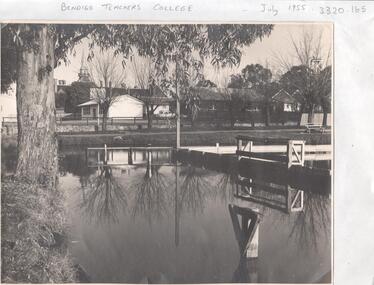 Bendigo Historical Society Inc.
Photograph - LA TROBE UNIVERSITY BENDIGO COLLECTION: BENDIGO TEACHERS' COLLEGE
... photograph photographs site place municipal baths Camp Hill State ...A black and white photograph of Bendigo Teachers' College in July 1955. The photograph was taken by Mr. A.G. Davey or Mr. Tailor. The Municipal Baths are in the foreground and the Lookout Tower can be seen on the right hand side. On the right of the buildings which housed Rooms 3,4,5 and 6 is the brick building Room 2. In the background is the Camp Hill spire. Reflections of the trees and wooden constructions can be seen in the water. A vanguard car is parked in the school car park. See 3320.100bendigo, education, bendigo teachers' college, la trobe university bendigo collection, collection, bendigo, education, tertiary education, teacher training, bendigo teachers' college, photo, photos, photograph, photographs, site, place, municipal baths, camp hill state school, lookout tower, history, miss j.c. burnett, mr. geoff pryor -
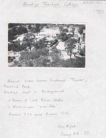 Bendigo Historical Society Inc.
Photograph - LA TROBE UNIVERSITY BENDIGO COLLECTION: BENDIGO TEACHERS' COLLECTION
A black and white photograph of an arial view of Bendigo Teachers' College from the Lookout Tower in Rosalind Park in the 1950's. Room 2 is the old Police stable and there are two aluminium pre-fabs. The other rooms are 3 and 4 and 5 and 6. The Bendigo jail is in the background. On the far right is the Camp Hill State School. 1950's. See 3320.100bendigo, education, bendigo teachers' college history, la trobe university bendigo collection, collection, bendigo, tertiary education, teacher training, education, photo, photos, photograph, photographs, lookout tower, rosalind park, bendigo jail, bendigo gaol, jail, gaol, police stable, camp hill state school, history, building, buildings, site, place, bendigo teachers' college -
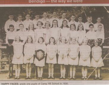 Bendigo Historical Society Inc.
Newspaper - JENNY FOLEY COLLECTION: HAPPY FACES
Camp Hill Primary School, No.1976, was built on the site of the Police Camp in 1877 and incorporated a fire lookout tower.Bendigo Advertiser ''The way we were'' from Monday, April 22, 2002. Happy faces: grade one pupils of Camp Hill school in 1930. The clip is in a folder.newspaper, bendigo advertiser, the way we were -
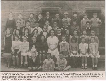 Bendigo Historical Society Inc.
Newspaper - JENNY FOLEY COLLECTION: SCHOOL DAYS
Camp Hill Primary School, No.1976, was built on the site of the Police Camp in 1877 and incorporated a fire lookout tower.Bendigo Advertiser ''The way we were'' from 2003. School days: the class of 1946, grade four students at Camp Hill Primary School. The clip is in a folder.newspaper, bendigo advertiser, the way we were -
 Stawell Historical Society Inc
Photograph, Christ Church -- Church of England on Church Hill Stawell, built 1862
Christ Church. Church of England on Church Hill Stawell. Built 1862. Part of a collection of Photographs by Mr. O.G. Armstrong as commissioned by the Shire of Stawell in 1866 for the Inter-colonial and Paris Exhibition in Melbourne in 1866. This was the first brick church in Stawell, the Christ Church, Stawell West, and was built on Church Hill off Seaby Street in approximately 1862. Opposite the original Manse in Seaby Street it was used for services in 1863. The present Church of England the Holy Trinity is situated in Main Street and was opened and dedicated on Trinity Sunday, May the 26th, 1872. Brick Church with small bell tower. Gum trees in front and at left.stawell religion -
 Melbourne Tram Museum
Photograph - St Vincents Plaza & Victoria Parade, Eastern Hill, late 1930s
... Hill Fire Station lookout tower over the intersection... Hill Fire Station lookout tower over the intersection ...Black and white photograph showing a view from the Eastern Hill Fire Station lookout tower over the intersection of Victoria Parade and Brunswick St, now known as St Vincents Plaza. There are three W2 class trams in the view. Has in the view the Eastern Hill Hotel, Penfolds Wines building on the former site of the Brunswick St / Victoria Parade engine house, the MMTB Traffic Offices, the MMTB substation, and the Bank Note Printing works. Yields information about the intersection of Victoria Parade and Brunswick St. late 1930s.Photograph with hand written notes on rear and stamps on the rear.In ink "Taken from the top of the Fire Station Eastern Hill, Melbourne.", The Argus copyright and the Ken Magor stamp.trams, tramways, w2 class, victoria parade, brunswick st, st vincent's plaza, engine houses -
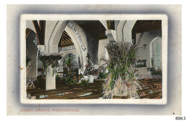 Flagstaff Hill Maritime Museum and Village
Postcard - Historical, Flagstaff Hill, Christ Church, Warrnambool, Early 20th century
The nine postcards in this set were donated together and date to the early 1900s. All but one postcard in this set shows images of Warrnambool, in the Western District of Victoria; the other has a London image. The postcards were all printed in Great Britain according to that country’s postal regulations. The fronts of all cards have titles printed in red. Most of the images on the cards are attributed to photographer Joseph Jordan and belong to the Jordan Series. The back of these cards has an outline for a postage stamp, a vertical dividing line and a heading on each side of the line to separate the Correspondence from the Address. Postcards or ‘correspondence cards’ appeared in Britain in 1894. They were plain cards with a space for the message on one side and an address on the other; regulations didn’t allow anything but the address to be written on the ‘address’ side. In 1902 the British regulations then allowed a picture to be printed on the front and the address on the back, so messages had to be written on the picture side. Soon, the regulations changed and the back was divided for a message and the address. Christ Church Warrnambool – The image on this card shows Christ Church, a stone building built in 1856. The Anglican church is in Henna Street, Warrnambool. The church, outer buildings and grounds are heritage-listed. Its bell tower harbours German bells. Joseph Jordan - Joseph Jordan was born in 1841 in Leicester England. When he was 16 he joined the 7th Queen's Own Hussars and was sent to India at the outbreak of the mutiny. He took part in the relief of Lucknow and remained in India for eleven years. It was during this time, he became interested in photography. He was posted to New Zealand and later came to Victoria, becoming a sergeant major of the Mounted Rifles. In the mid-1880s he came to the Western district where he was responsible for establishing units of the Mounted Rifles in various country towns such as Dunkeld, Mortlake, Panmure, Bushfield, Koroit etc. He resigned from the army in 1889 and set up a professional photography studio in Liebig Street, Warrnambool. He became very well known in the Western District for family photographs, official photographs of local councillors and groups as well as views of local scenery. In 1891 he photographed the wrecked barque ‘Fiji’ at ‘Wrecks Beach’ near Princetown. His business was taken over by his son Arthur around 1917. Joseph was a keen rifle shot and in 1924 he donated the "Jordan Shield" as a prize to the Victorian Rifle Association. He was made a "Life Honorary Member" of the Warrnambool Returned Soldiers League and in 1933 he was recognised as being the oldest living soldier in Victoria. Joseph died in 1935 aged 95.This card is the only one of the nine cards with the location of Warrnambool added to the name 'Joseph Series'. It is also the only one that has text within the outline for the postage stamp. The font used for the test of the headings is slightly different to the other cards. Joseph Jordan is a significant figure in Warrnambool history as he helped to establish early units of the Mounted Rifles (G Company) in local towns during the late 1880's and later, photographed local scenes, groups and citizens of early Warrnambool. This postcard of Christ Church Warrnambool is significant for its connection to the church. The early building of the church in 1856, within the first decade of Warrnambool being proclaimed a town, shows the strong religious desire of the community. The church is part of Warrnambool's life events and the historical significance of the building,Postcard, one of nine, landscape orientation, coloured print within an oval border and mauve-toned shading. The cameo image is of the Interior of the church chapel, with exposed timber beams, white arches decorated with flowers, pews with books on shelves, and organ pipes. There is text on the image. The title is in red print on the front of the card. The back has inscriptions and outlines for a postage stamp. There is no correspondence written on the card. Jordan Series, printed in Great Britain.Front, in red: “CHRIST CHURCH, WARRNAMBOOL” Back in black: “Jordan Series” “POST CARD” “PRINTED IN GREAT BRITAIN” “For correspondence” “The Address only to be written here” Text on the arch: "THE LORD OF HOSTS"flagstaff hill maritime museum, flagstaff hill maritime village, flagstaff hill maritime museum and village, maritime museum, warrnambool, great ocean road, warrnambool and district, warrnambool scenes, local scenes, views of warrnambool, joseph jordan, jordan series, jordan photography, postcard, souvenir, correspondence, cameo postcard, landscape, christ church, bell tower, german bells, warrnambool church, religious building, stone building, anglican church, parish of warrnambool, arch pillars -
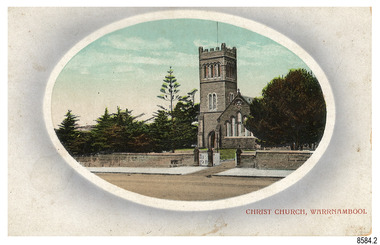 Flagstaff Hill Maritime Museum and Village
Postcard - Historical, Warrnambool, Christ Church, Warrnambool, Early 20th century
The nine postcards in this set were donated together and date to the early 1900s. All but one postcard in this set shows images of Warrnambool, in the Western District of Victoria; the other has a London image. The postcards were all printed in Great Britain according to that country’s postal regulations. The fronts of all cards have titles printed in red. Most of the images on the cards are attributed to photographer Joseph Jordan and belong to the Jordan Series. The back of these cards has an outline for a postage stamp, a vertical dividing line and a heading on each side of the line to separate the Correspondence from the Address. Postcards or ‘correspondence cards’ appeared in Britain in 1894. They were plain cards with a space for the message on one side and an address on the other; regulations didn’t allow anything but the address to be written on the ‘address’ side. In 1902 the British regulations then allowed a picture to be printed on the front and the address on the back, so messages had to be written on the picture side. Soon, the regulations changed and the back was divided for a message and the address. Christ Church Warrnambool – The image on this card shows Christ Church, a stone building built in 1856. The Anglican church is in Henna Street, Warrnambool. The church, outer buildings and grounds are heritage-listed. Its bell tower harbours German bells. Joseph Jordan - Joseph Jordan was born in 1841 in Leicester England. When he was 16 he joined the 7th Queen's Own Hussars and was sent to India at the outbreak of the mutiny. He took part in the relief of Lucknow and remained in India for eleven years. It was during this time, he became interested in photography. He was posted to New Zealand and later came to Victoria, becoming a sergeant major of the Mounted Rifles. In the mid-1880s he came to the Western district where he was responsible for establishing units of the Mounted Rifles in various country towns such as Dunkeld, Mortlake, Panmure, Bushfield, Koroit etc. He resigned from the army in 1889 and set up a professional photography studio in Liebig Street, Warrnambool. He became very well known in the Western District for family photographs, official photographs of local councillors and groups as well as views of local scenery. In 1891 he photographed the wrecked barque ‘Fiji’ at ‘Wrecks Beach’ near Princetown. His business was taken over by his son Arthur around 1917. Joseph was a keen rifle shot and in 1924 he donated the "Jordan Shield" as a prize to the Victorian Rifle Association. He was made a "Life Honorary Member" of the Warrnambool Returned Soldiers League and in 1933 he was recognised as being the oldest living soldier in Victoria. Joseph died in 1935 aged 95.This card is the only one of the nine cards with the location of Warrnambool added to the name 'Joseph Series'. It is also the only one that has text within the outline for the postage stamp. The font used for the test of the headings is slightly different to the other cards. Joseph Jordan is a significant figure in Warrnambool history as he helped to establish early units of the Mounted Rifles (G Company) in local towns during the late 1880's and later, photographed local scenes, groups and citizens of early Warrnambool. This postcard of Christ Church Warrnambool is significant for its connection to the church. The early building of the church in 1856, within the first decade of Warrnambool being proclaimed a town, shows the strong religious desire of the community. The church is part of Warrnambool's life events and the historical significance of the building,Postcard, one of nine, landscape orientation, coloured print within an oval border and mauve-toned shading. The cameo image is a stone castle-top bell tower beside a church building flanked by trees. A stone fence is across the front, with pedestrian and vehicle white picket gates. The title is in red print on the front of the card. There is no correspondence written on the card. The reverse has inscriptions and outlines for a postage stamp. Jordan Series, printed in Great Britain.Front, in red: “CHRIST CHURCH, WARRNAMBOOL” Back in black: “Jordan Series” “POST CARD” “PRINTED IN GREAT BRITAIN” “For correspondence” “The Address only to be written here”flagstaff hill maritime museum, flagstaff hill maritime village, flagstaff hill maritime museum and village, maritime museum, warrnambool, great ocean road, warrnambool and district, warrnambool scenes, local scenes, views of warrnambool, joseph jordan, jordan series, jordan photography, postcard, souvenir, correspondence, cameo postcard, landscape, christ church, bell tower, german bells, warrnambool church, religious building, stone building, anglican church, parish of warrnambool -
 Flagstaff Hill Maritime Museum and Village
Photograph - Historical, building, Late 19th to early 20th century
The black and white photograph depicts the Lady Bay Lighthouse Complex at Flagstaff Hill, Warrnambool. It was opened on this site in 1871. From left to right, the Chartroom (previously named the Store), Upper Lighthouse, Flagstaff, Lighthouse Keeper's Quarters. The bluestone buildings are facing North on Merri Street. The Harbour Pilot's Lodgings were on the east of the Complex. There are two unknown male figures standing in front of the light-coloured picket fence that encompasses the Complex. The photograph is mounted on card. WARRNAMBOOL'S LADY BAY LIGHTHOUSES In the 1800s ships sailing from England to Australia began to use Bass Strait as a faster route to Melbourne. Small navigation errors led to many tragic shipwrecks. From 1848 lighthouses were operating along Victoria’s southern coast as a guide for sailors. Coastal towns such as Warrnambool grew and the exchange of trade and passengers was of great benefit. However, the uncertain weather changes, relatively shallow waters and treacherous, hidden rocky reefs were not really suitable for a Harbour and in the 1840s and 1850s, there were many shipwrecks in the area, with some even stranded in its Lady Bay harbour. A jetty was built in 1850 and a flagstaff to guide seafarers was placed up high on what became known now as Flagstaff Hill. In November 1857 the Victorian Government recommended that Warrnambool Harbour had beacons and two lighthouses to guide vessels into and out of the Harbour safely. The white light of the Middle Island lighthouse was to be used for the first time on September 1, 1859. The red light of the Beach Lighthouse, a wooden obelisk structure, was first operated on March 25, 1860, but in 1868 this light was ‘discontinued’ due to it being too low. Melbourne’s Department of Public Works decided to relocate the Middle Island Lighthouse Complex - Lighthouse, Keeper’s Quarters, Privy, Store Room and even water tanks - to Flagstaff Hill. The lower obelisk was shortened, and a protruding gallery, railing, and external ladder were added, and the light from the Beach Lighthouse. A green guiding light was erected on the end of the jetty. The transfer of the Complex began in March 1871. Each shaped stone of the lighthouse was carefully numbered, removed then reassembled on Flagstaff Hill. In 1872 the well was sunk behind the Lighthouse Keeper’s Cottage. The Keepers and families had left Middle Island in April and moved to Flagstaff Hill in October 1871. Vessels entering Lady Bay align the Upper and Lower Lighthouse towers during the day and the lights at night. The Upper Lighthouse is a round tower, and the Lower Light is square. The Lighthouses were categorised as harbour lights rather than coastal lights, so they remain under the control of the Victorian Government’s Ports and Harbours section. The lights were originally powered by oil, then acetylene gas, later by electricity, and then converted to solar power in 1988. In 1993 the solar panel was replaced by a battery charger. A decision was made in 1936 to replace the lighthouses’ lights with unattended lights that no longer required Keepers and Assistants. At least 29 Keepers had attended to the lighthouse from its opening in 1859 to when the last official Lightkeepers left In April 1916. The Warrnambool Harbour Board rented out the Quarters from 1916 to 1936. The Board closed down but the rentals continued with other unknown landlords. In the 1970s the Flagstaff Hill Planning Board was set up under the chairmanship of John Lindsay. The Board was to make recommendations to the Warrnambool City Council regarding using the buildings and the rest of the Crown Land on the site. The Flagstaff Hill Maritime Village opened in 1975 and began renovating the Cottage in stages, during which time evidence of a 1920s fire was found in the eastern section of the cottage. Additions of a porch on the west and a washroom on the east were made in the 1980s. The western part of the building is now a Shipwreck Museum and the east has returned to a late 19th-century Lighthouse Keeper’s cottage and includes the screen made by Assistant Lighthouse Keeper Thomas Hope in the late 19th century. He served as Assistant Keeper in Warrnambool for two periods.The Warrnambool Lighthouse Complex is now listed on the Victorian Heritage Register, H1520, for being of historical, scientific (technological) and architectural significance to the State of Victoria. The Complex is significant as an example of early colonial development. The buildings are significant for their connection with the important navigational function of the Lighthouses, a function still being performed to this day. The buildings are also significant as an example of structures designed and works carried out by the Public Works Department in Victoria in the mid-to-late 19th century. The structures still stand strong. Photograph; Warrnambool Lighthouse Keeper's cottage, lighthouse, flagstaff and chartroom at Flagstaff Hill, and a light-coloured picket fence with gate. Two male figures are in front of the fence. Black and white print glued to a yellow card. The inscription is indecipherable. The right side of the cottage has a built-in, enclosed addition.Ink stamped in lower right hand corner, too faded to be legible.flagstaff hill, flagstaff hill maritime museum, flagstaff hill maritime village, warrnambool, maritime museum, shipwreck coast, lighthouse keeper's cottage, lighthouse residence, lighthouse, chart room, quarters, privy, middle island, beach lighthouse, obelisk, lighthouse complex, lady bay complex, warrnambool port, warrnambool harbour, lady bay, keepers, lighthouse keeper, upper lighthouse, lower lighthouse, assistant keeper, ports and harbours, cottage -
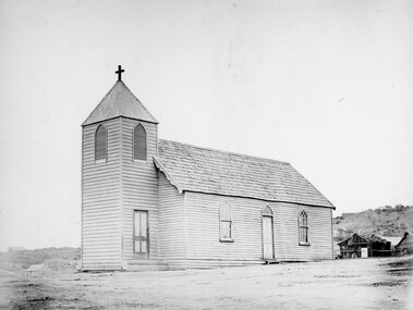 Stawell Historical Society Inc
Photograph, Wooden Catholic Church, Reefs Pleasant Creek, built about 1865
Wooden Catholic Church Reefs built about 1865. Part of a collection of Photographs by Mr. O.G. Armstrong as commissioned by the Shire of Stawell for the Inter-colonial and Paris Exhibition in Melbourne in 1866. This wooden building was built about 1865 on a site held by minors right, near the present Stawell Courthouse. It was situated on a track later to become Patrick St. The present St Patricks church is built of granite, quarried in the nearby Black Range with facings of Grampians Freestone and was opened in 1873. Wooden Church with large bell tower with door at front. The edge slope of Big Hill can be seen at right.stawell religion -
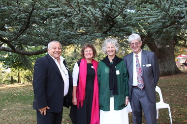 Ballarat Heritage Services
Photograph - Digital photographs, L.J. Gervasoni, Wombat Hill Botanic Gardens 150 anniversary event Daylesford organiser Gael Shannon, 2013
The Wombat Hill Botanic Gardens 150 anniversary event organiser was Gael Shannon. The Daylesford Botanic Gardens are of historic, scientific (botanic), and aesthetic significance to the State of Victoria. The Daylesford Botanic Gardens are historically significant as a fine example of a regional botanic garden demonstrating the typical characteristics of a carriage drive, informal park layout, decorative structures and works such as the memorial tower, conservatory, rotunda, cascade and fernery, which contrasts with the open lawns planted with specimen trees, areas of intensive horticultural interest and close proximity to a township developed during the mid to late nineteenth century. The Daylesford Botanic Gardens are historically significant for the design input by noted landscape designer William Sangster, and for the survival of his 1884 plan, which is a rare example of a plan from this prolific garden designer. The Daylesford Botanic Gardens are of scientific (botanic) significance for the extensive conifer collection and cool climate plants. The Gardens contain an outstanding collection of conifers and other mature trees, many of which were donated by renowned botanist Ferdinand von Mueller. Significant trees include Pinus ponderosa (Western Yellow Pine), Pinus coulteri (Big Cone Pine), twoAbies nordmanniana (Caucasian Fir), Abies pinsapo, (Spanish Fir) and a Cedrus atlantica f. glauca(Blue Atlas Cedar), Pinus wallichiana (Bhutan Pine), Pinus pinaster (Maritime Pine), Sequoiadendron giganteum (Giant Redwood), (Monkey Puzzle) and Aesculus hippocastanum (Horse Chestnut), many the largest or finest examples in Victoria. Other outstanding trees include a Tilia cordata (Small-leaved European Linden), a row of Cupressus lusitanica (Mexican cypress), a Quercus robur (English Oak) planted in 1863, avenues of Dutch Elms and a rare Quercus leucotrichophora (Himalayan Oak). The Daylesford Botanic Gardens are of aesthetic significance as a rare example of a botanic garden spectacularly sited on an extinct volcanic cone which allows a panoramic view, aided by the 1938 Pioneers’ Memorial Tower, as well as vistas within and out of the gardens and from the township to the gardens. As the most prominent local landmark, the Garden’s vertical dominance in the landscape provides a dark contrast to the elms avenues, oaks and other deciduous species. (Heritage Victoria Register, )Four people photographed at the 150th anniversary event at the Wombat Botanic Gardens.victoria, 150, anniversary, botanic, gardens, wombat hill, botanic gardens, heritage, celebration, garden party, daylesford, people, crowd, community, organiser, tour, gael shannon, don henderson, wombat hill botanic gardens -
 Ballarat Heritage Services
Photograph - Digital photographs, L.J. Gervasoni, Snow at the Wombat Hill Botanic Gardens, Daylesford, c2012-2016
The Daylesford Botanic Gardens are of historic, scientific (botanic), and aesthetic significance to the State of Victoria. The Daylesford Botanic Gardens are historically significant as a fine example of a regional botanic garden demonstrating the typical characteristics of a carriage drive, informal park layout, decorative structures and works such as the memorial tower, conservatory, rotunda, cascade and fernery, which contrasts with the open lawns planted with specimen trees, areas of intensive horticultural interest and close proximity to a township developed during the mid to late nineteenth century. The Daylesford Botanic Gardens are historically significant for the design input by noted landscape designer William Sangster, and for the survival of his 1884 plan, which is a rare example of a plan from this prolific garden designer. The Daylesford Botanic Gardens are of scientific (botanic) significance for the extensive conifer collection and cool climate plants. The Gardens contain an outstanding collection of conifers and other mature trees, many of which were donated by renowned botanist Ferdinand von Mueller. Significant trees include Pinus ponderosa (Western Yellow Pine), Pinus coulteri (Big Cone Pine), twoAbies nordmanniana (Caucasian Fir), Abies pinsapo, (Spanish Fir) and a Cedrus atlantica f. glauca(Blue Atlas Cedar), Pinus wallichiana (Bhutan Pine), Pinus pinaster (Maritime Pine), Sequoiadendron giganteum (Giant Redwood), (Monkey Puzzle) and Aesculus hippocastanum (Horse Chestnut), many the largest or finest examples in Victoria. Other outstanding trees include a Tilia cordata (Small-leaved European Linden), a row of Cupressus lusitanica (Mexican cypress), a Quercus robur (English Oak) planted in 1863, avenues of Dutch Elms and a rare Quercus leucotrichophora (Himalayan Oak). The Daylesford Botanic Gardens are of aesthetic significance as a rare example of a botanic garden spectacularly sited on an extinct volcanic cone which allows a panoramic view, aided by the 1938 Pioneers’ Memorial Tower, as well as vistas within and out of the gardens and from the township to the gardens. As the most prominent local landmark, the Garden’s vertical dominance in the landscape provides a dark contrast to the elms avenues, oaks and other deciduous species. (Heritage Victoria Register, )Digital imagesdaylesford, snow, weather, climate, winter, daylesford botanic gardens, botanic gardens, wombat hill, wombat hill botanic gardens, pinetum, trees, reservoir -
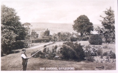 Ballarat Heritage Services
Photograph - Postcard, Wombat Hill Gardens, Daylesford
The Daylesford Botanic Gardens are of historic, scientific (botanic), and aesthetic significance to the State of Victoria. The Daylesford Botanic Gardens are historically significant as a fine example of a regional botanic garden demonstrating the typical characteristics of a carriage drive, informal park layout, decorative structures and works such as the memorial tower, conservatory, rotunda, cascade and fernery, which contrasts with the open lawns planted with specimen trees, areas of intensive horticultural interest and close proximity to a township developed during the mid to late nineteenth century. The Daylesford Botanic Gardens are historically significant for the design input by noted landscape designer William Sangster, and for the survival of his 1884 plan, which is a rare example of a plan from this prolific garden designer. The Daylesford Botanic Gardens are of scientific (botanic) significance for the extensive conifer collection and cool climate plants. The Gardens contain an outstanding collection of conifers and other mature trees, many of which were donated by renowned botanist Ferdinand von Mueller. Significant trees include Pinus ponderosa (Western Yellow Pine), Pinus coulteri (Big Cone Pine), twoAbies nordmanniana (Caucasian Fir), Abies pinsapo, (Spanish Fir) and a Cedrus atlantica f. glauca(Blue Atlas Cedar), Pinus wallichiana (Bhutan Pine), Pinus pinaster (Maritime Pine), Sequoiadendron giganteum (Giant Redwood), (Monkey Puzzle) and Aesculus hippocastanum (Horse Chestnut), many the largest or finest examples in Victoria. Other outstanding trees include a Tilia cordata (Small-leaved European Linden), a row of Cupressus lusitanica (Mexican cypress), a Quercus robur (English Oak) planted in 1863, avenues of Dutch Elms and a rare Quercus leucotrichophora (Himalayan Oak). The Daylesford Botanic Gardens are of aesthetic significance as a rare example of a botanic garden spectacularly sited on an extinct volcanic cone which allows a panoramic view, aided by the 1938 Pioneers’ Memorial Tower, as well as vistas within and out of the gardens and from the township to the gardens. As the most prominent local landmark, the Garden’s vertical dominance in the landscape provides a dark contrast to the elms avenues, oaks and other deciduous species. (Heritage Victoria Register, )Black and white postcard of Wombat Hill Botanical Gardens, Daylesford.wombat hill botanical gardens, daylesford, gardener, wombat hill botanic gardens