Showing 2589 items matching "aerial"
-
 Whitehorse Historical Society Inc.
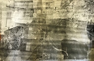
Map, Boronia Road, Vermont, 1970
Enlargement of aerial photograph of Boronia Road, Vermont. State Aerial Survey 1970 Run 37Enlargement of aerial photograph of Boronia Road, Vermont. State Aerial Survey 1970 Run 37Enlargement of aerial photograph of Boronia Road, Vermont. State Aerial Survey 1970 Run 37boronia road, vermont, lusk drive, vermont, morack road, vermont south, allison court, vermont, trinian street, vermont, cosgrove street, vermont, mawson court, vermont, aerial photographs -
Whitehorse Historical Society Inc.
Map, Boronia Road, Vermont, 1970
Enlargement of Aerial photograph of Boronia Road Vermont, State Aerial Survey, 1970. Run 37Enlargement of Aerial photograph of Boronia Road Vermont, State Aerial Survey, 1970. Run 37Enlargement of Aerial photograph of Boronia Road Vermont, State Aerial Survey, 1970. Run 37boronia road, vermont, gallus close, vermont, moore road, vermont, carlinga drive, vermont, beleura avenue, vermont, olinda crescent, vermont, penllyne avenue, vermont, holyrood drive, vermont, aerial photographs -
 Glenelg Shire Council Cultural Collection
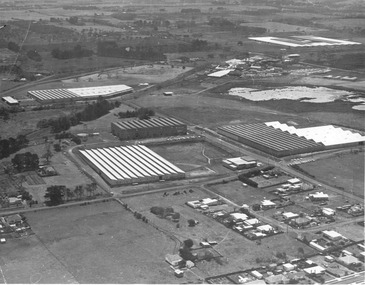
Photograph - Photograph - Southern Farmers & Australian Estates (Portland) Pty Ltd Wool Process, n.d
Port of Portland Authority archives.Front: (no inscriptions) Back: (no inscriptions)port of portland archives -
 Forests Commission Retired Personnel Association (FCRPA)
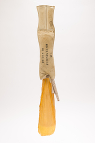
Drop Chute
From the early 1960s, the Forests Commission had pre-season arrangements in place with local aeroclubs and pilots across regional Victoria. Air observers from FCV districts routinely flew during the summer months in small, fixed-wing aircraft on fire spotting missions and to map fire boundaries. The information was often needed quickly by crews on the ground or in the control centre and these small chutes were used to drop messages and maps from the reconnaissance aircraft on a low pass above a cleared area like a football field. About 3-foot long when fully extended, they had a small pouch secured with a press stud for the map or package. The chutes were made from tough canvas with a small, weighted sandbag at one end and a long yellow streamer tail on the other to help direct its fall and locating it on the ground. Drop chutes were still in common use in the 1990s, but the increased availability of helicopters combined with improved digital data transfer made drop chutes redundant. Simple, but now redundant technologyAerial drop chute"Return to Forests Comm Vic" stenciled on sidebushfire -
 Friends of Ballarat Botanical Gardens History Group
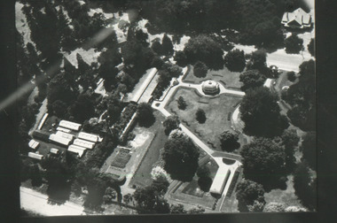
Slide - Black and white transparency
Aerial view of the gardensballarat botanical gardens, trees, parks, lawns, flowers, pounds, men, pathways, fernery, statuary pavilion -
 Department of Energy, Environment and Climate Action
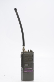
Sawtron portable radio
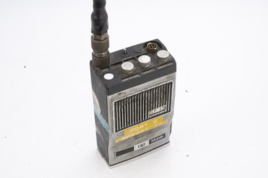
After the 1939 bushfires, the Forests Commission Victoria invested heavily in a radically new communications network. After suffering some inevitable delays due to the war, radio VL3AA switched into full operation in October 1945 proudly beaming out 200 watts across the State. But by today’s standards, the technology was primitive and the reception poor unless the user was on a high point somewhere. The radio signal was "line-of-sight" and bounced between fire towers and relay transmitters across the mountains back to the District offices. The advent of solid-state electronics in the 1960s replaced the more delicate valve sets which enabled greater use of vehicle mounted radios. The Commission continued to research, develop and build new radios at its many workshops around Victoria. The network was supported by a large team of skilled radio technicians. The more secure and versatile State Mobile Radio (SMR) digital trunk system came into operation in about 1995. Upgraded Tait Radios were purchased in 2014 after recommendations of the 2009 Bushfires Royal Commission. But it was the convergence of separate technologies such as 5G mobile phones, high-capacity and light-weight lithium batteries, Wi-Fi, the ever-expanding internet, cloud data storage, digital cameras, GPS, personal organisers and hundreds of supporting Apps into powerful smartphones and tablets which revolutionised bushfire communications from the mid-2000s. Portable radio with aerialSwifts Creek portable 7bushfire, radios, forests commission victoria (fcv) -
 Department of Energy, Environment and Climate Action
ITT Portable radio
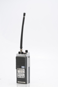
After the 1939 bushfires, the Forests Commission Victoria invested heavily in a radically new communications network. After suffering some inevitable delays due to the war, radio VL3AA switched into full operation in October 1945 proudly beaming out 200 watts across the State. But by today’s standards, the technology was primitive and the reception poor unless the user was on a high point somewhere. The radio signal was "line-of-sight" and bounced between fire towers and relay transmitters across the mountains back to the District offices. The advent of solid-state electronics in the 1960s replaced the more delicate valve sets which enabled greater use of vehicle mounted radios. The Commission continued to research, develop and build new radios at its many workshops around Victoria. The network was supported by a large team of skilled radio technicians. The more secure and versatile State Mobile Radio (SMR) digital trunk system came into operation in about 1995. Upgraded Tait Radios were purchased in 2014 after recommendations of the 2009 Bushfires Royal Commission. But it was the convergence of separate technologies such as 5G mobile phones, high-capacity and light-weight lithium batteries, Wi-Fi, the ever-expanding internet, cloud data storage, digital cameras, GPS, personal organisers and hundreds of supporting Apps into powerful smartphones and tablets which revolutionised bushfire communications from the mid-2000s. Portable radio with aerialCFL Orbost Regionbushfire, radios, forests commission victoria (fcv) -
 Department of Energy, Environment and Climate Action
YAESU Portable radio FTC 2300
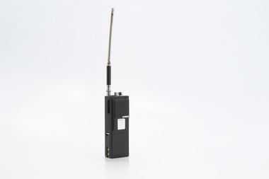
After the 1939 bushfires, the Forests Commission Victoria invested heavily in a radically new communications network. After suffering some inevitable delays due to the war, radio VL3AA switched into full operation in October 1945 proudly beaming out 200 watts across the State. But by today’s standards, the technology was primitive and the reception poor unless the user was on a high point somewhere. The radio signal was "line-of-sight" and bounced between fire towers and relay transmitters across the mountains back to the District offices. The advent of solid-state electronics in the 1960s replaced the more delicate valve sets which enabled greater use of vehicle mounted radios. The Commission continued to research, develop and build new radios at its many workshops around Victoria. The network was supported by a large team of skilled radio technicians. The more secure and versatile State Mobile Radio (SMR) digital trunk system came into operation in about 1995. Upgraded Tait Radios were purchased in 2014 after recommendations of the 2009 Bushfires Royal Commission. But it was the convergence of separate technologies such as 5G mobile phones, high-capacity and light-weight lithium batteries, Wi-Fi, the ever-expanding internet, cloud data storage, digital cameras, GPS, personal organisers and hundreds of supporting Apps into powerful smartphones and tablets which revolutionised bushfire communications from the mid-2000s. Portable radio with aerial Bendigo Region 09/144 Res Conbushfire, radios, forests commission victoria (fcv) -
 Department of Energy, Environment and Climate Action
Midland Portable radio
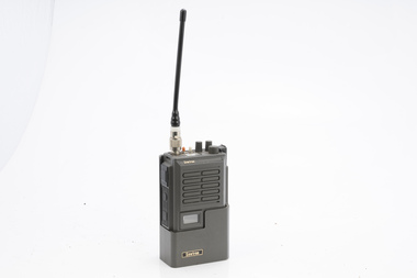
After the 1939 bushfires, the Forests Commission Victoria invested heavily in a radically new communications network. After suffering some inevitable delays due to the war, radio VL3AA switched into full operation in October 1945 proudly beaming out 200 watts across the State. But by today’s standards, the technology was primitive and the reception poor unless the user was on a high point somewhere. The radio signal was "line-of-sight" and bounced between fire towers and relay transmitters across the mountains back to the District offices. The advent of solid-state electronics in the 1960s replaced the more delicate valve sets which enabled greater use of vehicle mounted radios. The Commission continued to research, develop and build new radios at its many workshops around Victoria. The network was supported by a large team of skilled radio technicians. The more secure and versatile State Mobile Radio (SMR) digital trunk system came into operation in about 1995. Upgraded Tait Radios were purchased in 2014 after recommendations of the 2009 Bushfires Royal Commission. But it was the convergence of separate technologies such as 5G mobile phones, high-capacity and light-weight lithium batteries, Wi-Fi, the ever-expanding internet, cloud data storage, digital cameras, GPS, personal organisers and hundreds of supporting Apps into powerful smartphones and tablets which revolutionised bushfire communications from the mid-2000s. Portable radio with aerial Hopetounbushfire, radios, forests commission victoria (fcv) -
 Department of Energy, Environment and Climate Action
Sawtron portable radio
After the 1939 bushfires, the Forests Commission Victoria invested heavily in a radically new communications network. After suffering some inevitable delays due to the war, radio VL3AA switched into full operation in October 1945 proudly beaming out 200 watts across the State. But by today’s standards, the technology was primitive and the reception poor unless the user was on a high point somewhere. The radio signal was "line-of-sight" and bounced between fire towers and relay transmitters across the mountains back to the District offices. The advent of solid-state electronics in the 1960s replaced the more delicate valve sets which enabled greater use of vehicle mounted radios. The Commission continued to research, develop and build new radios at its many workshops around Victoria. The network was supported by a large team of skilled radio technicians. The more secure and versatile State Mobile Radio (SMR) digital trunk system came into operation in about 1995. Upgraded Tait Radios were purchased in 2014 after recommendations of the 2009 Bushfires Royal Commission. But it was the convergence of separate technologies such as 5G mobile phones, high-capacity and light-weight lithium batteries, Wi-Fi, the ever-expanding internet, cloud data storage, digital cameras, GPS, personal organisers and hundreds of supporting Apps into powerful smartphones and tablets which revolutionised bushfire communications from the mid-2000s. Portable radio with aerialKG109 - 40DO 5KWbushfire, radios, forests commission victoria (fcv) -
4th/19th Prince of Wales's Light Horse Regiment Unit History Room
Aerial Tuning Unit No 8, 1950s - 60s
Aerial Tuning Unit No 8. Box of aluminium construction with controls for tuning the aerial of the B47 wireless set.ZA 46835aerial tuning, b47 radio -
Whitehorse Historical Society Inc.
Map, Boronia Road, Canterbury Road intersection, c1970
Enlarged aerial photograph of the intersection of Canterbury and Boronia Roads. State Aerial Survey, Melbourne 1970 project.Enlarged aerial photograph of the intersection of Canterbury and Boronia Roads. State Aerial Survey, Melbourne 1970 project.Enlarged aerial photograph of the intersection of Canterbury and Boronia Roads. State Aerial Survey, Melbourne 1970 project.boronia road, vermont, canterbury road, vermont, mitcham road, vermont, frances avenue, vermont, nurlendi road, vermont, beaumont street, vermont, kingsclere street, vermont, webb court, vermont, aerial photographs -
Whitehorse Historical Society Inc.
Map, Canterbury Road, Vermont, c1970
Enlarged aerial photo of intersection of Canterbury and Boronia Roads. State Aerial Survey, Melbourne 1970 project.Enlarged aerial photo of intersection of Canterbury and Boronia Roads. State Aerial Survey, Melbourne 1970 project.Enlarged aerial photo of intersection of Canterbury and Boronia Roads. State Aerial Survey, Melbourne 1970 project.canterbury road, vermont, boronia road, vermont, mitcham road, vermont, frances avenue, vermont, nurlendi road, vermont, webb court, vermont, vermont primary school, no. 1022, aerial photographs -
 City of Kingston
Photograph - Colour, c. 1982
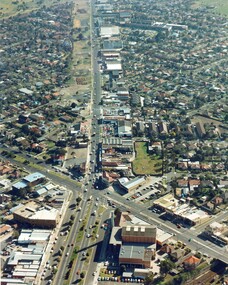
This aerial photograph of South Road and Nepean Highway, Moorabbin shows the area where houses and shops on the south side of the Nepean Highway have demolished for the widening of the highway. The pressures of rapid urban development in Moorabbin and beyond, especially to the south of Moorabbin caused bottlenecks and delays, especially at the South Road and Nepean Highway intersection, hence the scheme to widen Nepean Highway.The pressures of rapid urban development in terms of people, housing construction, industrial development and commercial activity, in Moorabbin and beyond, especially to the south would put pressure on road infrastructure in the region. In the early 1980s, a major road expansion of the Nepean Highway was implemented to increase capacity on this major thoroughfare for vehicle commuters. Car use had also increased with commuters from the increasingly populous southern suburbs travelling to their place of work in the Melbourne CBD.Colour photograph of an aerial view of South Road and Nepean Highway, Moorabbin. The image shows houses on the south side of the Nepean Highway that have demolished for widening of road. It features housing and commercial buildings looking north towards Cummins Road.Handwritten blue ink: 82 - 5452 - 11 Handwritten red ink: 112% Handwritten black ink: Ch. 7nepean highway, south road, moorabbin, roads, transport, infrastructure -
 Port Melbourne Historical & Preservation Society
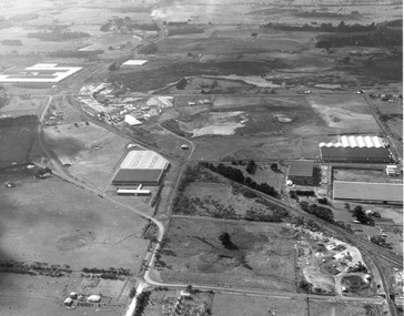
Photograph - Aerial view of J Kitchen & Sons site, Port Melbourne
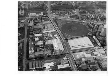
The source of the images is unknown. The date has been estimated in reference to catalogue items 2989 (approx 1945) and 2990 (approx 1970) - both aerial photos of the area.Two black and white aerial photos of J Kitchen & Sons factory prrecinct, approximately 1960s. .01- Looking towards the East with Ingles St in the centre and Port Melbourne cricket/football ground on the right. Rail line is at the top. The Kitchen property is outlined. .02 - Looking towards the North with Port Melbourne cricket/football ground at the bottom, Kitchens (outlined) in the centre and other industrial to the North.built environment - industrial, industry - manufacturing, sport - australian rules football, business and traders - soaps/candles, j kitchen & sons pty ltd, port melbourne football and cricket ground, north port oval -
 Bayside Gallery - Bayside City Council Art & Heritage Collection
Photograph, Department of Crown Lands and Survey, Victoria, Brighton, Brighton East and Bentleigh, c. 1965-71
The Department of Crown Lands and Survey (1857-1983) was responsible for the administration of survey and mapping and the sale, occupation and management of crown land throughout its existence. This aerial photograph shows parts of Brighton, Brighton East and Bentleigh and was taken circa 1965-71.brighton, department of crown lands and survey, aerial photograph, bayside, port phillip bay, map, cartographic material, bentleigh, brighton east, dendy park, dendy street, centre road, nepean highway, south road, football -
 Bendigo Military Museum
Booklet - RAEME BOOKLET, Ian Beaton, 4th Base Workshop Battalion
1. Booklet outlines the work carried out by 4th Workshop Battalion, Bandiana, Victoria. Part of the Cooper Collection. 2. Aerial photograph of Bandiana workshops.1. A4 sized booklet with twelve pages secured to cover with two staples. Front cover has RAEME insignia in gold and silver on a black background. Title in gold and silver lettering. Pages contain colour photographs and text in white. Pages have a black background. 2. Colour aerial photograph of a group of buildings at Bandiana. 3. Business card featuring RAEME insignia and text in blue print.cooper collection, bandiana, 4th workshop battalion, raeme -
 Bayside Gallery - Bayside City Council Art & Heritage Collection
Photograph, Department of Crown Lands and Survey, Victoria, Brighton, Brighton East and Bentleigh, c. 1965-71
The Department of Crown Lands and Survey (1857-1983) was responsible for the administration of survey and mapping and the sale, occupation and management of crown land throughout its existence. This aerial photograph shows parts of Brighton and Brighton East and was taken circa 1965-71.brighton, department of crown lands and survey, aerial photograph, bayside, port phillip bay, map, cartographic material, brighton east, dendy park, dendy street, centre road, nepean highway, south road, brighton golf course, golf -
 Bendigo Military Museum
Instrument - Universal Stereoscope - boxed, 1940
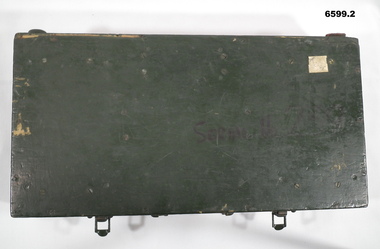
The Universal Stereoscope was used to view overlapping stereo aerial photography in three dimensions (3D). It consists of magnifying lenses, an optical train including glass prisms and mirrors that are protected by sliding metal covers, all suspended on a pair of fold out adjustable legs. The Universal Stereoscope was produced in Australia in 1940 for military use and has its protective wooden box. It was used extensively by members of the Australian Army Survey Corps during WWII in many theatres of war for viewing and annotating aerial photography. See also photograph at 6205.6P. 6205.1P shows the Universal Stereoscope in use by Royal Australian Survey Corps annotating Aerial Photography.6599.1 Wooden Box that contains a Universal Stereoscope. 6599.2 Open Wooden Box showing a folded Universal Stereoscope. A dark green wooden box containing a Universal Stereoscope with spare mirrors. The Universal Stereoscope was used to view overlapping stereo aerial photography in three dimensions (3D). It consists of magnifying lenses, an optical train including glass prisms and mirrors that are protected by sliding metal covers, all suspended on a pair of fold out adjustable legs. The stereoscope is painted a dark green colour."DC 1940" "Serial (Number) - 239 D>D"royal australian survey corps, rasvy, fortuna, army survey regiment, army svy regt -
 City of Kingston
Photograph - Black and white, 20 December 1945
This aerial photograph depicts the changing landscape of Cheltenham and Highett since WWII. Photographed in 1945, there is a mix of urban dwellings and industrial development and precedes the major transformation of Cheltenham with the development of the Southland shopping centre in the 1960s and expansion in the 1990s.A large part of Cheltenham was originally established as a rural market gardening community. The railway line and station brought urban development to the area and in the north, the Highett area was dominated by the Highett Gas Works. Cheltenham became a major destination for shopping in the 1960s with the opening of Southland.Aerial photograph taken in 1945 of Cheltenham and Highett within the City of Kingston. The image includes the Highett Reserve, (top right), the Methodist Children Homes (now Southland), Nepean Highway and Jamieson Street. Highett Gas Works is visible in the top left and the land now named William Fry Reserve at the intersection of Bay Road and Nepean Highway. A visible large parcel of land on the corner of Bay Road and Nepean Highway was developed in the 1990s as the west side addition to Southland. The densely vegetated area in the upper right sector of the image is now dense with housing. Tulip Grove, Heather Grove and Gilford Street are visible bottom left. This image is possibly from the collection of aerial photographs commissioned by the Department of Crown Lands and Survey and taken by Adastra Airways.Black ink: 57252 White lettering: VIC-10 57252 20.12.45 [lens information indecipherable] PROJ. No.5 MELB. METROP AREA Black pencil: 80highett, cheltenham, highett gas works, urbanisation -
 City of Kingston
Photograph - Black and white, 20 December 1945
This aerial photograph depicts the changing landscape of Cheltenham and Highett since WWII. Photographed in 1945, there is a mix of urban dwellings and industrial development and precedes the major transformation of Cheltenham with the development of the Southland shopping centre in the 1960s and expansion in the 1990s.A large part of Cheltenham was originally established as a rural market gardening community. The railway line and station brought urban development to the area and in the north, the Highett area was dominated by the Highett Gas Works. Cheltenham became a major destination for shopping in the 1960s with the opening of Southland.Aerial photograph taken in 1945 of Cheltenham and Highett within the City of Kingston. The image includes the Highett Reserve, (top right), the Methodist Children Homes (now Southland), Nepean Highway and Jamieson Street. Highett Gas Works is visible in the top left and the land now named William Fry Reserve at the intersection of Bay Road and Nepean Highway. A visible large parcel of land on the corner of Bay Road and Nepean Highway was developed in the 1990s as the west side addition to Southland. The densely vegetated area in the upper right sector of the image is now dense with housing. Tulip Grove, Heather Grove and Gilford Street are visible bottom left. This image is possibly from the collection of aerial photographs commissioned by the Department of Crown Lands and Survey and taken by Adastra Airways.Black type: Reverse lettering VIC-10 57252 20.12.45 [lens information indecipherable] PROJ. No.5 MELB. METROP AREA White lettering: Reverse writing 57252cheltenham, highett, highett gas works, urbanisation -
 Federation University Historical Collection
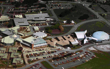
Photograph, Gippsland Campus
Aerial photograph of Gippsland Campuschurchill campus, gippsland campus, gippsland institute of advanced education, gippsland campus collection -
 Phillip Island and District Historical Society Inc.
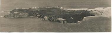
Photograph, Bryant West
One of a collection of over 400 photographs in an album commenced in 1960 and presented to the Philip Island & Westernport Historical Society by the Shire of Phillip IslandAerial Photograph of Cape Woolamai.local history, photography, photographs, coastline, cape woolamai, phillip island, john jenner, bryant west -
 Greensborough Historical Society
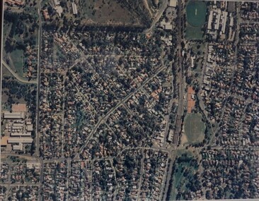
Aerial Photograph, Macleod, 1980c
Covers Macleod area. Section of 5994.Laminated colour aerial photographmacleod -
 Greensborough Historical Society
Aerial Photograph, Photo-mapping Services Pty Ltd, Macleod, 1980c
Covers Macleod, Bundoora and Greensborough areasLaminated colour aerial photographmacleod, bundoora, greensborough -
 Greensborough Historical Society
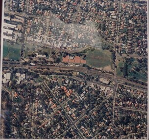
Aerial Photograph, Watsonia, Greensborough, 1945c
Covers Greensborough, Watsonia and Macleod areasBlack and white aerial photographgreensborough, watsonia, macleod -
 Glenelg Shire Council Cultural Collection
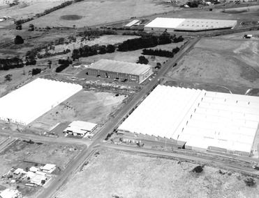
Photograph - Photograph - Aerial view of Australian Estates (Portland) Pty Ltd Wool Process, n.d
Port of Portland Authority archives.Front: (no inscriptions) Back: (no inscriptions)port of portland archives -
 Glenelg Shire Council Cultural Collection
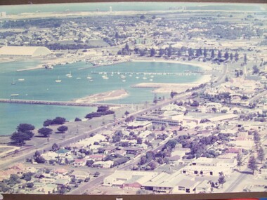
Photograph - Photograph - Portland Foreshore, n.d
Glenelg Shire Council RecordsAerial view of Portland foreshore.Front: (no inscriptions) Back: Portland Studios/11 Julia St., Portland 3305. Tel. 232224 (black stamp centre top). Portland Development Committee Archive Material (black pen, upper centre). Portland Development Committee Inc. (blue ink stamp, centre).portland foreshore -
 Glenelg Shire Council Cultural Collection
Photograph, Southern Farmers & Australian Estates (Portland) Pty Ltd Wool Process, n.d
Port of Portland Authority archives.Front: (no inscriptions) Back: Portland Harbor Trust Commissioners (purple stamp, top left & bottom right)port of portland -
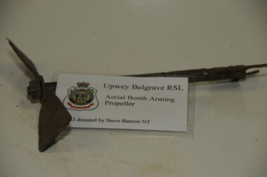 Running Rabbits Military Museum operated by the Upwey Belgrave RSL Sub Branch
Shell Fuse
Aerial Bomb Arming Propellerammunition, raaf