Showing 1160 items
matching dairy
-
 Warrnambool and District Historical Society Inc.
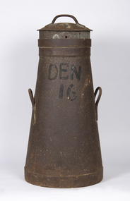
Container - Milk can, Early 20th century
This is a can used for storing milk at a dairy farm for transport to the local butter, milk or cheese factory. It comes from a farm (number 16) in Dennington, a settlement and now a suburb west of Warrnambool. It may have been supplying milk to the Nestles factory at Dennington by a truck or taken to a Nestles depot nearby. The Nestles factory was established in Dennington in 1907 and closed in 2005. This can is an interesting memento of dairying practices in the early to mid 20th century.This is a metal can with a circular base tapering to an open top. It has two handles on the side and a circular lid with a handle. It has a stencil on the side. The entire can is rusted.Den 16milk can, dairying in warrnambool district, nestles factory dennington -
 Greensborough Historical Society
Photograph - Digital Image, Cherel Sartori, Kell's Cottage, 01/01/1956
Photograph of Kell's Cottage. The house was built 1917, at 112 Henry Street Greensborough by William Mitchell on the 60 acre dairy farm owned by Ethel and Walter Kell. This collection of photographs was copied by Cherel Sartori (who owned the house from 1990-2000), following a visit by Claude Amiet who lived in the house as a child in the early 20th century.Digital copy of black and white photographkell's cottage, claude amiet, cherel sartori -
 Greensborough Historical Society
Photograph - Digital Image, Cherel Sartori, Kell's Cottage 1940s, 01/01/1956
Photograph of Kell's Cottage in the 1940s. The house was built 1917, at 112 Henry Street Greensborough by William Mitchell on the 60 acre dairy farm owned by Ethel and Walter Kell. This collection of photographs was copied by Cherel Sartori (who owned the house from 1990-2000), following a visit by Claude Amiet who lived in the house as a child in the early 20th century.Digital copy of black and white photographkell's cottage, claude amiet, cherel sartori -
 Greensborough Historical Society
Photograph - Digital Image, Cherel Sartori, Kell's Cottage, 01/01/1956
Photographs of Kell's Cottage in the 1940s. The house was built 1917, at 112 Henry Street Greensborough by William Mitchell on the 60 acre dairy farm owned by Ethel and Walter Kell. This collection of photographs was copied by Cherel Sartori (who owned the house from 1990-2000), following a visit by Claude Amiet who lived in the house as a child in the early 20th century.Digital copy of 3 black and white photographkell's cottage, claude amiet, cherel sartori -
 Kiewa Valley Historical Society
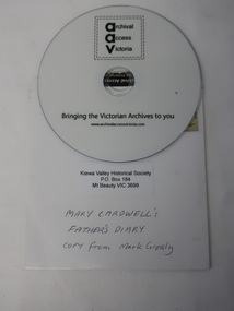
DVD - Mary Cardwell's Father's Diary
Dairy farmers kept a journal to record their transactions and business on the farm. John Creamer' daughter, Mary Cardwell has her father's journal covering the years 1916 to 1942. Mark Grealy digitised the journal for KVHS to preserve the contents and to make it available to the public at the PRO as an item of significance. DVDs have been replaced by USB sticks as technology advances.The journal was kept by local dairy farmer John Creamer, who farmed at Gundowring in the Kiewa Valley. It consists of names of local people and is representative of the business (produce and life) on the dairy farm at the time. DVDs are a digitised version of the Journal and require a computer to be able to play it as technology advances.DVD is white with black print:on the front: 'AAV' / 'Archival Access Victoria / Bringing the Victorian Archives to you / www.archivalaccessvictoria.com. The DVD is in a white cardboard sleeve with a postage stamp, KVHS address and Title: 'Mary Cardwell's / Father's Diary / Copy from Mark Grealy' Ref: KVHS 0947As Above. dairy industry, creamer family, gundowring, dvd dairy farm journal -
 City of Moorabbin Historical Society (Operating the Box Cottage Museum)
Album - B/W Kodak album 24pp WW1 1914-1919, c1914-1918
The photos in this album show the carefree, adventurous spirit of the young men soon to be ANZACS Many young men from the market garden, dairy, poultry and fruit farms as well local businesses enlisted c 1914 at the beginning of WWI. The older men, women and children then had to manage the farms while they worried about the dangers facing their beloved family members. A record of some of the experiences of men from Moorabbin Shire who enlisted c1914 and were sent to Egypt at the beginning of WW1 1914-19A thick cardboard album of 24 pages with inserts for 2 small black and white photographs per page . Scenes from Egypt c 1914 - 1918 showing Australian soldiers, naval vessels, horses, carts, pyramids, houses, buildings, camels, local inhabitants and countryside. Inscriptions on the back of some of the photographs mention Arthur (Ebsary), Clarrie (Burgess), Reg (Marriott), and a horse named Nell.Front cover KODAK Inside back cover KODAK LTD. / SERIES D / ALBUM Some photographs have inscriptions on the backww1 1914-1918, photographs, australian light horse battalion, egypt, 1st australian infantry force, war horses, kodak ltd, wwi, moorabbin, burgess, marriott -
 Bendigo Historical Society Inc.
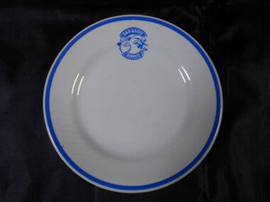
Functional object - Dad and Dave Cafe Small Plate
Dad & Dave Cafe was located in Pall Mall Charing Cross Bendigo. It was opened by dairy farmer and milk bar owner Les McClure in 1939. His Four'n Twenty meat pies were initially made in Bendigo in 1947. McClure sold his Four'n Twenty Pie's Pty. Ltd. to Peters Ice Cream (VIC) Ltd. in 1960.A small plate 16 centimetres diameter and two centimetres high. It's white with a blue trim on the edge and a blue circular logo -DAD & DAVE BENDIGO with Dad and Dave faces in the middle. . On the back is a maker's logo- "DURALINE" SUPER VITRIFIED GRINDLEY HOTEL WARE Co LOFTUS MORAN PTY.Lo MELBOURNE 12-53ceramics, loftus moran melbourne, "duraline" grindley hotel ware co england, dad and dave bendigo, lesle thompson mcclure -
 Bendigo Historical Society Inc.
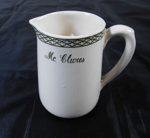
Functional object - McClures Milk Jug
Dad & Dave Cafe was located in Pall Mall Charing Cross Bendigo. It was opened by dairy farmer and milk bar owner Les McClure in 1939. His Four'n Twenty meat pies were initially made in Bendigo in 1947. McClure sold his Four'n Twenty Pie's Pty. Ltd. to Peters Ice Cream (VIC) Ltd. in 1960.A cream coloured jug with green decorative trim and McClures on it. Its ten centimetres high, eight and half centimetres diameter at its base six centimetres at the top with a small spout. Opposite the spout there is a curved handle that's one centimetre wide and seven centimetres heigh.ceramics, dad and dave bendigo, leslie thompson mcclure -
 Warrnambool and District Historical Society Inc.
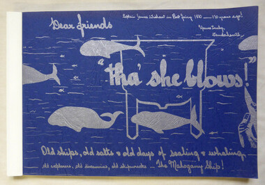
Book, Vanda Savill (1913-2005), Tha' she blows, 1980
Scrapbook style book history of early Port Fairy and PortlandThis is a paper back book of 176 pages. The pages are bound together. The cover is blue card with silver-coloured wording and illustrations of whales. There are 829 photographs and illustrations. The historical material contained in the pages is handwritten and photocopied. non-fictionScrapbook style book history of early Port Fairy and Portlandwhaling, port fairy, portland, shipwrecks -
 Kew Historical Society Inc
Archive (Sub-series) - Subject File, Elm House, 72 Walpole Street (Kew), 1983
Sally Ann VenablesReference, Research, InformationProvenance (Donor) OrderSubject file containing a school research assignment completed by Sally Ann Venables of the history of Elm House (later Cloverlea), 72 Walpole Street. The 15-page report was completed in 1983 while Sally was a pupil of Kew High School. Owners of the house recorded in the report include Horace Samson, George Gray Allan, George Brinsden Vasey, Matthew Montgomerie Wilson, and Ethel Dalton. The writer contends that at some stage, the house operated as a dairy. kew (vic) - history, kew (vic) - dairies, elm house - 72 walpole street (kew), cloverlea - 72 walpole street (kew), sally ann venables, houses - walpole street - kew (vic)kew (vic) - history, kew (vic) - dairies, elm house - 72 walpole street (kew), cloverlea - 72 walpole street (kew), sally ann venables, houses - walpole street - kew (vic) -
 Kew Historical Society Inc
Photograph - Yarra River, Kew, 1925
Henry Beater Christian (1886-1962) , was a descendant of one of the earliest settler families in Kew. Employed at the Kew Asylum as a 'public servant', he was a skilled amateur photographer, photographing numerous scenes in Kew and on his travels around Victoria. The majority of his photographs date from 1916 to 1929. His finest photographs are housed in two photograph albums. Digital copy of a photograph from page 3 of the 47-page photograph album containing 261 gelatinous silver images, loaned by Diane Washfold with permission given to digitise and hold a copy in our collection. A photograph of a stretch of the Yarra River at Kew. From the 1840s, at the Crown Land Sales, lots adjacent to the river were sold and developed as dairy farms, hence the presence of cattle until the land was subdivided or created into golf courses during the twentieth century. "Yarra Rvr / Kew / 1925"henry beater christian (1886-1962), landscape photography, kew (vic.) — yarra river, christian-washfold collection, photograph albums, dairying -- kew (vic.) -
 Kiewa Valley Historical Society
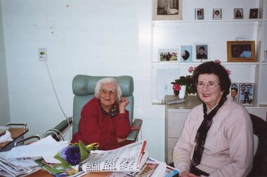
Colour photograph of Nesta Drew and her former teacher
Mrs Nesta Drew is a longtime resident of Tawonga having operated a dairy farm with her family on the Kiewa Valley Highway in Tawonga. She grew up in the area and attending local schools and raised her own family there, until selling up the family home and moving into an aged care facility in recent years. Some of her family still reside in the local area. Mrs Drew is a well known community figure in the Tawonga area with links to many social and family groups. She has a very strong historical connection to Tawonga and has been a reliable source of anecdotal local historical knowledge. Colour photograph of Mrs Nesta Drew visiting her former teacher Miss Edna Jenkins. Explanation of photograph handwritten on the back by Mrs Drew (see photograph above) -
 Greensborough Historical Society
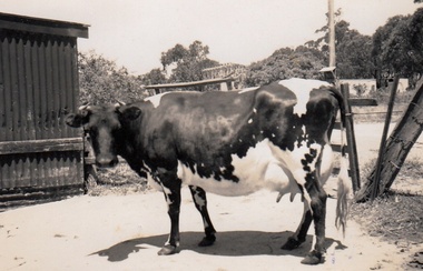
Photograph - Digital Image, Cherel Sartori, Cows at Kell's Cottage 1956, 01/01/1956
Photograph of a cow at Kell's Cottage in the 1940s. The house was built 1917, at 112 Henry Street Greensborough by William Mitchell on the 60 acre dairy farm owned by Ethel and Walter Kell. This collection of photographs was copied by Cherel Sartori (who owned the house from 1990-2000), following a visit by Claude Amiet who lived in the house as a child in the early 20th century.An indication of the rural aspect of this area in the mid-20th century.Digital copy of black and white photographkell's cottage, claude amiet, cherel sartori -
 Greensborough Historical Society
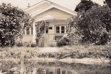
Photograph - Digital Image, Cherel Sartori, Electricity connected in Henry Street, 1950s, 1956c
Kell's Cottage with electricity connected 1950s. The house was built 1917, at 112 Henry Street Greensborough by William Mitchell on the 60 acre dairy farm owned by Ethel and Walter Kell. This collection of photographs was copied by Cherel Sartori (who owned the house from 1990-2000), following a visit by Claude Amiet who lived in the house as a child in the early 20th century.An indication of the rural aspect of this area in the mid-20th century.Digital copy of black and white photographkell's cottage, claude amiet, cherel sartori -
 Greensborough Historical Society
Photograph - Digital Image, Cherel Sartori, Paddock and gates in Henry Street, 1950s, 1956c
Paddock and driveway at Kell's Cottage 1950s. The house was built 1917, at 112 Henry Street Greensborough by William Mitchell on the 60 acre dairy farm owned by Ethel and Walter Kell. This collection of photographs was copied by Cherel Sartori (who owned the house from 1990-2000), following a visit by Claude Amiet who lived in the house as a child in the early 20th century.An indication of the rural aspect of this area in the mid-20th century.Digital copy of black and white photographkell's cottage, claude amiet, cherel sartori -
 Greensborough Historical Society
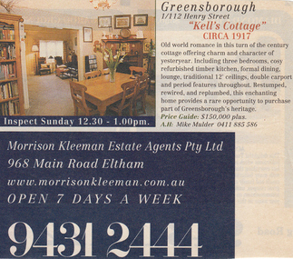
Photograph - Digital Image, Cherel Sartori, Sale notices, Kell's Cottage, 2000, 2000_
Advertisements for Kell's Cottage when sold in 2000. The house was built 1917, at 112 Henry Street Greensborough by William Mitchell on the 60 acre dairy farm owned by Ethel and Walter Kell. This collection of photographs was copied by Cherel Sartori (who owned the house from 1990-2000), following a visit by Claude Amiet who lived in the house as a child in the early 20th century.Digital copy of colour advertisementskell's cottage, claude amiet, cherel sartori -
 Greensborough Historical Society
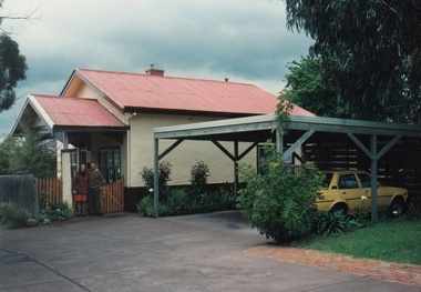
Photograph - Digital Image, Cherel Sartori, Exterior of Kell's Cottage, 2000, 2000_
Exterior of Kell's Cottage when sold in 2000. The house was built 1917, at 112 Henry Street Greensborough by William Mitchell on the 60 acre dairy farm owned by Ethel and Walter Kell. This collection of photographs was copied by Cherel Sartori (who owned the house from 1990-2000), following a visit by Claude Amiet who lived in the house as a child in the early 20th century.Digital copy of colour photographskell's cottage, claude amiet, cherel sartori -
 Greensborough Historical Society
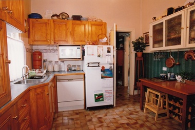
Photograph - Digital Image, Cherel Sartori, Interior of Kell's Cottage, 2000, 2000_
Interior of Kell's Cottage when sold in 2000. The house was built 1917, at 112 Henry Street Greensborough by William Mitchell on the 60 acre dairy farm owned by Ethel and Walter Kell. This collection of photographs was copied by Cherel Sartori (who owned the house from 1990-2000), following a visit by Claude Amiet who lived in the house as a child in the early 20th century.Digital copy of 4 colour photographskell's cottage, claude amiet, cherel sartori -
City of Moorabbin Historical Society (Operating the Box Cottage Museum)
Tools, Slide-hammer Nail puller,c1880, c1880
c1880 Many tools were imported from USA manufacturers by early settlers in Moorabbin Shire and local blacksmiths modified and maintained these tools for the other settlers who were establishing the homes, market gardens, farms, orchards and various businesses. Early settlers were self reliant and repaired their own equipment for kitchen,dairy, farm, horses, carts using various tools . This slide-hammer nail puller is typical of the type used by early settlers in Moorabbin Shire c1900A steel slide-hammer nail puller c1880SMITH & HEMENWAY CO.N.Y. / Pat July (18) 78, Oct 79, July 81/ TRADEMARK 'GIANT' No.1slide hammer nail pullers, carpenters, builders, early settlers, market gardeners, blacksmiths, tools, building equipment, hammers, moorabbin shire, bentleigh, mckinnon, highett, cheltenham,mcewan james pty ltd, melbourne, bunnings pty ltd, smith & hemenway co. new york usa, -
 City of Moorabbin Historical Society (Operating the Box Cottage Museum)
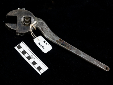
Tools, shifting spanner large c1930, c1930
An adjustable or shifting spanner or adjustable wrench is an open-end wrench with a movable jaw, allowing it to be used with different sizes of fastener head (nut, bolt, etc.) rather than just one fastener size, as with a conventional fixed spanner. Early settlers were self reliant and repaired their own equipment for kitchen,dairy, farm, horses, carts using various tools . This steel shifting spanner is typical of the type used by early settlers in Moorabbin Shire c1930A large heavy steel curved neck shifting spanner with adjustable screwFLAG BRAND / MADE IN GERMANYtools, spanners, shifting spanners, wrenches, early settlers, market gardeners, blacksmiths, tools, building equipment, hammers, moorabbin shire, bentleigh, mckinnon, highett, cheltenham,mcewan james pty ltd, melbourne, bunnings pty ltd, -
 Kew Historical Society Inc
Photograph - Flooding of the Yarra River in North Kew, 1934
North Kew, now divided between Kew and Kew East, bordered the Yarra River. As such, it was a region subject to flooding in the Yarra Valley. Development beyond this point (ie Kellett Grove) was limited by the City of Kew's planning regulations. Prior to urban development, the area since European settlement and the first land sales in the district in the 1840s, had been used for dairy farming. Small sepia snapshot taken from the river ramp of a house at 8 Kellett Grove, in what was then known as North Kew. The point of view is from a backyard looking towards Fairfield. Beyond the fence line are two almost submerged houses. A number of people are in a motor driven boat midstream. Fairfield at this period, (ie 1934) was noted for its limited river side development. Verso: 2/12/34 / TAKEN FROM OUR RAMPyarra river -- north kew, floods -- yarra valley, floods -- north kew, floods -- 1929, floods -- 1934, natural disasters -- kew -
 Kew Historical Society Inc
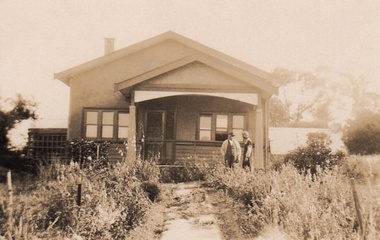
Photograph - 8 Kellett Grove, North Kew, 1929
North Kew, now divided between Kew and Kew East, bordered the Yarra River. As such, it was a region subject to flooding in the Yarra Valley. Development beyond this point (ie Kellett Grove) was limited by the City of Kew's planning regulations. Prior to urban development, the area since European settlement and the first land sales in the district in the 1840s, had been used for dairy farming. Small sepia snapshot taken of the front of 8 Kellett Grove, in what was then known as North Kew. Verso: 8 KELLETT GROVE / NORTH KEW / 1929 / 418 kellett gove -- north kew, californian bungalows, houses -- kellett grove -- kew (vic.) -
 Kew Historical Society Inc
Photograph - Flooding of the Yarra River in North Kew, 1934
North Kew, now divided between Kew and Kew East, bordered the Yarra River. As such, it was a region subject to flooding in the Yarra Valley. Development beyond this point (ie Kellett Grove) was limited by the City of Kew's planning regulations. Prior to urban development, the area since European settlement and the first land sales in the district in the 1840s, had been used for dairy farming. Small sepia snapshot taken from the back yard of a house at 8 Kellett Grove, in what was then known as North Kew. The point of view is from a backyard looking towards Fairfield. Floodwaters have submerged the fence and a clothes line. Verso: BACKYARD NTH. KEWyarra river -- north kew, floods -- yarra valley, floods -- north kew, floods -- 1934, natural disasters -- kew -
 Kew Historical Society Inc
Photograph - Flooding of the Yarra River in North Kew, 1934
North Kew, now divided between Kew and Kew East, bordered the Yarra River. As such, it was a region subject to flooding in the Yarra Valley. Development beyond this point (ie Kellett Grove) was limited by the City of Kew's planning regulations. Prior to urban development, the area since European settlement and the first land sales in the district in the 1840s, had been used for dairy farming. Small sepia snapshot taken from the back yard of a house at 8 Kellett Grove, in what was then known as North Kew. The point of view is from a backyard looking towards Fairfield. Verso: 8 KELLETT GROVEyarra river -- north kew, floods -- yarra valley, floods -- north kew, floods -- 1934, natural disasters -- kew -
 Kew Historical Society Inc
Photograph - Flooding of the Yarra River in North Kew, 1934
North Kew, now divided between Kew and Kew East, bordered the Yarra River. As such, it was a region subject to flooding in the Yarra Valley. Development beyond this point (ie Kellett Grove) was limited by the City of Kew's planning regulations. Prior to urban development, the area since European settlement and the first land sales in the district in the 1840s, had been used for dairy farming. Small sepia snapshot taken from the back yard of a house at 8 Kellett Grove, in what was then known as North Kew. The point of view is from a backyard looking towards Fairfield. Verso: OUR BACKYARD 8 KELLETT GROVEyarra river -- north kew, floods -- yarra valley, floods -- north kew, floods -- 1934, natural disasters -- kew -
 Kew Historical Society Inc
Photograph - View of the Yarra River from 8 Kellett Grove, North Kew, 1948
North Kew, now divided between Kew and Kew East, bordered the Yarra River. As such, it was a region subject to flooding in the Yarra Valley. Development beyond this point (ie Kellett Grove) was limited by the City of Kew's planning regulations. Prior to urban development, the area since European settlement and the first land sales in the district in the 1840s, had been used for dairy farming. The view from the rear of 8 Kellett Grove predates the construction of the Eastern Freeway so provides a rare view of the area before it was built.Small sepia snapshot taken from the back yard of a house at 8 Kellett Grove, in what was then known as North Kew. A tower of the Kew Asylum on the top left of the horizon assist the viewer to recognise that the land to the left of the river is in Kew and Studley Park.Verso: NORTH KEW 1948 / Stamped 51019yarra river -- north kew, kellett grove -- north kew -
 Kew Historical Society Inc
Photograph - Flooding of the Yarra River in North Kew, 1934
North Kew, now divided between Kew and Kew East, bordered the Yarra River. As such, it was a region subject to flooding in the Yarra Valley. Development beyond this point (ie Kellett Grove) was limited by the City of Kew's planning regulations. Prior to urban development, the area since European settlement and the first land sales in the district in the 1840s, had been used for dairy farming. Small sepia snapshot of floodwaters taken from near Kellett Grove, in what was then known as North Kew. The point of view is from a backyard looking towards Fairfield. In the foreground ar two men in a rowboat.Verso: OUR BACKYARD / Stamped 3 163yarra river -- north kew, floods -- yarra valley, floods -- north kew, floods -- 1934, natural disasters -- kew -
 Kew Historical Society Inc
Photograph - Flooding of the Yarra River in North Kew, 1934
North Kew, now divided between Kew and Kew East, bordered the Yarra River. As such, it was a region subject to flooding in the Yarra Valley. Development beyond this point (ie Kellett Grove) was limited by the City of Kew's planning regulations. Prior to urban development, the area since European settlement and the first land sales in the district in the 1840s, had been used for dairy farming. Small sepia snapshot of floodwaters taken from near Willsmere Road, in what was then known as North Kew. The point of view is looking towards Fairfield. In the foreground are two figures viewing a group in a rowboat in the middle of the flooded river. Semi-submerged street lighting indicates that entire streets had been. overwhelmed by the flood waters. Verso: WILLSMERE ROAD NORTH KEW / Stamped 3 163yarra river -- north kew, floods -- yarra valley, floods -- north kew, floods -- 1934, natural disasters -- kew, willsmere road -
 Kew Historical Society Inc
Photograph - Flooding of the Yarra River in North Kew, 1934
North Kew, now divided between Kew and Kew East, bordered the Yarra River. As such, it was a region subject to flooding in the Yarra Valley. Development beyond this point (ie Kellett Grove) was limited by the City of Kew's planning regulations. Prior to urban development, the area since European settlement and the first land sales in the district in the 1840s, had been used for dairy farming. Small sepia snapshot of floodwaters in North Kew. The point of view is of two houses belonging to local families that were surrounded by floodwater. Verso: HYATTS HOUSE / WILLSMERE ROAD / Stamped 3 163yarra river -- north kew, floods -- yarra valley, floods -- north kew, floods -- 1934, natural disasters -- kew, willsmere road -
 Kew Historical Society Inc
Photograph - Flooding of the Yarra River in North Kew, 1934
North Kew, now divided between Kew and Kew East, bordered the Yarra River. As such, it was a region subject to flooding in the Yarra Valley. Development beyond this point (ie Kellett Grove) was limited by the City of Kew's planning regulations. Prior to urban development, the area since European settlement and the first land sales in the district in the 1840s, had been used for dairy farming. Small sepia snapshot of floodwaters in North Kew, from the rear of 8 Kellett Grove. Verso: OUR BACKYARD / Stamped 52yarra river -- north kew, floods -- yarra valley, floods -- north kew, floods -- 1934, natural disasters -- kew, willsmere road