Showing 3425 items
matching distance
-
 Lakes Entrance Historical Society
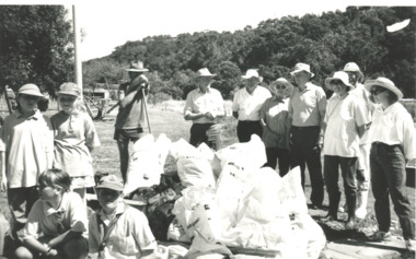
Photograph, Lakes Post Newspaper, North Arm foreshore, Lakes Entrance Victoria, 1/03/1995 12:00:00 AM
Black and white photograph of eight adults and four children with bags of rubbish collected from North Arm foreshore, Jennifer North identified. North Arm bridge in distance. Lakes Entrance Victoriaenvironment, people -
 Lakes Entrance Historical Society
Photograph - Lake Tyers, 1920 c
Black and white photograph of Lake Tyers taken from Aboriginal Station showing island in lake and entrance in distance with animal hides drying along the fence sheep and cattle Lake Tyers Victoriawaterways -
 Kew Historical Society Inc
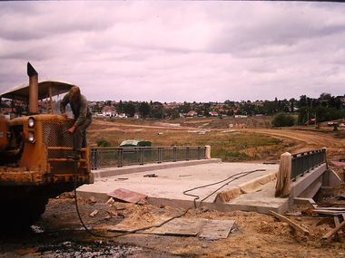
Photograph - Construction of the Eastern Freeway (F19), Ron Setford, November 1971
Ron Setford and his wife Grace Setford lived in Tanner Avenue, East Kew, from c.1946 to c.1995. A keen photographer, he recorded the changing face of Kew over a 20 year period. Apart from 30 photographs of built structures and places in Kew dating from 1960 and 1961, 145 of his 35mm colour slides chronicle the development of the F19 (later renamed Eastern) Freeway through the Yarra Valley in Kew over a five year period from c.1972 to c.1977. This important collection was donated to the Society by his granddaughter in 2025.This collection of 175 35mm slides is of local and statewide significance, owing to its subject matter, particularly the major development of road transport infrastructure during the 1970s with the construction of the Eastern Freeway. The photographer also took care to annotate and date most of his slides which enable the researcher to pinpoint temporal and spatial locations.Earth moving vehicle at the beginning of construction of the Eastern (F19) Freeway in 1971 with a temporary concrete bridge near Chandler Highway. In the distance, the ESSO Service Station at the bottom Princess Street can be seen"Eastern Freeway / Temporary Bge / Chandler Hwy / Nov 71"ron setford, eastern freeway, f19 freeway -
 Geoffrey Kaye Museum of Anaesthetic History
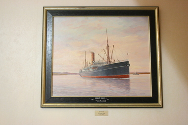
Painting, Ib Odfeldt, S.S. Ulimaroa
Dr Bernie Dunn spotted a model of the merchant ship 'Ulimaroa' at Pollywoodside Museum after which he commissioned Ib Odfeldt, a Danish prize winning marine artist, to depict the vessel at sea.The painting was later gifted to ANZCA in 2006. John Traill, co-owner of Huddart Parker Ltd, named the ship in 1907 after his family home 'Ulimaroa' the building which was later purchased by the newly established ANZCA. The S S Ulimaroa was one of the popular ships in the Huddart Parker fleet that was in regular service between Australia and New Zealand from 1908 to 1934. This service was interrupted by WWI when it was commissioned by the NZ Government to carry troops. During the depression it was de-commissioned where it lay in Sydney Harbor until 1934 when it sailed under its own steam to Japan to be converted into scrap metal. Oil on board painting of the merchant ship S S Ulimaroa on the Derwent River, Hobart, with landscape in distance and small steam boat on of main ship. Set in a plain gold and black wooden frame.[on frame in white ink] HUDDART PARKER LTD. / 1908 1934 / S/S ULIMAROA [on reverse in black ink] THIS PAINTING WAS COMMISSIONED / BY DR BERNARD L. DUNN & WIFE JEAN. / FOR THE ANZ COLLEGE OF ANESTHETIST 2006 ("ULIMAROA" ST KILDA RD MELBOURNE ) / TITLE: ULIMAROA ON THE DERWENT RIVER, (TASMANIA) / ARTIST IB ODFELDT / MEDIUM: OIL ON BOARD 2006 / THE SMALL STEAMER IN THE BACKGROUND S/S WARRENTINA / 808 CYGNET COAST RD / PETCHEY'S BAY 7109 TAS. / RED STAMP dunn, bernard, ulimaroa, odfeldt, ib, parker, huddart, traill, john -
 Greensborough Historical Society
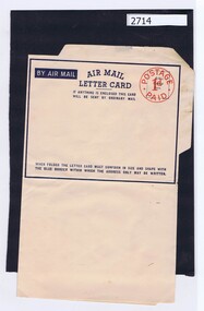
Card, Air Mail Letter card, 1930s
An example of an Air Mail Letter Card (cost 1 penny), used for cheap mail over long distances.Printed in blue on white paper, two gummed edges to seal envelope when folded. "Postage paid 1d."postage, air mail, black family -
 Eltham District Historical Society Inc
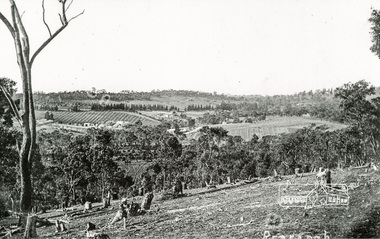
Photograph, Tom Prior, Clearing land at Research
Main Road is in the distance with the aqueduct following the pine trees at top of photo. Doney's store is visible near the road.The Reynolds family were early settlers in Research. The Reynolds/ Prior collection of photographs were taken by Tom Prior, the maternal uncle of Ivy Reynolds, around 1900 and the 60 photos in the album give a fine overview of many of the landmarks of Research and Eltham over 100 years ago. lvy lived in the family home for many years at 106 Thompson Cres Research. Ivy's father, Ernst Richard Reynolds and grandfather, Richard Reynolds, lived at the same address. Ivy's father Richard worked for Mr. Trail on his property in Research. Reynolds Road is named after the family. Mr Tom Prior (wife Eva) worked at the Melbourne zoo. He was very innovative and made his own camera, using the black cloth hood to exclude the light. The photographs are a reminder of the rural nature of Research and Eltham and its rich heritage. Black and white photograph mounted in an album, the Reynolds/Prior Photograph Collection, this being one of 53 reproduced black and white images of early Eltham.The Reynolds/Prior Photograph Collection, Presented to the Eltham District Historical Society, 14 June 2006 by Ross McDonald. A second copy was also presented to the Andrew Ross Museum, Kangaroo Groundreynolds prior collection, research (vic.) -
 Royal Australian and New Zealand College of Obstetricians & Gynaecologists (RANZCOG)
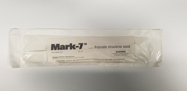
Equipment - Mark-7 disposable uterine sound associated with Dr Lachlan Hardy-Wilson, Searle Laboratories, 1984
Used to measure the depth/distance of the uterus. Uterine sounds are particularly useful for ensuring safe and accurate IUD placement.This is one of a collection of items received from the practice of Dr Lachlan Hardy-Wilson, FRCOG, Launceston, Tasmania.Disposable uterine sound in sterile sealed packaging. Label inside packaging reads 'Mark-7 brand of disposable uterine sound/ONE STERILE UNIT/NO. 154'. Label also includes manufacturer information, a sterile packaging warning, and a caution about sale of the item being restricted to physicians.intrauterine device -
 Mt Dandenong & District Historical Society Inc.
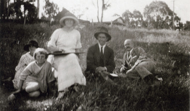
Photograph, Visitors Picnicking in the Vicinity of Mountjoy c1920, c1920
An unnamed group comprising a woman , two men and two girls sitting in the grass with Mountjoy Guest-house in the distance.Black and white blurred photograph showing a woman, two men and two children sitting in the grass below a building.guest house, mountjoy -
Ballarat Tramway Museum
Photograph - Geelong Tramway laying of Malop St. tracks
Tram tracks being laid in Malkoip Street, looking SW, 1911. Several of the buildings in the distance still stand.Black and white print on paper.GSR710/25/1/1 and 25-1 written in pencil on the reverse. The No. 1 in a circle is written in pen on the reverse.geelong tramways new tracks, geelong streetscape c. 1911 -
 Kiewa Valley Historical Society
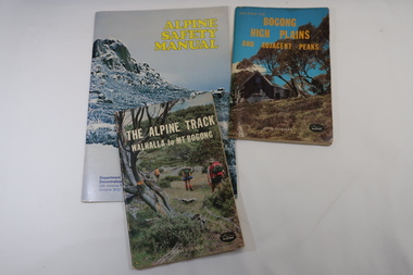
Books x3 - Walking on the Bogong High Plains, 1. The Alpine Track Walhalla to Mt Bogong. 2. Bogong High Plains and Adjacent Peaks both by John Siseman 3. Alpine Safety Manual
Books were published to guide walkers travelling long distances in remote areas increasing their safety and giving them independence.Bogong High Plains and Mt Bogong are at the upper end of the Kiewa Valley where local people and visitors spend their leisure time, walking.1. and 2. both written by John Siseman, small (pocket size), includes maps and black & white photos. The covers are colored photos with the title at the top. 1. has 78 pages and 2. has 63 pages.The Alpine Safety Manual (in yellow) is twice the size of the others and published by the Department of State Development, Decentralization and Tourism.It has 40 pages, coloured and black & white photos and is held by 2 staples.bush walking, bogong high plais, walhalla to mt bogong, alpine track -
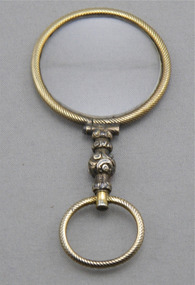 The Cyril Kett Optometry Museum
Round gold rimmed quizzer, 19th Century
The power of the lens, +7.50 DS, suggests this might be a magnifying lens for near work rather than a quizzer for distance vision.Round gold rimmed quizzer with machine engraved lens rim. Turned ornamental stem with a small engraved swivelling ring at its end for a cord or ribbon. The lens is glass of power of +7.50 DS. -
Lakes Entrance Historical Society
Photograph - Buchan Flats, 1/09/1933 12:00:00 AM
Also three other similar photographs taken at same time 05197.1 showing cave house in distance. and 05197.2 and .3Black and white photograph showing view of Buchan flats from Gelantipy Road with children June and Rex Fish standing by fence Buchan Victoria -
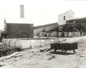 Bendigo Historical Society Inc.
Photograph - DEEBLE'S PYRITES WORKS, approx. 1950's
black and white photo - enlargement - of Deeble's Pyrites Works. Concrete vats near foregound and middle distance, elevatged building in background,. Two male adults at left middle distance. Carboys ( acid ) planks, tall weatherboard building and brick decorated chimney towards RH side of image. On back in grey lead 'Deebles Pyrites Works/1889. James Lerks identified this as being Spargo's Pyrites - the picture appears in 'Bendigo's Gold Story' by Ralph W Birrell and James A Lerk.cottage, miners -
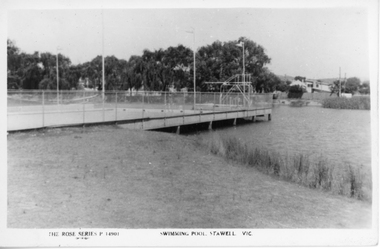 Stawell Historical Society Inc
Photograph, Cato Lake with the Swimming Pool c 1950's
Two black and white post cards of the Olympic swimming pool in Cato lake c 1950's. The Rose Series P 14901 shows the swimming pool and lake with the swimming pool dominating the photograph. Four flag posts are clearly visible and the pool connected to the edge of the lake. The Rose Series P 14012 also shows the Olympic pool but more of the lake and boundary. with seating around the lake. In March 1957 Cato Lake was emptied for construction of the Olympic pool and officially opened on 15.11.1958. Twenty seven years later In January 1985 the pool was found to be leaking and Borough Council in February banned further use of the Olympic pool. Eventually the Olympic pool was demolished in April 1988.Two black & white Rose series post cards of Cato Olympic swimming pool Stawell Vic. c 1950's. Series P 14901 is nearly a complete view of the Olympic pool with four flag posts in view and trees and buildings in the distance. Series P 14012 has only a small section of the Olympic pool in the photograph with just 3 flag poles in view. There are 2 concrete and timber seats in the foreground and Cato lake is very still, reflecting the distance trees.The Rose Series P 14901 Swimming Pool Stawell Vic. and The Rose Series P 14912 Cato Park and swimming pool Stawell, Vic. Both post cards were Published by Rose Stereograph Co., Armadale, Victoria. The "Rose" series De Luxe.stawell -
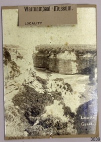 Flagstaff Hill Maritime Museum and Village
Photograph
HISTORY OF THE LOCH ARD The LOCH ARD belonged to the famous Loch Line which sailed many ships from England to Australia. Built in Glasgow by Barclay, Curdle and Co. in 1873, the LOCH ARD was a three-masted square rigged iron sailing ship. The ship measured 262ft 7" (79.87m) in length, 38ft (11.58m) in width, 23ft (7m) in depth and had a gross tonnage of 1693 tons. The LOCH ARD's main mast measured a massive 150ft (45.7m) in height. LOCH ARD made three trips to Australia and one trip to Calcutta before its final voyage. LOCH ARD left England on March 2, 1878, under the command of Captain Gibbs, a newly married, 29 year old. She was bound for Melbourne with a crew of 37, plus 17 passengers and a load of cargo. The general cargo reflected the affluence of Melbourne at the time. On board were straw hats, umbrella, perfumes, clay pipes, pianos, clocks, confectionary, linen and candles, as well as a heavier load of railway irons, cement, lead and copper. There were items included that intended for display in the Melbourne International Exhibition in 1880. The voyage to Port Phillip was long but uneventful. At 3am on June 1, 1878, Captain Gibbs was expecting to see land and the passengers were becoming excited as they prepared to view their new homeland in the early morning. But LOCH ARD was running into a fog which greatly reduced visibility. Captain Gibbs was becoming anxious as there was no sign of land or the Cape Otway lighthouse. At 4am the fog lifted. A man aloft announced that he could see breakers. The sheer cliffs of Victoria's west coast came into view, and Captain Gibbs realised that the ship was much closer to them than expected. He ordered as much sail to be set as time would permit and then attempted to steer the vessel out to sea. On coming head on into the wind, the ship lost momentum, the sails fell limp and LOCH ARD's bow swung back. Gibbs then ordered the anchors to be released in an attempt to hold its position. The anchors sank some 50 fathoms - but did not hold. By this time LOCH ARD was among the breakers and the tall cliffs of Mutton Bird Island rose behind the ship. Just half a mile from the coast, the ship's bow was suddenly pulled around by the anchor. The captain tried to tack out to sea, but the ship struck a reef at the base of Mutton Bird Island, near Port Campbell. Waves broke over the ship and the top deck was loosened from the hull. The masts and rigging came crashing down knocking passengers and crew overboard. When a lifeboat was finally launched, it crashed into the side of LOCH ARD and capsized. Tom Pearce, who had launched the boat, managed to cling to its overturned hull and shelter beneath it. He drifted out to sea and then on the flood tide came into what is now known as LOCH ARD Gorge. He swam to shore, bruised and dazed, and found a cave in which to shelter. Some of the crew stayed below deck to shelter from the falling rigging but drowned when the ship slipped off the reef into deeper water. Eva Carmichael had raced onto deck to find out what was happening only to be confronted by towering cliffs looming above the stricken ship. In all the chaos, Captain Gibbs grabbed Eva and said, "If you are saved Eva, let my dear wife know that I died like a sailor". That was the last Eva Carmichael saw of the captain. She was swept off the ship by a huge wave. Eva saw Tom Pearce on a small rocky beach and yelled to attract his attention. He dived in and swam to the exhausted woman and dragged her to shore. He took her to the cave and broke open case of brandy which had washed up on the beach. He opened a bottle to revive the unconscious woman. A few hours later Tom scaled a cliff in search of help. He followed hoof prints and came by chance upon two men from nearby Glenample Station three and a half miles away. In a state of exhaustion, he told the men of the tragedy. Tom returned to the gorge while the two men rode back to the station to get help. By the time they reached LOCH ARD Gorge, it was cold and dark. The two shipwreck survivors were taken to Glenample Station to recover. Eva stayed at the station for six weeks before returning to Ireland, this time by steamship. In Melbourne, Tom Pearce received a hero's welcome. He was presented with the first gold medal of the Royal Humane Society of Victoria and a £1000 cheque from the Victorian Government. Concerts were performed to honour the young man's bravery and to raise money for those who lost family in the LOCH ARD disaster. Of the 54 crew members and passengers on board, only two survived: the apprentice, Tom Pearce and the young woman passenger, Eva Carmichael, who lost all of her family in the tragedy. Ten days after the LOCH ARD tragedy, salvage rights to the wreck were sold at auction for £2,120. Cargo valued at £3,000 was salvaged and placed on the beach, but most washed back into the sea when another storm developed. The wreck of LOCH ARD still lies at the base of Mutton Bird Island. Much of the cargo has now been salvaged and some was washed up into what is now known as LOCH ARD Gorge. Cargo and artefacts have also been illegally salvaged over many years before protective legislation was introduced. One of the most unlikely pieces of cargo to have survived the shipwreck was a Minton porcelain peacock - one of only nine in the world. The peacock was destined for the Melbourne International Exhibition in 1880. It had been well packed, which gave it adequate protection during the violent storm. Today, the Minton peacock can be seen at the Flagstaff Hill Maritime Museum in Warrnambool. From Australia's most dramatic shipwreck it has now become Australia's most valuable shipwreck artefact and is one of very few 'objects' on the Victorian State Heritage Register. Flagstaff Hill’s collection of artefacts from LOCH ARD is significant for being one of the largest collections of artefacts from this shipwreck in Victoria. It is significant for its association with the shipwreck, which is on the Victorian Heritage Register (VHR S417). The collection is significant because of the relationship between the objects, as together they have a high potential to interpret the story of the LOCH ARD. The LOCH ARD collection is archaeologically significant as the remains of a large international passenger and cargo ship. The LOCH ARD collection is historically significant for representing aspects of Victoria’s shipping history and its potential to interpret sub-theme 1.5 of Victoria’s Framework of Historical Themes (living with natural processes). The collection is also historically significant for its association with the LOCH ARD, which was one of the worst and best known shipwrecks in Victoria’s history. Photograph of Loch Ard Gorge. Photograph taken some distance from the Gorge. Three men in the Gorge and outlines of steps can be seen. Right hand side of the photograph is written "Loch Ard Gorge"flagstaff hill, warrnambool, shipwrecked coast, flagstaff hill maritime museum, maritime museum, shipwreck coast, flagstaff hill maritime village, great ocean road, loch line, loch ard, captain gibbs, eva carmichael, tom pearce, glenample station, mutton bird island, loch ard gorge, photograph of loch ard gorge, photograph -
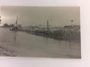 Port of Echuca
A black and white photograph, 24/09/1984
This is a copy of a photograph from the Price Collection. The river and town are unknown. The photograph shows how locks were constructed using long vertical planks to form a wall. One of the cranes is floating on a pontoon.This shows how the river was locked to develop the irrigation industry in the early 20th Century.A copy of a black and white rectangular photograph of a lock being constructed . The river is in the foreground and in the background, cranes and rigs can be seen. A wooden wall dominates the centre of the photograph. Houses and buildings can be seen in the distance.In pencil on the back is written; 'Price / Lock construction? 'Jenkins Print Mildura.'lock construction, price family collection, mildura, jenkins print, irrigation -
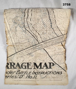 Bendigo Military Museum
Map - TRENCH MAP WW1, Possibly 1918
Villeret is centred within the areas of Rosiel, Bony, Bellicourt and Bellenglise. The map is possibly when the advance was into the Hindenburg Line in late 1918. Item re William Alexander No 502 AIF. Refer Cat No 3746.3 for his service details.Map, small section of a “Barrage map” showing objective lines with distances, enemy trenches are in blue. Top half and bottom half of the map are missing. Area covered appears to be “Villeret” scale 1:20,000map, trench, barrage -
Glenelg Shire Council Cultural Collection
Accessory - Sash, n.d
The Ancient Order of Foresters, which originated in England in the mid 1700s, established its first branch (Court) in Victoria in 1849. Foresters was set up as a non-profit organisation, the founding principles of the Society being to provide financial and social benefits as well as support to members and their families in times of unemployment, sickness, death, disability and old age. The Society is now known as the Foresters Friendly Society and in July 1999 was incorporated as a public company limited by shares and guarantee.Plain gold sash, silk, 6 cm red fringe on each short end. 2 remains of red ribbon attached to one long side, each piece a similar distance from endsancient order of foresters, friendly society, societies -
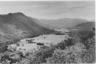 Halls Gap & Grampians Historical Society
Photograph, C 1940 -50s
Valley is now known as Fyans Valley but in the 1840-50s it was called Lady Mary's Vale. See p. 111 of 'Victoria's Wonderland' for historical information.A valley with a cleared area stretching along the valley floor. A mountain range runs along the left and into the distance of the photograph. a rocky outcrop, bushes and trees appear in the front and right of the photo. c 1940-1950sscenery, fyans valley -
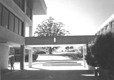 Federation University Historical Collection
Photograph - Black and White, Mount Helen Campus view of the Big Tree from the Library
Black and white image of the walkway between the E.J. Barker Library (L Building) and E Building. The tree in the distance is the tree of Knowledge, and the small wall near the walkway is a pond which has been removed. mount helen, mount helen campus, tree of knowledge, walkway, library, pond -
Glenelg Shire Council Cultural Collection
Photograph - Photograph - Lee Breakwater, n.d
Port of Portland Authority Archivesport of portland archives -
 Bendigo Historical Society Inc.
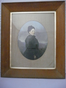
Photograph - PORTRAIT OF A LADY, c-1900
Coloured portrait of a lady standing. In a black dress and a black hat, black hair. Hills in distance, tree at side front, blue sky. Oval frame around portrait. DR 285 Deframed 2022person, individual, portrait female -
Tatura Irrigation & Wartime Camps Museum
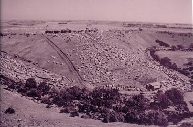
Photograph, Big Eildon Under Construction, 1954
Taken by photographer for State Rivers and Water Supply Commission. Taken at Mount SugarloafLarge sepia photograph. Rocks and uprooted trees in foreground, temporary wooden huts and truck, middle distance terraced earthen dam wall, left of wall water dammed back rounded hills beyond.Bottom edge of photo: "State Rivers and Water Supply Commission / BIG EILDON UNDER CONSTRUCTION."victoria state rivers and water supply commission, eildon, eildon dam -
Tatura Irrigation & Wartime Camps Museum
Photograph, Eildon Township, 1957
Taken by photographer for State Rivers and Water Supply Commission.Medium sized black and white photo. Aerial photograph - looking down on township in middle foreground - overflow dam to the right, middle distance - dam wall with reservoir beyond - mountain tops forming horizonOn frame below photo: "Eildon Township."victoria state rivers and water supply commission, eildon -
 Hume City Civic Collection
Photograph
A photocopied image of an Aboriginal midden. A man is standing to the left of the photograph in the hollow and a dog is standing on the edge of the hollow. There are a few trees in the middle distance and bare hills along the skyline. Framed in mustard coloured board.aboriginal culture, aborigines, middens, aboriginal reserves, george evans collection -
 Hume City Civic Collection
Photograph, 1972
The photograph was taken during the 1972 Sunbury Pop Festival which was staged on a property owned by George Duncan. The site is on the banks of the Jacksons Creek between Sunbury and Diggers Rest.An aerial photograph of a crowd of people on a hillside and along a creek valley with a stage set up. On the LHS there is a large marquee surrounded by cars and pitched tents. There are trees around the creek and vast open paddocks in the distance.sunbury pop festival, jacksons creek, duncan, george, george evans collection -
 Surrey Hills Historical Society Collection
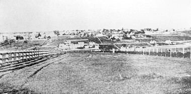
Photograph, Looking towards Box Hill from the site of the Surrey Hills Golf Club, 1902, 1902
Reproduced by permission of Mr John Arnold from his book: "The Riversdale Golf Club - a history, 1892-1977." Copyright to book: Riversdale Golf Club. Surrey Hills Golf Club operated from 1892-1908 then moved and became Riversdale Golf Club. The game was played across paddocks from Trafalgar Street, Mont Albert to Whitehorse Road and down Victoria Crescent to where Box Hill TAFE is now located in Elgar Road. There were problems with cows eating the tee flags! The clubhouse still exists as 30 Trafalgar Street.Black and white photo with a large grassy paddock in the foreground. From the bottom left and right post-and-rail fences converge on a group of large industrial buildings in the centre middle distance. In the background are paddocks and buildings."Top: Looking towards Box Hill from the links in 1902. The old Box Hill Gas Works is in the centre of the picture."sports grounds, surrey hills golf club, riversdale golf club, box hill gas works, gasworks, public utilities, gas -
 Melton City Libraries
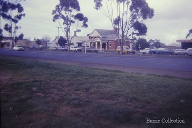
Photograph, High Street, Melton, 1969
View of High Street with the Police Station [House] and Court House in the background. Small house in McKenzie street on right in the distance. Land vacant prior to construction of Supermarket. Small house at the rear of Police Station. emergency services, local architecture -
 Coal Creek Community Park & Museum
Equipment - Powder folder
Used by Manning Chemist, Flinders Street Railway Station, Melbourne for folding individual powder portions into paper packages until 1984. Brass 'x' shaped folding frame with centre axle. There are indentations down one leg where the swivel pin is placeed to adjust height and to hold the two sloped top panels at varying distance apart. Marked on top plate: British Made. -
 Lakes Entrance Historical Society
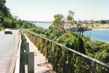
Photograph - Princes Highway Lakes Entrance, 1990 c
One other photograph showing vegetation taken from the left hand side of road.Colour photograph taken from the Princes Highway, showing the last bend in the road before the northern approach to the concrete North Arm Bridge, shows the North Arm and waterfront in distance. Lakes Entrance Victoria bridges, roads and streets, township