Showing 2630 items
matching government of australia
-
 Bendigo Military Museum
Administrative record - LEAVE PASSES WW2, Government Printer, c.1940 onwards
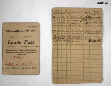
J.H Hicks, refer cat No 1363 for service details.Two Leave Passes, cream coloured cardboard with black print.Printed in black on front: “Form P/P26 Royal Australian Air Force Leave Pass Leave for the period & destination shown on the inside of this pass is granted to” In red handwriting: “51964 LAC HICKS J H” Printed in black: Whose signature appears on back On back: Unit Stamp to be Impressed hereunder No 2 OPERATIONAL TRAINING UNIT ROYAL AUSTRALIAN AIR FORCE Signature of Airman to whom this Pass is issued LEAVE GRANTED from standdown until 2359 hours daily except Mondayadministrative, leave, raaf -
 Bendigo Military Museum
Badge - BADGE, REMEMBER IRAQ, c.2006
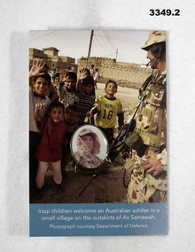
In March 2003 military forces of the Coalition of the Willing, including 2,000 men & women of the Australian Defence Force (ADF) invaded Iraq. Since July 2003 working with the interim Iraqi Government, the ADF has continued to contribute to Multinational Force efforts to develop a secure & stable environment in Iraq & assist national recovery programs. In mid Jun 2005 some 1,400 ADF personnel were serving in Iraq.Small enamel badge showing face of a soldier which is attached in the centre of cardboard. Cardboard shows coloured print of children welcoming an Australian soldier.Printed on badge: “Remember Iraq” Printed bottom of cardboard: “Iraqi children welcome an Australian soldier in a small village on the outskirts of As Samawah. Photograph courtesy of Department of Defence” Printed back of cardboard: “Remember Iraq”badge, iraq, 2003 -
 Bendigo Military Museum
Administrative record - COMPENDIUM WW1 - WW2, 4) A H Pettifer, Government Printer et al, 2) 14.2.1946; .3) 1.3.1919; .4) 30.11.1954 .5) 24.11.19? - WWI; .6) 31.10.1917; .7) 12.6.1917; .8) Page 1: 20.12.1915, Page 2: 10.12.1915, Page 6: 19.1915; .9) 10.9.1918; .10) 18.4.1919; .11) c.2.3.19?; .12) 18.9.1920; .14) post WWI; .15) 24.4.1920; .17) 18.4.1942; .18) 19.6.1943; .19) 18.3.1947; .20) 1944; .21) 1944; .23) 22.10.1941; .26) 13.9.1944; .27) 1.1944; .30) 7.3.1950; .31) 31.7.1944; .32) 16.4.1942; .33) 13.6.1946; .34) 6.5.1946; .36) a) & b) 3.11.1947; .37) 24.10.1951; .38) 24.9.1957; .39) 9.10.1957; .40) 19.2.1958; .41) 26.2.1958; .42) 1.3.1958; .43) & .44) 7.3.1958; .45) 25.2.1958; .46) 3.1.1948; .47) 26.2.1948; .48) 22.4.1958; .49) 24.2.1958; .50) 12.3.1958; .51) 6.1958; .52) c.Mar/Apr 1958; .53) 5.4.1958; .54) c.end WWII; .55) a.b. 13.6.1967; .56) 26.5.1967; .57) 18.2.1954
Herbert Trangmar Allan, refer 2755.4 for his extensive service history and wards. .2) Details gifting of a pair of Japanese binoculars to Col H T ALLAN by Pacific Island Regiment. .3) Certificate issued by Winston Churchill, Secretary of State for War (The War of 1914-1918), awarded to Capt H T ALLAN MC. .4) Herbert Trangman ALLAN born 5.1.1895 at Woolwich, NSW. Middle name misspelled, should be Trangmar not Trangman. .6) Congratulating H T ALLAN on receiving the Military Cross award for leading 2 companies which had lost officers during action on Passchendaele Ridge on 9.10.1917. .7) Describes life behind the lines whilst H T ALLAN's battalion has been resting for a month. Daily life consisted of training drills, sport & entertainment. Writer takes time to describe the countryside & weather. .8) Relate to H T ALLAN's military exam results & his promotion to 2nd Lieutenant in 1915. .9) To Herbert Allan's father, Mr P Allan detailing the citation for awarding of the Military Cross to Herbert ALLAN. Original citation appeared in the London Gazette,5.4.1918. .10) Form addressed to Capt H ALLAN MC, 17th Battalion stating his period of enlistment in the 1st AIF was to expire 26.5.1919. .11) Letter from Lord BIRDWOOD (General) to Herbert ALLAN in response to a letter received 19.11.19?. General BIRDWOOD expresses his opinions on difficulties the allied troops face in their fight against the Japanese. .12) Letter to Capt H T ALLAN advising of MID oak leaves sent to him. Details guidelines for attaching oak leaves to both the larger Victory Medal & the small service dress medal. .13) Form details H T ALLAN's WWII Army No, Rank, Unit & Decorations & Medals held. The form has not been signed & dated. .14) Details service record of Lt Col H T ALLAN NX12229. Includes military service from 1912 - 1944, schools & courses attended, decorations, promotions & overseas service. .16) Form issued to H T ALLAN on 15.12.1939 granting permission to leave New Guinea for Australia & return within a period of 12 months. Issued by Customs Office in Salamaua. Lists H T ALLAN's age as 44, height 5' 10" & occupation. .17) Letter from Major General MORSHEAD GOC, AIF (ME) to Major H T ALLAN, OBE, MC congratulating him on being awarded the OBE for outstanding service at Tobruch. .18) Letter from Major General MORSHEAD to Major H T ALLAN, OBE, MC replying to ALLAN's letter of 15.6.1943. MORSHEAD is congratulating ALLAN on his appointment to New Guinea Force, also acknowledges his excellent service record. .19) Letter acknowledges H T ALLAN's resignation from the Office of Production Member of the Australian New Guinea Production Control Board, effective from 28.8.1946. .20) Major General WINDEYER commanded the 20th Brigade from 1942-1946. .22) Card sent from the CO of the 3rd Australian Anti-Tank Regiment. .23) Menu for Farewell Dinner held in the Officer's Mess of the 20th Infantry Brigade, Tobruch on 22.10.1941. .24) Menu & Toast list for Farewell Dinner to Brigadier J J MURRAY DSO MC VD. Attended by H T ALLAN & held in the Officers Mess, 2/17 Australian Infantry Battalion on 22.12.1941. .25) Invitation to Col H T ALLAN by Lady Gowrie (wife of Governor General Baron Gowrie) to attend a Luncheon at Government House, Canberra, ACT. .26) Letter to Major (T/Lt Col) H T ALLAN from Major W A JENNER advising him of his secondment to 2/17 Australian Infantry Battalion & appointment to command 5 Aust Base Sub Area. .27) Application for Africa Star with Eighth Army Clasp signed by H T ALLAN & approved by Lt Colonel of 2/17 Australian Infantry Battalion. H T ALLAN held the rank of Major (substantive) at the time of qualification, 1.3.1942 - 11.1942. He held the rank of Lt Colonel at the time of application in 2.1944. .28) Detailing changes in command & promotions including that of Lt Col H T ALLAN, dated 1.4.19? .29) For Lt Col H T ALLAN detailing movements required by First Australian Army command. .30) Acknowledgement & confirmation of Col H T ALLAN's application for campaign awards for WWII. .31) Letter addressed to Lt Col H T ALLAN from Lt Gen Stanley Sauige requesting information on New Britain for a forthcoming visit. .32) Certificate was presented to H T ALLAN on 16.4.1942 when he was awarded an OBE by King George VI. .33) Document details H T ALLAN's relinguishing of Command of the HQ of Pacific Islands Regiment. ALLAN also relinguished the rank of temporary Colonel & was transferred to the Reserve of Officers with rank of substantive Lt Colonel. .35) Official letter to Colonel H T ALLAN from Joseph Francis, Minister for the Army. The letter acknowledges Col ALLAN's long & distinguished career during both peace & wartime. .36) a) & b) From H T ALLAN (assumed) to Prime Minister J B CHIFFLEY referring to the production of copra in New Guinea, the actions of the Commonwealth Bank in relation to planters & the collaboration of New Guinea natives with the Japanese. Assumed to be a copy of original. .37) Letter to H T ALLAN indicating he had been placed on the Retired List with the rank of Honorary Colonel. .38) Letter invites H T ALLAN to officially open the State Conference in Lae in late March or early April 1958. Invitation was extended due to H T ALLAN for distinguished service in PNG. .39) Letter to H T ALLAN thanking him for accepting the invitation to open the Papua & New Guinea State Conference in late March or early April 1958. .40) Letter from H T ALLAN to Lt Gen Sir Henry WELLS, Chief of the General Staff, Victoria Barracks, Melbourne. ALLAN requests permission to wear his uniform for official engagements during his upcoming visit to New Guinea. ALLAN also offers advice on how to deal with native troops including serving time with them, learning their language & studying their customs. He suggests that this would help quell & dissent & revolt. .41) Reply from Major General DALY to HT ALLAN thanking him for his offer to spend time with the CO of the Pacific Island Regiment to address concerns with that unit. This meeting would coincide with ALLAN's upcoming visit to PNG. .42) HT ALLAN's reply to Major General T J DALY's letter of 26.2.1958. ALLAN requests an opportunity to discuss PIR issues with Major General DALY prior to his visit to PNG. .43) Major General T J DALY's reply to HT ALLAN's request for a meeting to discuss ongoing issues with the Pacific Island Regiment. .44) Letter from HT ALLAN to Brigadier D M CLELAND notifying him that he will be staying in Port Moresby on his way to the RSS&AILA Congress in Lae. .45) Lieutenant Colonel MCGUINN writes to invite Colonel ALLAN to visit the PIR during his visit to New Guinea at the end of March of the beginning of April 1959. .46) Letter of appreciation to H T ALLAN thanking him for his efforts in presenting the case for the Territory of New Guinea during the post WWII transition period. .47) Letter to H T ALLAN from New Guinea Citizens Association, Lae Branch, thanking him for his service on behalf of the people of the Territory of New Guinea. The association offered to send ALLAN a suitable present in recognition of his service. .48) Major General T J DALY's reply to HT ALLAN's suggestions for handling disquiet amongst the native troops in the Pacific Island Regiment. .49) Reply from Lieutenant General WELLS to H T ALLAN granting him permission to wear his uniform on his forthcoming visit to New Guinea. WELLS also notes that he has passed other requests made by ALLAN to Major General DALY. .50) Copy of H T ALLAN's reply to Lieutenant General WELL's letter of 24.2.1958 [.49)]. .51) A written account of Colonel H T Blue ALLAN's visit to New Guinea in 3.1958. Article appeared on p.65 & 67 of the 6.1958 edition of Pacific Islands Monthly. .52) Newspaper account of Colonel H T Blue ALLAN's opening of the Rabaul Branch of the Native Ex Servicemen's Association. Colonel ALLAN spoke of the involvement of the Pacific Islands Regiment during WWII. .53) The Rabaul Times account of Colonel H T Blue ALLAN's opening of the Rabaul Branch of Native Ex Servicemen's Club. Featured on p1, concluded p3. .54) Biographical account of Colonel H T ALLAN's service in WWI & WWII. In addition an account of his success in New Guinea between the wars is included. .55) a.b. Biography of Colonel H T ALLAN written by R W Robson who was the founder of the Pacific Islands Monthly. Article was written following ALLAN's death on 23.5.1967 aged 72. This item is a pre publication copy of Robson's article which appeared in the Pacific Islands Monthly. .56) Text of a valedictory given at the funeral of Colonel Herbert Trangmar ALLAN OBE, MC, ED, NX12229 held 26.5.1967 following his death on 23.5.1967. The speech summarized his life in both wars & civilian life. 57) Invitation issued to Colonel H T & Mrs ALLAN to attend a Garden Party at Government House on 18.2.1954. At this function Colonel H T & Mrs ALLAN were to be presented to her Majesty Queen Elizabeth II.Herbert T ALLAN Collection. The contents are all of various size, the Album is the size documented. .1) Large teal green album containing 16 plastic pockets each with white card insert. Various documents & photos contained in each pocket. .2) Typed letter, black type on cream paper. .3) Certificate mounted on fawn card backed with dark brown veneer. Presented to Capt H T ALLAN MC for being mentioned in despatches on 7.11.1917. .4) New South Wales Birth Certificate extract, printed on pink paper with watermark. .5) Telegram on tissue paper to a sheet of cream paper. Pin located top L corner. Requests the attendance of Lt Herbert ALLAN, Russell Hotel, Russell Square. .6) Typed letter mounted on grey cardboard. .7) 2 page letter on foolscap paper, secured by pin top L corner. Written from France by Herbert (Bert) ALLAN & addressed to his father. .8) 11 pages secured with a clip top L corner. 1st document typed, 2nd handwritten, remainder printed. Relate to H T ALLAN's military exam results. .9) Typed letter from Department of Defence Base Records Office to P ALLAN. .10) Document, printed form to inform the recipient that their period of enlistment in the 1st AIF had expired. .11) 4 page handwritten letter on 2 sheets of paper. 1st page has a printed letterhead. .12) BR Form No 20. Typed formal letter from AIF Base Records Office to accompany Mentioned in Despatches oak leaves sent to the recipient. .13) Form AAFA36 used for recommending the awarding of an Efficiency Decoration. Form details service record & details of a serving soldier. .14) 1 large / 1 small page, numbered, detailing the service record of Lt Col H T ALLAN. Black type on cream paper. 2 pages are loose but evidence of attachment visible. .15) Bachelor of Arts Degree Certificate (testamur) granted by the University of Sydney, awarded to Herbert Trangmar ALLAN. Printed on cream parchment. .16) Proforma document issued by the Territory of New Guinea permitting leave & return to the Territory. Printed 2 sides, black type on cream paper. .17) Letter on Australian Imperial Force letterhead from Major General MORSHEAD to Major H T ALLAN. .18 Letter on HQ2 Aust Corps letterhead from Major General MORSHEAD to Major H T ALLAN. .19) Typed letter on External Territories letterhead from J R Halligan to H T ALLAN. .20) Cream Christmas card folded in 2, sent to H T ALLAN. On front in black lettering is HQ 20th Australian Infantry Brigade below black Rising Sun emblem. Inside in black lettering is With Best Wishes for Christmas and New Year. Christmas 1944. .21) Cream card folded in 2. Front illustration depicts a devil figure riding a platypus & carrying a pennant with 2/13 on it. The devil is depicted attacking a German & Japanese soldier. Below the devil is a boomerang with Greetings Xmas 1944 printed on it. Illustration is in green & black. Inside on LHS is a message from 2/13 Battalion. On RHS is a list of 2/13 battle honours from 1940-1943. On back in black print is 1944-1945 New Guinea Australia. .22) Cream Christmas card folded in 2. Front illustration in brown with word Greetings in green. RHS inside printing in green & brown letters. Artillery badge on back in brown. .23) Cream card folded in 2. Typed menu on cream paper attached inside. Front cover illustrated with 20th Infantry Brigade colour patch & a rat over a scroll with words - So What? .24) Cream card folded in 2. On front black printing accompanied by 2/17 Battalion colour patch that is black over green diamond shape. Inside a list of Toasts & Dinner Menu printed in black. Back page for autographs. .25) Cream invitation card. Black cursive script printing below gold crown on front. .26) Typed letter on cream paper. .27) Typed foolscap application form to claim the Africa Star. .28) & .29) Message form filled with typed orders. .30) Typed letter acknowledging an application for campaign medals & listing eligible awards. .31) Typed letter on bond paper. .32) Certificate on cream parchment. Black print in cursive script. Text details the awarding of an OBE to the recipient. .33) Typed text on Australian Military Forces letterhead. Cream paper. .34) Typed text. Temporary note for H T ALLAN's discharge from AMF. .35) Typed letter on Commonwealth of Australia, Minister for the Army letterhead. .36) a) & b) 2 page letter in black type on cream paper. Pages are loose, letter unsigned. .37) 1 page typed letter on Australian Military Forces letterhead. .38) & .39) 1 page typed letter on Return Sailors, Soldiers & Airmen's Imperial League of Australia, Papua & New Guinea Branch letterhead. .40) 1 page typed letter, unsigned. .41) Single sided typed letter on Australian Military Forces letterhead on cream paper. .42) 1 page typed letter, unsigned on cream paper. .43) Single sided typed letter on Australian Military Forces, Northern Command, Victoria Barracks, Brisbane letterhead on cream paper. .44) Single sided typed letter on cream paper. .45) 2 page typed letter on folded cream paper bearing the letterhead of the Pacific Islands Regiment. .46) 1 page typed letter on cream, lined paper. .47) 1 page typed letter on cream paper. .48) 1 page typed letter on Australian Military Forces, Northern Command Headquarters, Victoria Barracks, Brisbane letterhead on cream paper. .49) 1 page typed letter on Chief of General Staff, Australian Military Forces, Army Headquarters, Victoria Barracks, Melbourne letterhead on cream paper. .50) 1 page copy of an unsigned letter on cream paper. .51) Magazine article: Building a New Nation in New Guinea : Some advice from Colonel Blue ALLAN. Black & white article with a 2nd small section stapled to the main page. Large page features a black & white captioned photo of a group listening to a uniformed Officer deliver a speech. Also features advertising front & back. .52) Newspaper article: Official Opening of Native Ex Servicemen's Club. Black & white typed newspaper article featuring a captioned black & white photo of a uniformed Australian Officer & a group of New Guinea Ex Servicemen. .53) a. b. c. Newspaper article: Master Blue Came Back to the Islands: 4000 Attend Club Opening. 3 Section article cut from a newspaper. One part is the banner of the newspaper with date published. Other sections contain the text of the article. The larger section features a black & white photo of an Australian Army Officer in uniform. .54) Newspaper article, untitled. Black & white typed newspaper article with black & white caricature of an Australian Army Officer featured. .55) a. b. Magazine article: The Story of a Big Man who Loved Soldiering. 2 page black & white typed article with sub headings. .56) Text of a Speech. 2 page typed text written for a valedictory given at a funeral. Pages connected with a staple in the top L corner. .57) Printed, cream card invitation to a Garden Party for the recipient to meet Queen Elizabeth II & The Duke of Edinburgh. Text is in cursive script under the Coat of Arms of Her Majesty. .2) Signature ? Capt S C PIR. .4) Date of issue typed: 30.11.1954 Name of recipient: Herbert Trangman Allan Stamped: T Wells, Registrar General NSW .5) Handwritten: To Lt Herbert Allan, Russell Hotel, Russell Square. Typed: Buckingham Palace OHS. Your attendance is required at Buckingham Palace on Wednesday next the Twentyeighth inst (28.11.19?) at ten o'clock am service dress please telegraph acknowledgement Lord Chamberlain London. Stamped: Central District 24 NO 19. .6) Signed in pencil: W Birdwood. In pencil on back: 15 x 12. .8) p1: Handwritten signature. Copy dated 29.12.1915. p2 Handwritten in ink: P Allan Esq, Mount Hunter Hill. Military Examination. Copy dated 29.12.1915. Handwritten in pencil: Results: H T Allan. Tactics - Distinction 92% HE Barff p3 Underlined in ink: 38th Infantry Herbert Trangmar Allan to be 2nd Lieutenant (provisionally). Dated 16 June 1914. p5 Handwritten: Total 139. Lieut Allan tied with 15 others for 20 place. p7, 9, 10 & 11underlined in ink: H T Allan. p8 Underlined in ink: Allan HT. .9) & .10) Signature in black ink. .12) Handwritten signature in black ink: On back handwritten signature in black ink: Clive Wilkinson, Buddong, Robinson St, Chatswood. Also ? Rd, Cremorne Pt. .13) Handwritten in black ink: Details of HT Allan's Commission Service from 16.6.1914 - 18.2.1946. .15) Handwritten signature of the University Chancellor, Dean of Faculty of Arts & Registrar. Handwritten name of recipient. Seal of the University of Sydney imprinted bottom LHS. .16) Handwritten in black ink: Details of recipient. Stamped in red ink: New Guinea Customs. Stamped in blue ink: H M Customs, Cooktown, dated 17.12.1939. Handwritten on reverse: Signature. Stamped on reverse in red ink: New Guinea Customs, dated 15.12.1939. .17) & .18) Handwritten signature: Major General Morshead. .19) Handwritten signature in black ink: J R Halligan. .20) Handwritten inside in blue ink: Lt Col Allan. Good wishes from your many friends here. Signed by Major General Windeyer. .21) Inside LHS handwritten in blue ink: Lt Col Allan & an indecipherable signature. .22) Inside RHS handwritten: To Major (Blue) Allan OBE MC from Lt Col? .23) On front handwritten in blue ink: H T Allan?. Inside in black ink & pencil are 19 signatures. .24) On front: 3 signatures in black ink & pencil. On back: 36 signatures in black & blue ink & pencil. .25) On back handwritten in black ink: Colonel H T Allan OBE MC, with 3 ink lines below name. .26) Handwritten in blue/black ink: Signature. Handwritten in blue pencil top R corner: A32/3477. Handwritten in black ink bottom L corner: Cond (?) 15/9A. Handwritten in black ink: Signature. .27) Stamped top R corner: 2/17 Bn Received 9.2.1944. Signature in black ink: H T Allan. Signature in black ink: ? Lt Col 2/17 Aust Inf Bn 10.2.1944 Page bottom in pencil: Blue will keep 1 1/4 for you? .30) Handwritten: Details of eligible medals. Handwritten signature: J C K Miller Capt 7.3.50. Handwritten bottom L corner: Col H T Allan Bottom R corner: OBE, MC, 1914-19, Victory, ED, MID 1914-18, MID 1939-45 On back: Steak & Kidney Morris ) Clark ) Vowood ) 10/- 70215 Maughan ) Allan ) .31) Top of page: Imprinted Coat of Arms Top LHS in black ink: TOP SECRET AND PERSONAL Handwritten signature: Stanley Sauige .32) Embossed top L corner: Seal of the Most Excellent Order of the British Empire. Handwritten: Mary R. .32) Signed: Queen Mary, mother of George VI. .33) Handwritten signature. .34) Handwritten in blue ink: HERBERT TRANGMAR ALLAN 6 MAY 46 Handwritten signature. .35) Handwritten signature in blue ink: Joseph Francis, Minister for the Army. .37) Handwritten signature. .38) & .39) Handwritten signature: J W Knight. .41), .43) & .45) Handwritten signature in blue ink. .46) & .47) Handwritten signature in black ink: Henry G Eckhoff. .48) Handwritten signature in blue ink: With best wishes Yours sincerely T J Daly. .49) Handwritten signature in black ink: Yours sincerely H Wells. .57) Handwritten in black ink: Colonel & Mrs H T Allan.certificates, records, awards, administrative, compendium -
 Bendigo Military Museum
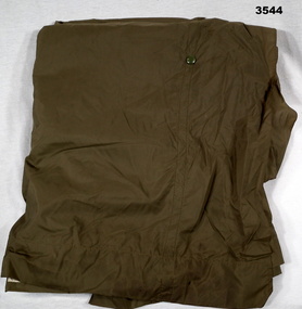
Equipment - SLEEPING BAG OUTER, 1964
Belonged to 3789179 Pte Frank FRIGERIO, 7 RAR, Apr 1967 - Apr 1968.Australian Army pattern sleeping bag outer, blue. Shaped like a sleeping bag with thin nylon construction. Half of one side is open, but can be shut with the aid of press studs.equipment, sleeping bag, outer -
 Bendigo Military Museum
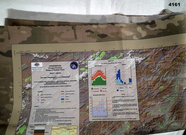
Map - MAP of AFGHANISTAN, Australian Government department of defence, Details as of March 2013
... Australian Government department of defence ...Synthetics cloth coloured map of Uruzgan Province Afghanistan, scale 1: 300,000, Escape and evasion type. Has graphs, charts, elevations.maps, afghanistan -
 Bendigo Military Museum
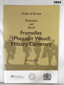
Booklet - BOOKLET WW1, Dedication & Burial - Fromelles (Pleasant Wood) Military Cemetery, 2010
... Booklet BOOKLET WW1 Australian Government, Department of Veterans ...Soft cover, glossy paper. Black print on gold background showing soldiers in silhouette. Front cover to page 20 printed in English. Back cover to page 20 printed in French. 20 English & 20 French cut, plain, white pages. Illustrated black / white / colour photos & maps.Printed on front: “Order of Service Dedication and Burial Fromelles (Pheasant Wood) Military Cemetery 19 July 2010” Printed on back: “Protocole de la Ceremononie Inauguration et Inhumation Fromelles (Pheasant Wood) Military Cemetery 19 Juillet 2010”booklet, fromelles, dedication, pheasant wood -
 Bendigo Military Museum
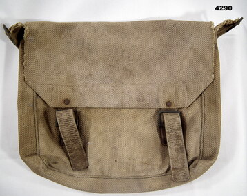
Equipment - SIDE PACK, WEBBING, WW1 era
Item belonged to 2615 Harry COWLEY 7 Battalion AIF and when returned to Australia 22 Battalion AIF. Refer CAT No. 347.3 for his service details.A WW1 soldiers webbing side pack, khaki in colour, well worn. Two leather straps and metal buckles probably brass. Brass buckles for a shoulder strap (not included) Machine stitched. Straps and buckles secured with metal rivets. One internal webbing divide. Inside flap stamped CG (arrow) 1918ww1, soldiers, webbing, ww1 aif kit -
 Bendigo Military Museum
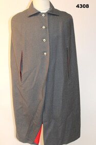
Uniform - NURSES CAPE, Australian Government Clothing Factory, 1986
... . Uniform NURSES CAPE Australian Government Clothing Factory ...Worn by Captain Linda Elliott Regt No F236731 A.A.N.C as part of her Nurses uniform. Australian Army Nursing Corp.Grey woollen long length cape , with red cotton lining. Four silver buttons embossed with crown and lantern.Inside R side of the cape. Handwritten on label: “Capt ELLIOTT. “ / Printed label: “AGCF / 1986./ Size 14” Handwritten: “F236731”cape, military, nurse -
 Bendigo Military Museum
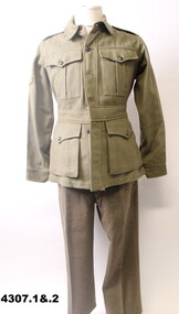
Uniform - BATTLE DRESS - JACKET AND TROUSERS, 1942
Issued to VX 140967 Lance Corporal MASON, refer Cat No 3979.2 for his service details.2nd AIF WW2 Soldier's uniform jacket and trousers. Khaki colour. Jacket has embossed buttons "Australian Military Forces". Both shoulders have colour patches of the 2/38th Battalion. A Lance Corporal's strip is on the right sleeve. Often known as Service Dress or SDs.Inside jacket labelled "Made In Australia V46 1942 Size 14. Label for Regimental Number and Name. Also a Government arrow "O^O". Trouser inside label "Made in Australia V93 1942 Size 16. Label for Regimental Number and Name. uniform, aif, jacket, trousers, 2/38th battalion -
 Bendigo Military Museum
Memorabilia - COIN, COMMEMORATIVE, 1990
... - souvenirs government - federal .1) Coin: 5 Australian Dollars, 75th ...Item relates to S W Ross VX78589, refer to Cat No 3147 for his service details..1) Coin: 5 Australian Dollars, 75th Anniversary of ANZAC landing, gold coloured. Picture of Simpson & his donkey one side & the Queen the other. .2) Mounting Frame: Cardboard, sepia image of boats at the shore of the landing. The frame has section at rear that folds out to support the display.numismatics - coins, military history - souvenirs, government - federal -
 Bendigo Military Museum
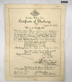
Certificate - DISCHARGE CERTIFICATE WW2, 8.12.1944
... Australian Government ...William Graham GOODMAN VX11397 enlisted in the 2nd AIF on 27.3.1940 age 33 years 2 months. 8.4.1940 posted to 2/5th Batt. 14.4.1940 embarked for the Middle East. 22.5.1940 hospitalised with Otitis Media (ear infection). Rejoined unit 27.5 1940. 14.6.1940 hospitalised with a throat infection. Rejoined unit 16.6.1940. 27.7.1940 transferred to 6th Division ASC. From here he served in Ammunition and Composite Coy’s in 6th Div ASC and graded Group 2 Mechanic MT. 24.3.1941 embarked for Greece. 5.6.1941 reported as missing. 15.12.1941 officially reported as POW in Stalag V111B. 17.5.1944 as part of a POW exchange he embarked from Barcelona to Algiers then Alexandria arriving on 2.6.1944. He is admitted to No 5 NZ GH with Dyspepsia and discharged on 9.6.1944. 28.8.1944 embarked for Australia as a medical casualty. 29.9.1944 arrived Sydney. Hospital again with Dysentry and is medically down graded to D. 6.12.1944 marched out to GDD for discharge. 18.2.1945 discharged from the Army. A document in his records that he supplied details states his POW No 24198. He was captured on 1.6.1941 on Crete and they were on rear guard action at their post when the Island capitulated. It also details living conditions, clothing issue, food, sanitary, treatment, parcels etc. Ref Reg No's 3768, 3569, 3570, 3571, 3572, 3573. A4 certificate, yellowed, folded 8 times. Certificate of Discharge for VX11397 William Graham GOODMAN, Certificate No 151615. AIF Royal Park 8.12.1944.certificate, discharge, aif -
 Bendigo Military Museum
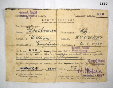
Document - DECLARATION, GERMAN WW2, 30.10.1942
William GOODMAN, POW German Prison Camp Lazarette, Lamsdorf. Chief Doctor authorizes discharge home to Australia on 30.10.1942. Ref Reg No's 3568 for his service history, 3569, 3570, 3571, 3572, 3573. German notification discharge due to ill health from POW Camp on 30.10.1942.document, declaration, pow -
 Bendigo Military Museum
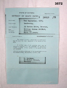
Document - EXTRACT OF DEATH, 1978
... Australian Government ...William GOODMAN VX11397 ex AIF & POW Germany. Died 8.9.1978, Dandenong. Ref Cat No's 3568 for his service history, 3569, 3570, 3571, 3572, 3573.Extract of Death Entry No 20918/78, blue paper.document, extract, death -
 Bendigo Military Museum
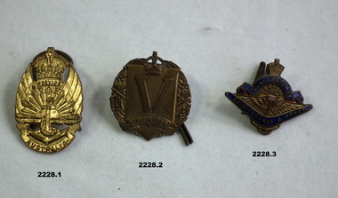
Badge - SERVICE BADGES, 1) 1948, .2) 1940 .3) post 1940
.1) Is classed a a General Service Badge type 2. .2) Is classed as a General Service Badge type 1. Types 2 was introduced in 1946. Both badges are basically for Volunteered for active service but were retained permanently or temporarily in Australia for home service..1) Badge, metal, brass coloured, crown at top, centre has wings, rising sun and anchor. Two small scrolls have "Service Australia". Rear has 2 lugs and pin, stamped with issue no. .2) badge, brass, circular wreath with plaque shape centre, At top is a crown centre of the plaque is a large "V" under in a scroll is "volunteer". Rear has 2 lugs and pins, stamped no badge. .3) badge, brass with depiction of rising sun, wings and anchor at top is a crown, under is a scroll with "Aust Legion of". At bottom is a boomerang with "Ex Servicemen and Women". Rear has 2 lugs and pins. Badge is stamped with a number. .1) "Issued by commonwealth government A 120025". .2) "Issued by commonwealth government A 6132". .3) "V 19105".badges, service -
 Bendigo Military Museum
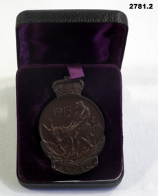
Memorabilia - MEDALLION WW1, Australian Government, c.1965
... . Memorabilia MEDALLION WW1 Australian Government ...Heavy copper medallion commemorating 50th Year Gallipoli landing. Circular pattern with a crown on top. Centre motif is an image of Simpson & his donkey. The bottom has a wreath & a banner with the word ANZAC. The reverse shows a map of Australia & New Zealand & the Southern Cross. On the bottom banner is engraved the name "T H POCOCK" The metal case is covered in black vinyl. Inside lid has purple silk. A pop up floor, covered in velvet, has an indentation the shape of the medallion."T H POCOCK"government - federal government - mementoes, anzac, passchendaele barracks trust. -
 Bendigo Military Museum
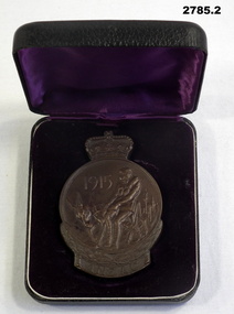
Memorabilia - MEDALLION WW1, BOXED, Australian Government, c.1965
... of the medallion. Memorabilia MEDALLION WW1, BOXED Australian Government ...Heavy copper medallion commemorating 50th Year Gallipoli landing. Circular pattern with a crown on top. Centre motif is an image of Simpson & his donkey. The bottom has a wreath & a banner with the word ANZAC. The reverse shows a map of Australia & New Zealand & the Southern Cross. On the bottom banner is engraved the name J G BOND. The metal case is covered in black vinyl. Inside lid has purple silk. A pop up floor, covered in velvet, has an indentation the shape of the medallion.“J G BOND”government - federal government - mementoes, military history, anzac, passchendaele barracks trust -
 Bendigo Military Museum
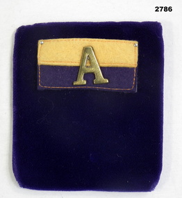
Accessory - COLOUR PATCH AND “A”, Australian Government, Post 1915
... with purple velour. Accessory COLOUR PATCH AND “A” Australian ...Felt colour patch, rectangular shape divided horizontally, top half is yellow 14th Battalion, bottom half is dark blue. A capital letter A is mounted in centre of patch. The colour patch is mounted on a card with purple velour.uniforms - badges (cloth), military history, anzac, colour patch, passchendaele barracks trust -
 Bendigo Military Museum
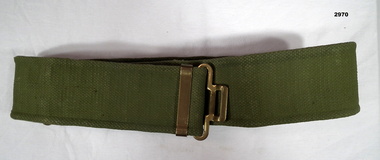
Uniform - BELT, ARMY, Commonwealth Government Clothing Factory, 1967
Belt, Australian Army Pattern 37, green webbing, brass fittings.Stamped inside: “Norma - CGCF 1967”uniforms - military/army, webbing, passchendaele barracks trust -
 Bendigo Military Museum
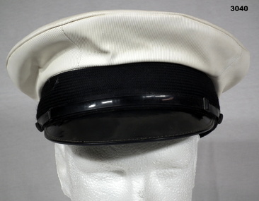
Instrument - CAP, PEAKED, R.A.N, Commonwealth Government Clothing Factory
There is some old newspaper under the brown internal hat band. See also Reg No's 3041 Beret & 3042.4 Badges.Peaked cap, white with black leather peak with black leather chin strap. External hat band is black, soft woven material. Internal hat band is brown leather.“CGCF, Size 7 1/8, RAN, Made in Australia”uniform - navy, costume - male, headwear -
 Bendigo Military Museum
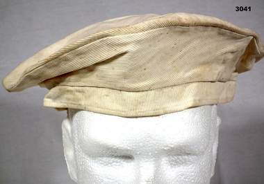
Headwear - BERET, RAN, Commonwealth Government Clothing Factory, Post WW2
L. Schilling collection.RAN Beret, white, stiff cotton woven with strong thread lines in one direction.Tag inside: “CGCF, Size 7 3/8, RAN, Made in Australia”uniforms - navy, costume - male headwear, ran -
 Bendigo Military Museum
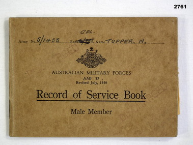
Book - SERVICE BOOK, KOREA, Australian Government, Record of Service, 1950
... , KOREA Australian Government ...Book, Australian Military Forces, Record of Service, Male Member. Brown cardboard cover, printed black ink, Commonwealth of Australia crest."Army No: 5/1455 Rank: CPL Name: Tupper N"documents - army records, military history - service records, passchendaele barracks trust -
 Federation University Historical Collection
Article - Article - Women, Women of Note: Author and Activist; Doctor Beatrice Faust, (1939-2019)
Beatrice Faust was born Beatrice Eileen Fennessey in Glen Huntly, a suburb of Melbourne, on 19 February 1939. She was educated at Mac Robertson Girls' High. She attended Melbourne University in the 1950s, where she became acquainted with Germaine Greer and they extended their feminist inclinations. She earned her bachelor's degree in English and subsequently her master's degree. The first of her two marriages was to Clive Faust during her time at university. Having become known as a public figure with the Faust surname, when they later divorced she retained the name. She was one of the first women to argue for civil liberties, abortion law reform and well-informed sex education for all. In 1966 she co-founded the Victorian Union of Civil Liberties to advocate for civil rights and, in 1972, the Women's Electoral Lobby (WEL), to agitate for legislative reform along specifically feminist lines and to give Australian women a greater voice in politics. In the latter part of her career, Bea became a lecturer in English at RMIT in Melbourne, then from 1990-2003 she was at Monash University’s campus at Churchill, Gippsland, (now Federation University) where she was an educational designer in the Centre of Learning and Teaching Support. She retired at 67. In 2001 Faust was awarded the Centenary Medal. In the same year, she was inducted into the Victorian Honour Roll of Women. In 2004 she was appointed an Officer of the Order of Australia for such efforts and more. "Today we pay tribute to one of Victoria’s great feminist leaders, Dr Beatrice Faust AO, who sadly passed away yesterday. Beatrice tirelessly advocated for women’s rights and equality in government policy and for the right to abortion, amongst many other achievements. We recognise her contribution to making Victoria a more gender equal state." Statement from Gender Equity.women of note, beatrice faust, beatrice fennessey, melbourne, macrobertson girls' high, melbourne university, germaine greer, civil liberties, abortion law, informed sex education, victorian union of civil liberties, women's electoral lobby, centenary medal, order of australia, victorian honour roll of australia, gender equity, lecturer, rmit, royal melbourne intitute of technology, monash university, churchill, gippsland -
 Federation University Historical Collection
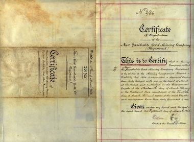
Document, Certificate of Registration: New Garibaldi Gold Mining Company, 1866, 1866
Certificate issued for the registration of the New Garibaldi Gold Mining Company by the Court of Mines Ballarat. This was published in the Government Gazette , 13 March 1866 and in the Ballarat Star newspaper on 12 March 1866. These items were submitted to the Court of Mines and the registration certificate issued on 15 March 1866. It was under the Mining Companies Limited Liability Act 1864 (Frasers Act)Yellowing paper (vellum), hand written in black inkDate:15 March 1866 Certificate No: 2/66 Stamp of Court of Mines Ballarat Signed by the Clerk of the Court of Minescourt of mines ballarat, new garibaldi gold mining company, frasers act, certificate, mining -
 Federation University Historical Collection
Photograph - Photograph - Colour, Social Distancing Signs during the Covid-19 Pandemic, 2020, 06/04/2020
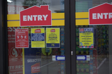
... %, the lowest in Australian history. On 22 March, the government...%, the lowest in Australian history. On 22 March, the government ...On 12 January, the World Health Organization (WHO) confirmed that a novel coronavirus was the cause of a respiratory illness in a cluster of people in Wuhan City, Hubei Province, China, who had initially come to the attention of the WHO on 31 December 2019. On 3 March, the Reserve Bank of Australia became the first central bank to cut interest rates in response to the outbreak. Official interest rates were cut by 0.25% (25 base points) to a record low of 0.5%. On 12 March, the Federal Government announced a A$17.6 billion stimulus package, the first since the 2008 GFC. he package consists of multiple parts, a one-off A$750 payment to around 6.5 million welfare recipients as early as 31 March 2020, small business assistance with 700,000 grants up to $25,000 and a 50% wage subsidy for 120,000 apprenticies or trainees for up to 9 months, 1 billion to support economically impacted sectors, regions and communities, and $700 million to increase tax write off and $3.2 billion to support short-term small and medium-sized business investment. On 16 March, Premier Dan Andrews and Minister for Health Jenny Mikakos declared a state of emergency for Victoria for at least four weeks. On 19 March, the Reserve Bank again cut interest rates by a further 0.25% to 0.25%, the lowest in Australian history. On 22 March, the government announced a second stimulus package of A$66bn, increasing the amount of total financial package offered to A$89bn. This included several new measures like doubling income support for individuals on Jobseeker's allowance, granting A$100,000 to small and medium-sized businesses and A$715 million to Australian airports and airlines. It also allowed individuals affected by the outbreak to access up to A$10,000 of their superannuation during 2019–2020 and also being able to take an additional same amount for the next year. on the same day Victorian Premier Daniel Andrews announced on 22 March that the state will bring the school holiday forwards to 24 March from 27 March. On 30 March, the Australian Federal Government announced a $130 billion "JobKeeper" wage subsidy program offering to pay employers up to $1500 a fortnight per full-time, part-time or casual employee that has worked for that business for over a year. For a business to be eligible, they must have lost 30% of turnover after 1 March of annual revenue up to and including $1 billion. For businesses with a revenue of over $1 billion, turnover must have decreased by 50%. Businesses are then required by law to pay the subsidy to their staff, in lieu of their usual wages. This response came after the enormous job losses seen just a week prior when an estimated 1 million Australians lost their jobs. This massive loss in jobs caused the myGov website to crash and lines out of Centrelink offices to run hundreds of metres long.The program was backdated to 1 March, to aim at reemploying the many people who had just lost their jobs in the weeks before. Businesses would receive the JobKeeper subsidy for six months. Victoria's "Second Wave" from Ballarat Courier, 05 August 2020 Wednesday, August 5: 725 cases, 15 deaths. A record figure reached yet again. Tuesday, August 4: 439 cases, 11 deaths. New fines introduced for COVID-infected people who aren't home. Monday, August 3: 429 cases, 13 deaths. Premier details mass industry shutdowns in Melbourne. Sunday, August 2: 671 cases, seven deaths as harsh new statewide lockdowns are announced Saturday, August 1: 397 new cases, three deaths Friday, July 31: 627 new cases, eight deaths. Premier says one in four Covid cases not home when checked. Thursday July 30: 723 cases, 13 deaths. Just when it was looking promising, alarming new record set. Wednesday July 29: 295 new cases, nine deaths as new cases drop below 300 for first time in nine days Tuesday July 28: 380 new cases, six deaths as aged care outbreaks continue to climb Monday July 27: 532 new cases as daily cases hits 500 for first time, six deaths Sunday July 26: 459 new cases as double-digit death toll is recorded for first time with 10 deaths Saturday July 25: 357 new cases, five new deaths Friday July 24: 300 cases, six deaths, ADF role expanded to help with contact tracing. Thursday July 23 - 403 cases, five deaths, worst day for fatalities in any state, masks now mandatory Wednesday July 22 - 484 cases, two deaths Tuesday July 21 - 374 cases, three deaths Monday July 20 - 275 cases, one death Sunday July 19 - 363 cases, three deaths, notice that masks will become mandatory in lockdown areas Saturday July 18 - 217 cases, three deaths, final Melbourne public housing tower released from hard lockdown Friday July 17 - 428 cases, three deaths Thursday July 16 - 317 cases, two deaths Wednesday July 15 - 238 cases, one death Tuesday July 14 - 270 cases, two deaths Monday July 13 - 177 cases Sunday July 12 - 273 cases, one death Saturday July 11 - 216 cases, one death Friday July 10 - 288 cases, a national daily record at the time Thursday July 9 - 165 cases, eight of nine Melbourne public housing towers released from hard lockdown Wednesday July 8 - 134 cases, new stage-three restrictions announced for metropolitan Melbourne and Mitchell Shire Tuesday July 7 - 191 cases Monday July 6 - 127 cases, two deaths, NSW border closed Sunday July 5 - 74 cases Saturday July 4 - 108 cases, immediate hard lockdown of nine Melbourne public housing towers Friday July 3 - 66 cases Thursday July 2 - 77 cases Wednesday July 1 - 73 casesColour photographs of social distancing signs during the Covid-19 Pandemic, on Chemist Warehouse in Sebastopol. On 06 April 2020 a maximum of 75 people were allowed in the chemist at one time, and those with syptoms of Covid-19 (fever, cough, shortness of breath) were asked to not enter without phone contact. Upon entering customers were directed to use hand sanitizer, and 1.5 metre markings were placed on the floor to enable legal social distancing.covid-19, corona virus, pandemic, chemist's warehouse, sebastopol, social distancing -
 Federation University Historical Collection
Photograph - Photograph - Colour, E.J. Barker Library Social Distancing During the Covid19 Pandemic, 2020, 06/04/2020
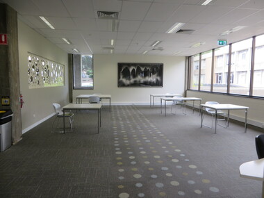
... %, the lowest in Australian history. On 22 March, the government...%, the lowest in Australian history. On 22 March, the government ...On 12 January, the World Health Organization (WHO) confirmed that a novel coronavirus was the cause of a respiratory illness in a cluster of people in Wuhan City, Hubei Province, China, who had initially come to the attention of the WHO on 31 December 2019. On 3 March, the Reserve Bank of Australia became the first central bank to cut interest rates in response to the outbreak. Official interest rates were cut by 0.25% (25 base points) to a record low of 0.5%. On 12 March, the Federal Government announced a A$17.6 billion stimulus package, the first since the 2008 GFC. he package consists of multiple parts, a one-off A$750 payment to around 6.5 million welfare recipients as early as 31 March 2020, small business assistance with 700,000 grants up to $25,000 and a 50% wage subsidy for 120,000 apprenticies or trainees for up to 9 months, 1 billion to support economically impacted sectors, regions and communities, and $700 million to increase tax write off and $3.2 billion to support short-term small and medium-sized business investment. On 16 March, Premier Dan Andrews and Minister for Health Jenny Mikakos declared a state of emergency for Victoria for at least four weeks. On 19 March, the Reserve Bank again cut interest rates by a further 0.25% to 0.25%, the lowest in Australian history. On 22 March, the government announced a second stimulus package of A$66bn, increasing the amount of total financial package offered to A$89bn. This included several new measures like doubling income support for individuals on Jobseeker's allowance, granting A$100,000 to small and medium-sized businesses and A$715 million to Australian airports and airlines. It also allowed individuals affected by the outbreak to access up to A$10,000 of their superannuation during 2019–2020 and also being able to take an additional same amount for the next year. on the same day Victorian Premier Daniel Andrews announced on 22 March that the state will bring the school holiday forwards to 24 March from 27 March. On 30 March, the Australian Federal Government announced a $130 billion "JobKeeper" wage subsidy program offering to pay employers up to $1500 a fortnight per full-time, part-time or casual employee that has worked for that business for over a year. For a business to be eligible, they must have lost 30% of turnover after 1 March of annual revenue up to and including $1 billion. For businesses with a revenue of over $1 billion, turnover must have decreased by 50%. Businesses are then required by law to pay the subsidy to their staff, in lieu of their usual wages. This response came after the enormous job losses seen just a week prior when an estimated 1 million Australians lost their jobs. This massive loss in jobs caused the myGov website to crash and lines out of Centrelink offices to run hundreds of metres long.The program was backdated to 1 March, to aim at reemploying the many people who had just lost their jobs in the weeks before. Businesses would receive the JobKeeper subsidy for six months.Colour photographs of furniture placed for social distancing in the Federation University E.J Barker Library during the Covid-19 Pandemic. The next day the library was closed all except staff.covid-19, corona virus, pandemic, library, e.j. barker library, mt helen library -
 Federation University Historical Collection
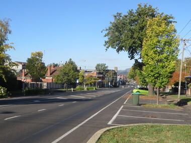
Photograph, Dana Street, Ballarat During Covid-19 State of Emergency, 13/04/2020
... %, the lowest in Australian history. On 22 March, the government...%, the lowest in Australian history. On 22 March, the government ...On 12 January, the World Health Organization (WHO) confirmed that a novel coronavirus was the cause of a respiratory illness in a cluster of people in Wuhan City, Hubei Province, China, who had initially come to the attention of the WHO on 31 December 2019. On 3 March, the Reserve Bank of Australia became the first central bank to cut interest rates in response to the outbreak. Official interest rates were cut by 0.25% (25 base points) to a record low of 0.5%. On 12 March, the Federal Government announced a A$17.6 billion stimulus package, the first since the 2008 GFC. he package consists of multiple parts, a one-off A$750 payment to around 6.5 million welfare recipients as early as 31 March 2020, small business assistance with 700,000 grants up to $25,000 and a 50% wage subsidy for 120,000 apprenticies or trainees for up to 9 months, 1 billion to support economically impacted sectors, regions and communities, and $700 million to increase tax write off and $3.2 billion to support short-term small and medium-sized business investment. On 16 March, Premier Dan Andrews and Minister for Health Jenny Mikakos declared a state of emergency for Victoria for at least four weeks. On 19 March, the Reserve Bank again cut interest rates by a further 0.25% to 0.25%, the lowest in Australian history. On 22 March, the government announced a second stimulus package of A$66bn, increasing the amount of total financial package offered to A$89bn. This included several new measures like doubling income support for individuals on Jobseeker's allowance, granting A$100,000 to small and medium-sized businesses and A$715 million to Australian airports and airlines. It also allowed individuals affected by the outbreak to access up to A$10,000 of their superannuation during 2019–2020 and also being able to take an additional same amount for the next year. on the same day Victorian Premier Daniel Andrews announced on 22 March that the state will bring the school holiday forwards to 24 March from 27 March. On 30 March, the Australian Federal Government announced a $130 billion "JobKeeper" wage subsidy program offering to pay employers up to $1500 a fortnight per full-time, part-time or casual employee that has worked for that business for over a year. For a business to be eligible, they must have lost 30% of turnover after 1 March of annual revenue up to and including $1 billion. For businesses with a revenue of over $1 billion, turnover must have decreased by 50%. Businesses are then required by law to pay the subsidy to their staff, in lieu of their usual wages. This response came after the enormous job losses seen just a week prior when an estimated 1 million Australians lost their jobs. This massive loss in jobs caused the myGov website to crash and lines out of Centrelink offices to run hundreds of metres long.The program was backdated to 1 March, to aim at reemploying the many people who had just lost their jobs in the weeks before. Businesses would receive the JobKeeper subsidy for six months. * On 12 April 2020 Victorian Premier Daniel Andrews Extended the State of Emergency until midnight on May 11. On this day the world has 1,604,900 cases of coronavirus, with 95,738 deaths. America has 468,887 cases of covid19, with 1,900 Americans dying in the last 24 hours. The UK has 65,077 cases. 881 people died in the last 24 hours. Australia has 6,292 cases. 58 people have died to date.Colour photographs of Ballarat's usually very busy Dana Street during Covid-19 Social Isoliation. The photographs were taken at 4.00pm. dana street, ballarat, covid19, corona virus, pandemic, state of emergency -
 Federation University Historical Collection
Photograph - Photograph - Colour, Eyre Street, Ballarat During Covid-19 State of Emergency, 13/04/2020
... %, the lowest in Australian history. On 22 March, the government...%, the lowest in Australian history. On 22 March, the government ...On 12 January, the World Health Organization (WHO) confirmed that a novel coronavirus was the cause of a respiratory illness in a cluster of people in Wuhan City, Hubei Province, China, who had initially come to the attention of the WHO on 31 December 2019. On 3 March, the Reserve Bank of Australia became the first central bank to cut interest rates in response to the outbreak. Official interest rates were cut by 0.25% (25 base points) to a record low of 0.5%. On 12 March, the Federal Government announced a A$17.6 billion stimulus package, the first since the 2008 GFC. he package consists of multiple parts, a one-off A$750 payment to around 6.5 million welfare recipients as early as 31 March 2020, small business assistance with 700,000 grants up to $25,000 and a 50% wage subsidy for 120,000 apprenticies or trainees for up to 9 months, 1 billion to support economically impacted sectors, regions and communities, and $700 million to increase tax write off and $3.2 billion to support short-term small and medium-sized business investment. On 16 March, Premier Dan Andrews and Minister for Health Jenny Mikakos declared a state of emergency for Victoria for at least four weeks. On 19 March, the Reserve Bank again cut interest rates by a further 0.25% to 0.25%, the lowest in Australian history. On 22 March, the government announced a second stimulus package of A$66bn, increasing the amount of total financial package offered to A$89bn. This included several new measures like doubling income support for individuals on Jobseeker's allowance, granting A$100,000 to small and medium-sized businesses and A$715 million to Australian airports and airlines. It also allowed individuals affected by the outbreak to access up to A$10,000 of their superannuation during 2019–2020 and also being able to take an additional same amount for the next year. on the same day Victorian Premier Daniel Andrews announced on 22 March that the state will bring the school holiday forwards to 24 March from 27 March. On 30 March, the Australian Federal Government announced a $130 billion "JobKeeper" wage subsidy program offering to pay employers up to $1500 a fortnight per full-time, part-time or casual employee that has worked for that business for over a year. For a business to be eligible, they must have lost 30% of turnover after 1 March of annual revenue up to and including $1 billion. For businesses with a revenue of over $1 billion, turnover must have decreased by 50%. Businesses are then required by law to pay the subsidy to their staff, in lieu of their usual wages. This response came after the enormous job losses seen just a week prior when an estimated 1 million Australians lost their jobs. This massive loss in jobs caused the myGov website to crash and lines out of Centrelink offices to run hundreds of metres long.The program was backdated to 1 March, to aim at reemploying the many people who had just lost their jobs in the weeks before. Businesses would receive the JobKeeper subsidy for six months. * On 12 April 2020 Victorian Premier Daniel Andrews Extended the State of Emergency until midnight on May 11. On this day the world has 1,604,900 cases of coronavirus, with 95,738 deaths. America has 468,887 cases of covid19, with 1,900 Americans dying in the last 24 hours. The UK has 65,077 cases. 881 people died in the last 24 hours. Australia has 6,292 cases. 58 people have died to date.Colour photographs of Ballarat's usually very busy Eyre Street during Covid-19 Social Isoliation. The photographs were taken at 4.00pm. ballarat, covid19, corona virus, pandemic, state of emergency, eyre street -
 Federation University Historical Collection
Map - Geological, U.S. Government Printing Office, Bathymetric Map of the Indonesian Region: Folio of the Indonesian Region Map I-875-A, 1974, 1974
Map was prepared on behalf of the Government of Indonesia, The United Nations Economic Commission for Asia and the Far East, the Agency for International Development and the U.S. Department of State in cooperation with the Geological Survey of Indonesia. The area covered shows the islands and seas from Latitude 12 degree North to 16 degrees South and Longitude 90 degrees to 148 degrees. Various water features are also named.Large map showing the Indonesian area - islands and seasLongitude and Latitude are shown. Major / Capitol cities indicated. Names of those responsible for the productionindonesia, united nations economic commission, department of state, geological survey, latitude, longitude, government of indonesia -
Federation University Historical Collection
Booklet, Victorian Minerals Education Centre, c1990
Ballarat University College (Now Federation University) was designated by the State Government as the centre for Mining Engineering Education in Victoria. The Victorian Minerals Education Centre was estabioshed in 1990 with a grant from teh Victorian Education Foundation to provide Victoria with a centre of excellence to support development of mineral resources.Promotional brochure for the Victorian Minerals Education Centrevictorian minerals education centre, vmec, richard croggon, pete dahlhaus, steve carey, stafford mcknight, w.r.h. ramsay, brian sunter, c. swaminathan, s. zang, mining engineering, geology, metallurgy -
Federation University Historical Collection
Poster, Victorian Department of Health and Human Services, A number of Covid-19 Posters Produced by the Victorian Departent of Health and Human Services, 2021, 11/06/2021
... %, the lowest in Australian history. On 22 March, the government...%, the lowest in Australian history. On 22 March, the government ...On 12 January, the World Health Organization (WHO) confirmed that a novel coronavirus was the cause of a respiratory illness in a cluster of people in Wuhan City, Hubei Province, China, who had initially come to the attention of the WHO on 31 December 2019. On 3 March, the Reserve Bank of Australia became the first central bank to cut interest rates in response to the outbreak. Official interest rates were cut by 0.25% (25 base points) to a record low of 0.5%. On 12 March, the Federal Government announced a A$17.6 billion stimulus package, the first since the 2008 GFC. he package consists of multiple parts, a one-off A$750 payment to around 6.5 million welfare recipients as early as 31 March 2020, small business assistance with 700,000 grants up to $25,000 and a 50% wage subsidy for 120,000 apprenticies or trainees for up to 9 months, 1 billion to support economically impacted sectors, regions and communities, and $700 million to increase tax write off and $3.2 billion to support short-term small and medium-sized business investment. On 16 March, Premier Dan Andrews and Minister for Health Jenny Mikakos declared a state of emergency for Victoria for at least four weeks. On 19 March, the Reserve Bank again cut interest rates by a further 0.25% to 0.25%, the lowest in Australian history. On 22 March, the government announced a second stimulus package of A$66bn, increasing the amount of total financial package offered to A$89bn. This included several new measures like doubling income support for individuals on Jobseeker's allowance, granting A$100,000 to small and medium-sized businesses and A$715 million to Australian airports and airlines. It also allowed individuals affected by the outbreak to access up to A$10,000 of their superannuation during 2019–2020 and also being able to take an additional same amount for the next year. on the same day Victorian Premier Daniel Andrews announced on 22 March that the state will bring the school holiday forwards to 24 March from 27 March. On 30 March, the Australian Federal Government announced a $130 billion "JobKeeper" wage subsidy program offering to pay employers up to $1500 a fortnight per full-time, part-time or casual employee that has worked for that business for over a year. For a business to be eligible, they must have lost 30% of turnover after 1 March of annual revenue up to and including $1 billion. For businesses with a revenue of over $1 billion, turnover must have decreased by 50%. Businesses are then required by law to pay the subsidy to their staff, in lieu of their usual wages. This response came after the enormous job losses seen just a week prior when an estimated 1 million Australians lost their jobs. This massive loss in jobs caused the myGov website to crash and lines out of Centrelink offices to run hundreds of metres long.The program was backdated to 1 March, to aim at reemploying the many people who had just lost their jobs in the weeks before. Businesses would receive the JobKeeper subsidy for six months. Victoria's "Second Wave" from Ballarat Courier, 05 August 2020 Wednesday, August 5: 725 cases, 15 deaths. A record figure reached yet again. Tuesday, August 4: 439 cases, 11 deaths. New fines introduced for COVID-infected people who aren't home. Monday, August 3: 429 cases, 13 deaths. Premier details mass industry shutdowns in Melbourne. Sunday, August 2: 671 cases, seven deaths as harsh new statewide lockdowns are announced Saturday, August 1: 397 new cases, three deaths Friday, July 31: 627 new cases, eight deaths. Premier says one in four Covid cases not home when checked. Thursday July 30: 723 cases, 13 deaths. Just when it was looking promising, alarming new record set. Wednesday July 29: 295 new cases, nine deaths as new cases drop below 300 for first time in nine days Tuesday July 28: 380 new cases, six deaths as aged care outbreaks continue to climb Monday July 27: 532 new cases as daily cases hits 500 for first time, six deaths Sunday July 26: 459 new cases as double-digit death toll is recorded for first time with 10 deaths Saturday July 25: 357 new cases, five new deaths Friday July 24: 300 cases, six deaths, ADF role expanded to help with contact tracing. Thursday July 23 - 403 cases, five deaths, worst day for fatalities in any state, masks now mandatory Wednesday July 22 - 484 cases, two deaths Tuesday July 21 - 374 cases, three deaths Monday July 20 - 275 cases, one death Sunday July 19 - 363 cases, three deaths, notice that masks will become mandatory in lockdown areas Saturday July 18 - 217 cases, three deaths, final Melbourne public housing tower released from hard lockdown Friday July 17 - 428 cases, three deaths Thursday July 16 - 317 cases, two deaths Wednesday July 15 - 238 cases, one death Tuesday July 14 - 270 cases, two deaths Monday July 13 - 177 cases Sunday July 12 - 273 cases, one death Saturday July 11 - 216 cases, one death Friday July 10 - 288 cases, a national daily record at the time Thursday July 9 - 165 cases, eight of nine Melbourne public housing towers released from hard lockdown Wednesday July 8 - 134 cases, new stage-three restrictions announced for metropolitan Melbourne and Mitchell Shire Tuesday July 7 - 191 cases Monday July 6 - 127 cases, two deaths, NSW border closed Sunday July 5 - 74 cases Saturday July 4 - 108 cases, immediate hard lockdown of nine Melbourne public housing towers Friday July 3 - 66 cases Thursday July 2 - 77 cases Wednesday July 1 - 73 casesColour posters advising on safety measures for Victorian during the 2020-2021 Covid-19 Pandemic. The posters were made available by the Department of Health and Human Services and have been saved as PDFs, and printed off onot A4 paper.covid-19, corona virus, pandemic, posters, department of health and human services