Showing 2554 items
matching historic photographs
-
 Eltham District Historical Society Inc
Photograph - Aerial Photograph, Landata, Research, Vic, Apr. 1963
Centred on present day Thompson Crescent and Nicholson Close, Research bounded by Maroondah Aqueduct to north, Nyora Road to south, Eltham College to east and Eltham Gateway Hotel to west. Historic Aerial Imagery Source: Landata.vic.gov.au Aerial Photo Details: Project No :486 Project : MELBOURNE (1963) PROJECT Run : 5 Frame : 61 Date : 04/1963 Film Type : B/W Camera : RC8 Flying Height : 5100 Scale : 9600 Film Number : 1805 GDA2020 : 37°42'24"S, 145°10'06"E MGA2020 : 338528, 5825143 (55) Melways : 22 D3 (ed. 42)aerial photo, neil webster collection, eltham, 1963-04, eltham college, eltham gateway hotel and conference centre, maroondah aqueduct, melway 22d3, nicholson close, nyora road, research (vic.), thompson crescent -
 Eltham District Historical Society Inc
Photograph - Aerial Photograph, Landata, Research, Vic, Apr. 1963
Centred on present day Marconi Court, Research bounded by Maroondah Aqueduct to north, Thompson Crescent to south, Joselyn Drive to east and Eltham Research Oval to west. Historic Aerial Imagery Source: Landata.vic.gov.au Aerial Photo Details: Project No :486 Project : MELBOURNE (1963) PROJECT Run : 5 Frame : 62 Date : 04/1963 Film Type : B/W Camera : RC8 Flying Height : 5100 Scale : 9600 Film Number : 1805 GDA2020 : 37°42'24"S, 145°10'43"E MGA2020 : 339434, 5825157 (55) Melways : 22 F3 (ed. 42)aerial photo, neil webster collection, 1963-04, joselyn drive, marconi court, melway 22f3, research (vic.), research oval, thompson crescent -
 Eltham District Historical Society Inc
Photograph - Aerial Photograph, Landata, Eltham, Vic, Apr. 1963
Centred on present day John Street, Eltham between Main and Bible streets bounded by Elsa Court to north, Main Road Bridge to south, Wattle Grove to east and Bolton Street to west. Historic Aerial Imagery Source: Landata.vic.gov.au Aerial Photo Details: Project No :486 Project : MELBOURNE (1963) PROJECT Run : 6 Frame : 123 Date : 04/1963 Film Type : B/W Camera : RC8 Flying Height : 5100 Scale : 9600 Film Number : 1805 GDA2020 : 37°43'12"S, 145°08'54"E MGA2020 : 336800, 5823623 (55) Melways : 21 J6 (ed. 42)aerial photo, neil webster collection, 1963-04, bolton steet, elsa court, eltham, john street, main road, main road bridge, melway 21j6, wattle grove -
 Eltham District Historical Society Inc
Photograph - Aerial Photograph, Landata, Eltham, Vic, Apr. 1963
Centred on present day Eltham Ridge, Bolton Street, Eltham bounded by Elsa Court to north, Main Road to south, Bible Street to east and Reichelt Avenue and Rattray Road to west. Historic Aerial Imagery Source: Landata.vic.gov.au Aerial Photo Details: Project No :486 Project : MELBOURNE (1963) PROJECT Run : 6 Frame : 124 Date : 04/1963 Film Type : B/W Camera : RC8 Flying Height : 5100 Scale : 9600 Film Number : 1805 GDA2020 : 37°43'12"S, 145°08'16"E MGA2020 : 335876, 5823604 (55) Melways : 21 G6 (ed. 42)aerial photo, neil webster collection, 1963-04, bible street, bolton street, eltham, eltham ridge, main road, montmorency, rattray road, reichelt avenue -
 Eltham District Historical Society Inc
Photograph - Aerial Photograph, Landata, Lower Plenty, Vic, Apr. 1963
Centred on present day Old Eltham Road near Araluen Centre, Lower Plenty bounded by Cromwell Street to north, Yarra River to south, Main Road at Mount Pleasant Road to east and Panorama Avenue to west. Historic Aerial Imagery Source: Landata.vic.gov.au Aerial Photo Details: Project No :486 Project : MELBOURNE (1963) PROJECT Run : 7 Frame : 231 Date : 04/1963 Film Type : B/W Camera : RC8 Flying Height : 5100 Scale : 9600 Film Number : 1805 GDA2020 : 37°44'03"S, 145°07'56"E MGA2020 : 335420, 5822027 (55) Melways : 21 F10 (ed. 42)aerial photo, neil webster collection, 1963-04, araluen, cromwell street, eltham, lower plenty, main road, melway 21f10, mount pleasant road, old eltham road, panorama avenue, yarra river -
 Eltham District Historical Society Inc
Photograph - Aerial Photograph, Landata, Eltham, Vic, Apr. 1963
Centred on present day Eltham Lower Park bounded by Brougham Street to north, Yarra River and Fitzsimons Lane Bridge to south, Main Road at Kent Hughes Road to east and Bolton Street to west. Historic Aerial Imagery Source: Landata.vic.gov.au Aerial Photo Details: Project No :486 Project : MELBOURNE (1963) PROJECT Run : 7 Frame : 232 Date : 04/1963 Film Type : B/W Camera : RC8 Flying Height : 5100 Scale : 9600 Film Number : 1805 GDA2020 : 37°44'03"S, 145°08'33"E MGA2020 : 336329, 5822040 (55) Melways : 21 H10 (ed. 42)aerial photo, neil webster collection, 1963-04, bolton steet, brougham steet, eltham, eltham lower park, fitzsimons lane bridge, kent hughes road, melway 21h10, yarra river -
 Eltham District Historical Society Inc
Photograph - Aerial Photograph, Landata, Eltham, Vic, Apr. 1963
Centred on present day Griffith Park Road, Eltham bounded by Mount Pleasant Road to north, Yarra River and Templestowe to south, Main Road at Reynolds Road to east and Falkiner Street to west. Historic Aerial Imagery Source: Landata.vic.gov.au Aerial Photo Details: Project No :486 Project : MELBOURNE (1963) PROJECT Run : 7 Frame : 233 Date : 04/1963 Film Type : B/W Camera : RC8 Flying Height : 5100 Scale : 9600 Film Number : 1805 GDA2020 : 37°44'04"S, 145°09'10"E MGA2020 : 337237, 5822053 (55) Melways : 22 A10 (ed. 42)aerial photo, neil webster collection, 1963-04, eltham, falkiner street, griffith park road, melway 22a10, mount pleasant road, reynolds road, templestowe, yarra river -
 Eltham District Historical Society Inc
Photograph - Aerial Photograph, Landata, Eltham North, Vic, Apr. 1972
Centred on present day Eltham North reserve near Eltham North Primary School, Eltham North bounded by Allendale Road to north, Bellevue Road to south, Zig Zag Road and Beard Street to east and Ryans Road to west. Historic Aerial Imagery Source: Landata.vic.gov.au Aerial Photo Details: Project No :985 Project : MELBOURNE 1972 Run : 26 Frame : 190 Date : 04/1972 Film Type : B/W Camera : RC10 Flying Height : 5700 Scale : 9600 Film Number : 2636 GDA2020 : 37°41'52"S, 145°08'52"E MGA2020 : 336705, 5826102 (55) Melways : 11 J12 (ed. 42)aerial photo, neil webster collection, 1972-04, allendale road, beard street, bellevue road, eltham, eltham north, eltham north reserve, melway 11j12, ryans road, zig zag road, eltham north primary school -
 Eltham District Historical Society Inc
Photograph - Aerial Photograph, Landata, Eltham, Vic, Apr. 1972
Centred on present day Zig Zag Road near Coolabah Drive, Eltham bounded by Allendale Road to north, Park West Road to south, Parsons Road to east and Banks Road to west. Historic Aerial Imagery Source: Landata.vic.gov.au Aerial Photo Details: Project No :985 Project : MELBOURNE 1972 Run : 26 Frame : 191 Date : 04/1972 Film Type : B/W Camera : RC10 Flying Height : 5700 Scale : 9600 Film Number : 2636 GDA2020 : 37°41'56"S, 145°09'26"E MGA2020 : 337533, 5826000 (55) Melways : 22 A1 (ed. 42)aerial photo, neil webster collection, 1972-04, allendale road, eltham, eltham north, zig zag road, banks road, coolabah drive, melway 22a1, park west road, parsons road -
 Eltham District Historical Society Inc
Photograph - Aerial Photograph, Landata, Eltham, Vic, Apr. 1972
Centred on present day Parsons Road, Eltham bounded by Allendale Road to north, Frank Street to south, Research Shops and Raglan Road to east and Zig Zag Road to west. Historic Aerial Imagery Source: Landata.vic.gov.au Aerial Photo Details: Project No :985 Project : MELBOURNE 1972 Run : 26 Frame : 192 Date : 04/1972 Film Type : B/W Camera : RC10 Flying Height : 5700 Scale : 9600 Film Number : 2636 GDA2020 : 37°42'00"S, 145°09'59"E MGA2020 : 338360, 5825897 (55) Melways : 22 D1 (ed. 42)aerial photo, neil webster collection, 1972-04, allendale road, eltham, zig zag road, frank street, melway 22d1, parsons road, raglan road, research (vic.), research shops, eltham barrel -
 Eltham District Historical Society Inc
Photograph - Aerial Photograph, Landata, Research, Vic, Apr. 1972
Centred on present day Maroong Drive, Research bounded by Allendale Road to north, Thompson Crescent to south, Eltham College to east and Parsons Road to west. Historic Aerial Imagery Source: Landata.vic.gov.au Aerial Photo Details: Project No :985 Project : MELBOURNE 1972 Run : 26 Frame : 193 Date : 04/1972 Film Type : B/W Camera : RC10 Flying Height : 5700 Scale : 9600 Film Number : 2636 GDA2020 : 37°42'04"S, 145°10'33"E MGA2020 : 339187, 5825794 (55) Melways : 22 F1 (ed. 42)aerial photo, neil webster collection, 1972-04, allendale road, eltham, eltham barrel, eltham college, maroong drive, melway 22f1, parsons road, research (vic.), thompson crescent -
 Eltham District Historical Society Inc
Photograph - Aerial Photograph, Landata, Research, Vic, Apr. 1972
Centred on present day Main Road, Research near Maroondah Aqueduct and Eltham College bounded by Allendale Road to north, Research-Warrandyte Road to south, Swipers Gully Training Restaurant to east and Reynolds Road to west. Historic Aerial Imagery Source: Landata.vic.gov.au Aerial Photo Details: Project No :985 Project : MELBOURNE 1972 Run : 26 Frame : 194 Date : 04/1972 Film Type : B/W Camera : RC10 Flying Height : 5700 Scale : 9600 Film Number : 2636 GDA2020 : 37°42'07"S, 145°11'07"E MGA2020 : 340015, 5825692 (55) Melways : 22 H1 (ed. 42)aerial photo, neil webster collection, 1972-04, allendale road, eltham college, main road, maroondah aqueduct, melway 22h1, research (vic.), research-warrandyte road, reynolds road, swiper's gully -
 Eltham District Historical Society Inc
Photograph - Aerial Photograph, Landata, Eltham, Vic, Apr. 1972
Centred on present day Woodridge Estate, Eltham bounded by Park Road to north, Mount Pleasant Road to south, Stokes Orchard Estate to east and Eltham Railway Station to west. Historic Aerial Imagery Source: Landata.vic.gov.au Aerial Photo Details: Project No :985 Project : MELBOURNE 1972 Run : 27 Frame : 46 Date : 04/1972 Film Type : B/W Camera : RC10 Flying Height : 5700 Scale : 9600 Film Number : 2636 GDA2020 : 37°42'49"S, 145°09'46"E MGA2020 : 338053, 5824365 (55) Melways : 22 C5 (ed. 42)aerial photo, neil webster collection, 1972-04, eltham, eltham railway station, melway 22c5, mount pleasant road, park road, stokes orchard estate, woodridge estate -
 Eltham District Historical Society Inc
Photograph - Aerial Photograph, Landata, Eltham, Vic, Apr. 1972
Centred on present day Main Road at Pryor Street, Eltham bounded by Park West Road to north, Napoleon Street to south, Woodridge Estate to east and Ryans Road to west. Historic Aerial Imagery Source: Landata.vic.gov.au Aerial Photo Details: Project No :985 Project : MELBOURNE 1972 Run : 27 Frame : 47 Date : 04/1972 Film Type : B/W Camera : RC10 Flying Height : 5700 Scale : 9600 Film Number : 2636 GDA2020 : 37°42'45"S, 145°09'12"E MGA2020 : 337223, 5824470 (55) Melways : 22 A4 (ed. 42)aerial photo, neil webster collection, 1972-04, eltham, eltham railway station, woodridge estate, eltham shops, main road, melway 22a4, napoleon street, park west road, pryor street, ryans road -
 Eltham District Historical Society Inc
Photograph - Aerial Photograph, Landata, Eltham, Vic, Apr. 1972
Centred on present day Ryans Road at Sandra Avenue, Eltham bounded by Progress Road to north, Brougham Street to south, Bible Street to east and Outlook Crescent to west. Historic Aerial Imagery Source: Landata.vic.gov.au Aerial Photo Details: Project No :985 Project : MELBOURNE 1972 Run : 27 Frame : 48 Date : 04/1972 Film Type : B/W Camera : RC10 Flying Height : 5700 Scale : 9600 Film Number : 2636 GDA2020 : 37°42'41"S, 145°08'38"E MGA2020 : 336392, 5824574 (55) Melways : 21 H4 (ed. 42)aerial photo, neil webster collection, 1972-04, eltham, bible street, brougham steet, melway 21h4, outlook crescent, progress road, ryans road, sandra avenue, montmorency -
 Eltham District Historical Society Inc
Photograph - Aerial Photograph, Landata, Montmorency, Vic, Apr. 1972
Centred on present day Olympic Avenue at Grand Boulevard, Montmorency bounded by Meruka Drive to north, Main Road to south, Main Road to east and Alban Street to west. Historic Aerial Imagery Source: Landata.vic.gov.au Aerial Photo Details: Project No :985 Project : MELBOURNE 1972 Run : 28 Frame : 206 Date : 04/1972 Film Type : B/W Camera : RC10 Flying Height : 5700 Scale : 9600 Film Number : 2635 GDA2020 : 37°43'21"S, 145°07'46"E MGA2020 : 335154, 5823329 (55) Melways : 21 E7 (ed. 42)aerial photo, neil webster collection, 1972-04, eltham, alban street, grand boulevard, lower plenty, main road, melway 21e7, meruka drive, montmorency, olympic avenue -
 Eltham District Historical Society Inc
Photograph - Aerial Photograph, Landata, Eltham, Vic, Apr. 1972
Centred on present day Diamond Creek Trail at the Eltham Leisure Centre bounded by Central Park to north, Main Road at Falkiner Street to south, MacMahon Ball Paddock to east and Grand Boulevard at Buena Vista Drive to west. Historic Aerial Imagery Source: Landata.vic.gov.au Aerial Photo Details: Project No :985 Project : MELBOURNE 1972 Run : 28 Frame : 207 Date : 04/1972 Film Type : B/W Camera : RC10 Flying Height : 5700 Scale : 9600 Film Number : 2635 GDA2020 : 37°43'25"S, 145°08'20"E MGA2020 : 335985, 5823223 (55) Melways : 21 G7 (ed. 42)aerial photo, neil webster collection, 1972-04, eltham, buena vista drive, central park, diamond creek trail, eltham leisure centre, falkiner street, grand boulevard, macmahon ball paddock, main road, melway 21g7 -
 Eltham District Historical Society Inc
Photograph - Aerial Photograph, Landata, Eltham, Vic, Apr. 1972
Centred on present day Dalton Street at Mount Pleasant Road, Eltham bounded by Arthur Street to north, Yarra River and Kent Hughes Road to south, Eucalyptus Road to east and Susan Street to west. Historic Aerial Imagery Source: Landata.vic.gov.au Aerial Photo Details: Project No :985 Project : MELBOURNE 1972 Run : 28 Frame : 208 Date : 04/1972 Film Type : B/W Camera : RC10 Flying Height : 5700 Scale : 9600 Film Number : 2635 GDA2020 : 37°43'29"S, 145°08'54"E MGA2020 : 336816, 5823118 (55) Melways : 21 J8 (ed. 42)aerial photo, neil webster collection, 1972-04, eltham, arthur street, dalton street, eucalyptus road, kent hughes road, melway 21j8, mount pleasant road, susan street, yarra river -
 Eltham District Historical Society Inc
Photograph - Aerial Photograph, Landata, Eltham, Vic, Apr. 1972
Centred on present day Mays Road at Stringybark Road, Eltham bounded by Nyora Road to north, Yarra River to south, Reynolds Road to east and Bible Street to west. Historic Aerial Imagery Source: Landata.vic.gov.au Aerial Photo Details: Project No :985 Project : MELBOURNE 1972 Run : 28 Frame : 209 Date : 04/1972 Film Type : B/W Camera : RC10 Flying Height : 5700 Scale : 9600 Film Number : 2635 GDA2020 : 37°43'33"S, 145°09'28"E MGA2020 : 337647, 5823013 (55) Melways : 22 B8 (ed. 42)aerial photo, neil webster collection, 1972-04, eltham, bible street, mays road, melway 22b8, nyora road, reynolds road, stringybark road, yarra river -
 Eltham District Historical Society Inc
Document - Folder, Marshall, Marguerite
Marguerite Marshall, Eltham resident, worked as a journalist in the Diamond Valley from around 1980. In 2002, she published "Nillumbik Now and Then", about the shire's landmarks and characters (an update of "Eltham Shire, Historic Buildings, People and Places" 1983). It had photographs b Alan King and covered the Wurundjeri people, the Batman Tree legend, farmers, bushranger, gold mining, soldiers, artists, environmentalists and sportspeople. She was an environmental activist who created a comic character to show there can be a humorous side to the environmental challenge (Eartha Waters, a green tragic) for Nillumbik Climate Action Now event at Eltham Library. Contents Newspaper article: "New book on shire's past", Diamond Valley Leader, 6 February 2002, announcing publication of "Nillumbik Now and Then" by Marguerite Marshall, photographed with photographer Ron Grant and Eltham District Historical Society secretary Russell Yeoman. Newspaper article: "Humorous side on warming", Diamond Valley Leader, 4 June 2008, listing events for Nillumbik Climate Action Now marking World Environment Day, including Marguerite Marshall's character Eartha Waters. Newspaper article: "Green wedge a goldmine of history", Heidelberg and Diamond Valley Weekly, 25 November 2008, Announcing publication of Marguerite Marshall's book "Nillumbik Now and Then". Newspaper letter: "Worst, so we should lead", Diamond Valley Leader, 13 January 2010, Marguerite Marshall argued for climate action. Newspaper article: "Truths to be revealed in talk", Diamond Valley Leader, 23 July 2014, announcing talk by Marguerite Marshall on climate change at Montmorency Probus Club on 21 August and on renewable energy at Nillumbik Probus Club on 10 September 2014. Newspaper article: "Turning back the pages", Diamond Valley Leader, 19 November 2008, Announcing publication of Marguerite Marshall's book "Nillumbik Now and Then". Newspaper clippings, A4 photocopies, etcmarguerite marshall, nillumbik - now and then, eltham shire historic buildings people and places, ron grant, russell yeoman, eltham district historical society, eartha waters greenie tragic, nillumbik climate action now, alan king, montmorency probus club, nillumbik probus club -
 Eltham District Historical Society Inc
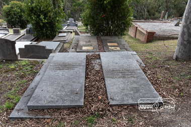
Photograph, Peter Pidgeon, Reynolds family grave, Eltham Cemetery, Victoria, 5 April 2021
Ernest Richard Reynolds was born June 1877, the son of Richard Reynolds and Sophia Allen. He married Elsie Mary Prior in 1913, the daughter of Thomas John Prior and Keziah Nutt. Ernest and Elsie had three children: Margaret Winifred (1914), Richard John (1915) and Ivy Beatrice (1917). The Reynolds family home was located at what is now 106 Thompson Crescent near the corner of Reynolds Road and Main Road. Reynolds Road was named after the family. Many historic photos of the district which now form part of the Reynolds/Prior and Shire of Eltham Pioneers Photograph collections were taken by Elsie’s brother, Henry Thomas (Tom) Edmond Prior and give a fine overview of many of the landmarks of Research and Eltham over 100 years ago. He was very innovative and made his own camera, using the black cloth hood to exclude the light. In Loving Memory Of Ernest Richard Reynolds Died 11th Oct 1960 Aged 83 yrs Elsie Mary Reynolds Died 2. 6. 89 Aged 98 years and In Loving Memory Of Margaret Winifred Reynolds Died 29. 12. 95 Aged 80 years Ivy Beatrice Reynolds Died 7 October 2011 Aged 94 years In His Loving CareBorn Digitaleltham cemetery, gravestones, elsie mary reynolds, ernest richard reynolds, ivy beatrice reynolds, margaret winifred reynolds -
 Eltham District Historical Society Inc
Document - Folder, Wellers of Kangaroo Ground, 1984-2017
Wellers of Kangaroo Ground Vertical File Contents: 1. Article: History of Wellers Restaurant by Sandra Cahir, revised 2017. 7 pages 2. Article: Weller’s Hotel of Kangaroo Ground (final draft) by Jim Allan, 1 June 2017, including feedback email from Sandra Cahir (7 May 2017). 3. Printout of online image - Kangaroo Ground landholders from 1841, Kangaroo Ground Presbyterian Church. (2022, June 29). Retrieved from https://kgpc.pcvic.org.au/images/history_images/Kangaroo-Ground-landholders.jpg 4. Folder of printouts of historical newspaper articles referencing the hotel 1866-1911 https://trove.nla.gov.au/list/163201 5. Printouts (various versions) from Victorian Heritage Database (National Trust and Nillumbik Shire) https://vhd.heritagecouncil.vic.gov.au/ 6. Collection of research notes, copies of records from various publications including EDHS Chronology of Events and Kangaroo Ground: The Highland Taken by Mick Woiwod, pp90, 180-181 (EDHS_01618). 7. Report: Request for ministerial amendment to use the property as a restaurant, includes existing conditions and plan for development, 1 November 1984 8. Papers donated by Diana and Peter Bassett-Smith including: a. Photocopy of Weller’s Hotel, Licensee M. Weller b. Letter: Shire of Eltham to Office of the Secretary for Planning and Environment, 23 Feb 1984 - Information regarding inclusion of Wellers Hotel into the Historic Buildings Register c. Letter: Historic Buildings Council letter to Peter Bassett-Smith seeking historical information on Wellers Hotel, 10 Jan 1985 d. Memo: Peter Bassett-Smith to Robert N. Hendrey on history of Wellers Hotel, 28 Jan 1985 - Includes extract of information about Mary Weller, Dept. of Crown Lands and Survey Map NILLUMBIK showing properties of John Weller and E. Weller and a Diamond Valley News article from 10 April 1973, p11, "Eltham on old coach route" 9. Information about the Weller family including family trees from various sources a. Edward Weller, Pioneer Families in Victoria, http://mepnab.netau.net/w/w09.html, 1 Jan 2017 (link broken) b. The WELLER family tree. (2017, January 1), 2 pages. Retrieved from https://www.weller.org.uk/cgi-bin/FamilyTree/ShowFamily.pl? and 27 pages Retrieved from https://www.weller.org.uk/cgi-bin/FamilyTree/ShowFamily.pl?ListAllPeople=A c. Edward WELLER on the WELLER family tree. (2017, January 1), 1 page. Retrieved from https://www.weller.org.uk/cgi-bin/FamilyTree/ShowFamily.pl?PersonID=516 d. Photograph (print copy), believed to be Edward Weller, 1836-1883 e. Photograph (print copy), Gravestone of Weller family at Kangaroo Cemetery f. Wellers of Kangaroo Ground, 1 page, possibly from History, http://www.wellers.com.au (broken) c.2016 g. Edward and Mary Weller miscellaneous biographical research notes (by Jim Allen?) including from Ancestry.com, and extracts from Chappel file (EDHS_04448) with relevant names highlighted h. Information about the Vernon Pitman family from Ancestry.com 10. Newspaper articles: a. Cobb & Co called here by Marguerite Marshall; Diamond Valley News, May 4, 1982, p2 b. Rich is history, 30 August 1983 (very similar to previous article) c. Weller’s Pub - restaurant, craft store or art gallery? Diamond Valley News, October 22, 1985, p3 d. Despite years of neglect a magical charm lies waiting, Diamond Valley News, October 29, 1985 e. Old pub fate still in doubt, Diamond Valley News, (?) 29 October 1985 f. Renovated Weller’s Pub to begin its new stage of life, DVN 26 January 1988 g. Wellers Restaurant, Lynne Hillier, Network, October 1988, p14 h. Revolution at Wellers, Nillumbik Mail, December 20, 2000 i. Wellers brings on good times, Valley Weekly, June 22, 2005 j. Dine in with ideal outlook, Valley News, 10 August 2005 k. Advertisement: Wellers of Kangaroo Ground, Enjoy lunch, afternoon tea and dinner at Wellers from Tuesday to Sunday, Valley Weekly, Wednesday, August 31, 2005 l. Advertisement: Wellers of Kangaroo Ground, Appearing live; Normie Rowe Fri 24 Feb, Diamond Valley Leader February 22, 2006, p11 m. Advertisement: Wellers of Kangaroo Ground, Lunch Special, Diamond Valley Leader March 27, 2010 n. Braithwaite abounds to Kangaroo Ground, Gig Guide, The Age, Friday, October 8, 2010, p14 o. History up for grabs, Diamond Valley Leader, March 28, 2012 p. Advertisement: Wellers Restaurant, Freehold only for sale, Morrison Kleeman, Diamond Valley Leader, March 28, 2012 q. Restaurant’s crash course, Megan Bailey, Diamond Valley Leader, January 1, 2014, p3. Also accessible online - Staff praised after car crashes through Kangaroo Ground eatery. (2022, June 29). Retrieved from https://www.heraldsun.com.au/leader/north/staff-praised-after-car-crashes-through-kangaroo-ground-eatery/news-story/021c896a1ab6d76bd6b73f2e57dc1854 r. Eatery set for revival, Brittany Shanahan, Diamond Valley Leader 15 February 2017; Also, online as Much-loved Wellers of Kangaroo Ground to be relaunched as Italian restaurant Fondata 1872. (2022, June 29). Retrieved from https://www.heraldsun.com.au/leader/north/muchloved-wellers-in-kangaroo-ground-to-be-relaunched-as-italian-restaurant-fondata-1872/news-story/665777fb347584ef483867ae2b536a8f s. Fondata 1872 proves a big hit with food, Diamond Valley Leader 3 May 2017, p3 11. Wellers of Kangaroo Restaurant Bar Entertainment Functions, tri-fold brochure promotional brochure 12. Website Printout: Wellers Restaurant, Live Guide, (2017, January 5). Retrieved from http://www.liveguide.com.au/Restaurants_Bars/VIC/Kangaroo_Ground/Food_Styles/3... 13. Website Printout: Wellers of Kangaroo Ground, Only Melbourne (2017, January 30). Retrieved from http://www.onlymelbourne.com.au/wellers-of-kangaroo-ground 14. Printouts from Fondata 1872 website and Facebook page including colour photograph of sign in front and business card (2017). Related EDHS Collection items • Wellers Hotel of Kangaroo Ground by Jim Allen, Part 1, Newsletter No. 235, Eltham District Historical Society, August 2017. Retrieved from https://elthamhistory.files.wordpress.com/2017/08/edhs-nl-235-aug-2017.pdf • Wellers Hotel of Kangaroo Ground by Jim Allen, Part 2, Newsletter No. 236, Eltham District Historical Society, October 2017. Retrieved from https://elthamhistory.files.wordpress.com/2017/10/edhs-nl-236-oct-2017.pdf • EDHS_03997 - Slide, Wellers Hotel, Pitmans Corner, Eltham-Yarra Glen Road, Kangaroo Ground, c.1975 https://victoriancollections.net.au/items/5e59e36221ea671798ac40eb • EDHS_03998 - Slide, Wellers Hotel, Pitmans Corner, Eltham-Yarra Glen Road, Kangaroo Ground, c.1975 https://victoriancollections.net.au/items/5e59e39e21ea671798ac9c27 • EDHS_03999 - Slide, Wellers Hotel, Pitmans Corner, Eltham-Yarra Glen Road, Kangaroo Ground, c.1975 https://victoriancollections.net.au/items/5e59e3c721ea671798acd2ef • EDHS_04000 - Slide, Wellers Hotel, Pitmans Corner, Eltham-Yarra Glen Road, Kangaroo Ground, c.1975 https://victoriancollections.net.au/items/5e59e3e021ea671798acfd68 • EDHS_04066-18 - Photograph, Wellers Restaurant, Eltham-Yarra Glen Road, Kangaroo Ground, c.Mar. 1989 https://victoriancollections.net.au/items/610f4dafa346aadcee7ac79c • EDHS_04041-26 - Photograph, Wellers Restaurant, 150 Eltham-Yarra Glen Road, Kangaroo Ground, c.May 1988 https://victoriancollections.net.au/items/610e2f4a7d65e7c945a35e69 • EDHS_04437 – Newsclipping, Renovated Weller's Pub to begin its new stage of life by Linley Hartley, Diamond Valley News, 26 January 1988 https://victoriancollections.net.au/items/5de4913921ea6710a46a85c7 • EDHS_04438 - Newsclipping, Wellers Restaurant by Lynne Hillier, Network, October 1988, p14 https://victoriancollections.net.au/items/5de4916f21ea6710a46aea0f • ArtStreams magazine (from Volume 9, 2004) ‘partnered' with Wellers in promoting and supporting the arts and culture. Various advertisements throughout, particular with live performance acts. Numerous references throughout to art and music performances on site. • Stephen Cummings and Joe Camilleri at Wellers Kangaroo Ground, ArtStreams, Vol. 9, No. 4, Sep/Oct 2004, p17 EDHS_04406 - Journal, ArtStreams: Whittlesea, Banyule, Darebin, Manningham, Nillumbik, Yarra; Vol. 9, No. 4, Sep-Oct 2004 https://victoriancollections.net.au/items/5bcc086021ea6804a82a92a9 • Daryl Braithwaite rocks up at Wellers, Fiona Sievers, ArtStreams, Vol.10 No.2, 2005, pp6-7 EDHS_04409 - Journal, ArtStreams: Vol. 10, No. 2, 2005 https://victoriancollections.net.au/items/60f5416ab06f0c13a9419541 • Ephemeral Sculpture by Peter Dougherty, ArtStreams, Vol.10 No.3, 2005, pp7-9. About sculptures created in or on the grounds of culinary establishments throughout the Shire. - Denise Keele-Bedford constructed ‘Ou Well’ at Wellers Restaurant and Vicky Shukuroglou, also at Wellers set up cotton banners printed and painted with natural dyes from onion skins, spinach, radish beetroot, turmeric and charcoal. EDHS_04410 - Journal, ArtStreams: Vol. 10, No. 3, 2005 https://victoriancollections.net.au/items/60f5436db06f0c13a941ae19 • Music at Wellers Restaurant, ArtStreams, Vol.10 No.4, 2005, p23 EDHS_04411 - Journal, ArtStreams: Vol. 10, No. 4, 2005 https://victoriancollections.net.au/items/60f543e4b06f0c13a941b059 • Weller’s Pub, Diamond Valley sketchbook / text by Brian McKinlay ; drawings by Graham Hawley, 1973, pp42-43 EDHS_00856 - https://victoriancollections.net.au/items/590852edd0ce7b14e8177da3 • Gold Field Coaches Stopped Here, Nillumbik now and then / Marguerite Marshall; photographs Alan King with Marguerite Marshall, 2008, pp86-87 EDHS_00977 - https://victoriancollections.net.au/items/5935f315d0cdd42c80f9cc52 External Links: • Historic Kangaroo Ground venue comes up for rare sale. (2022, June 29). Retrieved from https://www.smh.com.au/business/companies/historic-kangaroo-ground-venue-comes-up-for-rare-sale-20120325-1vshw.html • Wellers, Kangaroo Ground property sold with leaseback. (2022, June 29). Retrieved from https://www.urban.com.au/expert-insights/investing/37735-wellers-kangaroo-ground-property-sold-with-leaseback • Wellers, Kangaroo Ground | With Mark Seymour, at one of his …. (2022, June 29). Retrieved from https://www.flickr.com/photos/robertmilesdesign/4564390893/ • 2016 Notice of proposed deregistration - WELLERS OF KANGAROO GROUND PTY LTD 124 435 409. (2022, June 29). Retrieved from https://publishednotices.asic.gov.au/browsesearch-notices/notice-details/WELLERS-OF-KANGAROO-GROUND-PTY-LTD-124435409/35d43b89-159a-4435-963f-daec688a61ca • Search results for: Websites (archived). (2022, June 29). Retrieved from https://trove.nla.gov.au/search/category/websites?keyword=%22wellers%20restaurant%22 29 June 2022 edward weller, wellers of kangaroo ground, wellers hotel, wellers restaurant, mary weller, pittmans corner, fondata 1812 at wellers, historic buildings register, hotels, john weller, kangaroo ground, pitman's corner, bassett-smith collection -
 Eltham District Historical Society Inc
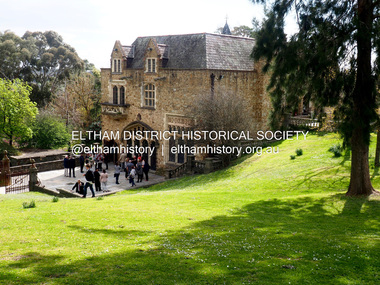
Photograph - Digital Photograph, Jim Connor, Eltham Cemetery Trust's launch at Montsalvat of Our Eltham - Artistic Recollections, 21 September 2017
Our Eltham - Artistic Recollections by Jim Connor, EDHS newsletter No. 236 October 2017 The Eltham Cemetery Trust, established in 1858, selected the existing burial site at Mount Pleasant Road on high ground overlooking the village of Eltham. The first recorded burial took place in 1861 in the Church of England section. Headstones depict the names of many early and well known local families. In recent years the Trust has encouraged the use of creative artistic elements within the natural bushland environment in their landscaped grounds adjoining Montsalvat. Their ongoing vision has been to offer the local communty a fresh and unique relationship to the Cemetery. On Thursday 21st September 2017 their latest commissioned art project titled ‘Our Eltham - Artistic Recollections’ was unveiled. It is a collection of panels collaboratively created by artist Nerina Lascelles and ceramicist Linda Detoma. The project was designed and constructed by Leigh Wykes using Australian stone with ironwork by Neil Carter. All contributors to this installation, located adjacent to the car park near Metery Road, are residents of the Eltham area. Our Eltham - Artistic Recollections is described as a celebration of life in the Shire since the opening of the Eltham Cemetery more than 150 years ago. Depicting scenes of life in and around Eltham, the collection offers deeper connections to the Eltham area through a series of visual narratives of Eltham’s past, environment and community. The project involves the artistic interpretation by Nerina Lascelles of historic and current images symbolically intermixed with locally indigenous flowers and plants. These are displayed on thirty-one ceramic panels by Linda Detoma, mounted within an iron fence by Neil Carter, upon an attractive rock wall constructed by Leigh Wykes. The Eltham District Historical Society is pleased to have contributed to this project. Russell Yeoman and Jim Connor from our Society have collaborated with Liz Pidgeon, Local and Family History Librarian at Yarra Plenty Regional Library on a selection of photographs, many from the Shire of Eltham Pioneers Collection we hold in partnership, located at Eltham Library. We also provided information on the images chosen. The Eltham Cemetery Trust has produced a booklet about this artwork, which can be viewed on the Cemetery website at: http://www.elthamcemetery.com/oureltham/#1 Our Eltham - Artistic Recollections is a significant monumental installation, which will encourage visitors to come to view this outstanding combination of local creative skills, set within the attractive grounds of the Eltham Cemetery. jim connor collection, eltham cemetery trust, montsalvat, our eltham artistic recollections, 2017-09-21 -
 Eltham District Historical Society Inc
Photograph, Fay Bridge, EDHS Heritage Excursion, Edendale Farm, 5 May 2018
May Excursion – Edendale Environs Edendale Community Environment Farm in Gastons Road, Eltham now operates as Nillumbik Council’s environmental centre. The historic homestead has undergone a significant restoration and there is on-going development of the site consistent with its community education purpose. The house and the gateway sculpture “The Fences Act” are covered by a Heritage Overlay in the Nillumbik Planning Scheme. Our May excursion will comprise a walk through the farm property and will radiate to other nearby places of historic interest. These will include the site of the Eltham North Adventure Playground to discuss its history and destruction by fire (see page 1 article). Also nearby is Colemans Corner where the early road system has undergone some unusual changes. If time permits we may visit some other nearby places of interest. - EDHS Newsletter No. 239 April 2018fay bridge collection, 2018-05-05, edendale community farm, edendale farm, eltham district historical society, heritage excursion, activities -
 Eltham District Historical Society Inc
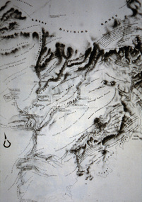
Slide - Photograph, Old map of Diamond Creek catchment, c.Sep. 1989
Part of a slide show presentation "Bridges & Waterways of the Shire" by Russell Yeoman to the 13 September 1989 Society meeting. The presentation included slides of historic photos from the Shire of Eltham Pioneers collections as well as several recent views.35mm colour positive transparency (1 of 33) Mount - Agfa CS System grey 8 dotsProcess Date Sep 1989diamond creek catchment, map -
 Eltham District Historical Society Inc
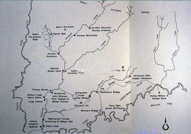
Slide - Photograph, Pastoral Runs, Diamond Creek Catchment, c.Sep. 1989
Part of a slide show presentation "Bridges & Waterways of the Shire" by Russell Yeoman to the 13 September 1989 Society meeting. The presentation included slides of historic photos from the Shire of Eltham Pioneers collections as well as several recent views.35mm colour positive transparency (1 of 33) Mount - Agfa CS System grey 8 dotsProcess Date Sep 1989diamond creek catchment, map, pastoral runs -
 Eltham District Historical Society Inc
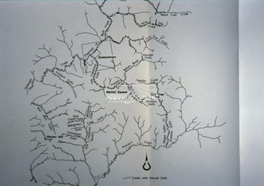
Slide - Photograph, Creeks with Alluvial gold, St Andrews, c.Sep. 1989
Part of a slide show presentation "Bridges & Waterways of the Shire" by Russell Yeoman to the 13 September 1989 Society meeting. The presentation included slides of historic photos from the Shire of Eltham Pioneers collections as well as several recent views.35mm colour positive transparency (1 of 33) Mount - Agfa CS System grey 8 dotsProcess Date Sep 1989map, creeks, alluvial gold, st andrews -
 Eltham District Historical Society Inc
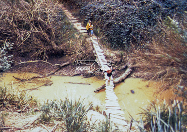
Slide - Photograph, Old footbridge, Gum Glade, Eltham, c.Sep. 1989
Part of a slide show presentation "Bridges & Waterways of the Shire" by Russell Yeoman to the 13 September 1989 Society meeting. The presentation included slides of historic photos from the Shire of Eltham Pioneers collections as well as several recent views.35mm colour positive transparency (1 of 33) Mount - Agfa CS System grey 8 dotsProcess Date Sep 1989old footbridge, gum glade, eltham, diamond creek (creek) -
 Eltham District Historical Society Inc
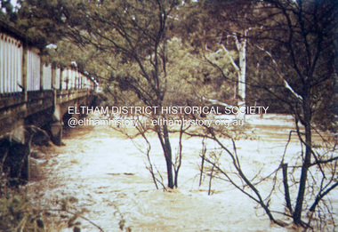
Slide - Photograph, 1934 flood, Eltham South, c.Sep. 1989
Part of a slide show presentation "Bridges & Waterways of the Shire" by Russell Yeoman to the 13 September 1989 Society meeting. The presentation included slides of historic photos from the Shire of Eltham Pioneers collections as well as several recent views.35mm colour positive transparency (1 of 33) Mount - Agfa CS System grey 8 dotsProcess Date Sep 1989eltham, diamond creek (creek), 1934 flood, eltham south, main road bridge -
 Eltham District Historical Society Inc
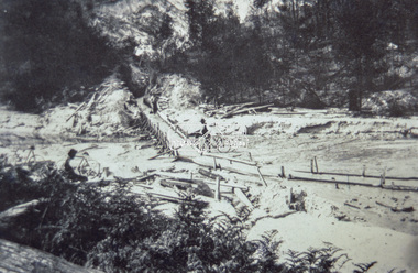
Slide - Photograph, Sluicing Race, St Andrews, c.Sep. 1989
Part of a slide show presentation "Bridges & Waterways of the Shire" by Russell Yeoman to the 13 September 1989 Society meeting. The presentation included slides of historic photos from the Shire of Eltham Pioneers collections as well as several recent views.35mm colour positive transparency (1 of 33) Mount - Agfa CS System grey 8 dotsProcess Date Sep 1989sluicing race, st andrews