Showing 4508 items
matching original collection
-
 Warrnambool and District Historical Society Inc.
Documents, The Valentine & Sons Publishing Co Ltd, Letter and postcards: Orford Critchlow to Gladys Holmes, pre 1917
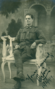
Gladys Holmes born 1897, Byaduk, eldest daughter of Joseph (Baker) and Agnes Homes. She married Alexander George Henderson in 1924. James Orford Critchlow born 26/08/1896. He enlisted in Casterton, Victoria on 26/08/1916. The Nominal AIF Roll indicates he was a clerk, single, son of James Critchlow and Cof E and a Gunner 33322. in 1924 he married Brice Violet Payne in Victoria. His death is recorded in New South wales on 15/08/1962 with probate granted 06/12/1962.Original documents sent by James Orford Critchlow, Gunner 33322 abroad to Gladys Holmes of Bydauk during WW1, 1917 to 1919. Part of 14 sets of items forming the Gladys Holmes collection.1808.1 Sepia photograph 1808.2 Colour, child holding two pot plants and basket of flowers 1808.3 Embroidered floral envelope in a white mount with small card inside 1808.4 Embroidered 'Forget Me Not' scene in white mount 1808.5 Black and white photograph of Town hall and Gardens, Durban 1808.6 Through the Pines, Kloof Road 1808.7 Embroidered flower, small, in pink mount with gold text 001808.08-001800.8.12; Letter, 5 pages 1808.1 Yours sincerely/Orford/15/2/1919, on reverse note Dear Gladys...Yours sincerely 1808.2 Reverse 'a Fraire/Belgique/Janvier 29th 1919, note Dear Gladys...from yours sincerely Orford 1808.3 Revers: Gladys...from Orford/France/23/10/1918, Insert- Front-Merry/Christmas/from/France; Revers- Gladys/from/Orford/Longpre, France/28/10/1918/Heaps of good luck 1808.4 Front- Forget Me Not, reverse-Gladys/with best wishes/from Orford/France/20/1/1918 1808.5 Reverse- Dear Gladys..Yours sincerely/Orford and address 1808.6 Reverse- 20/5/1917,At Sea/SS Shropshire, Dear Gladys..Yours sincerely Orford 1808.7 Reverse- Dear Gladys..from Orford Critchlow 001800.8-001808.12R: Letter on Y.M.C.A. letterhead paper, written on both sides of 5 pages. Boyton,1/8/1917-1/9/1917/Dear Gladys.... Yours sincerely Orfordgladys holmes, james orford critchlow, letter, photograph, postcards, ww 1, byaduk, casterton, belgium, embroidery, france, 4th battery, australian field artillery, durban, ss shropshire, the valentine & sons publishing co ltd -
 Warrnambool and District Historical Society Inc.
Correspondence – Louis Buvelot, 1889-1897
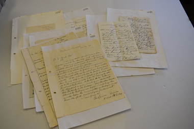
One of these items is an 1894 letter written by the artist Tudor St George Tucker regarding one of his artworks in the Warrnambool Art Gallery collection. The other eight letters were written between 1889 and 1897 and document the controversy of the time when the authenticity of the art work by Louis Buvelot, The Waterhole at Coleraine, in the Warrnambool Art Gallery collection, was questioned. The Warrnambool photographer Daniel Clarke was querying the authenticity of the art work in the Art Gallery but evidence in the form of letters from George Folingsby of the National Gallery in Melbourne and from Louis Buvelot’s widow, Caroline-Julie, confirmed that there was confusion over the number of art works that Buvelot had executed with a similar theme. It was eventually proven that the Buvelot art work was genuine. The public spat was largely played out in the Warrnambool Standard but these original letters fill in the gaps of our knowledge on the subject. The letters came into the possession of George Lance who was involved with the Warrnambool Mechanics Institute /Art Gallery in the 1880s and 1890s and was the secretary of these institutions from 1892 to 1901. The letters were then handed on George Lance’s grandson, Bruce Morris, a well-known Warrnambool historian who was the editor of the Warrnambool Standard from 1946 to 1968. These letters are of great significance as eight of them are the original letters written in connection with the 19th century controversy in Warrnambool over the authenticity of a Louis Buvelot art work owned by the Warrnambool Art gallery. .1 A sheet of paper folded in two containing three pages of writing handwritten in black ink and pasted on paper. .2 A sheet of paper folded in two containing one page of writing handwritten in black ink and pasted on a sheet of paper. .3 A sheet of paper with handwriting in black ink pasted on a piece of paper. .4 One sheet of paper folded in two to make four pages of writing, handwritten in black ink. .5 .6 .7 A sheet of paper with handwritten material in black ink pasted onto another sheet of paper .8 A sheet of paper folded in two with three pages of handwritten material pasted onto another sheet of paper. .9 A sheet of paper folded in two with one page of handwritten material pasted onto another sheet of paper. tudor st. george tucker, artist, louis buvelot, artist, george lance, warrnambool, daniel clarke, warrnambool, george folinsby, melbourne, history of warrnambool -
 Port of Echuca
Black and white photograph, approx. 1980
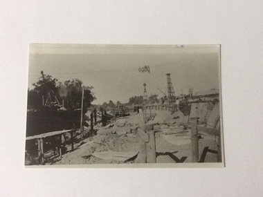
Black and white photograph showing construction of Lock 7 possibly near Renmark. Amongst the equipment are several gantry cranes and structural timbers. Also shows the way the river was blocked off to enable works to be constructed. Copy of original photograph.Historically significant showing the construction of locks on the Murray river. Use of gantry cranes.Black and white photograph showing construction of Lock 7 possibly near Renmark. Amongst the equipment are several gantry cranes. Copy of original photograph.In pencil on back "Construction of Lock 7 (near?) Renmark". "A. J. Gibbons, photo" . "Price"murray river, lock construction, gantry cranes, price collection -
 Port of Echuca
Black and white photograph, approx 1980
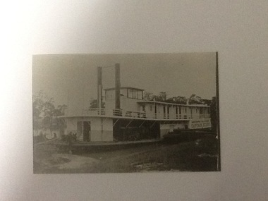
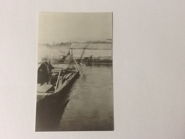
A closeup, black & white photo of the P.S. Captain Sturt moored by river bank. Captain Sturt is a two-funnelled, two storey boat with the wheelhouse above the 2nd storey. It appears the second storey is cabins. The original photo is part of the Price Collection.Black and white copy of a photograph of P. S. Captain Sturt moored by river bank. Copy of an original photograph (unknown date)In black pencil "Price, Captain Sturt, date unknown -
 Port of Echuca
Black and white photograph, approx.1980
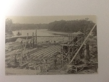
Construction of the Lock at Euston. An overhead crane is visible in the centre of the photo. In the foreground are 2 sets of low pylons. There is construction equipment visible on both sides of the photo. It is a dry river bed which appears to have a walled wooded end at the back of the photo.This is social and historically significant in that this photograph depicts the construction materials and techniques used at this time when constructing locks on the rivers in the Murray Darling region.Black and white photograph of construction work on Lock at Euston. Centre of photograph has an overhead crane. In the foreground are 2 sets of low phylons. Copy of an original photograph from the Price collection.In pencil on back: Price / Lock under construction / Euston / JENKINS PRINT/MILDURAmurray darling river basin, euston (lock construction), lock construction, price collection -
 Port of Echuca
Black and white photograph, Approx 1980
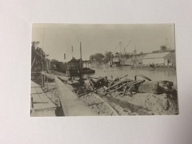
Scene depicted is believed to have been the Euston Lock. It shows various pieces of equipment in the foreground , with a pontoon names Bream on the left bank with a paddle steamer, sheds and cranes in the distance on the right hand side of the photograph. Original photograph from the Price collection. Historically and socially significant photograph depicting early 1920's life on the Murray river.Black and white photograph of river scene depicting , by the left bank a pontoon "Bream" and by the right bank a steamboat behind a shelter construction. There are various cranes on the right bank. Copy of an original photograph taken in the 1920s believed to at Euston Lock, N.S.W.In pencil on back: Price / believed to be Euston Lock.riverboats, paddle steamers, price collection -
 Port of Echuca
Black and white photograph, Approx. 1980
Black and white photograph of an unknown lock scene where 3 men are working from a hollow platform structure, with one person being a diver coming up or going down a ladder. Another person appears to have hold of a hose (could be oxygen) and the back view of the other person appears to be working with them watching what is happening. This could be part of lock construction as there appears to be cranes and a tripod in the distance.This black and white photograph demonstrates historical and social significance in that it gives a close up view of workmen in the process of lock construction. It appears that there is a diver suited up with helmet on, descending the ladder and a person holding what appears to be hose connected to the person diving. This scene is possibly from the beginning of the 20th century and could be about the development of the irrigation industry.Black and white photograph , portrait format, of 3 men on a hollow platform structure in a river. One man is a diver and is on a ladder which steps down into the water. Copy of an original photograph. On reverse in pencil: Price, Lock scene, location Unknown. lock scene, lock construction, price family collection, irrigation industry -
 Warrnambool and District Historical Society Inc.
Magazines, 1 W.D. James & Co .2 H.J. Paynter & Co, The Link, Early 1920s
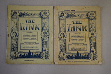
These magazines originally belonged to Catherine Mary Stewart who taught at Penshurst State School. She was the grandmother of the donor of the two magazines. These magazines were produced in the 1920s by the inspectorate of the Warrnambool district schools and they featured contributions by the pupils and teachers from the schools in the area. The magazine, ‘The Link’ was first published in September 1921 and came out once or twice a year in the early 1920s. In 1924 the magazine had a circulation of 1500 covering 107 State Schools, one Technical School, one High School, two Higher Elementary Schools and 17 registered schools. The contributions from the pupils are of special interest today as many of the names later became important locally and some of the photographs are of interest as they are ones not in local collections today. These magazines are of considerable importance as they contain many photographs not previously seen and much original material (articles, poems etc) produced by pupils and teachers in the Western District of Victoria in the early 1920s. They are of value to researchers. .1 A soft cover booklet of 42 pages. The booklet is stapled. The cover is buff-coloured with blue printing and it has images of children, schools, sporting equipment, technical classes and other decorative material. The booklet contains printed material, black and white photographs and advertisements. .2 as above except that there are 72 pages and a different publication date education in the western district, “the link” schools magazine, history of warrnambool -
 Warrnambool and District Historical Society Inc.
Administrative record - Account cards, 1920s and 30s
These cards have been used as an accounting system by the Warrnambool firm of J. Mainland and Co. This firm of watchmakers, opticians and manufacturing jewellers was established in Liebig Street in the late 1890s and continued on into the 20th century at 166 Timor Street. The cards date from the 1920s and 30s. It is noted that in 1932 one customer purchased a Clarice Cliff ash tray for six shillings and sixpenceThese cards are of considerable interest firstly they give us some details of the many customers of the Warrnambool jewellery firm of J. Mainland and Co and secondly because they provide us with much information on a great number of residents of Warrnambool and district in the 1920s and 30s (addresses etc)This is a collection of paper invoices, some original, some copied, with some in alphabetical order and some in number order. The invoices are separated by pieces of cardboard with either numbers or letters on the front. The collection is only portion of a larger set of cards. The invoices were originally held together by small pins.warrnambool jewellery stores -
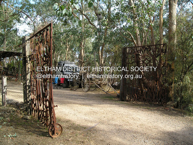
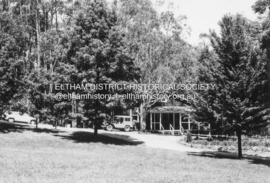
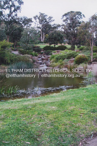 Eltham District Historical Society Inc
Photograph, Fay Bridge, Lake, Eltham Cemetery, 40 Mount Pleasant Road, Eltham, c.2009
Robert Boyle Landscape Design created the original design and construction of the lake in 1993. They are renowned local landscape designers and have carried out numerous projects at the Cemetery, including the major upgrades to the lakeside design in 2020. Title Lakeside Maintenance and Improvement Works Url https://www.elthamcemetery.com/item/25-lakeside-maintenance-and-improvement-works Description Improvement works to the lake and surrounding area July to October 2020.fay bridge collection, 2009, eltham, eltham cemetery, lake, mount pleasant road -
 Eltham District Historical Society Inc
Photograph, Fay Bridge, EDHS Heritage Walk: Shillinglaw Farm, Eltham, 2 September 2023
On Saturday September 2, 2023, Russell Yeoman led a group of 22 society members and interested others on a walk following trhe bounadries of the original Shillingalw farm. Commencing at the corner of Panther Place and Library Place, we proceeded up to Shillinglaw Cafe then the Shillinglaw trees at the former Eltham Shire Office site then along Main Road to the fire station then throughh St Laurence Lane and uinder the railway line , along Diamond Street then return via the Diamond Creek trail behind Andrew Park. The actual farm boundary went past the creek and further up the hill. The original farm comprised lot 90 of Holloway’s 1851 subdivision of Little Eltham. Its area was 30 acres lying east of the Diamond Creek and north of Henry Street. A number of stops were made to look at maps and early photos illustrating the gradual reduction of the farm area and the early history of the railway and other community uses, that occupied parts of the site.fay bridge collection, 2023-09-02, activities, eltham, eltham district historical society, heritage excursion, shillinglaw farm -
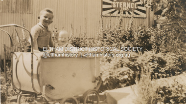 Eltham District Historical Society Inc
Photograph, Kenneth Albert Ingram and Pam Ingram (in pram) in front of house at Research next to service garage, c.1943
Kenneth Douglas Ingram's Shell service garage (in background) was located between the family home and the public hall at Research on the original line of Main Road. The public hall site is now the site of the Eltham Little Theatre. The family home (behind photographer), a red brick building still stands today (2023) at 1591 Main Road, Researchpam thoonen (nee ingram) collection, k.d. ingram shell garage, kenneth albert ingram, kenneth douglas ingram, main road, pamela lorraine ingram, research (vic.), research garage -
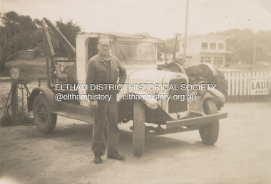 Eltham District Historical Society Inc
Photograph, Kenneth Douglas Ingram with his tow truck at Anglesea, c.1950
Kenneth Douglas Ingram was a motor mechanic. He ran a Shell garage at Research, Victoria on the original line of Main Road, situated next to the Research Public Hall. When his parents moved to Anglesea, he established the Ocean Road Service Station (affiliated with Mobil Oil) in Anglesea with his own tow truck. anglesea, pam thoonen (nee ingram) collection, kenneth douglas ingram, tow truck -
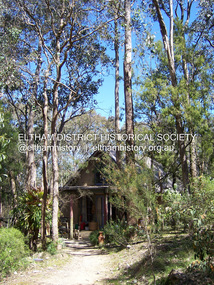 Eltham District Historical Society Inc
Photograph - Digital Photograph, Marguerite Marshall, Neil Douglas house, Bend Of Islands, 3 October 2006
Mud brick house first owned by naturalist and artist Neil Douglas and Helen (Abbie) Heathcote at the Bend of Islands. They were original residents in the 1970s. This house is on the Victorian Heritage Database and is considered locally significant. Covered under Heritage Overlay, Nillumbik Planning Scheme Published: Nillumbik Now and Then / Marguerite Marshall 2008; photographs Alan King with Marguerite Marshall.; CoverThis collection of almost 130 photos about places and people within the Shire of Nillumbik, an urban and rural municipality in Melbourne's north, contributes to an understanding of the history of the Shire. Published in 2008 immediately prior to the Black Saturday bushfires of February 7, 2009, it documents sites that were impacted, and in some cases destroyed by the fires. It includes photographs taken especially for the publication, creating a unique time capsule representing the Shire in the early 21st century. It remains the most recent comprehenesive publication devoted to the Shire's history connecting local residents to the past. nillumbik now and then (marshall-king) collection, bend of islands, neil douglas house, neil douglas -
 Eltham District Historical Society Inc
Photograph - Digital Photograph, Alan King, The barn at Culla Hill, Sweeneys Lane, Eltham, 30 January 2008
The barn of former convict Thomas Sweeney at Culla Hill remains almost in its original condition. Published: Nillumbik Now and Then / Marguerite Marshall 2008; photographs Alan King with Marguerite Marshall.; p19This collection of almost 130 photos about places and people within the Shire of Nillumbik, an urban and rural municipality in Melbourne's north, contributes to an understanding of the history of the Shire. Published in 2008 immediately prior to the Black Saturday bushfires of February 7, 2009, it documents sites that were impacted, and in some cases destroyed by the fires. It includes photographs taken especially for the publication, creating a unique time capsule representing the Shire in the early 21st century. It remains the most recent comprehenesive publication devoted to the Shire's history connecting local residents to the past. nillumbik now and then (marshall-king) collection, culla hill, eltham, sweeney's cottage, sweeneys lane -
 Eltham District Historical Society Inc
Photograph - Digital Photograph, Alan King, Original Kangaroo Ground Primary School No. 2105 building, Eltham-Yarra Glen Road, Kangaroo Ground, 28 December 2007
Kangaroo Ground's first school began in 1851 with 22 pupils from the district's ten families. It was a single room school located further south on the site, which also served as a Presbyterian church. The first teacher was Andrew Ross. The school building was used as a Post Office between 1854 and 1858 and during 1857 also served as a Court of Petty Sessions. With a growing farming community, a new building was warranted and the original Sate School No. 352 was closed and a new building, State School No. 2105 was oipened October 1, 1878. A residence for Head Teacher Henry Wallace School was erected in 1879 attached to the left of the school building. That residence is now home to the Andrew Ross Museum, which opened in 1993. Covered under Heritage Overlay, Nillumbik Planning Scheme. Published: Nillumbik Now and Then / Marguerite Marshall 2008; photographs Alan King with Marguerite Marshall.; p35This collection of almost 130 photos about places and people within the Shire of Nillumbik, an urban and rural municipality in Melbourne's north, contributes to an understanding of the history of the Shire. Published in 2008 immediately prior to the Black Saturday bushfires of February 7, 2009, it documents sites that were impacted, and in some cases destroyed by the fires. It includes photographs taken especially for the publication, creating a unique time capsule representing the Shire in the early 21st century. It remains the most recent comprehenesive publication devoted to the Shire's history connecting local residents to the past. nillumbik now and then (marshall-king) collection, kangaroo ground, eltham-yarra glen road, kangaroo ground primary school no. 2105, kangaroo ground state school, state school no. 2105 -
 Eltham District Historical Society Inc
Photograph - Digital Photograph, Alan King, Eltham Hotel, cnr Main Road and Pitt Street, 28 December 2007
The Eltham Hotel is the oldest continually operating hotel in the Eltham district. Initially referred to as the Little Eltham Hotel, it has been known as the Eltham Hotel since the mid-1850s through to the present except for a brief period as the Eltham Tavern in the late 1980s. The original hotel opened in 1854 by Richard Warren was built by Benjamin Oliver Wallis. The Fountain of Friendship Hotel on the opposite side of Maria Street (Main Road) opened shortly after. The hotel was a well-known resting place for gold diggers during the gold rush at Woods’ Point and Warren would buy the gold from the diggers. Warren ran into financial difficulties and determined to return to England. Wallis bought the hotel in 1861 and ran it till 1886 when he sold it to Christopher Watson Snr. When Christopher Watson Snr died a year after purchase, his son Christopher took over until his death in 1909 when it passed to wife Emily and then their youngest son, Herbert James (Jim) Watson in 1915. In July 1925, Jim Watson demolished the original building and, in its place, erected a modern hotel which remains the foundation of the present-day Eltham Hotel. Covered under Heritage Overlay, Nillumbik Planning Scheme. Published: Nillumbik Now and Then / Marguerite Marshall 2008; photographs Alan King with Marguerite Marshall.; p41This collection of almost 130 photos about places and people within the Shire of Nillumbik, an urban and rural municipality in Melbourne's north, contributes to an understanding of the history of the Shire. Published in 2008 immediately prior to the Black Saturday bushfires of February 7, 2009, it documents sites that were impacted, and in some cases destroyed by the fires. It includes photographs taken especially for the publication, creating a unique time capsule representing the Shire in the early 21st century. It remains the most recent comprehenesive publication devoted to the Shire's history connecting local residents to the past. nillumbik now and then (marshall-king) collection, eltham, eltham hotel, main road, pitt street -
 Eltham District Historical Society Inc
Photograph - Digital Photograph, Alan King, St Margaret's Anglican Church, Pitt Street, Eltham, 30 January 2008
St Margaret’s Church of England was officially opened on December 12, 1861. It is the oldest intact church building in Eltham. At the time it was known as Christ Church until its consecration in 1871, when it was completely free of debt (£1,700 for the church and parsonage) despite the district’s poverty. This was largely due to the free labour and materials, including locally made bricks donated by local artisans and others. The church is historically significant because it is the oldest church in the former Shire of Eltham and has associations with the philanthropist and founder of Brighton, Henry Dendy (who donated the land on which the church is built), the architect Nathaniel Billing and the prominent local builder, George Stebbing. The church is architecturally and aesthetically significant because it is constructed in the Gothic Revival style with several stained-glass windows of various dates and is also a very early use of polychromatic brickwork in Victoria. Billing was one of the first Melbourne architects to employ polychromatic brickwork and an important early architect. The rear wall was intended to be temporary. A major feature of the design is the large buttresses with long, steeply graded upper faces. The overall design is well proportioned with the surface brick patterns relieving an otherwise austere design. The church is spiritually and socially significant because it has been an important place of worship for the people of Eltham for almost 150 years. The land on which the buildings stand was donated by Henry Dendy. Dendy arrived in Melbourne in 1841 after purchasing in England eight square miles at Brighton under the system of "special surveys". After this land passed out of his hands, Dendy moved about Victoria, visited England, then returned to settle in Eltham where he purchased a flour mill. Dendy chaired the meeting held in 1860 “for the purpose of devising such means as may be expedient for the establishment of a Church of England in the township of Eltham”. He became chairman and treasurer of the church committee. Unlike the establishment of many early churches in Victoria where a vicar was appointed to a parish and later a permanent church was constructed, the population at Eltham initiated action to build a church. The nearest church at that time was at Heidelberg and the Eltham settlement was part of the parish of St Johns Heidelberg. Isolation and the tedious, time consuming journey between Heidelberg and Eltham resulted in the Eltham community taking its own action. The original vicarage (Dendy House) at the rear of the church is also an important part of the cultural significance of this place because it is connected to the church and the development of the Eltham area. Together, the church and the vicarage are aesthetically significant because they form a significant streetscape feature. The mud-brick community hall designed by Robert Marshall was added in 1978. In 2014 the original temporary rear wall was removed as part of a modern extension designed by Architects Atelier Wagner and constructed by Conrad Construction and Management. Covered under Heritage Overlay, Nillumbik Planning Scheme. National Trust of Australia (Victoria) State significance Victorian Heritage Published: Nillumbik Now and Then / Marguerite Marshall 2008; photographs Alan King with Marguerite Marshall.; p67This collection of almost 130 photos about places and people within the Shire of Nillumbik, an urban and rural municipality in Melbourne's north, contributes to an understanding of the history of the Shire. Published in 2008 immediately prior to the Black Saturday bushfires of February 7, 2009, it documents sites that were impacted, and in some cases destroyed by the fires. It includes photographs taken especially for the publication, creating a unique time capsule representing the Shire in the early 21st century. It remains the most recent comprehenesive publication devoted to the Shire's history connecting local residents to the past. nillumbik now and then (marshall-king) collection, eltham, st margaret's anglican church, st margaret's church, christ church -
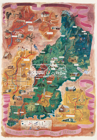 Eltham District Historical Society Inc
Map (item), Megan Evans, Cultural Heritage Map, Shire of Eltham, 1993
Copy of artist's map of the Shire of Eltham with numerous historical and cultural places of interest illustrated and notated including evidence of original Wurundjeri occupation and local flora and fauna. The original watercolour is held in the Nillumbik Shire Council Civic Collection. "Evans remembers being surprised they had asked an artist to create this map rather than a designer. Originally made as a watercolour, the map was later made into posters and adorned many homes around the area. The map creatively interprets the town and provides a wayfinding to both cultural and historical points in the area." Nillumbik Arts News December 2023. artist, buildings, cultural heritage map, fauna, flora, map, megan evans, shire of eltham, wurundjeri -
 Eltham District Historical Society Inc
Photograph - Digital Photograph, Alan King, Shire of Eltham War Memorial, Kangaroo Ground, 28 January 2008
... the removal of the original stone structure around the rooftop exit ...The Eltham Shire War Memorial, a tower of remembrance, was built with public donations to commemorate the memory of the fallen soldiers from the shire who enlisted in the 1914-1918 war. The tower is reminiscent of the peel-towers or watchtowers that lined the English-Scottish border from the mid 14th century to around 1600 and is constructed from locally quarried stone. This uncommon and picturesque war memorial, which affords an excellent view of the surrounding district was unveiled by His Excellency the Governor-General (Lord Stonehaven) on November 11, 1926. In July 1922 a deputation of returned soldiers from Panton Hill, presumably the Panton Hill branch of the Returned Sailors and Soldiers Imperial League of Australia (RSSILA), proposed to Eltham Shire Council that the monument should be a cairn of local stone “sufficiently high to form a prominent and conspicuous landmark, and crowned with some suitable device”. Eltham Shire Councillor and President of the Panton Hill branch of the RSSILA, Basil Hall, was credited with being the first to suggest a tower, and with organising a Memorial Park committee to raise funds for the monument in the Memorial Park. A meeting for those interested in the establishing a War Memorial monument in the park was held in January 1924 and the Eltham Shire War Memorial League was formed for this purpose. It appears that the broad and rounded cairn that had been recently built was considered by the League a temporary affair, and not the substantial cairn-as-monument, sufficiently high to form the conspicuous landmark, which had been envisaged by the Panton Hill RSSILA. A design competition was held for the monument. The chairman of the League, Councillor Basil Hall, suggested that the site of the memorial in Kangaroo Ground would lend itself to something rugged, instead of polished stone. By April 1924 thirty designs for a memorial had been received from which three designs were selected and of those, the design by the shire engineer Mr McCormack, for a 70ft tower suitable for construction in rough stone, was chosen. Artist Harold Herbert suggested that a peel tower-like design reminiscent of those along the English-Scottish border would be fitting for the site. Herbert drew up a rough sketch that was approved of, and later, Melbourne architect Percy Meldrum volunteered to draw up the design from sketch to architectural drawings. By January 1925 the Soldiers’ Memorial League had adopted Meldrum’s design for a 50ft high tower. Meldrum had also offered his design and supervision of construction free of charge. The Shire provided the stone to the builders, which was a gift quarried from land owned at Kangaroo Ground by Dr Ethel and Professor William Osborne The Shire of Eltham War Memorial, a tower of remembrance, and honour board were unveiled on November 11, 1926, by the Governor General Lord Stonehaven. At this stage a temporary honour roll was painted on the panels on either side of the tower entrance. In September 1930 bronze plates were added above the portal with the names of men who fell in the 1914-18 war. On November 16, 1951, the Governor of Victoria, Sir Dallas Brooks re-dedicated the war memorial tower and unveiled the names of men who gave their lives in the 1939-45 war. Two additional bronze plaques which recognise service in the armed conflicts of Korea, Borneo, Malaya, and Vietnam were unveiled November 11, 2001, by the Governor of Victoria, John Landy, A.C., M.B.E. The tower was first used for fire spotting activities following the Black Friday bushfire in January 1939 in response to a request from Mr R.D. Ness, secretary of the Kangaroo Ground bush fire brigade, who asked Council that the tower be used as an observation tower for detecting bush fires, and asked Council to arrange a telephone to be installed. It was suggested that if the Shire were to appoint a caretaker for the Memorial Park, his duties could also include raising the alarm in the event of a fire. Later in 1939 Council applied for a radio transmitter, which the Forestry Commission planned to install at vantage places throughout the state. The first dedicated fire spotter appointed from December1948, was Mr Smith of Warrandyte. A prefabricated glazed cabin was installed in 1974, which involved the removal of the original stone structure around the rooftop exit door. A new fire spotting cabin, which included the latest technology, was installed soon after the 2009 Black Saturday fires and is manned by CFA personnel on high fire danger days. Covered under Heritage Overlay, Nillumbik Planning Scheme. Published: Nillumbik Now and Then / Marguerite Marshall 2008; photographs Alan King with Marguerite Marshall.; p123This collection of almost 130 photos about places and people within the Shire of Nillumbik, an urban and rural municipality in Melbourne's north, contributes to an understanding of the history of the Shire. Published in 2008 immediately prior to the Black Saturday bushfires of February 7, 2009, it documents sites that were impacted, and in some cases destroyed by the fires. It includes photographs taken especially for the publication, creating a unique time capsule representing the Shire in the early 21st century. It remains the most recent comprehenesive publication devoted to the Shire's history connecting local residents to the past. While published in the book in black and white, this collection features the original colour digital photographs. nillumbik now and then (marshall-king) collection, garden hill, kangaroo ground, memorial park, shire of eltham war memorial -
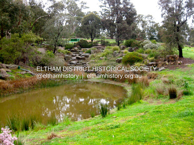 Eltham District Historical Society Inc
Photograph - Digital Photograph, Jim Connor, Lake, Eltham Cemetery, 40 Mount Pleasant Road, Eltham, 9 September 2009
Robert Boyle Landscape Design created the original design and construction of the lake in 1993. They are renowned local landscape designers and have carried out numerous projects at the Cemetery, including the major upgrades to the lakeside design in 2020.jim connor collection, eltham, eltham cemetery, lake, mount pleasant road -
 Eltham District Historical Society Inc
Photograph, Fay Bridge, Clifton Pugh's Artists' Colony, Dunmoochin, Barreenong Road, Cottles Bridge, c.1995
Visit to Dunmoochin prior to Clifton Pugh's home being destroyed by fire in 2002. Following military service in the second world war, Clifton Pugh studied under artist Sir William Dargie at the National Gallery School in Melbourne as well as Justus Jorgensen, founder of Montsalvat. For a while he lived on the dole but also worked packing eggs for the Belot family saving sufficient to purchase six acres (2.4 ha) of land at Barreenong Road, Cottles Bridge. He accumulated more land and persuaded several other artists and friends to buy land nearby, resulting in a property of approximately 200 acres, stablishing it as one of the first artistic communes in Australia alongside Montsalvat in Eltham. It was around 1951 that Pugh felt he had '"done moochin' around" and so the name of the property evolved. He bought timber from Alistair Knox to build his house on the crest of a hill. Inspired by local goldminer's huts, it was a one room wattle-and-daub structure with dirt floor. Over the years it expanded with thick adobe walls made from local clay, high ceilings and stone floors. All materials other than the local earth were sourced from second hand materials, most found at wreckers' yards. Artists from across the nation were drawn to Dunmoochin, with several setting up houses and shacks on the property, maintaining their independence but sharing their artistic zeal. Artists who worked or resided at Dunmoochin included Mirka Mora, John Perceval, Albert Tucker, Fred Williams, Charles Blackman, Arthur Boyd and John Olsen. In 2002, Pugh's house along with its treasure trove of art and a library of some 20,000 books was destroyed by fire. Traces of Pugh's home remain with the presence of the Victorian doorframe archway with leadlight of intricate design, procured from a demolished Melbourne mansion; and two bronze life-sized female statues created by Pugh and cast by Matcham Skipper. In place of Pugh's house rose two double-storey mud-brick artists' studios topped with corrugated iron rooves curved like the wings of a bird with accommodation for seven. The original studios, gallery and other buildings survived the fire.fay bridge collection, 1995, barreenong road, cottles bridge, dunmoochin -
 Eltham District Historical Society Inc
Photograph, Fay Bridge, Clifton Pugh's Artists' Colony, Dunmoochin, Barreenong Road, Cottles Bridge, 14 May 2016
Following military service in the second world war, Clifton Pugh studied under artist Sir William Dargie at the National Gallery School in Melbourne as well as Justus Jorgensen, founder of Montsalvat. For a while he lived on the dole but also worked packing eggs for the Belot family saving sufficient to purchase six acres (2.4 ha) of land at Barreenong Road, Cottles Bridge. He accumulated more land and persuaded several other artists and friends to buy land nearby, resulting in a property of approximately 200 acres, stablishing it as one of the first artistic communes in Australia alongside Montsalvat in Eltham. It was around 1951 that Pugh felt he had '"done moochin' around" and so the name of the property evolved. He bought timber from Alistair Knox to build his house on the crest of a hill. Inspired by local goldminer's huts, it was a one room wattle-and-daub structure with dirt floor. Over the years it expanded with thick adobe walls made from local clay, high ceilings and stone floors. All materials other than the local earth were sourced from second hand materials, most found at wreckers' yards. Artists from across the nation were drawn to Dunmoochin, with several setting up houses and shacks on the property, maintaining their independence but sharing their artistic zeal. Artists who worked or resided at Dunmoochin included Mirka Mora, John Perceval, Albert Tucker, Fred Williams, Charles Blackman, Arthur Boyd and John Olsen. In 2002, Pugh's house along with its treasure trove of art and a library of some 20,000 books was destroyed by fire. Traces of Pugh's home remain with the presence of the Victorian doorframe archway with leadlight of intricate design, procured from a demolished Melbourne mansion; and two bronze life-sized female statues created by Pugh and cast by Matcham Skipper. In place of Pugh's house rose two double-storey mud-brick artists' studios topped with corrugated iron rooves curved like the wings of a bird with accommodation for seven. The original studios, gallery and other buildings survived the fire.fay bridge collection, 2016-05-14, art gallery, barreenong road, clifton pugh, cottles bridge, dunmoochin, maurice hurry -
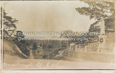 Eltham District Historical Society Inc
Postcard - Photograph postcard, Greensborough Road, Eltham, c.1925
Rare postcard showing view looking down Bridge Street with the Eltham Obelisk in situ in its original location. The Obelisk War Memorial was unveiled 3 August 1919. Subsequent to the unveiling provision was made of a stone retaining wall topped with a chain link and granite stone boundary. Along with the use of the name Obelisk Corner, the Bridge Street bridge was also known as Obelisk Bridge. The Obelisk was relocated to the fornt garden of the Eltham RSL sub-branch in the mid 1950s as a result of road widening and corner improvements. The Bridge Street Bridge was replaced with a new concrete bridge in 1956-1957.Digital file only Postcards scanned from the collection of Michael Aitken on loan to EDHS, 2 Sep. 2022michael aitken collection, eltham, postcards, bridge street, bridge street bridge, obelisk, obelisk corner, eltham cenotaph, eltham obelisk, war memorial, main road -
 Eltham District Historical Society Inc
Album - Photograph Album, Alan Gardner, Engineering Infrastructure Projects, 1939-1942
alan gardner collection -
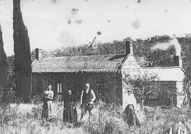 Eltham District Historical Society Inc
Photograph, Phillip Shillinglaw with his mother Jean and daughters Mary and Elizabeth in front of their home, Wattle Brae, Main Road, Eltham, c.1905
Copy of an original image. It appears that this was taken at the same time as EDHS_05725 PANEL 1875-1920 Panels began to be produced around 1875, and were particularly suited, because of their larger size, for capturing family, or even larger, groups. They measured 8.5 by 6.5 inches (22 cm x 16.5 cm). - Frost, Lenore; Dating Family Photos 1850-1920; Valiant Press Pty. Ltd., Berwick, Victoria 1991marg ball collection, eltham, 1905, main road, shillinglaw cottage, wattle brae, elizabeth (lizzie) ann shillinglaw (1879-1972), jean shillinglaw (nee blemner 1819-1906), mary ann shillinglaw (1880-1963), phillip shillinglaw (1842-1914) -
 Eltham District Historical Society Inc
Photograph - Black and White Print, Lewis Tulk, Original Training Hut, Gillwell Park, Gembrook, Vic, c.1960
Gilwell Park is a campsite and outdoor recreation area located in Gembrook, Victoria, Australia. It is primarily used by the scouting community as a training and camping facility. The site is owned and operated by Scouts Victoria, and is one of the largest and most popular campsites in the state. It covers over 95 hectares of natural bushland, and features a range of facilities including campsites, activity areas, a dining hall, and accommodation options. Gilwell Park has a long history within the scouting movement, and is named after the original Gilwell Park located in Epping Forest, England. The English site is considered the spiritual home of scouting, and was where the first Wood Badge training course was held in 1919. Today, Gilwell Park at Gembrook offers a range of training courses and programs for scouts, leaders, and other community groups. It is also a popular destination for school camps, corporate team-building events, and outdoor enthusiasts looking to explore the natural beauty of the region. [Source: ChatGPT Open AI - Gilwell Park in Australia.. (2023, March 23). Retrieved from https://chat.openai.com/chat] Donated by Lewis Tulk, former Scout Area Training Commisioner for Leaders. Lewis did his training at Gillwell Park in London.On reverse of print, stamped with film no. 6927scouts victoria, gillwell park, gembrook, scout leader training, lewis tulk collection -
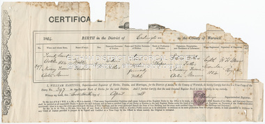 Eltham District Historical Society Inc
Certificate - Certificate of Registry of Birth, Walter Herbert Withers, 22 October, 1854
Born at Nursery Terrace, Aston Manor in the District of Erdington in the County of Warwick, England True copy of Entry 397/1854 issued 17 April 1888.1854, birth certificate, edwin withers, sarah withers (nee welsh), walter herbert withers, john withers collection -
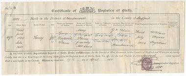 Eltham District Historical Society Inc
Certificate - Certificate of Registry of Birth, Fanny Flinn, 1 June, 1858
Born at Soho Hill in the District of Handsworth in the County of Stafford, England True copy of Entry 473/1858 issued 17 April 1888.birth certificate, 1858, fanny flinn, fanny withers (nee flinn), george frederick flinn, mary whitehead flinn (nee mcclare), john withers collection -
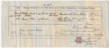 Eltham District Historical Society Inc
Certificate - Marriage Certificate, Walter Herbert Withers and Fanny Flinn, 11 October, 1887
Marriage solemnized at the Parish Church in the Parish of Handsworth, in the Couthy of Stafford Witnessed by Frederick George Flinn, Ethel Creswell, M.W. Flinn, Walter Flinn, Alice E. Flinn, Charles E. Withers1887, alice e. flinn, charles e. withers, edwin withers, ethel creswell, fanny flinn, fanny withers (nee flinn), frederick george flinn, m.w. flinn, marriage certificate, walter flinn, walter herbert withers, john withers collection