Showing 855 items matching "parish plan"
-
 Ringwood and District Historical Society
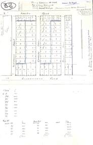
Plan, Plan of Subdivision No.11498 with handwritten costing notations - East Ringwood Central Estate c.1948
Two handwritten pages showing layout of Subdivision no 11498 with surveyor notations including property sizes and road construction cost calculations. Drainage easement 6 feet wide shaded blue.Plan of Subdivision No. 11498, Part of Crown Allotment 27, Parish of Ringwood, County of Mornington, (Certificate of Title Vol 5120 Fol 1023945). Owner Mr Vogel. Subdivision includes Knaith Road, Northwood Street, Langley Street, Bondi Street, and Government Road (later Alexandra Road), Ringwood East. G. Parsons & Sons, Licensed Surveyors, 389 Flinders Lane (Melbourne). -
 Ringwood and District Historical Society
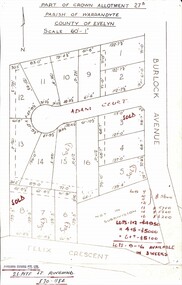
Map, Subdivision Plan - Adam Court area, North Ringwood, Vic. - circa 1960s
Single page plan printed showing allotments included in un-named subdivision layout surrounding Adam Court, Ringwood North. Subdivision includes Adam Court, Burlock Avenue, and Felix Crescent. Sold allotmenets marked in red, with price notations.Page heading - Part of Crown Allotment 27B Parish of Warrandyte County of Evelyn Scale 60'-1". Rubber stamp imprint and handwritten address at bottom of page - "Binburra Estates Pty. Ltd. 23 Pitt St., Ringwood, 870-1184". -
 Ringwood and District Historical Society
Document, Sale of Land Act documents - Part of Crown Allotments 14A, 40A, 40B & 4C, Parish of Ringwood - 1895
Certificate of Title - Georgina Elizabeth Wingfield Knox, wife of William Robert Knox, part of allotments 14A and 40A, 27th November, 1895, and subsequent transfers up to 1959. Plan of Subdivision includes Allens Road, The Greenway, Dickasons Road, and Canterbury Road, Ringwood. (With further residential and commercial developments taking place since the 1920s, this area became part of the suburb of Heathmont.) -
 Ringwood and District Historical Society
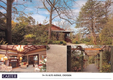
Document, Real Estate History of "Shadowood", 74-76 Alto Avenue, Croydon, Victoria
Folder of Estate Agent's notes compiled in preparation for property auction, 11th October, 2008. Two-page history of "Shadowood", display photo of house with floor plan dating from circa 1920s, copies of LANDATA title documents. Map of Wicklow Hills subdivision, including Alto Avenue, Elesmere Avenue, Glenora Avenue, Wicklow Avenue, and railway line to Lilydale. Title Vol 1323 Fol 264412 Allotment 43C Parish of Warrandyte - Ann McKean, dated 6th October, 1881. Title Vol 1937 Fol 387367 Part of Allotment 43C Parish of Warrandyte - Richard Bonynge Kelly, 11th August, 1887. Title Vol 2728 Fol 543569 Part of Allotment 43C Parish of Warrandyte - Thomas Robertson, 27th July, 1898. Title Vol 4161 Fol 832181 Part of Allotment 43C Parish of Warrandyte - John Gordon Robertson, 4th November, 1918. Title Vol 4490 Fol 897808 Lots 82 and 83, Plan of Subdivision 7478 - Elizabeth Rutherford Morell, 12th August, 1921. Title Vol 4617 Fol 923322 Lot 82, Plan of Subdivision 7478 - Flora Clapperton, 23rd September, 1922. Title Vol 8409 Fol 533, part of Lot 82, Plan of Subdivision 7478 - Hugh Ravenscroft Hastings Wettenhall and Sybella Anne Wettenhall, 1st May, 1962. -
 Ringwood and District Historical Society
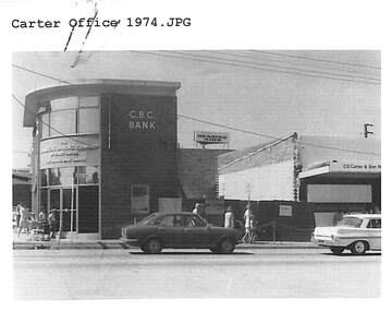
Document, Certificate of Title and miscellaneous property records - Carter Real Estate, 122 and 124-128 Maroondah Highway, Ringwood, Victoria
Transfer of Land Act Title dated 24/4/2002 - Volume 10314 Folio 972 Crown Allotments 11H and 11J, Parish of Ringwood, Entitlement Grant to a depth of fifteen metres - 29/1/1997, City of Ringwood planning permit and diagram of office floor plan - 1973. -
 Ringwood and District Historical Society
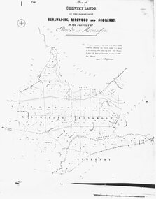
Photograph, Map-Country Lands, in the parishes of Nunawading, Ringwood and Scoresby (undated)
Early (undated) photograph of plan of "Country Lands, in the parishes of Nunawading, Ringwood and Scoresby, in the counties of Bourke and Mornington". -
 Glen Eira Historical Society
Document - SHELFORD GIRLS’ SCHOOL AND KINDERGARTEN
This file contains 2 items relating to plans for the buildings and grounds of the school: 1/2 copies (1photocopy, 1 original) of the July 1982 ‘Shelford Planning Brief: Church of England Girls’ Grammar School’, written by the Caulfield City Council. The brief describes the history of the school, its current grounds and plans for future expansion. It also contains 2 ground plans: one of the existing school site and 1 of the planned future school site. 2/1 copy of a City of Caulfield Council memo regarding the July 1982 Shelford Planning Brief, describing small changes to the brief. Written by J. Floyd, 24/11/1982.city of caulfield, shelford c.e.g.g.s., caulfield, glen eira road, st mary’s anglican church, seymour road, allison road, ‘helenslea’, hood justice mr, hood crescent, st mary’s parish hall, helenslea road, education, gymnasiums, schools, students, secondary schools, primary schools, bentleigh, classrooms, car parks, libraries, traffic, playgrounds, teachers, windows, plans, shelford planning brief, kilvington planning brief, shelford church of england girls’ grammar school, floyd j, fences, kilvington baptist girls’ -
Glen Eira Historical Society
Document - LAND SUBDIVISIONS 1880-1938
... , but appears to be circa1900 7/‘Riddell Estate – Plan of Subdivision..., but appears to be circa1900 7/‘Riddell Estate – Plan of Subdivision ...This file contains various subdivisions’ advertising flyers and cards. 1/Advertising announcement for auction sale of land (15 lots) at Glenhuntly Tram Terminus, to be held on 29/03/1924. Verso is map of the area (21.5cm x 29cm) 2/Advertising announcement for Trustees’ Auction sale of corner shop sites at Caulfield South near Glenhuntly Road and Hawthorn Roads, 15/11/1927 (21cm x 31cm) 3/Advertising pamphlet (A3) for auction of Cantala Estate, East St. Kilda (32 allotments), between Dandenong, Waiora, and Alma Roads, 21/05/1938 (15.5cm x 28.5cm) 4/Seven advertising postcards relating to auctions of land in Caulfield and Elsternwick. Only one (10 December 1881) with a year on it. (Each 13.5cm x 9cm) 5/Four more advertising postcards relating to auctions of land in Caulfield. One is dated 31/11/1880(?); another 09/02/1905. A third has no date. A fourth postcard is a map of allotments between Orrong, Kooyong, Seymour and Alison Roads, Caulfield, no date (each 13.5cm x 9cm) 6/Large advertising poster (41cm x 52.5cm) for ‘Carnegie Land Sale’ auction of the Egan Estate (near Carnegie Railway Station) on 12 April, no year given, but appears to be circa1900 7/‘Riddell Estate – Plan of Subdivision – Parish of Prahran’ mounted map, no date, probably c. 1900 (16cm x 21cm)auctions, house auctions, land subdivision, land development, subdivisions, caulfield, land subdivisions, east st. kilda, glenhuntly, carnegie, map, ‘new glenhuntly tram terminus estate’, ‘cantala estate’, ‘strathnaver estate’, ‘range estate’, ‘egan estate’, ‘riddell estate’ -
 Glen Eira Historical Society
Article - REGENT LODGE, REGENT STREET, 46, ELSTERNWICK
This file contains 10 items about the Regent Lodge Extension Appeal: 1/Three promotional pamphlets, all called ‘Regent Lodge: A special kind of care’, stating that a building appeal will be launched early next year. The pamphlets also list office bearers. 2/A letter from Rodney Horsfield, Chairperson of the Project Working group, to Betty Freeland of the Elsternwick-Caulfield South Parish, dated 25/03/1992, asking for her to consider becoming a member of the Appeal Team. The letter also contains information on the history of Regent Lodge, the plans for development and progress on raising funds to date. 3/A letter from Ian Clark, Chairman of the Regent Lodge Extension Appeal, to Betty Freeland, dated 18/05/1992, inviting her to the official launch of the Regent Lodge Extension Appeal at Caulfield Grammar School, 217 Glen Eira Road Caulfield on 31/05/1992. The letter gives brief details on the launch, saying it will be attended by the appeal’s patron, the Honourable Joan Child, AO, and the Playback Theatre company. 4/A letter, recipient and sender unknown, dated 26/05/1992, giving details of the appeal launch and a brief history of Regent Lodge. 5/Two newspaper articles from the Southern Cross, Caulfield, dated 16/06/1992. The first, ‘Grant boost for dementia sufferers’, discusses a federal government grant of $8 million to dementia services, and $9 million to disability services. Heathlands, Camden Court, Lovell House, Clarence Court, Regent Lodge and St. Kilda House all received funds. The second, ‘Lodge building appeal launched’, describes the Regent Lodge Extension Appeal and its launch, and includes brief comment by appeal patron Joan Child. The article describes the plans for the appeal and extension, and outlines how readers can make donations. Included is a black-and-white photograph of Joan Child with members of the Playback Theatre Group at the Appeal Launch. 6/The original of the photograph used in the newspaper article in item 5, showing Joan Child with members of the Playback Theatre Group at the launch of the Regent Lodge Extension Appeal. 7/A letter from Rod Horsfield, Convenor of the Project Working Group, to Betty Freeland, dated 22/06/1992, discussing the launch and asking for the opportunity to meet with her Parish council or Finance Committee. 8/The plans for the extension of Regent Lodge, as well as a colour drawing of what the front of the extension will look like. 9/Preliminary photographs taken for the appeal brochure ‘Regent Lodge: Committed to Caring’. Twelve black-and-white photographs of two elderly residents at tea. Also, one black-and-white photographs of an elderly resident being assisted by another person, likely a staff member. 10/Three copies of the appeal brochure ‘Regent Lodge: Committed to Caring’. The brochure contains information about the lodge, the plans for the development, including a floorplan for a typical six bedroom unit, the costs of the extension and breakdown of how the appeal target amount would be spent, and messages from patron Joan Child, Appeal Committee Chairman Ian Clark, and Convenor of the Project Working Group Reverend Rod Horsfield. Also included is a list of the members of the Appeal Committee and Project Working Group. Black-and-white photographs of residents and workers at the Lodge are included in the brochure.regent lodge, regent street, elsternwick, emma street, caulfield south, heathlands, camden court, lovell house, st. kilda house, balaclava, caulfield grammar school, glen eira road, st. georges road, caulfield, uniting church, uniting church lodge program, regent lodge alzeimer appeal, regent lodge extension appeal, tansley hunt and partners, nepean presbytery, child joan the honourable, horsefield rod rev., horsfield rod rev., horsfield rodney rev., lukies noela mrs., campbell jack, cardell bob, davies gail mrs., greensmith duncan, tansley vern, merrick ruth ms., seccull barbara ms., freeland betty miss, clark ian, wilcox rosemary mrs., coleman julie, playback theatre company, martens veronica mayor, brown george, terrell tom, diseases, disabled people, nursing homes, fundraising events, aged people -
 Federation University Historical Collection
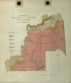
Plan - Map, Mines Department, Parish of Narmbool and part of Cargerie, County of Grant, 1892, 06/1992
This map shows the position of the homestead on the Narmbool Pre-emptive Right, volcanic craters, stock reserve, quarry and geological eras,Geological map showing Narmbool and part of Cargerie in the County of Grant in five colours, predominantly pink.narmbool, cargerie, narmbool pre-emptive right, williamson's creek, leigh river, green hill, collyer's hill, volcano, crater, krause, ferdinand krause -
 Federation University Historical Collection
Plan, Plan of Survey Crown Allotment 9A and Part of Crown Allotment 8 Section 10 City and Parish of Ballaarat, after 1929
... ballaraat ballarat plan plan of survey armstrong street skipton ...ink and watercolor on watermarked laid paper dated 1928text and measurementsballaraat, ballarat, plan, plan of survey, armstrong street, skipton street -
 Federation University Historical Collection
Plan, Scarsdale County of Grenville, 1889, 26/01/1889
Rectangular plan of a geological survey edged in masking tape. It is predominantly grey, pink and green, but has some yellow. scale is 40 chains to one inch. (see Cat. No. 1098 for report on the Parish of Scarsdale)scarsdale, grenville, krause, browns and scarsdale, mopianimum, watershed, yarrowee, woady yalloak, timber reserve, department of mines, plans, cgt, crown lands, ferdinand krause -
 Federation University Historical Collection
Plan, Ballaarat City Parish Plans, 1931, 09/03/1931
... Street, Hickman Street Ballaarat City Parish Plans, 1931 Plan ...Large Scale plans showing streets, allotments, dimensions, crown grantees, dates granted, etc Sheet 2: Sturt Street, Rubicon Street, Pryor Street, Humffray Street, Sebastopol Street, Armstrong Street South, Fraser Street, Hickman Street ballarat, ballaarat, plans, city of ballarat -
 Federation University Historical Collection
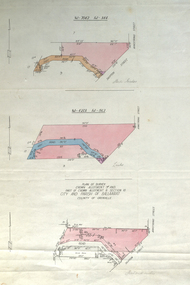
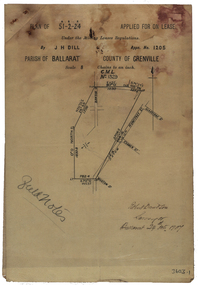
Plan, Parish Of Ballarat Mining Lease applied for by J.H. Dill, 1907, 24/10/1907
Removed from Catalogue No 3601.Lease, plan and field notes showing the survey for the New Kohinoor Comapny Lease No 1205. Scale: 8 chains to 1 inch (1:6336)new kohinoor, survey, robert davidson, j.h. dill, dill, mining, ballarat, new koh-i-nor -
 Federation University Historical Collection
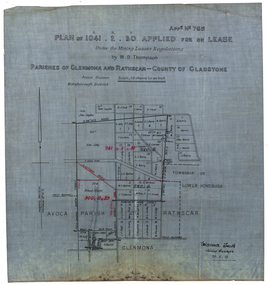
Plan, Plan applied for a Lease, Parishes of Glenmora and Rothcar, 27/05/1913
Plan on linen showing mining leases around the township of Lower Homebush, District of Maryborough. Scale: 20 chains to in inch (1:15840) WGS 84 Centroid Lat: 37 degrees 01 feet 35 inches S Long: 143 degrees 30 feet 35 inches S NS: 3.2km EW: 2.8km glenmona, rathcar, gladstone, maryborough, mining, clarence smith, homebush, clarence smith, w d thompson, peter leyden, b elliot, c horne, a field, john leydon, g jolly, r e jolly, d garner, s j barry, m harris, a harris, w j mcconnell, ellen harris, r j harris, j barry, t curtain, s garner, e barry, m j barry, l e squires, wilkins jnr, e c grace, e j field, mary field, m broughton, b l lusby, m j lusby, j e field, f broughton, j gillock, m simmons, glenmona, rathscar, parish of avoca, maryborough district, albert field, g grose, j harris -
 Federation University Historical Collection
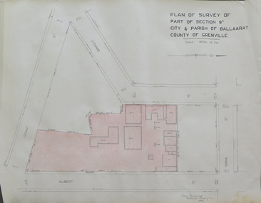
Plan, Plan of Survey of Part of Section 9A City & Parish of Ballarat County of Grenville (Albert Street frontage), 1932
The M.B. John Trade Building was built on the Albert Street Frontage..1) Plan of SMB showing Albert, Grant, Lydiard and Dana streets, on paper with colored highlights undertaken by Ballarat School of Mines student George Murrowood in 1932 .2) Hand written page by George Murrowood, of technical description of land surveying Grade II 1932ballarat school of mines, surveying, george murrowood, albert street, alumni, m.b. john building, architectural plan -
 Federation University Historical Collection
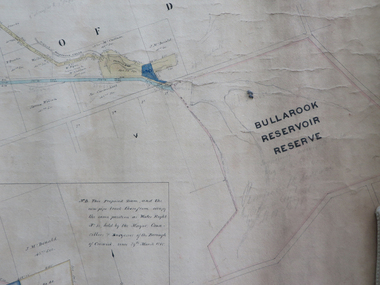
Plan, Creswick Water Supply from Bullarook to Creswick, 02/10/1869
Probably gazetted on 12 April 1872 (pg 737)Large horizontal paper plan glued in three sections to a linen backing. Coloured plan shows pipe and rack track from the Bullarook Reservoir to Albert Street, Creswick. Attached with ribbon top left are twelve pages giving bearing and lengths / descriptions of pipe and rack track. Five information boxes drawn along the bottom of plan gives extra information where pipe passes through private properties. Main heading 'Plan of Creswick Water Supply / scale eight chains to an inch / County of Talbot / Parish of Creswick'. Calculations and hand written notes in ink and pencil also on plan. Verso 'Dean Reservoir'. Signed and dated.creswick, water supply, bullurook reservoir, dean, bush inn, hesken, rivers, warner, taylor, gillard, mccormack, mcdonald, brown, naples, humbug hill sluicing co, frank rivers, w.r. taylor, j. and m. mccormack, j. mcdonald, richard brown, c. naples -
 Federation University Historical Collection
Plan, Parish of Dowling Forest, County of Ripon and Grenville, 19
Scale [1:31 680]. 40 chains to 1 in.Geological map on a cadastral base, showing the occurence of reefs, and alluvial deposits. Relief shown by contours.dowling forest, wyndholm, wyndholm pre-emptive right, miners rest, ballarat racecourse, winter's swamp, police reserve, miner's rest, winters swamp, geology -
 Federation University Historical Collection
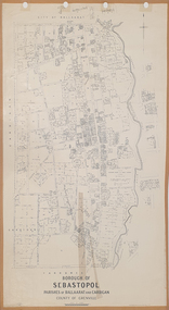
Plan, Borough of Sebastopol, 1940, 01/07/1940
Sebastopol became a suburb of the City of Ballarat.Plan showing the streets, allotments creeks in the Borough of Sebastopol, Parishes of Ballaarat and Cardigan, County of Grenville, in 1940. sebastopol, t. rider, yarrowee creek, leigh river, st george's reserve, leigh creek, sebastopol public gardens, sebastopol recreation reserve, gravel reserve, night soil depot, sanitary depot, rubbish depot -
 Federation University Historical Collection
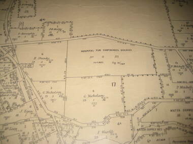
Plan - Plan - Cadastral, Parish of Ballaarat - Sheet 3 (only), 03/03/1932
Sheet 3 of the Parish of Ballart showing Government roads, crown allotments, dimensions, crown grantees, date of grants, etc,ballarat, plan, hospital for contagious diseases, sebastopol, sebastopol rifle range, fiscalini, leigh river, yarrowee creek -
Federation University Historical Collection
Plan, Nick O'Time Lead, Parish of Tarnagulla
... Lead Nick O'Time Lead, Parish of Tarnagulla Plan ...A3 Photocopy of the Nick'O'Time Leadplan, mining, cgt, tarnagulla, nick o'time -
 Federation University Historical Collection
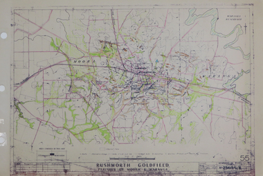
Plan, Rushworth Goldfield: Parishes of Moora and Waranga, pre 1954
Printed plan on paper with hand colouringrushworth, moora, waranga -
 Federation University Historical Collection
Plan, Parish of Lal-Lal County of Grant
Printed colour map on paperlal lal, mt doran, lal lal racecourse, geology, geological, moorabool river, mount duran -
 Federation University Historical Collection
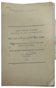
Report, E.C. Whittell, Deep Lead at Black Range, Near Albury, 1901, 1895
Foolscap report on boring operations, plans and sections by E.C. WhittellFront cover "With DC MCLachlan's complimentsdepartment of minse and agriculture, e.c. whittla, black range, albury, parish of albury -
 Federation University Historical Collection
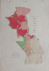
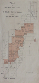
Plan, Land held under leases for Gold Mining between Bet Bet and Timor, not dated
Printed plan with red shading, of gold mining leases between the Parishes of Dunolly and Maryborough.plan, mining leases, gold mining, dunolly, maryborough, bet bet, timor, mining -
 Federation University Historical Collection
Plan, Plan of Part of Section 9A City and Parish of Ballarat, 1933
... plan with colouring Plan of Part of Section 9A City and Parish ...Hand drawn ink plan with colouringsmb buildings, ballarat school of mines, buildings, model mine, mining laboratory, grant street, lydiard street south, dana street, albert street, old chemistry building, architectural plans -
 Ringwood and District Historical Society
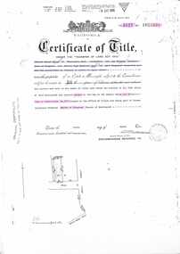
Document - Transfer of Land Act, Certificate of Title Vol 5127 Fol 1025238 including Ringwood Masonic Hall
Photocopied Certificate of Title Vol 5127 Fol 1025238 dated 9th March, 1926. Ernest Albert Milne (orchardist) and Jay Wilkins (builder) of Ringwood and Ernest Hugh Emmanuel Hann (carpenter) of East Ringwood are now proprietors as tenants in common in equal shares, Lot 30 on Plan of Subdivision No. 5577, part of Crown Allotment 19, Parish of Ringwood. Location map includes Aird Street, Pratt Street, Whitehorse Road. Subsequent Proprietors Transfers & Mortgate details include: Herman Pump and Frank Kenworthy of Ringwood and Albert Raymond of Collins Street Melbourne, trustees for the time being of the Loyal Ringwood Lodge No. 6724 of the MUIOOF Victoria Friendly Society - 26 June 1936, Holeproof Limited of 204 Sydney Road Brunswick, proprietor by transfer on 18th February, 1947, (*) Ringwood Masonic Hall Company Limited of 173 Whitehorse Road Ringwood, proprietor by transfer on 14th June, 1950, City Mutual Life Assurance Society Limited registered 1st March, 1965, ANZ Banking Group Limited, registered 10 June, 1981 & Discharged 3 June, 1982, Mayor Councillors and Citizens of the City of Ringwood registered as proprietors 6th July, 1982. (*During WWII, Holeproof had been renting the hall where they manufactured socks.) -
 Ringwood and District Historical Society
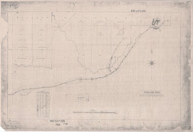
Map, Road Plan 108 - Gipps-land Road, Parishes of Bulleen and Warrandyte (Ringwood, Victoria) - 1855
Surveyor's map of the part of the main road from Melbourne to Gippsland following "Barker's Track" south of Mullum Mullum or Deep Creek. Map references include Roman numerals marking distances measured in Links between trees at turns in the road.Submitted to the Surveyor General (Signed) July 2nd 1855. -
 Ringwood and District Historical Society
Map, Plan of Country Lands in the Parishes of Nunawading Ringwood and Scoresby - circa 1855
Blueprint copy of Survey Map detailing original Selectors' names and property locations. List of Parish map references including property bearings, distances in Links, and markings on trees. Descriptive remarks include areas marked "Farmer's Common", "Poor soil thickly/moderately timbered with stringy bark", and location of water and firewood reserves."Surveyed and plotted by N.M. Bickford, Superintendant of Mr. Hodgkinson's Field Party". "The land comprised in this survey is of inferior quality, moderately undulating, and thickly wooded. It is watered by Dandenong Creek and Deep Creek." Inset map showing location of (*proposed) cemetery on southern corner of Lillydale Road from Melbourne and Sawmill Road, later Mount Dandenong Road. (*Cemetery did not eventuate.) -
 Ringwood and District Historical Society
Map, Plan of the Parish of Warrandyte County of Evelyn - 1841
... Plan of the Parish of Warrandyte County of Evelyn - 1841...) and Mullum Mullum Creek (Ringwood). List of Parish map references ...Blueprint copy of Survey Map W27 detailing original Selectors' names and property locations between Yarra Yarra River (Warrandyte) and Mullum Mullum Creek (Ringwood). List of Parish map references including property bearings, distances in Links, and markings on trees. Pound Bend area of Warrandyte marked as Reserve For Aborigines. Descriptive remarks include areas marked "scrubby, flat, sandy soil". Several other references faded and illegible.(Map) by T.H. Nutt Feb 3 1841.