Showing 761 items
matching planning paper
-
 Linton and District Historical Society Inc
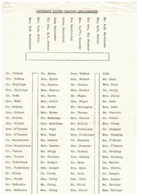
Plan, Centenary Dinner Seating Arrangements, 1964
Foolscap sheet of paper with typed names of people and where they will be seated for a centenary dinner. Guests who attended include Sir and Lady Delacombe, the Premier of Victoria at that time Sir Henry Bolte and his wife.shire of grenville centenary, sir rohan delacombe, lady delacombe, henry bolte, mrs. h. e. bolte -
![Map, Plan of Subdivision of Crown Portion 23 & parts 24-25, Parish of Korkuperrimul [1900s?]](/media/collectors/5e461d8021ea67224c82f2a1/items/675fe058304668462205d4fb/item-media/675fe0ef304668462205d7d6/item-fit-380x285.jpg) Bacchus Marsh & District Historical Society
Bacchus Marsh & District Historical SocietyMap, Plan of Subdivision of Crown Portion 23 & parts 24-25, Parish of Korkuperrimul [1900s?]
The Parish of Korkuperrimul includes a significant section of the township of Bacchus Marsh and extends in western and northern directions from the township area. The date of the subdivision indicated on this plan has not been established. The engineer's stamp on the drawing shows the firm of Muntz and Muntz who were operating under that name in the early part of the 20th century.A single page paper map showing 20 blocks of land for sale in the Parish of Korkuperrimul. Scale 100 feet to 1 inch. The map is pasted into a bound volume containing 76 maps or plans in total. High resolution digital image stored on BMDHS computer network. Stamped: 'Muntz & Muntz Civil Engineers, Architects & Surveyors, Trustees Chambers ?? Cor Collins Street and Bank Placeland sales bacchus marsh, bacchus marsh victoria maps, land sales korkuperrimul parish -
 Bacchus Marsh & District Historical Society
Map, Parish of Yangardook, County of Bourke 1876
... A single page paper map showing the plan for the Parish.... Noone, 1.8.76 A single page paper map showing the plan ...The parish of Yangardook lies directly north of the township of Melton. The locality of Toolern Vale lies in the centre of this parish. A single page paper map showing the plan for the Parish of Yangardook in the in the County of Bourke. Scale 40 chains to 1 inch. The map is pasted into a bound volume containing 76 maps or plans in total. High resolution digital image stored on BMDHS computer network. Photo lithographed at the Department of Lands and Survey, Melbourne by J. Noone, 1.8.76yangardook parish maps, toolern vale victoria maps -
 Bacchus Marsh & District Historical Society
Map, Gaynor Street Area Land Sales, Maddingley, 1888
This map was produced for a major sale of land in the Maddingley area of Bacchus Marsh in 1888. The sale was conducted by two firms from Melbourne, Carney and Kelly 12 Swanston Street Melbourne. and 'Richardson, Kerr & Co. 40 Flinders Lane Melbourne. 136 blocks were for sale.A single page paper map showing land allotments for sale in the Maddingley area of Bacchus Marsh. Locations shown include Gaynor Street, Maddingley Road South, Parwan Road, Mitchem Street, Typpynge Street, Finn Street and East Maddingley Road. . The map is pasted into a bound volume containing 76 maps or plans in total. High resolution digital image stored on BMDHS computer network. bacchus marsh victoria maps, maddingley victoria maps, land use, maddingley victoria history, land sales bacchus marsh, land sales maddingley -
 Bacchus Marsh & District Historical Society
Map, Gaynor Street Land Sales, Maddingley, circa 1880s-1890s
This map was produced for a major sale of land in the Maddingley area of Bacchus Marsh. The precise date of the sale has not been determined. Features present on the map such as the Bacchus Marsh Railway Station indicate the land sale must have taken place some time after 1887 when the Railway Station opened. A single page paper map showing land allotments for sale in the Maddingley area of Bacchus Marsh. Locations shown include Gaynor Street, Maddingley Road South, Parwan Road, Mitchem Street, Typpynge Street, Finn Street and East Maddingley Road. . The map is pasted into a bound volume containing 76 maps or plans in total. High resolution digital image stored on BMDHS computer network. bacchus marsh victoria maps, maddingley victoria maps, land use, maddingley victoria history, land sales bacchus marsh, land sales maddingley -
 Federation University Historical Collection
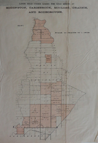
Plan, Lands held under leases for gold mining at Biddington, Carisbrook, Moolort, Craigie and Rodborough, not dated
Printed paper map with red shadingbiddington, carisbrook, moolort, craigie, rodborough, mining lease, d. fitzpatrick, m. mullins, d. fern, kong meng, p. mitchell, curtain and co, a. robertson, j. fay, chalk's extended, tullaroop creek, mining, gold mines, bucknall's estate, chalk's estate -
 Whitehorse Historical Society Inc.
Newsletter - Blackburn and District Tree Preservation Society Inc, Blackburn and District Tree Preservation Society Inc, Blackburn and District Tree Preservation Society Inc Newsletter, 2020
Newsletter No.255 of the Blackburn and District Tree Preservation Society Inc. Sep 2020.Paper and print, 12 ppnon-fictionNewsletter No.255 of the Blackburn and District Tree Preservation Society Inc. Sep 2020.blackburn and district tree preservation society, payne anne, environmental issues, civic planning -
 Mont De Lancey
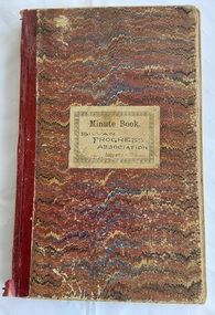
Book, Norman Bros, Silvan Progress Association Minute Book, Unknown
This blank book was used by the Silvan Progress Association. Minutes of the first meeting were taken Sat March 1th 1916 and the last minutes were held in the Library Mechanics Hall on 5th Oct. 1922. The book is filled with Minutes of the monthly meetings and has three paper insertions - a Mont De Lancey Wine List with three wines and their prices per bottle. A second quite damaged paper is: Wandin ? Progress Association Inaugurated 26th Oct 1912. The meeting was held Jan 11, 1913. It lists the monthly meetings and minutes taken up to March 28 1913. The third document is a copy of 13 typed pages from the Shire of Lillydale to Mr. S. Bradley, Hon. Secretary, Silvan Hall Committee, Silvan suggesting to the Committee that the attached plan for the maintenance and betterment for the hall be forwarded to the Public Health Department for approval. It includes a list of names of Guarantors and witnesses.A large red, blue and cream wavy lined paper patterned covered Norman Bros., Minute Book with burgundy tape on the spine. This blank book was used by the Silvan Progress Association. Minutes of the first meeting were taken Sat March 1th 1916 and the last minutes were held in the Library Mechanics Hall on 5th Oct. 1922. The book is filled with Minutes of the monthly meetings and has threeo paper insertions - a Mont De Lancey Wine List with three wines and their prices per bottle. A second quite damaged paper is: Wandin ? Progress Association Inaugurated 26th Oct 1912. The meeting was held Jan 11, 1913. It lists the monthly meetings and minutes taken up to March 28 1913. The third document, dated 17th May 1928, is a copy of 13 typed pages from the Shire of Lilydale to The Hon. Secretary, Silvan Hall Committee, Silvan. It includes a list of names of Guarantors and witnesses.non-fictionThis blank book was used by the Silvan Progress Association. Minutes of the first meeting were taken Sat March 1th 1916 and the last minutes were held in the Library Mechanics Hall on 5th Oct. 1922. The book is filled with Minutes of the monthly meetings and has three paper insertions - a Mont De Lancey Wine List with three wines and their prices per bottle. A second quite damaged paper is: Wandin ? Progress Association Inaugurated 26th Oct 1912. The meeting was held Jan 11, 1913. It lists the monthly meetings and minutes taken up to March 28 1913. The third document is a copy of 13 typed pages from the Shire of Lillydale to Mr. S. Bradley, Hon. Secretary, Silvan Hall Committee, Silvan suggesting to the Committee that the attached plan for the maintenance and betterment for the hall be forwarded to the Public Health Department for approval. It includes a list of names of Guarantors and witnesses.meetings, reports, proceedings, minutes of meetings -
 Friends of Ballarat Botanical Gardens History Group
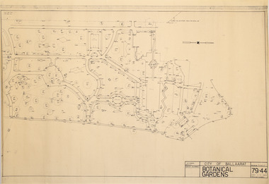
Plan - Survey Plan A, G. Creek, City of Ballarat Botanical Gardens
HistoricSurvey map on papersurvey map, city of ballaarat, ballarat botanical gardens -
 Friends of Ballarat Botanical Gardens History Group
Plan - Survey Plan A, G. Creek, City of Ballarat Botanical Gardens
HistoricSurvey map on papersurvey map, city of ballaarat, ballarat botanical gardens -
 Glenelg Shire Council Cultural Collection
Work on paper - Drawing No. 2, Plan Shewing Works Recommended by Sir John Coode, 1879
Drawing of Portland Bay showing the proposed harbour. Portland town centre is shown as it Portland Botanic Gardens and Battery Hill.Top left: Victorian Harbours / Portland / Plan Shewing Works Recommended by / Sir John Coode / in his report dated Dec r 1879 / The proposed works shown by red colour / the extensions to be undertaken in the first instance across by red colour / subsequent extensions and reclamations are coloured brown Top Right: Drawing No. 2 Portland Borough Council stamped top leftportland harbour, sir john coode, portland, plans, drawings, 1800s -
 Bendigo Historical Society Inc.
Booklet - 1916 - 1998 Booklet of Bendigo East State School and 1995 School Profile
The black and white A4 sheet of paper is titled P.S 3893 Bendigo East School Profile. It highlights the school guiding principles, curriculum, resources and facilities, as well as future plans. The introduction gives a brief history of the school's early days. The green 8-page booklet titled Bendigo East Primary School N0. 3893 1916-1998 has a grainy photograph of the school on the front cover. Inside the cover is a brief history of the school from 1916 to 1998. The brochure mentions the school closure and amalgamation with White Hills Secondary College. There are four photographs in the brochure and a list of headmasters/principals.bendigo east state school, bendigo schools, gemma starr collection -
 Warrnambool and District Historical Society Inc.
Document (item) - Allansford land purchase document, Land purchase document, 1864
This paper contains details of the purchase of Lot 11 in the Township of Allansford in 1864. The purchaser, Isabella McQueen, was born in Scotland in 1814, married Alexander McQueen in 1850 and with her family migrated to Australia in 1854. After her husband's death in 1860 Isabella purchased the land in Frank Street, Allansford in 1864 and lived in a house there with family members until her death in 1895. She had purchased the land, via an agent, from John Allan who with his brothers were the pioneer European settlers in the Allansford area. John Allan had created the township of Allansford in the mid 1850s by sub-dividing the land he owned there. John Allan moved to the Gippsland area late in 1864. This piece of paper is most significant as it is an original record of an early transaction in the history of Allansford, a town now part of Warrnambool City.Mrs isabella McQueen Bot. of Robert Gregory As agent for J M Allan Esq. Lot no. 11 as marked and described on the Plan of Subdivision of the Township of Allansford. For which I have received the um of five pounds Stg. being the purchase money of same. Robert Gregory 21st October 1864allansford history, john allan, isabella mcqueen -
 Bacchus Marsh & District Historical Society
Building plans and designs for various hotels in the Bacchus Marsh region c.1930s-2000s
Plans in this collection include hotels and premises licensed to sell liquor in Ballan, Lal Lal, Myrniong, Spargo Creek and Wallace.Architecture plans and drawings on single sheets of paper mostly ranging in size from A3 to A2. BMDHS Location: AR/R5/S2hotels bacchus marsh region, hotels designs and plans, hotels architectural plans, hotels building plans -
 Glen Eira Historical Society
Photograph - Elsternwick Club, Sandham Street, 19, Elsternwick
Four items about the Elsternwick Club: 1/ An undated black and white photograph (90mm x 140mm) of the exterior of the Elsternwick Club Building at Sandham Street. 2/ Two identical postcards advertising the opening of the Tabaret at the Elsternwick Club in 1996, with four historic photographs of the club included on the front. The back advertises the opening hours, price of alcohol and gaming machines. 3/ An original colour site plan (300mm x 290mm) on tracing paper in ink of the Club’s premises, prepared by Thomas Watts and Son Architects 77 Swanston Street with a colour photocopy of this same plan. 4/ Photocopy of page 15 from the 1985 second edition of the City of Caulfield's "caulfield's building heritage" directory and information guide which provides basic information about the Elsternwick Club building and includes an illustration (115mm x 85mm) of the exterior of the Club.For item 1 inscription: Elsternwick Club Sandham Stst georges road, elsternwick, elsternwick club, thomas watts and son, sandham street, site plans -
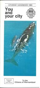 Warrnambool and District Historical Society Inc.
Booklet - City of Warrnambool Citizens' Handbook 1983
This Citizens' Handbook was posted to all citizens of Warrnambool in 1983. It contains an introductory message from the Mayor of the time, Cr. Ron Anderson and information relating to council run facilities and services. There is a page explaining the Warrnambool Bike plan and a section on how to save water. The blue centre pages explains property valuations and how to pay council rates. The rear page lists the contact details for councillors from each of the four municipal wards (Albert, Hopkins, Merri, Victoria) This booklet is an example of information provided to all City of Warrnambool citizen's in 1983. It gives an overview of council run facilities and services in 1983 and will be useful for researchers.A 20 page stapled booklet. Sixteen pages are printed on glossy white paper with black print. The centre pages are blue with black printing. The front cover has a black and white City of Warrnambool crest in the top right and a colour photograph of a Southern Right whale and calf swimming in the sea. The bottom left hand corner of the front cover has a postage paid rectangle printed in black print. The left hand side of the back cover has four ward maps printed in yellow and red. The ward names are printed in blue and the Councillor's details are in smaller brank print.Front Cover: Citizens' Handbook 1983 You and your city; Postage Paid Australia; To the Citizens of Warrnambool Back Cover: Your Ward Councillors Albert Hopkins Merri Victoriawarrnambool city council, citizens' handbook, warrnambool performing arts centre, warrnambool bike plan, albert ward, hopkins ward, merri ward, victoria ward -
 Bacchus Marsh & District Historical Society
Map, Gorrockburkchap Parish Map, County of Grant c.1915
The parish of Gorrockburkchap (sometimes spelled Gorrockburkghap) lies to the west and south west of the township of Bacchus Marsh. The locality of Rowsley is situated within this parish area.A single page paper map showing the parish plan for Gorrockburkchap in the County of Grant. The map is pasted into a bound volume containing 76 maps or plans in total. High resolution digital image stored on BMDHS computer network. gorrockburkchap parish maps, rowsley victoria maps -
 Bacchus Marsh & District Historical Society
Map, Gorrockburkchap Parish Map, County of Grant
The parish of Gorrockburkchap (sometimes spelled Gorrockburkghap) lies to the west and south west of the township of Bacchus Marsh. The locality of Rowsley is situated within this parish area.A single page paper map showing the parish plan for Gorrockburkchap in the County of Grant. The map is pasted into a bound volume containing 76 maps or plans in total. High resolution digital image stored on BMDHS computer network. gorrockburkchap parish maps, rowsley victoria maps -
Wangaratta RSL Sub Branch
Newspaper, The Sydney Morning Herald
Newspaper announcing Japan Capitulates and plans for surrender following cease fire in the Pacific .Newspaper consisting of 16 pages of large cream paper folded in half with black printing and imagesThe Sydney Morning Herald dated Thursday August 16 1945ww2, japanese surrender, pacific -
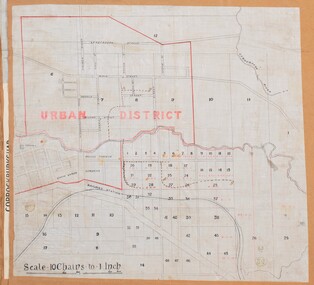 Bacchus Marsh & District Historical Society
Map, Bacchus Marsh Urban District
The date of this map has not been established but the date would be sometime after 1887 as the Bacchus Marsh Railway Station, which opened in 1887, is shown on the map. A single page paper map showing blocks of land in the urban district of Bacchus Marsh. The 'urban district' is indicated by red drawn lines on the map and includes streets and blocks on the northern side of the Werribee River in Bacchus Marsh, and streets and blocks south of the Werribee in Maddingley. Scale 10 chains to 1 inch. The map is pasted into a bound volume containing 76 maps or plans in total. High resolution digital image stored on BMDHS computer network. bacchus marsh victoria maps, maddingley victoria maps -
MYLI My Community Library
Map - Nar Nar Goon County of Mornington Map, 1944, H.E Daw - Government Printer, June 1944
This was a map made in the period before Cardinia shire was created in 1994. With intricate labelling of lot allocations, this map is a invaluable research potential for understanding the settlement of the area and its development in the first half of the 1900s. A paper map with yellow shaded areas and black ink.On Left Side: Pakenham (lot numbers throughout the map) Top side: Gembrook, Tonimbuk Right Side: Bunyip, Koo-wee-rup East Bottom Side: By Authority: / H.E. Daw Government Printer / Melbourne Koo-wee-rup Bottom Right Corner: NOTE: The allotments colored brown are freehold. In respect of which the name. The Area, and the Date where given, are the particulars set out in the Crown grant as issued by the Lands Department. / After the issue of the Crown Grant, all subsequent dealings are effected at the office of titles, Queen Street, Melbourne, and particulars as to present registered ownership, boundaries, subdivisions, etc., may be obtained by search at that office. / This plan has been compiled from the Lands Department Record as at June 1944 / Nar-Nar-Goon / County of Mornington / Drawn and reproduced at the department of lands and survey, Melbourne Price 2/. June 1944 h.e. daw, map, nar-nar-goon, county of mornington, pakenham, koo-wee-rup -
 Bacchus Marsh & District Historical Society
Map, Balliang Parish Map, County of Grant c.1907
... A single page paper map showing parish plan map... paper map showing parish plan map for Balliang. This parish area ...A single page paper map showing parish plan map for Balliang. This parish area contains the localities of Balliang and Balliang East and is located south of the township of Bacchus Marsh. The map is pasted into a bound volume containing 76 maps or plans in total. High resolution digital image stored on BMDHS computer network. balliang victoria maps, balliang parish maps -
 Bacchus Marsh & District Historical Society
Map, Maddingley Township, Parish of Parwan, 1880s
This map is dated Sept. 6th 1856. However places in the township of Maddingley which did not appear until the late 1880s such as the Bacchus Marsh Railway Station and line are shown on this map in their correct locations. This suggests the map has been derived from an earlier map. An earlier date of 1843 with a surveyor's name preceding it can also be seen on the map. The map is important because it indicates the location and dimensions of early but now discontinued use of land such as the showgrounds and police paddock and a site reserved for the Church of England which was not ultimately used for a permanent church. A single page paper map showing land allotments, streets, rivers, creeks, park lands, the railway line and Bacchus Marsh railway station in the township of Maddingley. The map is pasted into a bound volume containing 76 maps or plans in total. Bottom of Map: Surveyor-General's Office, Melbourne, Sept 6th, 1856bacchus marsh victoria maps, maddingley victoria maps, land use, maddingley victoria history -
 Falls Creek Historical Society
Document - Meeting Minutes Of Falls Creek Alpine Village Advisory Committee
Bob Hymans Collection Bob (Herman) Hymans (a former member of the Royal Netherlands Navy was born in Bloemendaal, Holland on 30th September 1922. During World War II he fought against the Japanese in the Dutch East Indies (now Indonesia) and was imprisoned in Changi and on the Burma Railway. After gaining qualifications as a Ski Instructor, Bob arrived in Falls Creek in May 1950. Working as an Instructor and Supervisor at Bogong Lodge, Bob decided his future was in accommodation. He was successful in negotiating an indenture for land from the State Electricity Commission (SEC). It took Bob two years to build his Grande Coeur Chalet but, tragically, it was burned down in August 1961. Bob also built the first Chairlift in Australia. This was a single chairlift and the structure was built from wooden electricity poles. He was constantly full of new ideas and proposals for the village. Bob Hymans died on 7th July 2007. This Collection of documents and letters tells the story of Bob’s endeavours to develop Falls Creek into the ski village it is today.This document is significant because it documents the plans for the maintenance and development of the Falls Creek Village.MInutes of the Falls Creek Alpine Village Advisory Committee held on 14 December 1957 typed on foolscap size paper. Topics of discussion included the number and placement of tows to operate at Falls Creek, possible extension of the title held by the S.E.C. on the Bogong High Plains to encompass the Falls Creek Village and a submission by Bill Hymans to build a tennis court.chairlift falls creek, skyline chair lift, bob hymans, falls creek alpine village advisory committee -
Warrnambool and District Historical Society Inc.
Document - Documents (St. Ann’s ), letter, Mid 20th century
... .4 Two sheets of blue paper with rough plans of St. Ann’s... .4 Two sheets of blue paper with rough plans of St. Ann’s ...These items come from the estates of Dorothy and Agnes Ardlie of Warrnambool. Dorothy Ardlie (1910-1993) and her sister Agnes (1915-1993) were the daughters of law clerk Arthur Ardlie and his wife Ethel, the granddaughters of the prominent Warrnambool lawyer, William Ardlie and his wife Mary and the great granddaughters of John and Mary Ardlie, pioneer settlers in Warrnambool. All of the documents relate to St. Ann’s Convent/School in Warrnambool. The Sisters of Mercy established St Mary’s Wyton school in 1872 and the name was changed to St.Ann’s in 1888. Dorothy and Agnes Ardlie would have been particularly interested in the convent building established around the original building of Wyton as this building had been the home of John Ardlie and had been sold to the Sisters of Mercy by their grandfather, William Ardlie. Dorothy and Agnes Ardlie had been pupils at St. Ann’s School. Some of the documents relate to the orphanage established at St. Ann’s in 1881 when an extension was added to the convent for that purpose. The orphanage was closed when a similar institution, Nazareth House, was opened in Ballarat. Thes items are of minor interest as material compiled by the Ardlie sisters, Dorothy and Agnes, residents of Warrnambool in the 20th century. .1 A sheet of paper containing a letter handwritten in black ink and an envelope with the address handwritten in black ink .2 A sheet of paper containing a letter handwritten in blue ink .3 A black and white photograph of St. Ann’s Convent .4 Two sheets of blue paper with rough plans of St. Ann’s building interior .5 A sheet of paper with a black and white sketch of St. Ann’s Convent .6 A sheet of white paper with photocopies of two newspaper cuttingsardlie family, warrnambool, st. ann’s convent -
 Eltham District Historical Society Inc
Photograph - Digital Photograph, Marguerite Marshall, Smith Dam, Karingal Drive, Eltham, 19 September 2006
The dam at the entrance to the Nerreman Gateway in Eltham was built according to an internationally acclaimed theory developed by the builder's father. In 1920, Victorian engineer B.A. Smith was awarded the American Society of Civil Engineers J. James R. Cross Gold Medal for his Technical Paper titled 'Arched Dams'. It was the first time this medal had been awarded outside the United States. The concrete arched dam across the Eltham West Drain was built in 1940 by B.A. Smith's son and engineer, D. B. (Bernie) Smith to water the 24 acre (9.75 ha) hobby farm owned by himself and new wife, Isa Smith. Upon completion of the dam a pump-house was constructed beside the creek but before the water could be pumped up the hill they had to dig a trench and lay 500m of 100mm water main to an elevated holding tank. The Smiths made the pump-house their home for several years until they constructed their home at the top of the hill overlooking Eltham and views extending to Kinglake. Following Bernie's death in 1983, Nerreman Park was subdivided between 1993 and 1995. Gordon Ford designed the landscaping and the pump-house was demolished. Covered under Heritage Overlay, Nillumbik Planning Scheme. Published: Nillumbik Now and Then / Marguerite Marshall 2008; photographs Alan King with Marguerite Marshall.; p137 The dam at the entrance to the Nerreman Gateway in Eltham, was built according to an internationally acclaimed theory developed by the builder’s father. In 1920, Victorian engineer B A Smith was awarded the American Society of Civil Engineers J. James R. Croes Gold Medal, for his Technical Paper titled Arched Dams. It was the first time this medal had been awarded outside America. An international example of the application of Smith’s work can be found in the design of the Hoover Dam on the Colorado River, Nevada, USA. Built between 1930 and 1936, it is recognised by the ASCE as one of ‘America’s Seven Modern Civil Engineering Wonders’.1 The concrete arched dam across the Eltham West Drain was built by B A Smith’s son and engineer, D B (Bernie) Smith. Bernie’s dam followed his father’s theory, having a curvature that takes maximum advantage of concrete’s great strength in compression. The water load is carried into the abutments because of this curvature, which permits a wall thickness of only 225 millimetres thick at its crest, despite the dam’s capacity of more than 4.5 megalitres. The Eltham dam was designed to water the 24 acre (9.75 ha) hobby farm belonging to newly married couple Bernie and Isa Smith. Bernie, from Armadale, and Isa, from a farm at Tyntynder near Swan Hill, were attracted to the hilly topography and the creek running through the property. It extended from Ryans Road, Eltham, to Karingal Drive, Montmorency and was adjacent to Meruka Park. The Smiths named it Nerreman Park using the Aboriginal word Nerreman meaning ‘River Bend’ as their creek had a pronounced bend.2 In 1940 the first thing Bernie did was to build a dam, and with Isa’s help, a pump-house, to secure a water supply for their cattle, pigs, chickens, orchard and vegetable gardens. It was also available for the fire-plugs, which they placed all over the property in case of bushfire. The couple built the pump-house beside the creek and installed a Tange three-plunger pump, which had originally supplied the City of Wodonga with water. But before the Smiths could pump water up the hill from the dam they had to dig a trench and lay about 550 yards (500m) of a four-inch (100mm) water main up to an elevated holding tank. The trench was dug with a single furrow plough drawn by an old draught horse. Living in rough conditions did not deter the Smiths, who made the pump-house their home, where they still lived when their first child was born in 1944. They later built their home at the top of their property overlooking Eltham, with magnificent views to Kinglake, the Dandenong Ranges and Melbourne. From 1946 it took them almost 20 years to complete the 36-square house with its 12-foot (3.6m) high ceilings. Material for the concrete roof and walls faced with sandstone, was ripped out of the ground on their property by plough pulled by tandem Clydesdale horses. Isa was a strong woman – two days before their second child was born – she set three huge sandstone boulders in place in the bottom wall of the garage. She also mixed all the cement for the house. A collapsed kitchen wall did not discourage her from rebuilding it in a week, while her husband was away working in the country. She later recalled: ‘We stood back to admire this beautiful wall we’d built and while we were looking at it, it came tumbling down’.3 Following Bernie’s death in 1983, Nerreman Park was subdivided, between 1993 and 1995. Local Gordon Ford designed the landscaping and the pump-house was pulled down. But the dam remains as a reminder of exceptional engineering4 – and of a remarkable couple.This collection of almost 130 photos about places and people within the Shire of Nillumbik, an urban and rural municipality in Melbourne's north, contributes to an understanding of the history of the Shire. Published in 2008 immediately prior to the Black Saturday bushfires of February 7, 2009, it documents sites that were impacted, and in some cases destroyed by the fires. It includes photographs taken especially for the publication, creating a unique time capsule representing the Shire in the early 21st century. It remains the most recent comprehenesive publication devoted to the Shire's history connecting local residents to the past. nillumbik now and then (marshall-king) collection, eltham, karingal drive, smiths dam, bernie smith, gordon ford, isa smith, nerreman gateway, nerreman park estate, dams -
Glenelg Shire Council Cultural Collection
Plan - Plans / Line Drawings - Port of Portland Authority, Victoria, 24/06/1972
... such as copied creases and paper folds. Plan Plans / Line Drawings - Port ...PORT OF PORTLAND AUTHORITYFront: '48' - black texta, top right corner -
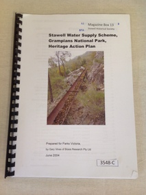 Stawell Historical Society Inc
Book, Gary Vines, Stawell Water Supply Scheme, Grampians National Park, Heritage Action Plan, 2004
White paper with black print and colour photo of a water race. this book has a black plastic bindingStawell Water Supply Scheme, Grampians National Park, Heritage Action Plan. Prepared for Parks Victoria, by Gary Vines of Biosis Research Pty Ltdstawell -
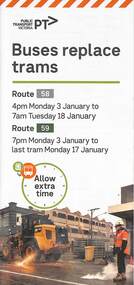 Melbourne Tram Museum
Pamphlet, Yarra Trams, Buses Replace Trams - Routes 58, 59, 86 and 96, 2022
.1 - pamphlet provided at tram stops giving details of the works and bus services for routes 58 and 59 .2 - Project document describing the work and dates - downloaded from the Yarra Trams website after buses were used to replace route 58 from the Royal Children's Hospital rather than from Royal Park Station as originally planned. .3 - as for .1 - for the upgrading of the Merri Creek Bridge - route 86 - see also Reg Item 6066 .4 - as for .1 - for the installation of superstops in Nicholson St between Elgin St and Holden St - route 96Shows the methods that Yarra Trams customers are advised of changes due to track replacement works..1 - Pamphlet - DL, four fold printed on off white paper titled - Buses Replace Trams - Route 58 and Route 59 - Jan 2022 .2 - Project sheet - 3 A4 sheets, titled "Renewal works: Essendon Depot and Mt Alexander Road - 3.1 to 18.1.2022. .3 - Pamphlet - DL 3 fold, Buses Replace Trams, route 86, November 2021 - Merrit Creek Bridge works .4 - Pamphlet - DL - 4 fold, Buses Replace Trams, route 96, January 2020 - Nicholson St works for tram super stops.mt alexander road, tram works, track work, route 58, route 59, yarra trams, ptv, essendon tram depot, route 86, route 96, nicholson st, merri creek, bridges, carlton, super stops, trams, tramways, northcote -
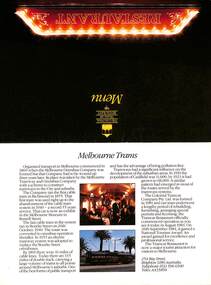 Melbourne Tram Museum
Pamphlet - Colonial Tramcar Restaurant, Colonial Tramcar Restaurant, Menu, 1988
Set of documents associated with the Colonial Tramcar Restaurant that commenced operations in 1982 and ceased in 2018 due to dispute with Yarra Trams over the safety of the tramcars. It was a very popular operation. See reference for further details. Item 1 - notes the September 1984 Tourism Award, item 2 and 3 are promotional pamphlets. The Museum has other similar documents from different dates in its collection. Yields information about the Tramcar Restaurant operation in Melbourne.Set of three documents, full colour on gloss paper, for the "The Colonial Tramcar Restaurant", Melbourne. 1 - Menu - full dinner four course menu, including logos. On the rear is a brief history of Melbourne tramways and the Colonial Tramcar Restaurant itself. Has contact details. 2 - pamphlet with 442 on front cover, advertising the restaurant, the food, seating plan, departure point and the availability of the tramcar. 3 - pamphlet promoting group bookings, general information, contact details including telex and fax numbers. Gives prices from Jan. 1988 and times. tramways, trams, w class, restaurant tram, colonial tramcar restaurant, menu, tram 442