Showing 285756 items matching "streets,roads,melbourne,map,melway"
-
 Camberwell Historical Society
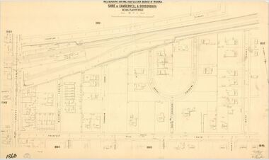
Map (Item) - MMBW map, Melbourne and Metropolitan Board of Works, Melbourne and Metropolitan Board of Works - Shire of Boroondara and Camberwell - Detail Plan no. 1860, August 1904
Lithographer E.H.H., Exd J.W.D, June 1904, No. 70. 40P.15W.melbourne and metropolitan board of works, map, camberwell, cartography -
 Victorian Interpretive Projects Inc.
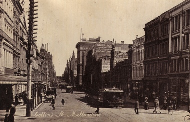
Photograph, Collins Street, Melbourne
Photograph of a postcard showing a streetscape of Melbournes Collins Street.collins street, melbourne, tram -
 Ballan Shire Historical Society
Map - Map. Ballark, Department of Lands and Survey, Ballark. County of Grant, 31/08/1915
A map of the Ballark area within the County of Grant showing roads, waterways, property boundaries and property owners in 1915.Significant to people researching land usage and ownership. Also those researching families in the area at that time.A map of Ballark in the County of Grant. Black printing on buff coloured paper. Extra notations by hand and various coloured highlighting of certain features. Details roads, rivers, property boundaries and names of property owners and districts. The map is easily readable although there is some physical damage to the borders and some sellotape residue. Shows a scale in Chains and the number L.6030Various numbers and directional arrows added to map.bungal, borhoneyghurk, bungeeltap, ballark, beremboke, moreep, meredith, morrisons, moorarbool river -
 Federation University Historical Collection
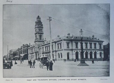
Photograph - Photograph - Black and White, Ballarat Post and Telegraph Office - 1897, 1897
... Sturt and Lydiard Streets, Ballarat, Victoria, Australia ...Early photograph of the Ballarat Post Office taken from the intersection of Sturt and Lydiard Streets. A gas lamp stands in the middle of the intersection. People standing and talking on the roads. The Post Office was built in two sections. Section one built in 1864. Section two and the tower were built in 1885. It was built in the Victorian Italianate design. Arched headed windows on the ground floor originally formed a colonnade. These were filled in to provide more internal space. The tower was a feature - the top having a cast iron balustraded widow's walk.Ballarat Post Office - view north along Lydiard Street from its intersection with Sturt Street. Image taken in 1897. Gas lamp in the middle of the intersection. Numerous people are seen standing in the middle of the road talking. There are wires noticeable but cannot verify if they are electric or for the telephone. Electricity was produced in Dana Street Ballarat as early as 1895post office, gas lamp, overhead wires, tower, arched headed windows, victorian italianate design, widow's walk, ballarat post office -
 Greensborough Historical Society
Map, Melbourne and Metropolitan Board of Works. Survey Division, MMBW, Yarra 2500 / 12.24. Plenty and Blue Lake, 1977_10
Melbourne and Metropolitan Board of Works. Yarra 2500 [base map]. 12-24, Municipalities of Whittlesea 239 and Diamond Valley 257. Shows street names, easement sizes, lot numbers, lodged plan numbers, names of prominent features, contour values, creek or river names. Watsonia Railway Station and environs. Prominent streets: Memorial Drive. Includes Plenty River and Blue Lake in the Plenty Gorge.MMBW Map in 1:2500 [scale] series. Cream parchment with green tape reinforcing on edges and punched holes on left edge.mmbw, melbourne and metropolitan board of works, shire of diamond valley, plenty - maps, blue lake -
 Phillip Island and District Historical Society Inc.
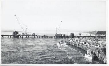
Photographs, Country Roads Board, Construction of 2nd Phillip Island Bridge 1966 - 1969, 1966 - 1969
... Country Roads Board ...Collection of Black & White photographs of the construction of the second Phillip Island Bridge by the Country Roads Board. Contractor John Holland & Co Pty. Ltd.Black & White photographs of the Construction of the Phillip Island 2nd Bridge in 1969 351-01: View from centre of suspension bridge. 351-02: Concreting Pier 8 351-03: Concreting Pier 8 351-04,05 & 06: Metal beams. 351-07: Driving sheet Piling. 351-08:Reinforcement in caisson (watertight structure)351-01: Country Roads Board Victoria, Aust. Negative No. 67-37 - Phillip Island Bridge Project. Shire of Bass 352-02: As above - Negative No. 67-38B 352-03: As above - Negative No. 57-38D. 352-04: Negative No. 67-223A. 352-05: Negative No. 67-223B 352-06: Negative No. 67-223D 352-07: As 352-01-03 plus Negative No. 67-312 352-08: As above - Negative No. 67-272.phillip island bridge (1969), country roads board, sasha stark -
 Port Melbourne Historical & Preservation Society
Programme, Port Melbourne Festival Summer Circus Celebration, Feb 1996
Produced by the Port Melbourne Festival Committee in conjunction with the Bay Street Traders and Circus Oz and distributed throughout the municipality. (From 1996 to 1999 Circus Oz was heavily involved with the Festival, which took place this year at Edwards Park.)Program for Port Melbourne Festival Summer Circus Celebration, 24/25 February 1996: A4, black on cream.arts and entertainment, celebrations fetes and exhibitions, port melbourne festival committee, circus oz -
 Linton and District Historical Society Inc
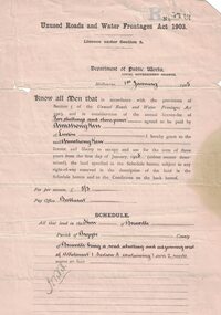
Permit, Permit issued in 1905 under 'Unused Roads and Water Frontages Act, 1903', 1/1/1905
... Permit issued in 1905 under 'Unused Roads and Water ...Licence for use of 11 acres of unused roads in the Shire of Grenville for 3 years at a charge of one pound eighteen shillings and six pence.White oblong paper headed "Unused Roads and Water Frontages Act 1903". Licence number 1767, dated 1st January 1905, issued by Department of Public Works to Armstrong Kerr of Linton. Document is printed on both sides.On back: "2743. A. Kerr".armstrong kerr, agricultural activity, roadside grazing permit -
Port Melbourne Historical & Preservation Society
Booklet, City of Port Melbourne, Port Melbourne Resident's Handbook 1974-1975, 1974
Prepared by the Town Clerk's office of the City of Port Melbourne. Port Melbourne Resident's Handbook for 1974-5, providing details of Council services and other helpful information for residents. Later versions renamed 'Community Directories'. This volume includes a message from Mayor Perce WHITE. (Copy is #795)local government - city of port melbourne, mayors, perce mcguire white, perce white -
 Kew Historical Society Inc
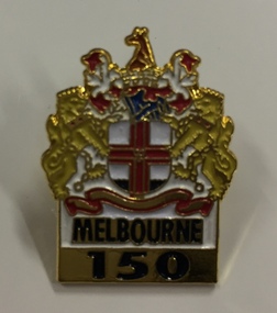
Souvenir, Lapel Pin, Melbourne 150, 1985, 1985
Melbourne 150A lapel pin in the shape of the coat of arms of the City of Melbourne with Melbourne 150 belowMelbourne 150 (front) Pinstop 869 9390 (reverse)melbourne 1834-1984, melbourne - 150th anniversary, souvenirs - lapel pins -
Whitehorse Historical Society Inc.
Document - Correspondence, Roads, 1/06/1932
... Roads ...Correspondence between Maddock, Jamieson & Lonie, solicitors for Mr L. H. Wood and the Shire of Blackburn and Mitcham re purchase of an easement over Wood Street for public use and liability for costs of road construction, Feb - June 1932.wood, l.h., maddocks, jamieson & lonie solicitors, shire of blackburn and mitcham, road construction and maintenance, wood street, nunawading -
 Phillip Island and District Historical Society Inc.
Document, First Annual Meeting minutes of Roads Board 1871
... First Annual Meeting minutes of Roads Board 1871 ...A Phillip Island Road Board was formed in 1871. It was absorbed by Phillip Island and Woolamai Shire in 1874.HistoricalFoolscap photocopy of handwritten minutes of the first annual meeting of the Roads Board, appointing Mr James Forster as Chairman. Also minutes of adjoined general meeting, held later the same day, appointing John Houston was Clerk and all meetings be held at Bauer's Hotel.First annual meeting held at Bauer's hotel on 15 November 1871at 12 o'clocklocal government, roads board, solomon west, james forster, john houston -
 Greensborough Historical Society
Map, Melbourne and Metropolitan Board of Works. Survey Division, MMBW, Yarra 2500 / 13.23. Plenty, Happy Hollow, 1979_03
Melbourne and Metropolitan Board of Works. Yarra 2500 [base map] 13-23. Plenty / Happy Hollow. Parishes of Morang 3183, Nillumbik 3310 and Keelbundora 2856. Municipalities of Diamond Valley 257 and Whittlesea 239. Prominent streets include: McLaughlans Lane and Happy Hollow Drive. Includes Janefield Colony Reserve.MMBW Map in 1:2500 [scale] series. Cream parchment with green tape reinforcing on edges and punched holes on left edge.mmbw, melbourne and metropolitan board of works, shire of diamond valley, plenty - maps, happy hollow -
 Port Melbourne Historical & Preservation Society
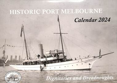
Document - Calendar 2024, Port Melbourne Historical & Preservation Society members, Historic Port Melbourne - Dignitaries and Dreadnoughts, September 2023
Researched, written and designed by PMHPS members.The cover of the 2024 "Historic Port Melbourne - Dignitaries and Dreadnoughts" produced by members of the Port Melbourne Historical & Preservation Society focuses on visits to Port Melbourne by naval shipping and dignitaries including Royal ambassadors. hmas franklin, armed services - navy, shenandoah, koln, idzumo, yakumo, sawagiri, hamayuki, hms hood, hms delphi, duke of york, duchess of york, royal yacht ophir, hms renown, hmas australia, uss seattle, uss nevada, uss oklahoma, great white fleet, hmas canberra, hmas sydney, hmas yarra, piers and wharves - princes pier, piers and wharves - station pier, duke of gloucester, hms sussex, prince alfred, hmcss victoria, hmas lonsdale, hmas perth, anzac squadron, hms king george v -
Federation University Historical Collection
Book, University of Melbourne Matriculation and Junior Commercial Examinations, 1905, 12/1905
University of Melbourne Archives, ref No: 1979.0018, University of Melbourne, Public Examinations Branch, 137 Volumes, Matriculation Examination entries 1855-1903, results and returns 1856-1905, Historical Note describing Matriculation Principal Dates for 1905 from Melbourne University including matriculation.Brown buff paperback book, 106 pages, fold out typewriting exam on page 60. Examinations include Greek, Geometry, Algebra, English, History, French, Grammar, German, Arithmetic, Geography, Chemistry, Physics, Botany, Drawing, Commercial, Bookkeeping, Music, Latin, Physics.university of melbourne, matriculation, examination -
Port Melbourne Historical & Preservation Society
Document, Chain of title for 351 Princes Street, Port Melbourne 1859-2008, 1913 - 1939
Held by Titles Office from 1859 to about 2004. Peter Parrington obtained them after converting title to more common Torrens.Chain of title for 351 Princes Street, Port Melbourne 1859-2008 Conveyance of allotment 14, Section 25, (currently 351 Princes Street) South Melbourne 05.01.1859built environment - domestic, families, dennis ryan, bridget ryan, ryan, stephen, clark street, princes street, john harbison, margaret ryan, b & j howletti, j anderson, n clelland, p j (peter) parrington, s l (sue) parrington -
Hume City Civic Collection
Print - Street Directory, Gregory"s Melbourne Street Directory, c1972
... Streets ...This street directory was published by Gregory's Guides & Maps Pty Ltd of 142 Clarence Street, Sydney NSW in c1972. It was used by the donor's family for many years to navigate their way around Melbourne and the metropolitan area. A street directory enclosed in a black leather detachable cover with gold embossing of a car on the front cover.Gold embossed vintage car on front of detachable cover.joan houston, streets, roads, maps, street directory -
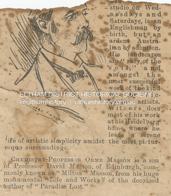 Eltham District Historical Society Inc
Newspaper - Newspaper Clipping, Melbourne Punch, Artist Walter Withers, PEOPLE WE KNOW, Melbourne Punch, June 17, p. 2, 1897
ARTIST WALTER WITHEBS, whose pictures are now on exhibition at his Melbourne studio on Wednesdays and Saturdays, is an Englishman by birth, but an ardent Australian by adoption. His landscapes are "racy of the soil,” and amongst the most successful work of the kind done by Victorian artists. Withers does most of his work at his Heidelberg home, where he leads a serene life of artistic simplicity amidst the most picturesque surroundings. PEOPLE WE KNOW (1897, June 17). Melbourne Punch (Vic. : 1855 - 1900), p. 2. Retrieved August 22, 2023, from http://nla.gov.au/nla.news-article174626232Journal inscribed: "Mrs Withers 463 Collins St. West Melbourne"art exhibition, art review, john withers collection, melbourne, walter withers studio, 463 collins street west, walter herbert withers, artist -
Port Melbourne Historical & Preservation Society
Document - Report, Social and Learning needs in Port Melbourne, South Melbourne and Garden City, Margaret O'Loughlin et al, "Social and Learning needs in Port Melbourne, South Melbourne and Garden City 2006. Port Melbourne Neighbourhood House.", 2006
"Social and Learning needs in Port Melbourne, South Melbourne and Garden City 2006. Port Melbourne Neighbourhood House." Report written by Margaret O'Loughlin and Kate Kelly, based on qualitative, demographic, documentary and statistical data from 2000 and 2005 on the Port Melbourne and South Melbourne neighbourhood and the social and learning needs.education - other, port melbourne neighbourhood house, kate kelly, margaret o'loughlin -
International House, The University of Melbourne
Film (Item), University of Melbourne Experimental Film Unit, Film: International House, Melbourne
This short documentary film was produced by the Melbourne University Film Society in 1954 to display the hopeful possibilities of an International House in Melbourne. It was played from May 4th-6th in the Union House Theatre, along with several other films produced by the Society, possibly scheduled to coincide with the fundraising International House Fair the following weekend. The film stars broadcaster and author Allan Aldous as commentator, and the Malaysian female student is thought to be Rajeswary Thambiah of Malaysia. The female student from Lang Lang is unknown, though may be named Wendy.1950s melbourne, international house -
Whitehorse Historical Society Inc.
Document, McGlone's Estate Mitcham, 1/04/1921 12:00:00 AM
Copy of pamphlet of McGlone's Estate, Mitcham auctioned April 1921.Copy of pamphlet of McGlone's Estate, Mitcham auctioned April 1921. 24 allotments. Bordered by Whitehorse Road, McGlone Street, Station Street and Mitcham railway line and station. Original in Haughton maps, LaTrobe Library.Copy of pamphlet of McGlone's Estate, Mitcham auctioned April 1921. land sales, auctions, mcglone, john, mcglone, elizabeth, whitehorse road, mitcham, mcglone street, mitcham, station street, mitcham, mitcham railway station, haughton map collection, state library of victoria. latrobe library -
 Warrnambool and District Historical Society Inc.
Original Document, Map: Agricultural area of Ballangeich 1865, 1865
George Eddington arrived in Australia in 1839 and named and established property in 1841 calling the property Ballangeich after a Pass near his home town of Stirling in Scotland. It is situated 151 miles west of Melbourne and to the south of Mortlake and was originally part of the Mortlake shire, which was proclaimed 26th Jan 1864. Nearest streams are the Hopkins Riverand Lyall and Drysdale creek running through good agricultural land. This map relates to the breaking up of large runs which the Victorian government enabled through selection acts of the 1860's. The previously larger runs which were mainly cattle and sheep based were now more open to closer settlement and a greater variety in farming.The lots range in size from approximately 50 acres to around 600 acres.Some areas are set aside for reserves. By 1886 the population of Ballangeich had grown to around 600 with an hotel, three state schools and a church.Tri weekly coaches ran to Colac, Warrnambool and Camperdown providing access to supplies mail and communication. This map is typical of many which were produced in the 1860's in Victoria during a significant period of Victoria's and Warrnambool district history.Rectangular light card paper with black text showing allotments of land The area is coloured in green with scale at bottom right cornerAt the top: Plan of the Agricultural area of Ballangeich 1865 At the bottom left: Prepared by the Board of Lands & Works in accordance with the Amending Land Act 1865 Lands & Survey Office Melbourne 13th April 1865. With signaturehistory of warrnambool, ballangeich, land surveys victoria 1865, lands act 1865 victoria, ballangeich map 1865 -
Port Melbourne Historical & Preservation Society
Magazine, Port Melbourne Football Club, The Burras 1988, Port Melbourne Football Club, 1988
"The Burras 1988, Port Melbourne Football Club". Magazine front cover has a red strip at top and blue strip along bottom. Between these is a black and white grainy photo of two players jumping for the ball. Back cover has a coloured advertisement for HDT vehicle specialists. Page of club information followed by page of local advertisments.sport - australian rules football, port melbourne football club, pmfc, alexander arthur james, woodruff farms pty ltd, olympia bay street cellars and foodmart, kevin hoare, idol sport -
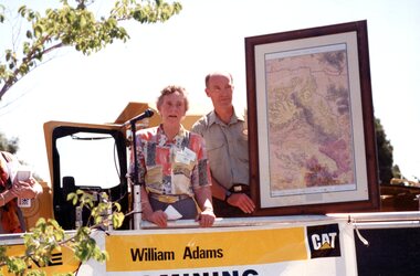 Stawell Historical Society Inc
Photograph, Gold Fields Map Presentation to the Stawell Historical Society, 2001
Gold Fields Map Presentation to SHS.Three (3) Colour Photographs 1: SHS President Betty Jackson presented with goldfields map. by goldfoelds manager, Richard Carlton. 2: Mayor Karen Douglas, with Betty Jackson and Richard Carlton 3: Mayor Karen Douglas presenting colouring competition to School childrenstawell -
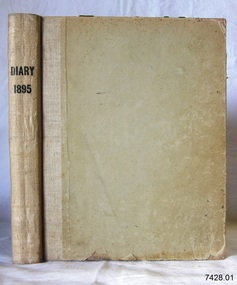 Flagstaff Hill Maritime Museum and Village
Book - Diary, Sands & McDougall Limited, Diary 1895, ca. 1895
... Corner Timor and Kepler Streets, Warrnambool, Victoria ...This Bank Manager’s Diary is one of a set of five Bank of Australasia, Warrnambool branch, diaries that span the years 1895 to 1899. A Butt was Manager from 1895-1904 and J R McCleary was Accountant and Acting Manager for 12 months, until 1900. Either or both of these men could have filled in the bank’s Diary. This diary cost five shillings (5//-). Each of the diaries in the set was manufactured by the famous Melbourne stationers, Sands & Mc Dougall Limited. The business was established as a printing partnership in 1851 by John Sands and his brother-in-law Thomas Kenny, and in 1860 Dugald McDougal joined them. The firm was re-named Sands & McDougall a year later after Kenny retired. The company was renowned as stationers, booksellers, printers and account book manufacturers and by the 1870s was one of the largest businesses in Australia. The Bank of Australasia was incorporated by Royal Charter of England in March 1834. It had its Australian beginning on 14th December 1835, opening in Sydney. The Acting Superintendent of the bank at that time was David Charters McArthur. He was Superintendent from 1867 to 1876. The Melbourne branch opened on 28th August 1838 in a two-roomed brick cottage on the north side of Little Collins Street. By 1879 the bank had been upgraded to a magnificent two-storey building on the corners of Collins and Queens Streets, with the entry on Collins Street In 1951 the Bank of Australasia amalgamated with the Union Bank to form the Australia and New Zealand Bank, now known as the ANZ. Then in 1970, the ANZ merged with both the ES&A and the London Bank of Australia to form the ANZ Banking Group Limited. The ANZ Banking Group Ltd kindly donated a variety of historic items from the Bank of Australasia. BANK of AUSTRALASIA, WARRNAMBOOL – In 1854 Warrnambool had two banks, the Union Bank and the Bank of Australasia. Later, completely different bank businesses opened; in 1867 the National Bank of Australasia, then in 1875 the Colonial Bank of Australasia. The original Warrnambool branch of the Bank of Australasia was established in July 1854, and operated from a leased cottage on Merri Street, close to Liebig Street. The bank next bought a stone building previously erected by drapers Cramond & Dickson on the corner of Timor and Gibson Streets. Samuel Hannaford was a teller and then Manager at the Warrnambool branch from 1855 to 1856 and the Warrnambool Council chose that bank for its dealings during 1856-57. In 1859 Roberts & Co. was awarded the contract to build the new Bank of Australasia branch for the sum of £3,000; the firm built the Warrnambool Post Office in 1856 and purchased land in Timor Street in 1858. The land was on a sand hill on the northeast corner of Timor and Kepler Streets and had been bought in 1855 by investor James Cust. The new building opened on May 21, 1860. The bank continued to operate there until 1951 when it merged with the Union Bank to form the ANZ Bank, which continued operating from its Liebig Street building. Warrnambool City Council purchased the former Bank of Australasia building in 1971 and renovated it, then on 3rd December 1973 it was officially opened as the Art Gallery by Cr. Harold Stephenson and Gallery Director John Welsh. The Gallery transferred to the purpose-built building in Liebig Street in 1986 and the old bank building is now the Gallery club. Staff at the Bank of Australasia in Warrnambool included the following men but others were also involved: Samuel Hannaford, Teller then Manager from 1855-1856; Hawkins, Manager in 1856, W H Palmer, Manager from January 1857 until November 1869 when the Teller Basil Spence was promoted to Manager; H B Chomley, Manager from April 1873 and still there in 1886; A Butt, Manager in 1895-1904; J R McCleary Accountant and Acting Manager for 12 months, until 1900; A Kirk, Manager 1904; J Moore, staff until his transfer to Bendigo in December 1908; J S Bath was Manager until 1915; C C Cox, Manager until April 1923; Richard C Stanley, Manager 1923 to April 1928. The set of diaries has significance through its association with the Bank of Australasia. The early Australian bank was established in 1834 by Royal Charter and opened in Sydney, Australia, in Sydney in 1835. The bank had many Australian offices in November 1877, particularly on the east and south coasts. Victoria had 45 per cent of all Offices. The set of diaries is locally significant for its association with the Warrnambool Bank of Australasia, which was established in 1854. It was Warrnambool Council’s first bank. The bank continued to operate until the organisation's merger in 1951 when it became the ANZ Bank Group today. The Bank was an integral part of the growth of local commerce and the community.Bank Manager's Diary, 1895. One of a set of five diaries of the Bank of Australasia, Warrnambool, from 1895 to 1899. The front endpper has a pencil inscription and printed label attached. Manufactured by Sands McDougall Limited, Melbourne.Printed on spine "DIARY / 1895" Printed on label in blue ink "NO. __ Date __ 18 __ / Sands & McDougall Limited / Manufacturing Stationers / 365 Collins Street / Melbourne" "IN RE-ORDERING THIS BOOK IT IS NECESSARY THE NO. & DATE ONLY" In pencil "R- - - - - 5/-" [Five shillings]flagstaff hill, warrnambool, shipwrecked coast, flagstaff hill maritime museum, maritime museum, shipwreck coast, flagstaff hill maritime village, great ocean road, bank of australasia, boa, union bank, australia & new zealand bank, anz bank, commerce, david charters mcarthur, d c mcarthur, bank of australasia warrnambool, sands & mcdougall, diary, set of 5 diaries 1895-1899, 1895, samuel hannaford, w h palmer, basil spence, h b chomley, a butt, j r mccleary, a kirk, j moore, j s bath, c c cox, richard c stanley -
Whitehorse Historical Society Inc.
Document, Roads, 1/03/1937
... Roads ...Claim by Shire of Blackburn and Mitcham for reimbursement from Country Roads Board for amounts expended on the Main Healesville Road (now Whitehorse Road), March 1937.healesville road, roads and streets, victoria. country roads board, shire of blackburn and mitcham, whitehorse road, nunawading -
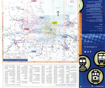 Melbourne Tram Museum
Map, Department of Infrastructure (DOI), "Melbourne's Public Transport Map", Jul. 1999
Map - 18 fold - 6 x 3 with colour map of public transport including buses, titled "Melbourne's Public Transport Map", published by the Department of Infrastructure, Effective July 1999. Gives rail and tram maps, information on tickets, zones (3 Number) Has The Met contact details and website. Has DOI and State Govt logos. Priced $2.trams, tramways, map, doi, melbourne, the met -
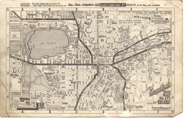 Ballarat Tramway Museum
Map, Broadbent's, "Broadbent's Official Map 177 Ballarat", c1960
Printed street map titled "Broadbent's Official Map 177 Ballarat" on a medium weight (200gsm?) card. Shows the suburbs of Ballarat, but not Sebastopol, rail lines and tram routes, schools, some churches, hospitals, parks and some features. Does not show the full length of the Lydiard St or Sebastopol tram lines. Has scale, national route numbers and distance from Ballarat PO marked on the map. In bottom left hand corner, has Broadbent's north point logo and notes that it is the 66th year of publication of road maps. Gives telephone number as MB 2021 in top right hand corner.Initials "GY" in pencil and red ink in top right hand corner.trams, tramways, map, ballarat, broadbent's, railways -
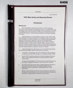 Bendigo Military Museum
Administrative record - DIGO Map Library and Repromat Review 2004, Geospatial Analysis Centre, Bendigo, 25 Oct 2004
Prior to the digital revolution the only medium by which cartographic information could be reproduced and distributed on mass was via printed media. The final negatives (repromat) used to produce the printed products were the culmination of a complex cartographic process and were therefore carefully preserved and stored. Preservation of the so-called final negatives enabled subsequent reprinting with minimal cartographic intervention. Since the arrival of the Land Headquarters Cartographic Company at Fortuna in 1942 the repromat for all products produced by the Australian Survey Corps were carefully stored. With the disbandment of the Army Survey Regiment in 1996 the Defence Imagery and Geospatial Organisation (DIGO) inherited that repromat archive. It was immanent that the support for film based printing was ending so on 25 October 2004 a review was required to determine the way ahead for the repromat and paper maps stored in the DIGO Map Libraries. Most of these maps were produced by the Royal Australian Survey Corps. This report is the result of that review. The report recommends the disposal of the repromat and the retention of single map copies. A4 plastic covered report, plastic clip bound, front page clear and rear page red. 9 x page document about the future of repromat and map printing.royal australian survey corps, rasvy, fortuna, army survey regiment, army svy regt, asr -
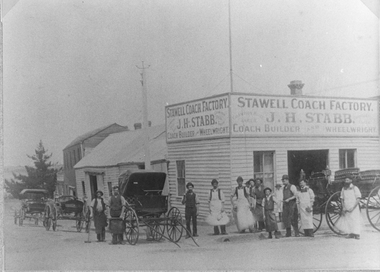 Stawell Historical Society Inc
Photograph, Stabb and Fair Coachbuilders Corner of Main and Wimmera Streets Stawell 1890's, C 1890's
... Streets Stawell 1890's ...Sepia Photograph of Stabb and Fair Coachbuilders Corner of Main and Wimmera Streets. Row of workmen and horse drawn coaches in the street. 1890's. This buisness was started by Mr. Aldred, who came to Stawell in 1874. Mr Stabb had served his apprenticeship in Ballarat with mr Aldred. Some time later Mr Stabb took over.Sepia Photograph of a weatherboard factory with a row of workmen and horse drawn vechicles i the street.Sign above the Factory. STAWELL COACH FACTORY J.H. STABB COACH BUILDER WHEELWRIGHT on both sides of stawell industry, j.h. stabb, coach builder