Showing 667 items matching "survey plan"
-
 Bendigo Historical Society Inc.
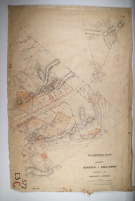
Map - BOROUGH OF EAGLEHAWK RE-SURVEY, 6/06/1883
Map: Re-survey, Borough of Eaglhawk, Parishes of Nerring and Sandhurst, Sheet No. 1. Parish planmap, bendigo, re-survey, borough of eaglehawk, re-survey -
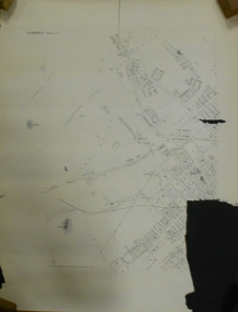
 University of Melbourne, Burnley Campus Archives
Plan, Grace Park Feature Plan, 1901-1983
(1) City of Hawthorn plan dated August 1983. Drawing No P12/24 Sheet 1 of 1. Surveyed: L.B. & H.K. Traced H.K. Scale 1:500. (2) Photocopy of map of area, Grace Park coloured in. 1901 handwritten on page.hawthorn, grace park -
Bendigo Historical Society Inc.
Map - SECTIONS ACROSS BENDIGO GOLDFIELD
Map in three sections showing sections across Bendigo Gold Field, showing anticlines, synclines, faults, stratigraphical zones and mines along the reef lines. Key shows rock types Castlemaine, Bendigo B1, B2, B3 and B4, and Lancefieldian. First part of map shows sections A-A, B-B and C-C. Reef lines drawn with mines listed: Fault line shown are the Carshalton, Stafford, New Chum, Virginia and Clarence. A datum line shows 600 ft above sea level. On bottom of plan: ' Prepared in the Geological Survey Office, Bendigo, under the direction of H. Herman, late Director of Geological Survey, from surveys by H.S. Whitelaw, Field Geologist, assisted by E.S. Usher, A.J.J. Moore and R.A. Keble.' Second section of map shows sections D-D, and E-E. Fault lines listed are the Tambour Major fault, Carshalton fault, Stafford fault, Nell Gwynne fault, New Chum fault, Deborah fault. Third section shows sections F-F and G-G. Fault lines listed are the Bird Reef fault, Kangaroo Gully fault, Langdon fault, Carshalton fault, Nell Gwynne fault, Spring Gully fault, Hustlers fault, Gravel Hill fault, Ordes fault, Thanet fault. This map forms part of the Geological Survey of Victoria, Structure of Bendigo Goldfield report, No. 47, 1923. H.Herman, late Director of Geological Survey.Geological Survey of Victoriabendigo, gold mining, reef line maps -
 Flagstaff Hill Maritime Museum and Village
Map - Survey Map, F.F. McGovern, Yangery - County of Villiers, 1884
A surveyor was employed to measure the land designated as Yangery, County of Villiers, in the Borough of Warrnambool. The area on the map is similar to the earlier Farnham Survey undertaken by William Rutledge in the 1850's. Warrnambool was a Borough between 1863-1883. Coutours, waterways, sea and other significant points are shown. The distances are accurately measured. This survey map was used for planning future land sales, recreation areas and roads. WILLIAM RUTLEDGE (1806-1876) William Rutledge surveyed the land known as Farnham in southwest Victoria in 1843. His tenants made him a profitable business from working the land there. In 1863 Rutledge moved from nearby Port Fairy to Farnham and became very successful in breeding sheep, which he imported from J.R. Kirkham of Lincolnshire, England. He also bred horses on his land. The survey map of Yangery is important for its connection with renowned surveyor William Rutledge. The map shows the growth of landholders in the district when compared to the original Rutledge survey of the 1850's.Survey map of Yangery, titled "Yangery - County of Villiers". Printed on white paper, mounted on brown paper. c. 1863-1876. Comments printed on the Map include; Special Survey by William Rutledge, Photo-lithographed at the Department of Lands and Survey, Melbourne by W.J. Burson, Price 1/- [one shilling]. Scale is in Chains. Map has boundaries of Koroit Borough, Meerai, Purnim, Wangoom, Borough of Warrnambool, Mentions the Proposal of Tower HIll for Public Recreation. The map names the owners of the land at that time. Hand written pencil marks and figures and "Sauls fence" drawn on map. Hand written pencil markes and figures and "Sauls fence" drawn onto map. "For Department Use only". "Scale: 8 chains to 1 inch" flagstaff hill, warrnambool, shipwrecked-coast, flagstaff-hill, flagstaff-hill-maritime-museum, maritime-museum, shipwreck-coast, flagstaff-hill-maritime-village, county of villiers map, yangery district, w.j. burson, borough of warrnambool, koroit, purnim, meerai, wangoom, proposal of tower hill for public recreation, special survey by william rutledge, william rutledge, farnham, lincolnshire sheep, clydesdale -
 Federation University Historical Collection
Map, Ballaarat Gold Field, 1861, 1861
A party of surveyors camped by Yuille's Swamp (later Lake Wendouree) and surveyed the countryside for a map to be produced by the Geological Survey of Victoria. In November 2004 the Central Highlands Regional Library presented a special edition of 200 copies of the 1861 map reproduced from a copy in their collection. Original 1861 map of Ballarat showing streets and leads. Blue dots indicate gold leads, and red lines indicate auriferous quartz reef and outcrops of quartz veins."Compiled & Drawn from the Survey of Mining Surveyors Davidson, Fitzpatrick and Cowan & the Plans in the Surveyor General's Office by J. Brahe, 21st October 1861. R. Brough Smyth, Secretary for Mines. The Honourable J.B. Humffray, M.L.A. Commr of Mines.”ballarat, map, ballarat east, lake wendouree, survey, mines, robert davidson, ballarat gold field 1861, yuille's swamp, wendouree swamp, little bendigo diggings, gold leads, old post office hill, specimen hill, bakery hill, black hill, dead horse creek, brown hill, pennyweight hill, clayton hill, soldiers hill, golden point, gum tree flat, white flat, poverty hill, chinese village, robert brough smyth, ballarat map 1861, ballaarat vineyard, dead horse gully, deadhorse creek, invermay, black hill flat, gaelic church, police reserve, magpie range, dalton's flat, caadian lead, rifle butts, powder magazine, bathing house, government camp, gold office, chinese, llanberrris, victoria theatre, charlie napier hotel, united states hotel, grape's hoel, clayton's hill, cattleyard hill, free trade hotel, esmond lead, bakery hill, black hill lead, juvenile reformatory, ballarat orphanage, lady barkly lead, triffet's slaughter yard, little bendigo, melbourne road, t. cowan, thomas cowan -
Bendigo Historical Society Inc.
Map - PLAN OF VICTORIA HILL AREA, 1971
BHS CollectionBendigo Historical Society feature Plan of the Victoria Hill area. Printed on Paper and laminated. B & W. Compiled by AHG Survey Regiment.CMF Increment May 1971bendigo, gold mining, victoria hill -
Bendigo Historical Society Inc.
Map - PLAN OF VICTORIA HILL AREA, 1971
BHS CollectionBendigo Historical Society feature Plan of the Victoria Hill area. Printed on Paper. B & W. Compiled by AHG Survey Regiment.CMF Increment May 1971bendigo, gold mining, victoria hill -
Bendigo Historical Society Inc.
Map - PLAN OF VICTORIA HILL AREA, 1971
BHS CollectionBendigo Historical Society feature Plan of the Victoria Hill area. Printed on Acetate. B & W. Compiled by AHG Survey Regiment.CMF Increment May 1971bendigo, gold mining, victoria hill -
 Melbourne Tram Museum
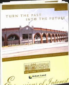
Document - Folder with papers, Urban Land corporation, "Hawthorn Tram Depot - Expressions of Interest Documentation", late 1998
White two spring clip folder with papers, titled "Hawthorn Tram Depot - Expressions of Interest Documentation", sub-titled "Turn the Past into the Future" Has a photo of Hawthorn Tram depot and an image on the front cover. Closing date 17/2/1999, prepared by the Urban Land Corporation with the assistance of VicTrack. Approx 110 pages with supplementary papers in the end covers. Contains a table of contents, checklist, EOI Process, Development Brief, Site conditions. Gives details of the heritage registration, site plans, building plans, property title and detailed room condition and use of the ground floor. Supplementary papers include the marketing brochure, letters and a detail feature and level survey by Bosco Johnson surveyors, 30-9-1998.trams, tramways, htt, hawthorn tram depot, sale of land, property -
 Melbourne Tram Museum
Pamphlet, Public Transport Victoria (PTV), "Help plan your future tram services", Jun. 2015
Set of two documents - pamphlets to ask passengers about the changes to routes 1, 6, 8 and 55 - 2015. .1 - 3 fold pamphlet, DL size colour on off white paper titled .1 - "Help plan your future tram services" asking feedback via an on-line survey. Shows the possible route changes on a map and basis of the changes. Has contact details on the rear. Two copies held. .2 -DL sheet cut for hanging within a tram, titled "Have your say on proposed changes to these routes - 1, 6, 8, 55, noting that a brochure could be picked up on the tram. Have PTV, Yarra Trams and Vic. Govt. logos.trams, tramways, route 1, route 6, route 8, route 55, route 58, tram routes -
 Melbourne Tram Museum
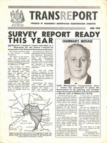
Pamphlet, Minister of Transport, Transport, Jun. 1968
Transport - produced by Melbourne's Metropolitan Transportation Committee. 4 page brochure describing Melbourne's transport survey - "Blue-print for the Future".trams, tramways, reports, planning -
 Melbourne Tram Museum
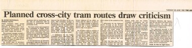
Newspaper, The Age, "Planned cross - city tram routes draw criticism", "Coalition pledges efficiency review of tramways plan", "System hit by years of Neglect" "A new tramway game of nought's and crosses", 14/06/1992 12:00:00 AM
Set of three Newspaper clippings about the proposed cross linking of Melbourne tram routes, written by Jacqui Macdonald and Claude Forrell. .1 - The Age, 30/6/1992 - by Jacqui Macdonald, titled "Planned cross - city tram routes draw criticism", PTC review, W class trams, conductors, PTUA Patrick O'Connor, National Trust David Clark, Opposition Alan Brown and Peter Spyker all commented. Noted by one body a lack of research and surveys. .2 - The Age 1/7/1992 - two items - "Coalition pledges efficiency review of tramways plan", about the plan prepared by the Strategic Review Committee chaired by Peter Parkinson, workplace reforms, cross linking of tram routes, release of the review report the previous day by Peter Spyker. Also quotes Union Secretary Lou DiGregorio and PTUA. The second item - "System hit by years of Neglect" - comments about the report and The Met ticket dispute. Item has a map showing the proposed routes. .3 - The Age 1/7/1992 - "A new tramway game of nought's and crosses" - Claude Forrell - looking at the savings of the plan, conductors, union consent, Government and Coalition attitudes to the proposal of cross linking routes. finances.trams, tramways, operations, transport, public transport, unions, finances, maps, tram routes, w class, national trust, ptua, conductors -
 Melbourne Tram Museum
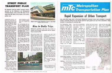
Pamphlet, The Metropolitan Transportation Committee, "Metropolitan Transportation Plan - Rapid Expansion of Urban Transport", c1968-69
Pamphlet full colour, four pages, printed on off white paper titled "Metropolitan Transportation Plan - Rapid Expansion of Urban Transport", issued by the Metropolitan Transportation Committee, c1968 - 69, explaining the planning of the Committee for Melbourne's transport in 1985. Looks at the future of Melbourne's rail, bus, tram and road network. Includes the survey and implementation. See Reg Item 623 for part of the final plan.trams, tramways, melbourne, road transport, tramways, railways, public transport, transportation plan -
 Melbourne Tram Museum
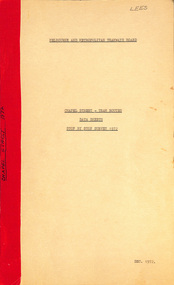
Document - Report, Melbourne & Metropolitan Tramways Board (MMTB), "Chapel Street - Tram Routes - Data Sheets - Stop by Stop survey 1972", Dec. 1972
Report - Foolscap, card covers, red tape binding, 10 pages, titled "Chapel Street - Tram Routes - Data Sheets - Stop by Stop survey 1972" Maps running times and summary including a check across conductors journals. Dated Dec 1972, notes work done by L Hogan, W. TootellHas "Lees" in the top right hand corner and the title on the left side of the report.trams, tramways, routes, passengers, planning, development, chapel st -
Canterbury History Group
Document - Frognall - History, Royal Australian Air Force
Photocopy of a 38 page booklet compiled by Royal Australian Air Force Engineers Cadet Squadron , includes maps, house floor plan, photographs and footnotescanterbury, royal australian air force engineers cadet squadron, hicks> clarence, laycock> burdett, frognall, mont albert road, maps, elgar's special survey -
Villa Alba Museum
Document, Andrew Thorn, Villa Alba: Condition Survey and Stabilization of Critical Surfaces, 1997
This report was commissioned by the Villa Alba Preservation Committee following evidence of deterioration on a number of important surfaces at Villa Alba. The report documents changes that have occurred and compares them to the situation reported on in 1986. The report then outlines treatments carried out in 1986 and recently for each of the rooms worked on in 1986.36-page conservation report conducted by Andrew Thorn (Artcare) in 1997 of surfaces in Villa Alba. The report has the following structure: Condition Survey, Treatment Materials and Methods, Detailed Work in Each Room. This copy of the draft report includes detailed plans showing areas requiring stabilization.This report was commissioned by the Villa Alba Preservation Committee following evidence of deterioration on a number of important surfaces at Villa Alba. The report documents changes that have occurred and compares them to the situation reported on in 1986. The report then outlines treatments carried out in 1986 and recently for each of the rooms worked on in 1986. villa alba museum, conservation reports, andrew thorn, artcare, conservation treatments -
Villa Alba Museum
Document, Maddy Maitri (Maitri Archaeology), Villa Alba Landscape Reconstruction: Archaeological Test Excavations Phase 2, 2002
... of landscape features identified in historical plans, photographs ...This document documents the results of archaeological excavations conducted within the grounds of Villa Alba in Kew, by Maddy Maitri (Maitri Archaeology) in October 2002. The testing was conducted as part of the design development stage of a proposed landscape reconstruction. The broad aim of subsurface testing at Villa Alba was to determine the presence, location and depth below ground of archaeological remains relating to a number of landscape features identified in historical plans, photographs, survey field books and aerial photographs. This information would then be used by the landscape architect in the development of a design which approximates the 1880s/1890s landscape of Villa Alba.Contents: Acknowledgements / Abbreviations / List of figures / List of tables / List of plates / Introduction / Historical context / Methodology / Results and interpretations / Discussion / Recommendations / References / Appendix 1 - Plates / Appendix 2 - Content list / Appendix 3 - Copy of Heritage Victoria permit. This document documents the results of archaeological excavations conducted within the grounds of Villa Alba in Kew, by Maddy Maitri (Maitri Archaeology) in October 2002. The testing was conducted as part of the design development stage of a proposed landscape reconstruction. The broad aim of subsurface testing at Villa Alba was to determine the presence, location and depth below ground of archaeological remains relating to a number of landscape features identified in historical plans, photographs, survey field books and aerial photographs. This information would then be used by the landscape architect in the development of a design which approximates the 1880s/1890s landscape of Villa Alba.villa alba - archaeology, villa alba - garden reconstruction, 2002 -
Villa Alba Museum
Document, Villa Alba Museum Archaeological Test Excavations, 2002
... plans, photographs, survey field books and aerial photographs ...A preliminary report on archaeological test excavations, conducted on 5 & 7 September 2002 by Maddy Atkinson (Ripple Arc). The purpose of the excavations was twofold. Firstly, to conduct subsurface testing at Villa Alba to determine the presence, location and depth below ground of archaeological remains relating to a number of landscape features identified in historical plans, photographs, survey field books and aerial photographs. Secondly, soils surrounding the Villa Alba mansion, which have been found to be contaminated with lead will need to be removed up to a depth of up to 0.6 metres. Removal of deposits from the site may have an adverse impact on any archaeological remains existing below the surface.Contents: Acknowledgements / Abbreviations / List of figures / List of tables / List of plates / Introduction / Historical context / Methodology / Results and interpretations / Discussion / Recommendations / References / Appendix 1 - Plates / Appendix 2 - Content list / Appendix 3 - Copy of Heritage Victoria permit.non-fictionA preliminary report on archaeological test excavations, conducted on 5 & 7 September 2002 by Maddy Atkinson (Ripple Arc). The purpose of the excavations was twofold. Firstly, to conduct subsurface testing at Villa Alba to determine the presence, location and depth below ground of archaeological remains relating to a number of landscape features identified in historical plans, photographs, survey field books and aerial photographs. Secondly, soils surrounding the Villa Alba mansion, which have been found to be contaminated with lead will need to be removed up to a depth of up to 0.6 metres. Removal of deposits from the site may have an adverse impact on any archaeological remains existing below the surface. conservation studies, conservation reports, archaeological reports, villa alba museum -
 Ringwood and District Historical Society
Map - Plans of Subdivision, Part of Crown Allotments 35 & 39, Parish of Warrandyte
Survey maps of stages 1, 2 & 3 of residential allotments in Kalinda Road and Grayling Crescent, Ringwood, Victoria. (Undated, circa 1960). Some allotments are marked with real estate information and prices in pre decimal £s.Adshead & McGuire, Land Surveyors L.S. M.I.S. (Aust), 268 Albert Street East Melbourne (Ref 118/2a b &c) Tel 41-6960. The land colored blue is set apart for drainage & sewerage purposes. Reference Marks (R.M's) are Gal Iron Pipes 12"x1". Levels shown are to M.M.B.W. Datum. The land shown hatched is subject to innundation. -
Ballarat Tramway Museum
Document, Hector Bell Junior, "Street passenger transport system of Geelong Urban Area", 1949
... , functions of a street transport authority, town planning..., functions of a street transport authority, town planning ...Report by Hector H Bell Junior of the MMTB early 1949, titled "Street passenger transport system of Geelong Urban Area". Looks at the history of public transport in Geelong, tramway data, financial analysis, the Geelong bus system, buses servicing the North Shore industries - principally the Ford Works, the condition of the bus fleet, taxi and private car hire services, functions of a street transport authority, town planning, populations and traffic surveys, relative values of passenger vehicles, trolley buses, industry and recommendations. Said the tramway system was obsolete, should be a rail service between North and South Geelong, set up a street transport body, replan the Geelong railway station, additional roads to service the North Shore area. Refers to attachments. Has a list of people involved in the preparation of the report. See item 112 for the AETA response of April 1949 to this report.Yields information about the Geelong tram and bus services in 1948/49 and how it could be developed or reformed. Has a close association with Hector Bell Junior, the son of the then MMTB Chairman.Document - 18 foolscap sheets photocopied and stapled in three places along the side.tramways, secv, geelong, statistics, history, passenger services, reports, aeta -
 Bendigo Historical Society Inc.
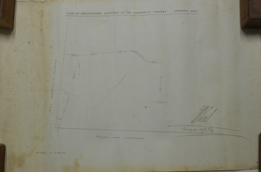
Plan - MARKS COLLECTION: PLAN OF UNDERGROUND WORKINGS CINDERELLA COMPANY, JOHNSON'S REEF
... BENDIGO Mining cinderella company Plan on heavy parchment ...Plan on heavy parchment paper: on top of plan 'Plan of the underground workings Cinderella Company, Johnson's Reef' Lh side of plan 'Kent Company's Ground' on bottom: Tipper and Company. Written on bottom surveyed 13/7/64.bendigo, mining, cinderella company -
 Bendigo Historical Society Inc.
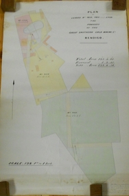
Plan - MARKS COLLECTION: LEASE PLANS GREAT SOUTHERN GOLD MINE BENDIGO
... Lease Plans and from actual survey' Signed E.F Brown... was devised from Government Mining Lease Plans and from actual survey ...Plan on heavy paper, tightly rolled. On top of plan "Plan of Leases 5429, 4810, 4811 and 5429", The Property of the Great Southern Gold Mining Co. Bendigo' \Total area123 acres, 3 roods, 33 perches, excised, nett area 122, 0. 38. On bottom '32 feet to one inch' and 'This plan was devised from Government Mining Lease Plans and from actual survey' Signed E.F Brown, certificated mining and authorised surveyor 25/6/87' Leases No. 5429 and 4810 details location of shaft, tramway, battery, engine house and boiler. Large mining dam outlined.bendigo, mining, great southern gold mine -
 Bendigo Historical Society Inc.
Document - MARKS COLLECTION: PLAN OF SANDHURST CITY CENTRE AND SURROUNDING AREA ( NO. 1 )
Plan on heavy parchment - section neatly cut out of area now Kennington. Written on plan in black print ' Sheet No. 1. Sandhurst'. Plan shows Government Camp, Commissioner's Gully, old cemetery site, manure depot, cattle market, Benevolent Asylum Reserve, railway reserve. Landowners' names on allotments. On bottom lithographed at the Department of Lands and Survey, Melbourne, by D. Henerson, March 12th., 1867 Plan part of George Lansell, Fortuna auction, documents found in wardrobe purchased by Marks family in 1930's.bendigo, planning, sandhurst 1867 -
 Bendigo Historical Society Inc.
Document - MARKS COLLECTION: UNDERGROUND SURVEY OF MINES NEW CHUM LINE OF REEFS
Plan, in two sections, on heavy parchment coloured paper. Printed across top in black ink 'Underground Survey of Mines New Chum Line of Reefs' a. Shows cross section of mine, b. longitudinal section. Drawn by Arthur Everett, Mining Department, Melbourne 1884. Surveyed by Caleb Thomas under the direction of Charles Langtree. Plan found in George Lansell auction items. Plan found in George Lansell items sold at auction.bendigo, mining, new chum reef -
 Bendigo Historical Society Inc.
Plan - MARKS COLLECTION: UNDERGROUND SURVEY OF MINES SANDHURST NEW CHUM LINE OF REEF
... , 1884. Plan MARKS COLLECTION: UNDERGROUND SURVEY OF MINES ...Plan, divided into two sheets, on top of sheet Underground survey of mines Sandhurst, New Chum Line of Reef. Surveyed by Caleb Thomas under the direction of Charles W. Langtree, Acting Secretary for Mines and Water Supply and Acting Chief Mining Surveyor for the Colony of Victoria. Drawn by Arthur Everett, Mining Department, Melbourne, 1884.bendigo, mining, new chum line of reef -
 Bendigo Historical Society Inc.
Map - LANSELL'S BIG 180 MINE - LOCALITY OF LANSELL'S NO 180 SHAFT
Buff coloured photocopy of the location of Lansell's No 180 Shaft and showing the positions of Underground Workings near the intersection of Lily St and Alley St. Also mentioned are the North Old Chum Shaft and the New Chum and Victoria Co Shaft. Luffman Brothers has been written in in pen and initialled A R. Printed at the bottom is: Surveyed by E. T. Brown, under the direction of A. W. Howitt, Secretary for Mines for the - (the rest is cut off).map, bendigo, mining plan, lansell's big 180 mine, locality of lansell's no 180 shaft, north old chum co shaft, new chum and victoria co shaft, luffman brothers, e t brown, a w howitt -
 Bendigo Historical Society Inc.
Document - MARKS COLLECTION: PLAN OF SANDHURST CITY CENTRE AND SURROUNDING AREA ( NO. 2 )
Plan drawn on heavy parchment. Written on plan Sandhurst Sheet No. 2. (See record 8300.58 for continuation of plan into city centre) Plan shows allotments with owner names, where applicable. Quartz crushing machines marked. On bottom lithographed at the Department of Lands and Survey, Melbourne, by D. Henerson, March 12th., 1867. There is also a photocopy.bendigo, planning, sandhurst -
Lakes Entrance Historical Society
Book, Central Planning Authority, Victoria, Resources Survey East Gippsland Region, 1954
A review of the physical, economic, and public resources of East Gippsland, Victoria.primary industry -
 Bacchus Marsh & District Historical Society
Map, Mooradoranook Parish Map, County of Grant
A single page paper map showing the map for the Parish of Mooradanook in the County of Grant. Cadastral map showing land ownership. The map is pasted into a bound volume containing 76 maps or plans in total. High resolution digital image stored on BMDHS computer network. Photo lithographed at the Department of Lands and Survey Melbourne by T. F. McGauran, 27.11.06mooradoranook parish maps, mooradoranook parish plan, bacchus marsh region parish plans -
 Bacchus Marsh & District Historical Society
Map, Mouyong Parish Map, County of Grant
A single page paper map showing the map for the Parish of Mouyong in the County of Grant. Cadastral map showing land ownership. The map is pasted into a bound volume containing 76 maps or plans in total. High resolution digital image stored on BMDHS computer network. Photo lithographed at the Department of Lands and Survey Melbourne by T. F. McGauran, 9. 4. 07mouyong parish plan, mouyong parish maps, bacchus marsh region parish plans