Showing 862 items matching "surveyors"
-
 Wodonga & District Historical Society Inc
Functional object - Seal - Police Office, Belvoir
This seal was used for official police and court documents by the Belvoir Police Office.The initial land survey for the city now known as Wodonga was first undertaken in 1852 by Thomas Wedge - Assistant Surveyor. The new township was called "Belvoir" and was proclaimed by that name in 1852 and again in 1861. The first sale of land in Belvoir was held at Wangaratta on April 28, 1854, when all the allotments surveyed by Thomas Wedge (excepting those set apart for reserves, government and public areas) were offered at auction. Following representations by the Postmaster General on June 23, 1869, the Governor in Council, on July 12, 1869, approved of its Aboriginal name "Wodonga" being restored. The seal was found at the Yackandandah Courthouse by the Circuit Judge, the late Mr. Jim Humphrey. As the Wodonga Historical Society was in recess at that time, the seal was held in trust by the North-East Historical Society in Wangaratta. It was donated to the Wodonga Historical Society in 1987.This item was the official seal of the Belvoir Police office from the beginning of the European settlement of the modern day city of Wodonga, then know as Belvoir. It is one of the earliest relics of that period of history, until its name was changed in 1869.Wood and metal seal bearing the official emblem of the Police Office Belvoir. It would have been used to apply a wax seal to official documents. The seal is mounted in a timber and glass case so that the imprint of the seal can be seen reflected in a mirror mounted in the base of the box.Around the edges of the seal "POLICE OFFICE / BELVOIR"belvoir police, official seal, history wodonga -
 Wodonga & District Historical Society Inc
Map - Australia Shewing the Tracks of the Late Explorers
Charles George Eastland Platts arrived in South Australia on 22 March 1839, and soon after established his business in Adelaide. He became Adelaide’s first bookseller. It was known as Platts’ Library but was also a bookshop and stationer. His business was also used as a postal receiving house. Platts died on 14 November 1871. Boyle Travers Finniss (18 August 1807 – 24 December 1893) had an early career in the British Military before selling off his commission in 1835. He was appointed assistant surveyor to Colonel William Light in South Australia. He then had several roles in public service. Finniss was the first premier and Chief Secretary South Australia, serving from 24 October 1856 to 20 August 1857. In 1864 he was appointed as the Government Resident of the Northern Territory. He was filling this role at the time when the map was produced and is acknowledged on the map.This is a very early map documenting the exploration and opening up of Australia.Map of Australia and part of Indonesia. Part coloured with tracks of 15 explorers including Eyre, Stuart, Leichhardt and Burke and Wills with notes and some details of latitude and longitude. Relief relating to the major mountain ranges is indicated. At the bottom of the map is a key to the explorers and a list of the counties in the different states. Top left side of map has small sketch of the Platts (publisher) building at the corner of King William Street.Map of Australia shewing the tracks of late explorers into the interior and across the continent together with their discoveries map/ projected, compiled and drawn by O.W.O. Bennett Most Respectfully Dedicated to LIEUT. COL. BOYLE TRAVERS FINISS Government Resident of the Northern Territory of SOUTH AUSTRALIAexplorers -- australia -- maps, rare maps australia -
 Ringwood and District Historical Society
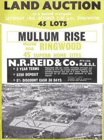
Flyer, Land Auction Advertisement, Mullum Rise, Ringwood - 1970
Double sided leaflet with aerial view of part of Ringwood showing subdivision site, terms of sale, layout of streets and allotments, and summary of local features and services. Additional printout of map with handwritten real estate sales notations includes prices for some allotments.Land auction, Saturday, 10th October (1970). 45 home sites. Subdivision includes Mullum Mullum Road, Hugh Street, Rollington Drive, Cassandra Court, and Jeffrey Drive. Surveyors - R.G. Lee Pty. Ltd., 6 Davis Street, Richmond. Agents - N.R. Reid & Co., 173 Coleman Parade, Glen Waverley, (Telephone) 560 0355 A.H. 560 0361 and Safeway Centre, Boronia Road, Boronia, (Telephone) 762 1022 A.G. 795 2887, also at East Malvern and Mount Waverley. -
 Orbost & District Historical Society
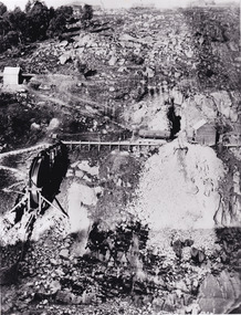
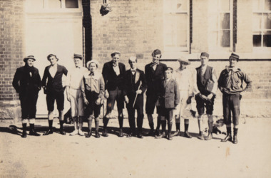
black and white photograph, July 27 1907
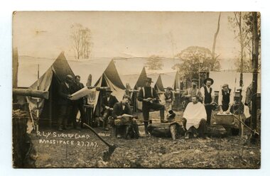
This is a camp of survey workers surveying the railway line . They were camped at Mossiface in 1907. It has been sent as a postcard - "Dear Miss Ross, Just a card, hoping you are well etc, trust you have not forgotten our trip. I forgot to get the name of the street in Hobart of Mr Benjamin or Temple?????? Sufficient. Yours sincerely H.R. Gordon". It has been dated September 30th 1907. There had been men surveying in East Gippsland from the late 19th century. Railway surveyors advocated two lines beyond Bairnsdale – one via Bruthen and the Tambo Valley to Omeo, the other via Swan Reach and Colquhoun to Orbost, then on to Bendoc and the border. With all the argument and feuding between the warring factions, by the end of 1891, the Parliamentary Railways Standing Committee gave up in despair of trying to reach any agreement and abandoned the idea altogether. Finally, with all problems solved, the first sod was turned at Mossiface on 9.1.1912, the government sticking to the original route in the 1890 survey .This is a pictorial record of a surveyors' camp in the early 20th century. The Bairnsdale to Orbost Railway was a significant contributor to the economy of Orbost until it closed.A black / white photograph / postcard of a group of men at a campsite. In the background is a row of tents. on the right side is a clothes line with several sheets hung over it. Two men are studying a map or chart; one man is sitting with a cloth around his shoulders while another is standing behind him cutting his hair; one man is washing cloth in a tin tub; another appears to be stirring a pot; others are sitting reading or just observing.on front - handwritten is " R.L.Y.S. SURVEY CAMP MOSSIFACE 27.7.07" on back is a letter - "Dear Miss Ross.............yours sincerely ????? Gordon"surveying-railway east-gippsland-railway mossiface-survey-camp -
 Warrnambool and District Historical Society Inc.
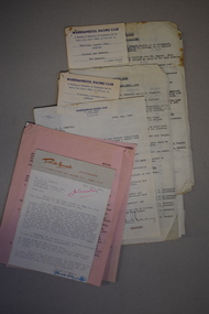
Document, Letters & Minutes, 1960s
These documents contain information about the Warrnambool Racing Club in the 1960s. Race meetings were held in Warrnambool as early as 1848, a few months after the first white settlers arrived. The Warrnambool Racing Club was formed in 1854 and the present day racecourse was first used in 1858. In 1872 the well-known Warrnambool Grand Annual Steeplechase was first held. These documents came from the office of Rolf Crawley, a surveyor, architect and engineer in private practice in Warrnambool and also the engineer for the Shire of Warrnambool from 1935 to 1968. His grandfather, father and uncle were also engineers, working in that capacity or as the Shire Secretary for the Shire of Warrnambool, with the Crawley family recording a total of 132 years of service to the Shire. The Shire of Warrnambool existed from 1863 to 1994. These documents came into the possession of Michael Hand who took over the private surveying practice in Warrnambool of Rolf Crawley. The Warrnambool and District Historical Society acquired these documents, along with several ledgers and other Crawley memorabilia, from the estate of Michael Hand. These documents are of interest as they contain much information on the Warrnambool Racing Club and will be of assistance to researchers.This is a collection of documents relating to the Warrnambool Racing Club. They are typewritten letters and Minutes summaries. Some are copies and there are two cards giving notice of meetings. rolf crawley, warrnambool, warrnambool racing club, shire of warrnambool -
 Bendigo Historical Society Inc.
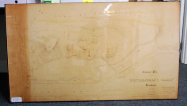
Map - CONTOUR PLAN OF THE GOVERNMENT CAMP SANDHURST 1854, 1994
Contour map (copy) of the Government Camp Sandhurst, 1854. Map is mounted on coreflute and laminated. Written in bottom righthand corner 'Contour Plan of the Government Camp, Sandhurst. Dec 1854. Signed by Richard Larritt, Assistant Surveyor, 11th December 1854.' Shown on map: Pall Mall, Bendigo Creek, Commissioner's Gully, View Place (now View Street), Post Office, Bank of Victoria, District Surgeon, Sandhurst Fire Brigade, Police Hospital, Flagstaff, Gold Office, License Shed, Military Barracks, Stables, Commissioner's Buildings, Police Office. Old Cemetery, Garden. Reference on righthand side: 'Stone or brick buildings are tinted in crimson. Wooden buildings tinted in Indian Ink. Tents and other temporary structures tinted in Burnt Sienna.' Scale of Chains, on bottom of map. Sticker on bottom left hand corner and back of map ' Presented by Survey and Mapping, Victoria, 7th Octber, 1994'.map, bendigo, government camp, pall mall, bendigo creek, commissioner's gully, view place (now view street), post office, bank of victoria, district surgeon, sandhurst fire brigade, police hospital, flagstaff, gold office, license shed, military barracks, stables, commissioner's buildings, police office. old cemetery, garden. , survey and mapping victoria. sandhurst, bendigo. -
 Melbourne Tram Museum
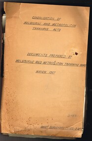
Document - Personal Papers, Melbourne & Metropolitan Tramways Board (MMTB), "Consolidation of Melbourne and Metropolitan Tramway Acts, 1957 - 1958
Brown coloured file folder marked "Consolidation of Melbourne and Metropolitan Tramway Acts - Documents prepared by Melbourne and Metropolitan Tramways Board March 1957" with a sub heading "Chief Surveyors Copies - 2 Sets". Contains may typed and handwritten notes and draft documents in relation to MMTB Act of 1958, including explanatory paper, drafts, annotations, correspondence drafts, files notes, checking documents, correspondence with the Government, MMTB Secretary, revised schedules showing cable trams and how they were closed, track removals etc, tramways authorised by not constructed, existing tramways, descriptions of tramways. Includes drafts of letters to Mr. R. C. Normand, Director of Statutory Consolidation, Parliamentary Draftsman's Office. Would appear Mr. McComb did a lot of work on this project in sorting out the schedules and what the various Act provisions for them were. Includes two MMTB envelopes address to Mr. McComb at the Victoria Parade Offices Fitzroy.trams, tramways, mmtb, acts of parliament, cable trams, tramways, closure -
 Bendigo Military Museum
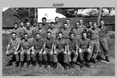
Photograph - A Section, 1st Topographic Survey Troop, Nui Dat, Vietnam, 1969
This is a photograph of A Section, 1st Topographic Survey Troop taken at Nui Dat, Vietnam in 1969. A nominal roll of personnel and their trade as of the 30th of September 1969, accompanies this photo. Their trades in this photo were as follows - Surveyors Topographic: WO1 Darby Munro, SGT Paddy Strunks, SGT Graeme Birrell, CPL Brian Knight, CPL Colin Laybutt, SPR Roderick Gilbert and SPR Rodney Offer. Draughtsmen Topographic: SGT Terrance Linz, CPL Robert Kay, SPR Peter Aukstinaitis, SPR Lloyd Patterson and SPR Ian Wark. Photographer Cartographic: CPL George Graham. Clerk Admin: CPL Oreste Biziak. Helioworker: CPL Geoffrey White, SPR Lance Percey. Cook AACC: PTE R. Johnston. The first Royal Australian Survey Corps troops arrived in South Vietnam on the 10th of June 1966. This was a detachment from 1st Topographic Survey Troop, which was to give cartographic support to the Australian Task Force. Their main tasks were to establish a Theatre Grid, map compilation and map revision. Engineer Survey Support in the camp and to the civil community and give assistance to the Cordon Search Missions by producing large scale plots from aerial photos with every house and fence etc plotted and then reproduce these by silk screening usually, within a 24-hour period. This support concluded with the withdrawal of Australian troops from Vietnam in 1972. For more information on the career of A Section’s OC MAJ Peter Constantine AM, refer to item 6159P or 6092P. He was the CO of the Army Survey Regiment from 1975 to 1976 and CO of the School of Military Survey (SMS) from 1976 to his retirement in January 1982. His memoirs of active duty in Vietnam ‘Surveyor - Printer Behind the Lines’ was published in 2022. 2IC CAPT Frank Thorogood SB St J’s career culminated at the rank of LTCOL as the CO Army Survey Regiment from 1980 to 1981. More information on the A Section, 1st Topographic Survey Troop and the Army Survey Regiment’s supporting role is provided in pages 89 to 94 of Valerie Lovejoy’s book 'Mapmakers of Fortuna – A history of the Army Survey Regiment’ ISBN: 0-646-42120-4.This is a photograph of A Section, 1st Topographic Survey Troop taken at Nui Dat, Vietnam in 1969. The black and white photograph was printed on photographic paper and is part of the Army Survey Regiment’s Collection. The photograph was scanned at 300 dpi. .1) - Photo, black & white, 1969. Back row L to R: SPR Lance Percey, SPR Bruce Grisdale, SPR Rodney Offer, SPR Roderick Gilbert, CPL Geoffrey White, PTE R. Johnston, CPL Colin Laybutt, SPR Lloyd Patterson. Centre row L to R: SPR Peter Aukstinaitis, SPR Ian Hanna, SPR Ian Wark, CPL Robert Kay, CPL George Graham, CPL Oreste Biziak, CPL Brian Knight. Front row L to R: SGT Terrance Linz, SSGT Gordon Haswell, 2IC CAPT Frank Thorogood SB St J, OC MAJ Peter Constantine AM, WO1 Darby Munro, SGT Paddy Strunks, SGT Graeme Birrell.An A4 nominal roll of personnel and their trade accompanies the photo, as of the 30th of September 1969. A torn paper identifies the personnel in the photo. Annotated on back of photo – ‘Unit Photo – 1 Topo Svy Tp 30 Sept 69’royal australian survey corps, rasvy, army survey regiment, army svy regt, fortuna, asr -
 The Beechworth Burke Museum
Photograph, c1900
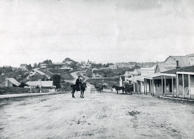
Believed to have been taken sometime between 1858 and 1908, featuring a man with moustache, dressed in hat and long riding coat, seated on a bob-tailed horse, is stopped in the middle of a wide dirt road in Beechworth. He is outside a row of businesses, including R.McKenzie & Sons Grain Store and Mackenzie Family Store (Wholesale & Retail Est. 1855), along a sloping hill. Behind the main rider are a parked horse and laden two-wheeled cart backed up directly outside the grain store's verandah, and another man is driving a horse and four-wheeled wagon forward towards them. At the bottom of the hill is a bridge (Newtown Bridge) with forked road on the far side, leading to a number of houses on both sides of another hill. This image is looking down Bridge Street, Newtown, Beechworth and across to Ford Street (left) and High Street (right). Road-making was a focus of town development during the 1850s, and the wide streets were created on the instructions of the surveyor-general to be between sixty-six and ninety-nine feet wide to give the town a pleasing aspect.This photograph is important in showing the development and expansion of the various businesses and buildings in Bridge Street of Newtown, Beechworth. Black and white rectangular photograph printed on paperReverse: 6980/ PH 118/ 1998.00059/beechworth, new town, newtown, newtown beechworth, local business, mackenzie family store, mackenzie's family store, mackenzie, grain store, bridge, ford steet, high street, colonial australia, australian gold rushes, mining technology, beechworth historic district, indigo gold trail, migration, indigo shire, mckenzie and sons grainstore, mckenzie family store, mckenzie, newtown bridge -
 The Beechworth Burke Museum
Photograph - Photograph - Reproduction, 1890-1900
The photograph appears to depict the of the entrance to the Rocky Mountain Tunnel. The Rocky Mountain Tunnel runs from opening of the tunnel, underneath the Beechworth town, to the Gorge. This tunnel drained the excess water from the upper Spring Creek Goldfield to allow for mining access in the area. The Rocky Mountain Co. blasted through the granite rock to create the original 400ft-long tunnel in 1859, but between 1867 and 1871, the Rocky Mountain Gold Sluicing Co. widened and extended it. At its completion, it measured 14ft deep, 6ft wide, and almost half a mile long. The mining surveyor at Beechworth called it 'without doubt, the greatest undertaking of the kind in the colony'. When the company became the Rocky Mountain Extended Gold Sluicing Co. in the mid-1870s, they continued the tunnelling work. The work was reportedly vital to mining being able to continue at Beechworth and may have established world records in tunnelling through hard rock. The entrance at the Gorge side of the tunnel can be seen from the Beechworth Gorge Walk. The tunnel continues to be an outfall drain for the lake and the town.The search for gold is ingrained into the history of Victoria and therefore, images like this one which portray an open cut sluicing site can reveal important information for society and technology for the date when the photograph was taken. This image is of important historical significance for its ability to convey information about sluicing and the methods used to find gold in the late 1800s and early 1900s. It also shows a location where sluicing was undertook which provides insight into the impact of sluicing on the environment at a time when it was done. The Burke Museum is home to a substantial collection of Australian mining photographs which can be used to gain a deeper understanding into life on the gold fields, technology used in mining, the miners themselves and the impact of the gold digging on the environment.A black and white rectangular reproduced photograph printed on matte photographic paper.7814beechworth, beechworth museum, burke museum, australian museum, mining, rocky mountain mining co., rocky mountain mining company, mine, mining company, rocky mountain mine, mine entrance, rocky mountain, gold, gold mining -
 Melton City Libraries
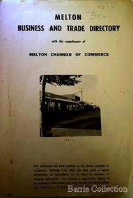
Booklet, Melton Business and Trade Directory, c.1965
BUSINESS TRADE AND DIRECTORY MAP NORTH of High Street RALIEGHS Road - Early settlers Oliver Reierson ( Norwegian) Raliegh SHEBLER Court Auguste EMIL Court Jongebloed Family residence “Hemlich” ALEXANDRA Street Coronation King, Queen Alexandra - 1903 O’NEILS Road Farmer OLDERSHAW Road CORR Grove Early landowner, Teacher at the Common School – Denominational Churches, 1850’s Wesleyan (Methodist) BRYAN Court 1850’s resident renamed from earliest town site - Flat HURLEY Street Early settler and farmers - CHESNEY Road was named Minns, due to duplication altered to Chesney (Minns) SOUTH of High ALKEMADE Drive. Family name ARNOLD Court Family BARRIES Road Charles Ernest Barrie “Darlingsford” 1911 Residence KILPATRICKS Road became Barries Road west of Station Road BLACKWOOD Drive Alexander, Early settler CALLANAN Drive Surveyor early LUBY Court John Luby - Crown Grant Land title KERWIN Street Michael - Crown Grant land title (deleted due to Freeway)Pamphlet of Melton Businesses and map of the townlocal identities, misc., council -
 Melbourne Legacy
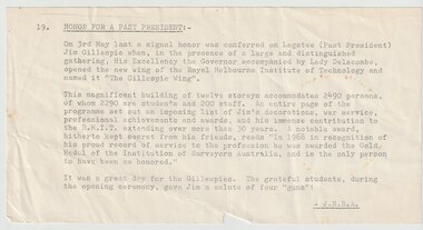
Document - Article, Bulletin. Honour for a Past President (Jim Gillespie)
An article from the Melbourne Legacy Bulletin about Legatee Jim Gillespie being honoured by RMIT naming a building after him. Date is not known but likely to be 1969 or 1970. The article mentions 'an honour was conferred on Legatee (Past President) Jim Gillespie when the Governor and Lady Delacombe opens a new wing of the Royal Melbourne Institute of Technology and called it 'The Gillespie Wing". The magnificent building of 12 stories accommodates 2490 persons (2290 students and 200 staff). A page of the programme was set out to list Jim's decorations, war service, and professional achievements and awards and his immense contribution to the RMIT extending over more than 30 years. Also that in 1968 in recognition of his proud record of service to the profession he was awarded the Gold Medal of the Institution of Surveyors Australia, and is the only person to be so honoured at the time. The article was written by JHBA (Legatee Brian Armstrong). The article was part of an album of past presidents from 1965 to 1989. The folder included biographical details and obituaries, eulogies and death notices of prominent Legatees. The items have been catalogued separately.A record of Legatee Jim Gillespie a past president of Legacy and the recognition he received in his career. The information was collected to record the lives of prominent legatees in a folder.Typed partial page from the Legacy Bulletin on Legatee Jim Gillespie - President 1938past presidents, jim gillespie, rmit -
 Bacchus Marsh & District Historical Society
Map, Atkins and Clarke Land Sale situate at Bacchus Marsh 1856 Copy 2
This plan of land allotments for sale indicates the property once owned by the Bacchus family in and around the township area of Bacchus Marsh. The Bacchus family sold their property in Bacchus Marsh to John Atkins and Robert Nalder Clarke in March 1851. Atkins and Clarke kept the property for a number of years until April 1856 when these allotments were put up for sale.This plan is almost identical to another copy held by the Bacchus Marsh and District Historical Society, VC Record 707, BMDHS collection). This plan, VC Record 452 Copy 2, contains a less detail than than VC Record 707 Copy 1. For example the selling agents and the surveyor who created the plan are not indicated on this copy of the plan. This copy of the plan does indicate the name Crook Street on the map. As the Crook family were the buyers of the Manor House property and surrounding land from Atkins and Clarke in 1856 it suggests that this copy is a later one of the earlier version. It is unlikely that the Crook family would have had the adjacent street named after them prior to purchasing the house and property. This is a very early land sales plan for the township of Bacchus Marsh and it therefore provides some clues as to how the early urban development of the township took place. Upon seeing the map in 1911 Bacchus Marsh Express newspaper editor Christopher Crisp wrote "The sale appears to have created the present township, which had a nucleus in earlier times further east", Express, 30 September, 1911, page 3. A single page paper map showing a portions of land available for sale in Bacchus Marsh in 1856. The subdivided land shown was owned by John Atkins and Robert Nalder Clarke, but previously owned by the Bacchus Family and was in and around their Manor House (Mansion) property in Bacchus Marsh.There are 5 portions of land further divided into numerous small portions. The land for sale is bounded by the present day streets of Main Street, Young Street, McFarland Street, Morton Streets, Crook Street, and part of the eastern section extends to the Lerderderg River. Scale: 4 chains to 1 inch. The map is pasted into a bound volume containing 76 maps or plans in total. High resolution digital image stored on BMDHS computer network. Plan of the first portion of land. The property of Messers Atkins and Clarke situate at Bacchus Marsh.land sales, land sales bacchus marsh, manor house bacchus marsh, crook family bacchus marsh -
 City of Moorabbin Historical Society (Operating the Box Cottage Museum)
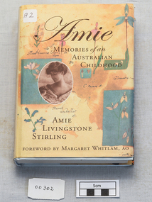
Book, Stirling, Amie Livingstone, Amie, Memories of an Australian Childhood, 1980
... surveyors ...Amie Livingston Stirling 1880-1945 recorded her memories of growing up in Omeo, Elwood and San Remo in Victoria and in 1880s and '90s. About her father James Stirling, the famous coal-mining pioneer and geologist. Her grand-daughter Linda Harrison compiled her writings and added stories from her later life in Paris and North Africa274 p. : ill., ports., tables ; Pale blue hardback book of the childhood memories of Amie Livingston Stirling1880- 1945, compiled by her grand-daughter Linda Harrison in1980 non-fictionAmie Livingston Stirling 1880-1945 recorded her memories of growing up in Omeo, Elwood and San Remo in Victoria and in 1880s and '90s. About her father James Stirling, the famous coal-mining pioneer and geologist. Her grand-daughter Linda Harrison compiled her writings and added stories from her later life in Paris and North Africastirling james, reid elizabeth, early settlers, pioneers, surveyors, geologists, gippsland, omeo, elwood, melbourne, victoria, geelong, mining, botany, von mueller baron, elster creek, brighton, moorabbin, howitt alfred william, murray r a f, goodsir agnes, amie stirling -
 Bendigo Historical Society Inc.
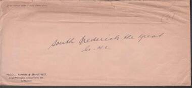
Document - MCCOLL, RANKIN AND STANISTREET COLLECTION: SOUTH FREDERICK THE GREAT CO NL, 1934
McColl Rankin & Stanistreet, South Frederick the Great Co NL. a/ Plan of Residence Areas on No. 10287, by J O Charlton, Parish of Yarraberb. Includes land for school, owners names of blocks, crown land. Signed: Garnet G Birch. Dated 27/4/1935, licensed surveyor. b/ Letter from Department of Mines to McColl Rankin & Stanistreet in reference to letter regarding lease No. 10287. On back of letter are notes relating to blocks of land on lease No.10287. c/ Plan Of Area For On Lease No. 10287 Ben. By John O Charlton. Mining District of Bendigo, Parish of Yarraberb, Lease No. 10287 Ben. By John O Charlton. Mining District of Bendigo. Date 21/6/1934. Signed Garnet G Birch. Blocks include name of purchaser. d/ Plan Of Area For On Lease No. 10287 Ben. By John O Charlton. Mining District of Bendigo, Parish of Yarraberb, County of Bendigo. Dated 21/6/1934. e/ envelope inscribed South Fredrick the Great. 51.organization, business, gold mine, plan of area for on lease no. 10287 ben. by john o charlton. mining district of bendigo, parish of yarraberb, county of bendigo j o charlton garnet g birch department of mines lease no. 10287 ben. by john o charlton mining district of bendigo 1934 -
 Echuca Historical Society
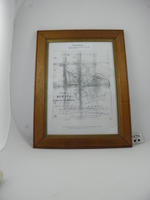
Map, Map of Township - Echuca
Map on white paper that has yellowed. Black print Handwriting is black but faded. In wooden frame behind glass. Printed Survyor's plan for Echuca Township, date 5th March 1855, from the Surveyor General Office. Melbourne March 5th 1855 Plan drawn by P Chauncey. Hand written- This plan is now a Port for the South Australian Steamer Trade - when Hopwood settled here/ it was only a wild bush - he is now throwing a bridge/ at his own cost across this river 200yards wide. signed by Henry Hopwood. Typed on backing paper: Plan of the township of ECHUCA dated March 1855, One month before the first land sales / Autographed by Henry Hopwood in Oct 1955. -
 Eltham District Historical Society Inc
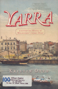
Book, Kristin Otto, Yarra : a diverting history of Melbourne's murky river / Kristin Otto, 2005
"It was John Wedge, Batman's private surveyor, who named the Yarra Yarra. In September 1835 he was at the Turning Basin with some Kulin and heard them identify the river as it came over the Falls as, he wrote, 'Yarrow Yarrow'. It was only some months later that Wedge discovered they had been referring to the pattern and movement of water over the Falls, not the river itself. And ever since, it has been the Yarra's fate to be misunderstood: maligned for its muddiness, ill-used as sewer and tip; scooped, sculpted, straightened and stressed, 'cleaned up' to the detriment of its natural inhabitants; built-over, under and beside; worked mercilessly and then bridged almost to maritime extinction. In Kristin Otto's superbly entertaining new history, the whole sorry tale is laid bare. From the creation stories of Kulin owners and geologist blow-ins (and Robert Hoddle's bad-tempered expedition to the headwaters) to the twenty-first-century waterside building boom, Otto traces the course of Melbourne's murky river. Erudite, affectionate and witty, with more meanders and diversions than the river itself, Yarra is both a fascinating read and a fitting tribute to the 'noble stream'." -- Publisher's website.Paperback; [viii], 245 p. : illus., maps ; 24 cm.ISBN 1920885781yarra river -
 The Beechworth Burke Museum
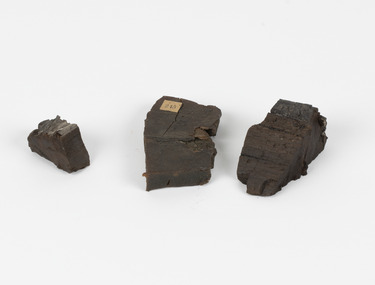
Geological specimen - Coorongite
Coorongite is a dark, rubber-like, highly resilient structureless algal deposit. In the Coorong district of South Australia it occurs in moderate quantities associated with the coastal swamps and sand dunes which extend for a considerable distance east of the mouth of the Murray. This particular specimen was recovered from the south of the Coorong River, South Australia. A type of sediment rich in organic matter, Coorongite is the unlithified end-member of the sapropelic coal series. The members of the sapropelic coal series can be ranked in order as sapropel (the unlithified form), sapropelic-lignite, and sapropelic-coal (the lithified forms) based on increasing carbon content and decreasing volatile content. Sapropel (Coorongite) is an unlithified dark, pulpy, fine organic mud containing concentrations of algae and miospores that are more or less identifiable. Coorongite is typically found as an algae like substance, that can be found in irregular size pieces. Coorongite was believed to be dried up oil due to its rubber-like texture. The Coorongite is also soft to the point where it can be cut into with a knife or it can be broken and torn by hand. Otherwise known as 'Kurangk', the Coorong River is home to the Ngarrindjeri people, which acts as both a place for gathering food and a spiritual place. In 1852 the first sight of Coorongite was found along the Coorong River. The finders mistook the Coorongite for dried up oil, which lead to the belief that there were oil reserves under the Coorong River. Between the 1860s and the 1930s the Coorong River became a place where mining oil and Coorongite became precedent. Nowadays, the local council and the South Australian Government are working together with the Ngarrindjeri people to sustain and preserve the Coorong River and the culture that is with it. Soon after gold was discovered in 1851, Victoria’s Governor La Trobe wrote to the Colonial Office in London, urging ‘the propriety of selecting and appointing as Mineral Surveyor for this Colony a gentleman possessed of the requisite qualifications and acquaintance with geological science and phenomena’. Alfred Selwyn was appointed geological surveyor in Australia in 1852 which began the Geological Survey of Victoria. Selwyn went on to collect geological samples and catalogue thousands of specimens around Australia. In 1853-69 the Geological Survey issued under Selwyn's direction sixty-one geological maps and numerous reports; they were of such high standard that a writer in the Quarterly Journal of the Geological Society of London bracketed the survey with that of the United States of America as the best in the world. During his years spent in Australia, Selwyn collected numerous significant geological specimens, examples of which are held in collections such as the Burke Museum.Coorongite is considered to be a mineral with a unique texture, where it can be both hard and soft. Coorongite can also be considered to be a rare mineral, as it is only located along the Coorong River and due to the mining of it, has left very few sources. It was believed at one point that Coorongite could be used to replace oil. This specimen is part of a larger collection of geological and mineral specimens collected from around Australia (and some parts of the world) and donated to the Burke Museum between 1868-1880. A large percentage of these specimens were collected in Victoria as part of the Geological Survey of Victoria that begun in 1852 (in response to the Gold Rush) to study and map the geology of Victoria. Collecting geological specimens was an important part of mapping and understanding the scientific makeup of the earth. Many of these specimens were sent to research and collecting organisations across Australia, including the Burke Museum, to educate and encourage further study.Three solid varyingly hand-sized pieces of wooden appearing organic matter derived from the river in the Coorong District in South Australia. A rubber-like, highly resilient structureless algal deposit.Specimen 245 page 69 / in Descriptive Register / "Elcestic Bitumen, / Coorangite" South of / Coorung River, South Australia . / C. WIllman / 15/4/21burke museum, beechwoth, indigo shire, beechworth museum, geological, geological specimen, mineraology, coorong, coorong river, kurangk, ngarrindjeri, south australia, coorongite, coorongite specimen -
 Glen Eira Historical Society
Letter - MONUMENTS AND NATIONAL REGISTER
This file contains five items pertaining to plaques, memorials and monuments located in Glen Eira: 1/Three letters (1 page each) pertaining to a statue of Isabelle Webb adorning the Caulfield City Hall. The first letter, typewritten, dated 14/07/80, is addressed from J. Pollet, Honorary Secretary of the Caulfield Historical Society, to Mr. G. Calder, City Manager of Caulfield, and announces that the Society has identified the previously unidentified statue and wishes to provide a plaque for it. The second letter, handwritten, dated 20/09/1980, is addressed from Mr. R. Ballantyne of the Caulfield Historical Society to Calder, and laments that the Caulfield City Council has not responded to the first letter. The third letter, typewritten, dated 24/10/1980, is addressed from G. J. Walker, Deputy Manager-Administrator of the City of Caulfield, to Ballantyne, and notifies the latter of the Council’s acceptance of the Society’s offer to provide a plaque. Also included are the invoice and delivery docket for the plaque. 2/A typewritten letter (1 page), dated 26/06/1985, from Norma Polglase, secretary to mayor Brian Rudzki, inviting Mr. and Mrs. R. Ballantyne to an unveiling ceremony at Hopetoun Gardens. 3/A typewritten letter (1 page), dated 05/10/1986, from John Adams, Convenor of the Memorials Committee of the Royal Historical Society of Victoria, to Miss H. Bullock, thanking the latter for her contributions to the Society’s Memorials Project (which presumably consists of the recording of the location of all memorials located in Victoria), and confirming the acknowledgement of four memorials located in Caulfield. 4/A one page typewritten letter, with handwritten note, dated 07/05/1987, from Chilla Bulbeck, project coordinator of the National Register of the Australian Bicentennial Authority, to Mr. R. Ballantyne, thanking the latter for agreeing to act as a recorder for the Project. Attached are 12 pages extrapolating on the Project and a list (2 copies) of monuments thus far acknowledged, although none of this contains anything of relevance specifically to Glen Eira. 5/A typewritten letter, dated 29/11/1996, from Bob Ross, Senior Surveyor of the Geodetic Survey of the Office of the Surveyor General, to the Caulfield Historical Society, requesting the latter’s assistance in identifying any historic survey marks located within Glen Eira, as part of a greater project to identify all such survey marks located within Victoria. Also included is a leaflet extrapolating on the project and featuring a form for documenting survey marks, although this contains nothing of relevance specifically to Glen Eira.glen eira, caulfield, plaques, monuments and memorials, walker g. j., ballantyne r. mr., caulfield historical society, statues, webb isabelle, webb isabella, calder g, pollet j, city of caulfield, caulfield city council, city hall, hawthorn road, glen eira road, neville street, glenhuntly, thompson p. mr., arrow engraving & foundry co., rudzki brian j. p. cr., ballantyne mrs., cannons, festivals and celebrations, invitations, hopetoun gardens, mayors, glenhuntly road, glen huntly road, caulfield city hall, polglase norma, adams john, bullock h. miss, royal historical society of victoria, memorials committee, memorials project, ‘kadimah’, caulfield grammar school, rosstown railway, bambra park, elsternwick, begonia street, gardenvale, bulbeck chilla, australian bicentennial authority, national register of unusual monuments project, jowett memorial drinking fountain, ross bob, office of surveyor general, geodetic survey office of surveyor general -
Ringwood and District Historical Society
Name List, A suggested list of names suitable for streets in Ringwood, and showing origin of name - compiled 1970, c.1970
A suggested list of names suitable for streets in Ringwood, and showing origin of name. Two pages foolscap, 100 names approx. ; Hull: Surveyed Gippsland Road now Maroondah Highway, 1855 (Also name of roar in Croydon); Darke, Wm Wedge, Surveyed all land between Yarra and Western Port, including Ringwood - 1843; Wedge, Chas. Nephew of John Helder Wedge, Batman's surveyor, 1834. Active in Ringwood East Progress Association over 40 years ago.; "Barker's Track" - forerunner of Gippsland Road, Maroondah Highway.; Bickford, N Superintendent of Hodgkinson's Field Party of Surveyors etc. Original Land Owners; Isaacs,S. G. Bought first land in Ringwood - March 1858 - Lot 3; Moss, M.Lot 1 - April 1858; Davis, J. Lot 6 - April 1858; Riley, P. Lot 11 - April 1858; Marks, M.Lot 15 - November 1858; Wieland, C.F. Lot 14b - July 1872; Richter, K.H. Lot 14a - April 1869; Molloy, J. Lot 21 - December 1877; Watson, B. Lot 22a - April 1869; Stutt, W. Lot 27 - June 1884; Blood, R & W.Lot 42-3 - March 1872; Cox, J. Lot 41 - March 1870; Moncrieff, T.Lot 40a - September 1876; Pett, J. Lot 40b - January 1878; Feltham, F. Lot 28a - September 1881; Downing, J.J.Lot 32b - October 1881; Burge, W. Lot 39 - April 1875; Axford, W. Lot 32a - December 1877; Ball, E.A.Lot 37 - March 1869; Parker, G. Lot 28 - June 1882; Gangell, W.Lot 24a - January 1883; Hodgson, A.D. Lot 25a - May 1875; Muldowney, P. Lot 30d - June, 1877; Hosie, J.S. Lot 34, 30b - June 1878; Rourke, H.Lot 36 - July 1869; Duggan, T.Lot 35 - May 1870; Pach, W. Lot 30e - May 1884; Morris, J. Lot 25b - June 1882; Kleinert, A. Lot 29c - August 1886 +Additional Keywords: Hull / Darke, Wm Wedge / Wedge, Chas / Wedge, John Helder / Bickford, N -
Glen Eira Historical Society
Document - Cavers Carre
... Surveyors ...Three articles about Cavers Carre. Handwritten document giving details of the location of the house. Built c.1866 and demolished prior to 1905 when the block was subdivided. No details of the house. Two plans of Gardenvale and Riddell Estate dated 29/11/1884 and unknown from State Library Victoria records.gardenvale estate, glen huntly road, riddell estate, melbourne and brighton railway, mcmillan street, orrong road, archibald street, rowan street, hamilton street, downshire road, shoobra road, madden walter, tuxen august, fraser and co., surveyors, muntz and muntz, cavers carre, elsternwick, stanley street, carre street, railway cresent, riddell parade, riddell john carre, land subdivisions -
 The Beechworth Burke Museum
Photograph, c1924
Taken in 1924, depicted are eleven young men dressed in school uniform attire standing in the playground of Beechworth State School. This group of young men were part of a farcical play titled "School Days" as part of Beechworth State School Concert series. Beechworth Primary School (formally known as Beechworth State School) was constructed in 1875 by architect Henry Bastow (1839 - 1920). Bastow was the chief architect and surveyor for the Victorian Government’s Department of Education. During his chiefship, over six-hundred schools were constructed across the state which was in response to the Victoria’s Education Act of 1872 legislating free, compulsory, and secular education. Performances such as this “School Days” play were common forms of entertainment within Beechworth up into the early twentieth century. This stems from the goldrush period in Beechworth (1852-1866) when travelling entertainers would tour the goldfields offering performances in singing, acting and circus tricks. These were usually held in a local pub or designated concert spaces, such as the Star Theatre in Beechworth. Entertainment offerings begun to slow down mid-twentieth century when the population begun to dwindle. Many locals took up this responsibility and put on their own plays and shows across the town. This photograph is historically significant as it provides insight into the types of entertainment activities held at the Beechworth School during the early twentieth century. It also demonstrates how students engaged with their school outside of their regular schoolwork. Black and white rectangular photograph printed on matte photographic paper mounted on board. Obverse: W.Howes / Beechworth Concert Party 1924 / State School / Beechworth Cyril Smith (Squidgy) / Keith Prowse / Bill Howes / J. Warde / J. Heatherly (Jumbo) / Gea Foster / B. Shallard (Shinky) / A. Foster / Ernie Smith / Jerry Burns / Ted Warden / School Master / Geo Foster in a Farscial Play “School Days” / Reverse: A03065 / 1997.2520 / 79.19.1 / school uniform, beechworth school, school days", concert series., henry bastow, beechworth primary school, victorian government’s department of education, education, victoria’s education act of 1872, beechworth state school -
 Sunshine and District Historical Society Incorporated
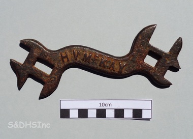
D324 WRENCH - H. V. McKay, H. V. McKay Pty. Ltd, Early 1900's
This type of wrench or spanner was used as a service tool for H. V. McKay Pty. Ltd. manufactured agricultural machinery. This specific tool belonged to Albert (Bert) Montgomery of 11 Kamarooka St, Albion. Bert Montgomery was born in Sunshine and in 1910 was apprenticed as a carpenter with Sunshine Harvester Works, where he worked as a wood machinist. On 19 August 1914, while still an apprentice, he enlisted in the First AIF. He left McKay's and started business as a builder probably just prior to WW2. After the war he joined the Shire of Braybrook as Assistant Building Surveyor until he retired. In 1962 Bert and his friend Jack Causon (proprietor of an Anderson Road second hand store that previously was Les James grocery) were on a fishing trip to Lake Tooliorook (aka Ettrick) near Lismore, Victoria. Their boat capsized and both fishermen were drowned. Bert was a Past President of Sunshine RSL and at that time it was reported that his funeral was the largest that Sunshine had seen. The information about Bert Montgomery was supplied by a Committee member of the Sunshine & District Historical Society Inc. who spoke to Montgomery's daughter, who also donated the tool. This tool serves as a reminder of the large H. V. McKay agricultural manufacturing works that once existed in Sunshine. The tool is associated with the works, and the design is significant enough for images of the tool to be used in an artistic mural, which is painted on the Eastern Pillar of the new H. V. McKay Footbridge in Sunshine, Victoria 3020.Curved double ended rusty cast iron wrench with 4 open slots plus 2 closed slots'H V McKAY' on one side and 'D324' on the reverse sideh. v. mckay pty. ltd, d324, d324 wrench, d324 spanner, agricultural spanner, antique wrench, agricultural tool, albert montgomery, jack causon, lake tooliorook -
 Falls Creek Historical Society
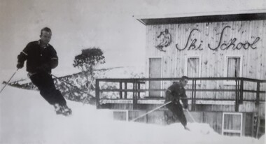
Photograph - Bernhardt Plohberger and Felix Soratroi near Falls Creek Ski School
Bernard Plohberger was one of the early ski instructors at Falls Creek. He was born in Austria on 14 January 1930. He was a ski instructor before he left Austria in 1955. He spent the winter of 1956 working as a ski instructor and during the summer Bernie worked as a chainman for the SEC Surveyor. He built the Ski School at Falls Creek in 1957 as well as the Frying Pan Inn. In 1960 the Frying Pan Inn was taken over by Bill Bridgford who had helped to finance its construction. Bernie married his wife Trudi in 1958 and their son Gerhard was born at the ski school in 1959, the first child born at Falls Creek. Both Trudi and Bernie worked for Bob Hymans for a period at Grand Coeur Chalet. After leaving Falls Creek, Bernie and Trudi moved to Canberra where Bernie took work on civil engineering projects such as the coal loader in Wollongong, the Vietnam memorial in Canberra, highway work on the Hume and Sugarloaf Dam in Victoria. Bernie Plohberger died on 18 May 2020. Felix Soratroi was also an Austrian Ski Instructor who was encouraged by Bernie to move to Falls Creek and work at the Ski School.This item is significant because it depicts early Ski Instructors at Falls Creek Ski School.A black and white image of two skiers near the Falls Creek Ski School.bernard plohberger, frying pan inn, falls creek ski school, felix soratroi -
 Mt Dandenong & District Historical Society Inc.
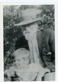
Photograph, Edward Joseph Price and Grandson
John Lundy-Clarke grew up in the Kalorama/Mt Dandenong area and later in life (1972-74) began to write a comprehensive history of the district working from an original settlement map in an effort to cover all areas. Edward Joseph Price took out Lot 1, Section 1 of the Village Settlement and became the first settler, moving his family up into a slab hut on his selection in 1896. Edward Joseph had two sons (Charles Joseph and Edward John) and a daughter (Kathleen Nathalie Caroline). Edward Joseph Price is holding his grandson Teddie, son of Edward John Price. Photo taken 1936.Black and white photograph in close up showing an old man with a white beard wearing a brimmed hat holding a male toddler under the arms. Reverse of photograph has handwritten description by John Lundy-Clarke.Edward Joseph Price and his grandson Teddie son of Edward John. E. Joseph was the first settler in the Village Settlement choosing LOT 1, part of which is still family property (1974). He worked for the surveyors who were marking out the blocks, and disregarded their advice as to which had the best soil, and so doing he obtained the best commercially. He died in 1943 leaving two sons & daughter. Edward John born 1899 died 1974. Charles born 1892 died 1958. Kathleen born 1895 died 1954. Wife Annie nee Ross died 1932.edward joseph price, edward john price, teddie price -
 Orbost & District Historical Society
black and white photograph, C1900
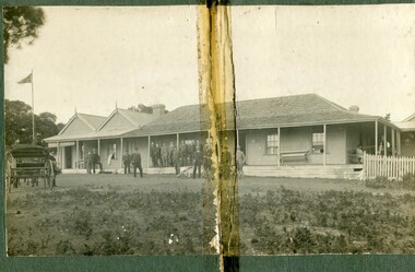
The first settler to occupy the Marlo township area was James Stirling around the year 1875. He built a bark hut on the bluff that had two rooms, bark walls, earthen floors and a shingle roof. By 1884, this structure had expanded to a 9 roomed accommodation house and in 1886 became the Marlo Hotel when a liquor license was granted. The Governor-in-Council declared Marlo to be a township on 18 February 1889. During May 1889, the government surveyor, E.L. Bruce set out 19 sections of the new township, with the first sales of subdivided land occurring the following May. At this time, Stirling's Marlo Hotel was the unofficial hub for the community. It was a general store, accommodation house and the unofficial post office, with settlers taking turns in bringing the mail from Orbost or Cunningham. This continued until Aug 1942, and in 1969 was located in a house adjacent to the Marlo Hotel, before being transferred to the Marlo General Store in this year. The official Post Office List states the Marlo Post Office opened around 1902. in 1925, the "Marlo House" (a nine room accommodation guest house) was granted a liquor licence. The "Marlo House" became "The Marlo Hotel". The Marlo Hotel was popular with many Orbost and district settlers, who travelled to Marlo by horseback or buggy. The Marlo Hotel, perched on the hill overlooking the estuaries and the entrance is a significat building in Marlo. Established in 1886, it has been operating for over 120 yearsA black / white photograph of the Marlo Hotel. Patrons are standing on the verandah and lawns. A horse-drawn carriage is on the left. The photograph is on a green buff card with a rough edge on R H side.on back - " Old Marlo Hotel"marlo-house marlo-hotel stirling-james -
 Orbost & District Historical Society
black and white photograph, C 1900
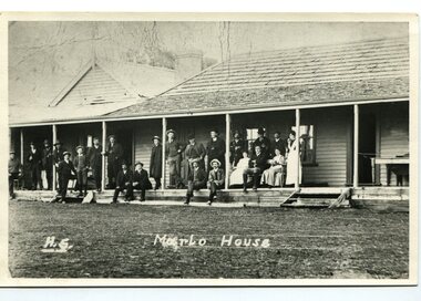
The first settler to occupy the Marlo township area was James Stirling around the year 1875. He built a bark hut on the bluff that had two rooms, bark walls, earthen floors and a shingle roof. By 1884, this structure had expanded to a 9 roomed accommodation house and in 1886 became the Marlo Hotel when a liquor license was granted. The Governor-in-Council declared Marlo to be a township on 18 February 1889] During May 1889, the government surveyor, E.L. Bruce set out 19 sections of the new township, with the first sales of subdivided land occurring the following May. At this time, Stirling's Marlo Hotel was the unofficial hub for the community. It was a general store, accommodation house and the unofficial post office, with settlers taking turns in bringing the mail from Orbost or Cunningham. This continued until Aug 1942, and in 1969 was located in a house adjacent to the Marlo Hotel, before being transferred to the Marlo General Store in this year. The official Post Office List states the Marlo Post Office opened around 1902. in 1925, the "Marlo House" (a nine room accommodation guest house) was granted a liquor licence. The "Marlo House" became "The Marlo Hotel". The Marlo Hotel was popular with many Orbost and district settlers, who travelled to Marlo by horseback Perched on the hill overlooking the estuaries and the entrance, the Marlo Hotel is a significant building in Marlo. It was established in 1886 and has been operating for over 120 years,A black / white photograph of Marlo House with staff and patrons standing and sitting on the verandah.on front - "H.S. Marlo House"marlo-house marlo-hotel -
 Bendigo Historical Society Inc.
Document - NORMAN OLIVER COLLECTION: MAYOR SPEAKS, UNDATED
The Norman Oliver collection. Norman Oliver was three times Mayor of Bendigo - 1950-51, 1964-65, 1970-71. Three typed pages of speech notes. Undated but information suggests 1965. Corrections made in blue and red ink. Mentions that the Easter Fair has recently ended. Topics discussed : the Cancer Campaign success and recent advances in treatment and facilities, a discussion with a Mr Larritt, the grandson of Bendigo's first surveyor, and the work his grandfather performed, especially regarding the reservations chosen for the Hospital and the Home and Hospital for the Aged, the Art Gallery's Dobell exhibition, Commonwealth Youth Sunday on May 2nd, the promotion of Bendigo by the Victorian Promotion Committee, and Anzac Day business. Oliver states that 'in 1914 the citizens of Bendigo presented the 7th Bn AIF with a set of bugles. One of the bugles used by 'Pompey' Simpson in the landing of Gallipoli and in France until he was wounded in 1917, when it was used by Wally Granland until the Armistice. On Anzac Eve at the 9PM ritual to the Fallen, the bugle will be used for the first time since the first war ..by Bugler John Murphy of Southern Command.' The HMAS Bendigo Assoc. reunion and information.bendigo, council, speech notes, norman joseph oliver , councillor norman oliver. mayor of bendigo. anti-cancer appeal. victorian inland meat authority. anzac day. -
 Surrey Hills Historical Society Collection
Photograph, Harley Tarrant and his 1905 Tarrant car, 1905
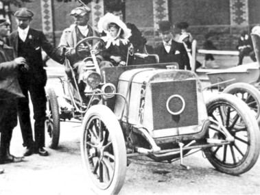
Col. Harley Tarrant was an astute businessman and a part-time soldier. He was born at Clunes in 1860 and as a young man worked with an engineering firm in Sydney. He later joined the Board of Works in Melbourne. and later entered the early car manufacturing and retailing trade. In 1905 Harley Tarrant built the first car to be built and sold in Australia. For a time he was a surveyor and worked in Surrey Hills but motoring became his prime interest. In the early 1890s he set up a workshop in what was then Post Office Place, Melbourne. He built stationary engines which ran on kerosene and in the first years of the twentieth century, with partner W Howard Lewis, built the first petrol driven car in Australia. This photo is of his sixth car and was taken after the finish of the 1st Sydney to Melbourne Dunlop Reliability Trial, which Tarrant won. Harley Tarrant produced cars between 1901 and 1907 at the Tarrant Motor and Engineering Company in Queen's Bridge Street, South Melbourne. The first car had a rear-mounted two-horse power Benz engine. Two-cylinder models were later produced followed by 4-cylinder models. The only Tarrant car in existence in 1984 was owned by Harley Tarrant's grandsons, Kenneth and Peter Holmes of Melbourne. The 1906 Tarrant car featured on an Australia Post stamp in 1984. It was one of a series of 5 stamps featuring Australian veteran and vintage cars.Black and white photo of a car without a hood in the driver's seat of which is a man with cap, driving dust coat and goggles, identified as Harley Tarrant. Beside him is a young girl in a large frilly; she is identified as Doreen Tarrant, his daughter. Another man with cap and goggles is talking to him and a gentleman in a bowler hat looks on. There is a women and 2 children in the background in front of a large brick wall decorated in two coloured bricks. cars, inventions, dunlop reliability trial, tarrant motor and engineering company, mr harley tarrant, miss doreen tarrant, mrs doreen holmes, col harley tarrant -
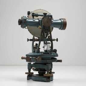 City of Greater Bendigo - Civic Collection
Instrument - Theodolite, Cooke, Troughton & Simms, c 1940
Theodolites are a highly accurate instrument that measures angles between designated visible points in the horizontal and vertical planes. The theodolite has a long history, with the term first found in 1571 in a surveying textbook 'A geometric practice named Pantometria' by Leonard Digges. (source https://en.wikipedia.org/wiki/Theodolite). Cooke Troughton & Simms began when John Troughton starting selling products in Fleet Street, London in 1782. He went into partnership with his brother Edward in 1807 who expanded the business considerably. William Simms, a former apprentice with the company was taken as a partner and then manager after Edward died in 1835 and the company became Troughton & Simms. By 1887 the company was able to produce all the parts necessary for their instruments and the company employed nearly 200 people and was one of the most well respected firms of instrument makers of the 1800's. James Simms, son of William who had inherited the company died in 1915 and the company was turned into a limited liability company by his two sons William and James. Things however were not so easy for the two sons and in 1922 the business was brought out by their rival T. Cooke & Sons becoming Cooke, Troughton & Simms. Theodolites are used by surveyors as part of their everyday work and although there is no specific information regarding the provenance of this particular one it is assumed it was used locally by the City of Bendigo and / or the Lands Department.A grey theodolite no 39161 made by Cooke, Thoughton & Simms. Various moving parts showing signs of extensive use particularly on the uprights on the main body and around knobs and dials where the paint is worn back to brass.Cooke, Thoughton & Simms Ltd / York. England / No 39161. Sticker; DPS - Asset No / (barcode) / 0010173city of greater bendigo administration item, lands and survey department bendigo