Showing 11713 items
matching railways
-
 Maffra Sugarbeet Museum
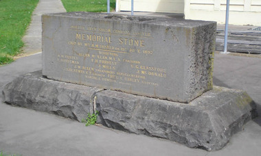
Foundation Stone
Foundation Stone from the Maffra Sugar Beet Factory, mounted on two blocks of stone that originated from the footings of the Bushy Park railway bridge. It reads: Maffra Sugar Beet Company Limited / Memorial Stone /Laid by Mrs A.M. Foster on 19 June 1897 / Directors / Allan McLean MLA Chairman / A.M. Foster F.H. Forrest C.G. Glassford / F. Horstman J.Mills J.McDonald / J.W. Allen Treasuer's Representative / J.Salatnay C.E. Engineer Fred C. Barley Secretary / Waring & Rowden Builders.sugarbeet -
 Southern Sherbrooke Historical Society Inc.
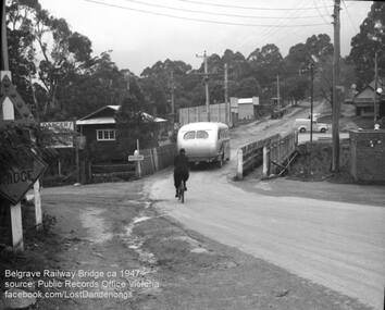
Photograph, Belgrave Railway Bridge, 1947
Belgrave railway bridge looking towards Bayview Road from Terrys Ave, 1947. It shows a bus crossing the bridge onto (now) Belgrave-Gembrook Road, followed by a male cyclist wearing a dark overcoat and bowler hat. A man wearing a homburg hat is crossing the footbridge beside the main bridge towards the main street. There is a pale van parked (or driving past) a dairy on the corner of Bayview Rd and Belgrave-Gembrook Road. A brick toilet block is shown with a sign saying 'MEN' on a nearby lamp post. -
 Ballarat Tramway Museum
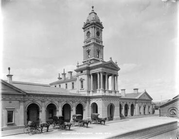
Photograph - Digital image, Fred Hardie, Ballarat Railway Station GB 0231 MS 3792/A2069, 1892
Yields information about the appearance of the Ballarat Railway Station c1892Digital image from the George Washington Wilson and Co. photographic collection held by the University of Aberdeen - see related documents for information and their website for reproduction permissions. It notes that Fred Hardie was sent to Australia in 1892. There are some 41 Ballarat images available on the website. Ballarat Railway Station GB 0231 MS 3792/A2069. Has a number of horse cabs in front of the station. See: https://www.abdn.ac.uk/special-collections/about-george-washington-wilson-383.php - accessed 29-12-2017.trams, tramways, railway station, horse cabs, ballarat -
 Ballarat Tramway Museum
Photograph - Digital image, W. J. Llewelyn, c1954
Set of two colour digital images taken by W. J. Llewelyn of the Johns Valves Ballarat factory on the south side of Norman St Ballarat under construction c1954. .1 - looking from the SEC Power Station B towards Wendouree - note the narrow Norman St. .2 - looking back towards the City of Ballarat, with the Railway Workshops and the Showgrounds in the distance. See https://bih.federation.edu.au/index.php/M._B._John_Ltd. accessed 12-6-2017 Photo taken at the same time as btm6855i.trams, tramways, secv, manufacturing, norman st, creswick road, industry -
 Ballarat Tramway Museum
Newspaper, The Courier Ballarat, "Meeting to push for tram's return", 22/01/1996 12:00:00 AM
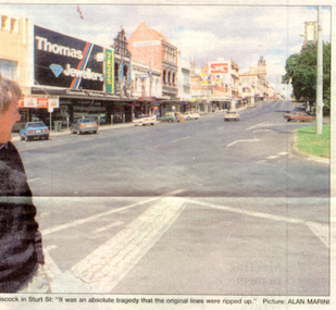
Article from page 1 and 2 of The Courier, Monday 22/1/1996 written by Andrew McBride that a meeting is to be held the following day at the Ballarat Town Hall to form a group to push for the return of trams to Ballarat. Quotes Peter Hiscock, Sovereign Hill Executive Director and Andrew McEvoy, Ballarat Tourism Board, Executive Officer. Also has item about the $2m upgrade of Ballarat Railway Station. Includes a photo of Peter Hiscock looking along Sturt St. from Grenville St. Photo by Alan Marini."Franklins Fresh 329" stamp in top right hand corner in black ink.trams, tramways, public meeting, ballarat railway station, ballarat city tramway, ballarat revival -
 Ballarat Tramway Museum
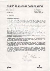
Document - Letter/s, Public Transport Corporation (PTC), 25/06/1992 12:00:00 AM
Copy of printed or photocopied letter sent to all Public Transport Corporation (V/Line - railway and The Met - Tramways and bus) dated 25/6/1992 signed by the Chief Executive Office, Ian F.X. Stoney. Letter concerns the "alleged" drinking of tramway staff and illegal stoppage of trams, as published in the Sunday Age. Investigations determined the photo was the Coburg Tram terminus and the crew member was drinking a "Bundaberg Ginger Beer" stubbie. Letter written in support of staff and to criticize the AGE newspaper who refused to supply a negative.trams, tramways, ptc, i. stoney, sunday age, tram crews -
 Ballarat Tramway Museum
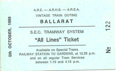
Ephemera - Ticket, Vintage Train - ARE - ARHS - AREA, Combined tour ticket Ballarat, Sep. 1969
Special "All Lines" ticket on aqua green index board or card for an ARE - ARHS - AREA Vintage Train Outing to Ballarat for 5/10/1969, numbered "No. 122". Notes as available on Special Trams Railway Station to Gardens at 12.25 pm and on all regular Tram Services between 1.15 and 4.15pm. See Reg. Item 3037 for photos of this event - ? (not 100% certain of this statement - WAD 18/2/05) Three further copies of the ticket added 1/11/2005 - Nos. 143, 146 and 147.trams, tramways, tickets, all lines tickets, vintage train, are, area, arhs -
 Ballarat Tramway Museum
Newspaper, "Melbourne's First Tramcars", 11/03/1962 12:00:00 AM
Newspaper clipping contained within Reg. Item 2526, page 10, titled "Melbourne's First Tramcars" - noting that the Argus of 11/3/1962 reported that two of Mr. George Francis Train's patent tramcars had been landed in Melbourne with fittings for four more. Item said that promoters were negotiating with the City Council, but these fell through, as Council did not have the power to lease the streets for railway purposes. Has been cut out from a sheet and pasted into the book. Note Item Not formally Numbered.melbourne, tramcars, tramways -
 Ballarat Tramway Museum
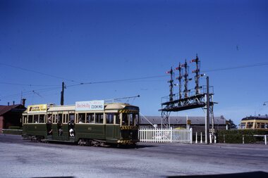
Slide - 35mm slide/s, Eldon Hogan, early 1960's
35mm Kodachrome cardboard mount slide of Ballarat No. 40 southbound in Lydiard St North, crossing the railway level crossing. In the background is Kennedy Murray General Carters building, the main signal gantry and a Walker Rail car - 280HP?. No. 40 has roof advertisements for Eureka Roofing Tiles and "Electricity Best for Cooking". Photo taken early 1960's. Photo from the Eldon Hogan collection. See email with worksheet from R.Gilbert date 29/12/2000 and Fares Please!, May 1995. In ink on the top of the slide "Bogie car at Ballarat Station"tramways, trams, railway station, lydiard st north, signals, tram 40 -
 Ballarat Tramway Museum
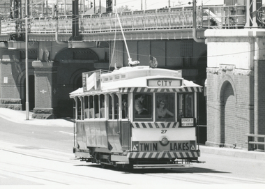
Photograph - Black & White Photograph/s, John Phillips, 26/01/1981 12:00:00 AM
Yields information about one of the two visits to Melbourne for the Australia Day Parade of one of the Museum's trams.Black and White photograph of BTM No.27 operating in Flinders St. near intersection with William St. Melbourne during Australia Day 1981 - 26/1/1981 - see March 1981 issue of Fares Please!. Carolyn Dean driver. Photo John Phillips. Tram has destination of "CITY" and an auxiliary board "Spencer St Rly Station" and Twin Lakes sign. In the background is the Flinders St. railway bridge. Two copies held. See Reg Item 7402 for another photo of the tram in Flinders St. tramways, trams, btps, flinders st, australia day, tram 27 -
 Ballarat Tramway Museum
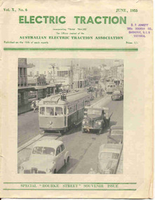
Magazine, Australian Electric Traction Association (AETA), "Electric Traction", Jun. 1955
Yields information about the construction method of High St Northcote Melbourne, Bourke St and the construction of the new trams at the time for Melbourne.June 1955 issue of Electric Traction, Vol X No. 6 - featuring Melbourne No.996 in High St Northcote, during the construction of the tramway with two trams being ferried to the new Preston depot. See detail caption. Only one line shown, the second is under construction in the rear. Features articles on the construction of the Bourke St routes, construction of new W7 (known then as SW6c), tramcars, possible new routes in Melbourne, news from Pittsburgh, Victorian Railways, Bourke St. roll, AETA notes.Stamp of "D.F. Jowett etc" in top left hand corner.trams, tramways, melbourne, bourke st, tramcar construction -
 Ballarat Tramway Museum
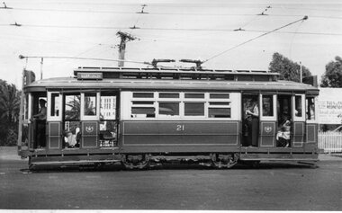
Photograph - Black & White Photograph/s, 1954
Yields information about the appearance of Geelong 21 and the crews operating it on a hot summers day.Black and white photograph of Geelong No. 21, side on view, inbound to the city area with the destination of Belmont. Shows the crews in shirt sleeves, the blinds drawn and the length of the tram with its two trolley poles. Photo by an unknown photographer, 1954. Dave O'Neil confirmed June 30/2009, the tram is travelling from North to Belmont, lost likely at Mercer and Railway Terrace. Entrance to the goods yard is at the rear of the tram, and Gordon institute can been seen through the front entrance. See Related documents.In pencil on the rear 1954.tramways, trams, geelong, crews, railway station, tram 21 -
 Ballarat Tramway Museum
Slide - 35mm slide/s, Max Michell, Dec. 1968
White cardboard mount, 35mm slide, from the Association of Railway Enthusiast's film strip titled "Provincial Tramway Film Strip" of Bendigo 30, just after departure from North Bendigo terminus in Thunder St. Photo taken after the tram has passed the photographer. The film strip notes (Reg. Item 2560), provided the following caption details: "Birney No. 30 departs the terminus at "NORTH BENDIGO" - Dec '68 (Max Michell)" See image btm2591p.tif for high level scan of image. Stamped on base of slide "11801" and written in ink on top edge "No 30 Nth Bendigo"tramways, trams, are, film strip, north bendigo, thunder st, tram 30 -
 Ballarat Tramway Museum
Slide - 35mm slide/s, Harry Jackson, Dec. 1971
White cardboard mount, 35mm slide, from the Association of Railway Enthusiast's film strip titled "Provincial Tramway Film Strip" of a Bendigo No. 3 standing at the Eaglehawk terminus with the Town Hall in the background. Tram reflected in shop windows and shows some of the verandas of High St. Eaglehawk. The film strip notes (Reg. Item 2560), provided the following caption details: "Bogie car No. 3 stands at "EAGLEHAWK" in the hot midday sun. = Dec. '71 (Harry Jackson) See image btm2597p.tif for high level scan of image. Stamped on base of slide "11807" and written in ink on top edge "No. 3 Eaglehawk"tramways, trams, are, film strip, high st, eaglehawk, tram 3 -
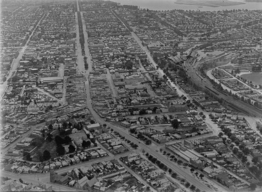 Ballarat Tramway Museum
Photograph - Digital image, c1925
Yields information about Ballarat c1925 from an aerial photograph looking west.Digital photograph of Ballarat looking West c1925, aerial view, looking along Sturt St and Bridge St, taken from about Eureka and Kings St. Shows both the Alfred Hall, the Railway Station, Sunshine Biscuits and the Coliseum. Shows two single truckers at the east end of Sturt St and two at the west end of Bridge St or Grenville St. See email from Alan Bradley dated 28/7/2012 re date. See also Reg Item 5453 for another similar photograph.trams, tramways, ballarat, aerial views -
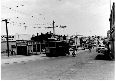 Ballarat Tramway Museum
Photograph - Black & White, Bendigo 3 climbing Mitchell St, late 1950's
Black and White photograph, of Bendigo 3 climbing Mitchell St, near the Railway Station with the Destination of Quarry Hill. Has a Hutton's Ham ad on the front drivers panel and two rood ads. In the background are Sandhurst Dairies shop advertising Toppa Ice Cream, a boot repairer and a van marked Jeffreys Bread parked on the north side of Mitchell St. Nearing the point where the double track became single - see the signal wire insulators in the overhead. Printed on Fujichrome paper. Two copies held."TMSV Sales" stamp on rear. On rear of in ink 'HTT16 = MM N 102 = Geel 32 = BED 3"trams, tramways, bendigo, mitchell st, quarry hill, overhead, tram 3 -
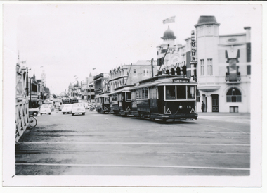 Ballarat Tramway Museum
Photograph - Digital image, Wal Jack, 2/03/1958 12:00:00 AM
Yields information about the arrangements made to transport trams from Melbourne to Ballarat by Yellow express vehicle.Digital image from the Wal Jack Ballarat Album of a photograph of Queens Mothers visit in 1958. Sunday 2/3/1958, outside the Railway Station in Lydiard St North. Sunday 11AM. Trams waiting special trains. No. 14, 13, 28, 40 34 up line, 26, 39, 27 down line. See image i2 for rear of photograph. See image i3 for hi res scan of print. See image i4 for hi res scan of negative Two negatives held.Royal visit day - SEC 2/3/58, Ballarat, Lydiard St North, Sunday 11AM. Trams waiting special trains. No. 14, 13, 28, 40 34 up line, 26, 39, 27 down line. In top right hand corner is Wal Jack stamp with number T245 written in.trams, tramways, royal visit, lydiard st north, railway station, tram 14 -
 Bendigo Historical Society Inc.
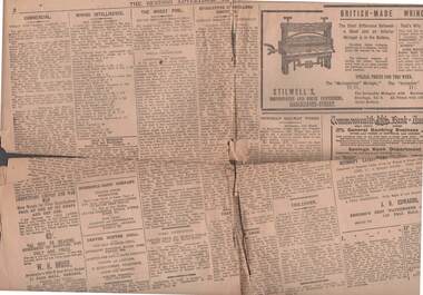
Newspaper - THE BENDIGO ADVERTISER 16/3/1916
The Bendigo Advertiser, dated Thursday, March 16. 1916. Pages 1 to 4. Some items are: Bendigo Pottery Works, Life on a Troopship - Wheeler Harold Abbott's Notes, Hearing conducted in Melbourne on 15th March re Dr. H. L. Atkinson's Will, A Sick Soldier, Private R. J. Arnold, 6th Batt., of Bendigo with photo, Mining Intelligence, Licenses Reduction Board, naming hotels in the Bendigo, Kangaroo Flat and Strathfieldsaye Licensing Districts, the Eucalyptus Distillers' Dispute and Victorian Railway Works.newspaper, bendigo advertiser, news items, the bendigo advertiser 16/3/1916, bendigo pottery works, wheeler harold abbott, dr h l atkinson, pte r j arnold 6th batt, licenses reduction board, mining intelligence, eucalyptus distillers dispute -
 Bayside Gallery - Bayside City Council Art & Heritage Collection
Map, Department of Crown Lands and Survey, Melbourne and Suburbs, City of Sandringham, 1917-1926
map, plan, foreshores, sndringham, hampton, beaumaris, cheltenham, department of lands and survey, cartographic material, borough of sandringham, moorabbin, black rock, street map, city of sandringham -
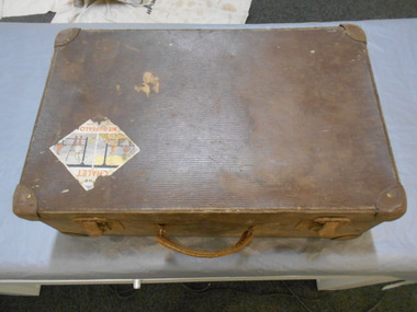 Bendigo Historical Society Inc.
Functional object - Suitcase Made in Bendigo
G. Harper was a saddler and harness maker located at Bath Corner, Charring Cross. He advertised in The Bendigo Advertiser in 1892A brown suitcase with two metal clasps which could be locked. There are two travel stickers, ones a Victorian railways luggage Melbourne Albury which is partly missing, the other is The CHALET MT BUFFALO Nation Park. On the inside of the lid there are two labels one is black with gold letters G. HARPER NEW BAG SHOP Leather Goods & Ladies' Hand Bags Travelling Bags & Trunks Saddler & Harness Maker Charing Cross BENDIGO The other is light blue with black writing, QUALITY Guaranteed M.B. Fibre CASE.182 underlined made in bendigo, suitcase, g. harper saddler and harness maker -
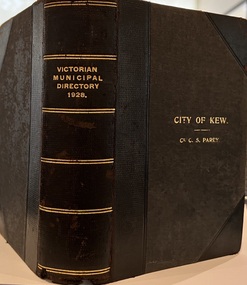 Kew Historical Society Inc
Journal, Arnall & Jackson: Printers & Stationers, Victorian Municipal Directory and Gazetteer : Also Commonwealth Guide and the Water Supply Record for 1928
The Victorian Municipal Directory provided annual details, and later bi-annual details, of all councils. Published by Arnall & Jackson (Printers and Stationers), copies were published in 'cloth' for sixteen shillings and 'half roan' for eighteen shillings. This copy was owned by Cr C.S.Parry. Elected to the Kew City Council as a representative of North Ward, Cr Parry was elevated to the position of Mayor in 1931. It, together with five other editions, was presented to the Kew Historical Society in 1987 by his grandson.Bound copy of the Victorian Municipal Directory and Gazetteer: Also Commonwealth Guide and the Water Supply Record for 1928. The volume contains 846 pages and includes sections on: - Comparative table – Municipal Returns for Twenty-one Years. - Index to Townships, Parishes and Railway Stations. - Changes and appointments. - Commonwealth of Australia (Constitution, Parliament, Departments and Officers). - State of Victoria (Parliament, Departments and Officers / Boards, Institutions, Trusts and Loans). - Municipalities in Victoria (Cities and Towns, Boroughs, Shires). - Water Supply (State Rivers and Water Supply Commission).non-fictionThe Victorian Municipal Directory provided annual details, and later bi-annual details, of all councils. Published by Arnall & Jackson (Printers and Stationers), copies were published in 'cloth' for sixteen shillings and 'half roan' for eighteen shillings. This copy was owned by Cr C.S.Parry. Elected to the Kew City Council as a representative of North Ward, Cr Parry was elevated to the position of Mayor in 1931. It, together with five other editions, was presented to the Kew Historical Society in 1987 by his grandson. victoria -- registers -- periodicals., victoria -- directories., water-supply -- victoria -- directories., municipal government -- victoria -- periodicals., cities and towns -- victoria -- directories. -
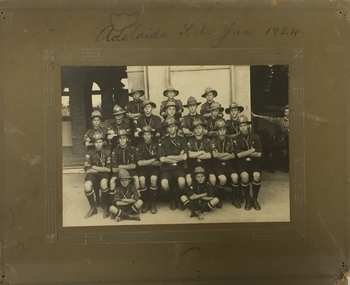 Kew Historical Society Inc
Photograph, 1st Kew Scouts - Adelaide SA Jan 1924, 1924
The group was most likely en route to the Australian Corroboree, which in 1924 was held at the Adelaide Exhibition Oval. The building in the background is likely to be the railway station, as travelling by train would have been the main method of inter-capital city transport in those days. The ‘Corroboree’ involved a large gathering of Scouts from across Australia. They would have pitched tents to live in, and participated in activities such as swapping badges, visiting the city, going on day trips, putting on concerts and displays, and spending time preparing their own meals.Adelaide SA Jan 19241st kew scouts, south australian corroboree 1924, kew - scouts -
 Kew Historical Society Inc
Map, MMBW, MMBW Plan No.67 Kew, 1900-1910
The Melbourne and Metropolitan Board of Works (MMBW) was established by an act of the Victorian Parliament in 1890 to prepare for and to implement a sewerage and water reticulation system across what was then inner Melbourne, its surrounding and middle distance suburbs, including Kew. The MMBW was disbanded in 1991.The map collection of the Kew Historical Society has at its core the historic maps assembled and originally stored in the City Engineer's Department of the City of Kew. These include maps in a number of scales. The vast majority of maps were produced by the MMBW in the first two decades of the twentieth century, and are solid working maps, backed by linen for durability. These maps are historically significant to Kew, the City of Boroondara and to the history of the development of state utilities in Victoria. A number of the Kew maps have additional details added by former municipal officers, including the levels reached by various floods. As these were working documents, information was added to them long after the period of their initial production and distribution.Early map of part of the Borough of Kew, created in the first decade of the twentieth century, at a scale 160 ft to 1 inch. The map covers what was then the north central part of Kew, bordered on its north by the Outer Circle Railway Spruzen and Beresford Avenues, in the west by Princess Street, in the south by High Street, and in the east by (about) Belford Road. The map shows the extent of urban development by that time, prominent institutions and the outlines of built structures in the municipality. Contour lines were added in ink to the map at a later stage.MELBOURNE AND METROPOLITAN BOARD OF WORKS / PLAN NO. 67 / KEW melbourne & metropolitan board of works, mmbw maps, mmbw plans, borough of kew, cartography -
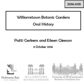 Williamstown Botanic Gardens- Hobsons Bay City Council
Oral History_Williamstown Botanic Gardens_Gerkens and Gleeson, 03/10/2014
The interview is one of a series recorded in 2013-2014 to document memories and experiences of the Williamstown Botanic GardensA primary source of information on memories of the Gardens and witness to changes in the Gardens over those years.CD and transcript of interview with Patti Gerkens and Eileen Gleeson and their memories of the Gardens from their childhood through to adulthood. Pattie and Eileen are the daughters of Jack and Millie Gerkens who lived in Power Street, Williamstown before moving to 25 Gellibrand Street, Williamstown. Jack worked at the Newport Railway Workshops. Patti lived overseas for many years and Eileen has lived in Williamstown all her life. Patti and Eileen recall memories of the Gardens during their childhood and of taking their own children there during the 1960s and 1970s. pattie-gerkens, eileen-gleeson, jack-gerkens, millie-gerkens, newport-railway-workshops, fish-pond, fountain, yoga, father-cassidy, con-gleeson, palms, williamstown-botanic-gardens, hobsons-bay-city-council -
City of Kingston
Photograph - Colour, c. 1993
Patterson Lakes is a suburb in the City of Kingston that is built one kilometre upstream of the mouth of the Patterson River. The area is bordered by the Patterson River and Eel Race Drain which enters the Kananook Creek. The suburb consists predominantly of newer housing developments and the tidal canal system of the development joins Port Phillip Bay.Patterson Lakes and the Kananook Creek were previously part of the extensive Carrum Carrum Swamp. The area was once a source of fish and eels for the Mayone-Bulluk clan of the Bunurong people. Over time the area was drained and in 1973 investigations commenced into the development of a unique residential area that would be built adjacent to canals and waterways. It was originally proposed to be known as "Gladesville". The development would give the suburb's homeowners access to Port Phillip Bay "from their back door". Circa 1974, the area was rezoned from rural to residential and named Patterson Lakes. Development has been continuous since the 1970s with construction of residential housing, schools, shopping centres, marinas, a hotel and library.Laminated colour aerial photograph of the Carrum and Patterson Lakes region within City of Kingston. This 1993 image includes Patterson River Secondary College, Roy Dore Reserve, Kananook Creek and Nepean Highway. The railway line can be seen as it veers inland from Eel Race Road, Seaford. The section of Palm Beach Drive, Curlew Point Drive, Snapper Point Drive, Clipper Island and Myola Street in Patterson Lakes appears to be a recent development with many spare blocks and new houses under construction.patterson lakes, seaford, kananook creek, carrum carrum swamp, canals and waterways -
City of Kingston
Photograph - Colour, 29 January 1993
Bonbeach, Carrum and Patterson Lakes are suburbs in the City of Kingston. Bonbeach and Carrum were holiday destinations in early 20th century and over time the housing has converted to permanent residential structures. In Patterson Lakes, the area consists predominantly of newer housing developments and the tidal canal system which is accessible to many dwellings joins Port Phillip Bay.Bonbeach, Carrum and Patterson Lakes were previously part of the extensive Carrum Carrum Swamp. The area was once a source of fish and eels for the Mayone-Bulluk clan of the Bunurong people. Over time the area was drained and this allowed farming at Carrum and Bonbeach, although the area was prone to flooding. In the early 1920s and 30s the land was converted to residential dwellings. In 1973 investigations commenced nearby to Bonbeach and Carrum into the development of a unique residential area comprising canals and waterways. It was originally proposed to be known as "Gladesville". Circa 1974, the area was rezoned from rural to residential and named Patterson Lakes. Development has been continuous since the 1970s with staged construction of the waterways, residential housing, and supporting infrastructure and facilities.Laminated colour aerial photograph of the Bonbeach, Carrum and Patterson Lakes region within City of Kingston. This 1993 image includes Bonbeach High School prior to demolition, Bonbeach Primary School and Patterson River Golf Club. Sections of Patterson Lakes are not yet developed, including Rhode and Staten Islands. Long Island Point appears to be a recent development with many spare blocks and new houses under construction. The Patterson River marina is prominent and the river mouth as it meets Port Phillip Bay. The Carrum railway station is visible.Black type on white adhesive sticker: No. 6661 Black type on white adhesive sticker: 26E/6661, 29/1/93, 4.25 pm Black type on white adhesive sticker 29-1-93 Yellow circular adhesive stickerbonbeach, carrum, patterson lakes, patterson river, carrum carrum swamp, canals and waterways -
City of Kingston
Photograph - Black and white, 17 January 1951
Moorabbin, Cheltenham and Highett are suburbs in the City of Kingston with a diverse mix of development and zoning. This 1954 image shows the market gardens, farms and paddocks of the Moorabbin and Cheltenham area. which have gradually been sub-divided into The Highett Gas Works is visible and Cheltenham Park and Victoria Golf Club.The suburbs of Cheltenham and Moorabbin were originally developed with extensive market gardens. Over time the district has been transformed with the farms and paddocks replaced by housing, factories and shopping centres. The Highett Gas Works on the Nepean Highway was a significant feature of the landscape and has now been demolished. and the site has undergone remediation.Aerial photograph of Cheltenham, Moorabbin and Highett within the City of Kingston. The area depicted in this 1951 aerial view includes Wickham Road, Highett (bottom right), Keys Road, Moorabbin (bottom left), Centre Dandenong Road Cheltenham (top left), Park Road, Cheltenham (top right), Nepean Highway (left section), Graham Road and Middleton Street, Highett (bottom right). Cheltenham Park and Victoria Golf Club are visible. Nepean Highway and the Frankston railway line run centrally through the image.White type: 1416-37 538 RUN239 LENS 5312" MELBOURNE METROPOLITAN 12150 17-1-51 ↆ M539 Black pencil: N [arrow]cheltenham, highett, highett gas works, market gardens -
 Melbourne Tram Museum
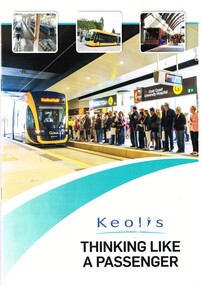
Magazine, Keolis Downer, "Keolis Thinking Like a Passenger", 2015
Booklet in magazine format, 16 A4 pages, full colour printed on gloss paper, titled "Keolis Thinking Like a Passenger", looking at Keolis's operations around the world including Melbourne and the Goldcoast. Has photos of various trams, light rail vehicles, map, locations. Includes photos of Bordeaux, Lyon, Dijon, Hyderabad, London Docklands, Lille, Melbourne, Bergen, Nottingham, Gold Coast, Stockholm (bus) and Las Vegas (bus). Published in association with the Light Railway and Transit Association for Tramways and Urban Transit in 2015.trams, tramways, keolis, light rail, melbourne, gold coast -
 Melbourne Tram Museum
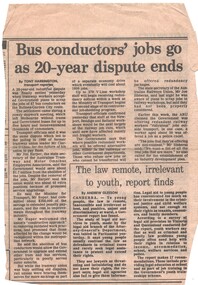
Newspaper, "Bus conductors' jobs to go as 20-year dispute ends", c1986
Newspaper Clipping - from an unknown paper, titled "Bus conductors' jobs to go as 20-year dispute ends" - about the agreement with the ATMOEA about the removal of bus conductors on the Bulleen - Garden City bus route. Quotes Mr. Tom Roper ( Minister) and Jim Harper (union secretary). Also notes railway disputes. c1986 (Tom Roper Minister for Transport 1985 - 1987) - http://www.parliament.vic.gov.au/re-member/details/1408-thomas-william-roper (accessed 3-11-2016). Item written by Tony Harringtontrams, tramways, buses, garden city, buses, conductors, unions, disputes -
 Melbourne Tram Museum
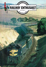
Magazine, William F Scott, "Times Past", Sep. 1995
Australian Railway Enthusiast Magazine - September 1995, pager 9 (note dated June 1995 on this page only), featuring photographs of cable trams with the heading "Times Past" with captions by William F. Scott. - cable car set - bogie trailer - side on view - bogie car 472 in Sydney Road - cable car set at South Melbourne terminus, Victoria St MMTB with the destination of North Fitzroy, c1923 Also has an obituary on Eldon Hogan who died on 6/5/1995.trams, tramways, cable trams, south melbourne, north fitzroy, bogie cable trailers, sydney rd, tram 472