Showing 30573 items
matching the hill
-
 Melbourne Tram Museum
Document, Melbourne & Metropolitan Tramways Board (MMTB), "MMTB Route Numbers - Bus Routes" 1961 & 1962
Provides a list of bus route numbers in 1961 and 1962. The 1962 sheet shows the additional routes following the take over of the bus routes in the Box Hill, Warrandyte and Ringwood areas.Yields information about bus route numbers.Set of two, Gestetner printed lists, foolscap sheets titled "MMTB Bus Routes Numbers". .1 - dated March 1961 - 1 sheet .2 - dated December 1962 - 2 sheetsItem 2 has "Obtained 2 May 1967" along top edge.tramways, trams, mmtb, route numbers, routes, buses -
 Clunes Museum
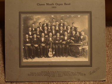
Photograph, "THORNTON" STUDIOS BALLARAT
IN MEMORY OF BERT McDONALD LATE OF BECKWITH STR. CLUNES. BORN - 10/12/1913 DIED - 3/9/1978 MARRIED JEAN ALLEN CAMP HILL CLUNES 1937.1 FRAMED PHOTOGRAPH OF CLUNES MOUTH ORGAN BAND 1933 WITH GUITAR AND DRUMS .4 ORIGINAL MOUNTED PHOTO WITH NAMES ON BOTTOM OF MOUNTING BOARD AND A COPY OF SAME24 MEMBERS , NAMES ON BOTTOM OF PHOTOlocal history, band, music, bands, mouth organ -
 Box Hill Historical Society
Ephemera - The Cavalcade of the Southern Cross: a pageant of Australian history, City of Box Hill, 1954
Souvenir programme compiled City of Box Hill Council presenting 'The Cavalcade of the Southern Cross' on 6 March 1954 in honour of the visit of Queen Elizabeth II. Featuring Chips Rafferty16 page booklet; includes b&w photos and b&w sketches. 3 copies, 2 of which are signed by Chips Rafferty.the cavalcade of the southern cross, royalty, 1954, rafferty> chips -
 Ringwood and District Historical Society
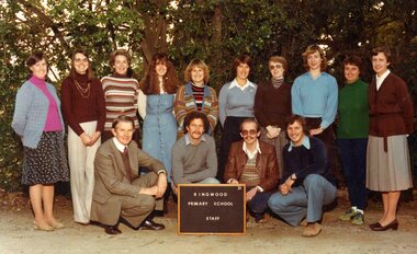
Photograph, Ringwood State School - Staff, 1979
Colour photograph - Staff, 1979"Attached to photograph" Back Row-L to R: Jeanette Cole, Judith Featherby, Doreen Turner, Rosemary Hill, Elizabeth Hrovda, Dianne Jones, Maureen Gray, Joanne Lawrence, Dawn Colville, Isabel Marshall. Front Row-L to R: Baden Chadwick (Principal), Stephen Gough, Tom Esala, Bruce Bower. -
 Ringwood and District Historical Society
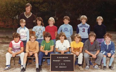
Photograph, Ringwood State School - 1st Cricket, 1978
Colour photograph - 1st Cricket, 1978."Attached to photograph" Back Row-L to R: Dijan Dinic, Jim Pumpa, Gavin Thorpe, David Hill, Greg Smith, Gavin Williams. Front Row- L to R: Werner Birkner, Peter Last, Matty Cane, Phillip Hagger, Peter Johnson, Mark Boehme, Paul Evans. Coach: Bruce Bower -
 Eltham District Historical Society Inc
Photograph - Digital Photograph, Alan King, Panton Hill Primary School, 27 March 2008
The Panton Hill Primary School building, which has served the community since 1889, was not the area's first. Kingston School (an early name for Panton Hill) opened in May 1865. This was replaced in 1871 when the Panton Hill School number 1134 opened and in 1874 the school moved to its current location [September 2023] where many additions and renovations have taken place to meet the needs of local children in the 21st century. Covered under Heritage Overlay, Nillumbik Planning Scheme. Published: Nillumbik Now and Then / Marguerite Marshall 2008; photographs Alan King with Marguerite Marshall.; p63 The Panton Hill Primary School building, which has served the community since 1889, was not the area’s first. In 1871 Henry Edelman opened a Common School in a paling-clad hut, replacing the Kingstown No 786 school. The two-acre (0.8ha) site of crown land had previously been held under Miners Right. In 1875 the Education Department bought a building on the main road for State School No 1134, for £200 and remodelled it as a school.4 Panton Hill had as one of its teachers, Frank Tate, who was to become one of Victoria’s most influential educational reformers. It was his first school, when he began teaching on January 22, 1884, as a 20 year old.5 The following month Robert J Harris was appointed to the school and remained as head teacher until his death in 1887. His son R C Harris was apprenticed to Mr Rossiter, editor of the first local paper. The Evelyn Observer, first published in 1873. Harris later bought the newspaper which remained a family business until the 1920s. J Hughes of Cherry Tree Road succeeded Harris as teacher at Panton Hill and sold his land for the school site. Though now unrecognisable, the school building includes the classroom of the last Smiths Gully State School No 1737, which was built in 1882, and moved to Panton Hill in 1894. From 1922 each school day began with the ringing of the bell, which is still in its stand, and is an unusually old memorial of this kind. To accommodate the growing population, the building was remodelled, with additions in 1923 and classrooms were added in 1955, 1963 and 1970. The former teacher’s residence is the only surviving 19th century dwelling in the centre of Panton Hill, and is now used as part of the school. The residence was originally rectangular but is now L-shaped. Similar weatherboard State School buildings in the shire from this period are the Kangaroo Ground and the St Andrews Primary Schools. All were standard Education Department/Public Works Department designs.This collection of almost 130 photos about places and people within the Shire of Nillumbik, an urban and rural municipality in Melbourne's north, contributes to an understanding of the history of the Shire. Published in 2008 immediately prior to the Black Saturday bushfires of February 7, 2009, it documents sites that were impacted, and in some cases destroyed by the fires. It includes photographs taken especially for the publication, creating a unique time capsule representing the Shire in the early 21st century. It remains the most recent comprehenesive publication devoted to the Shire's history connecting local residents to the past. nillumbik now and then (marshall-king) collection, panton hill primary school -
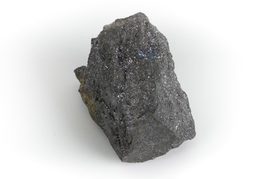 The Beechworth Burke Museum
Geological specimen - Galena Chalcopyrite, Unknown
Galena Chalcopyrite is the earth's primary ore of lead and is mined from a large number of deposits in many countries. It is also an important source of silver. Galena Chalcopyrite is one of the most abundant and widely distributed sulfide minerals across the world. The mineral is found in igneous and metamorphic rocks in medium- to low-temperature hydrothermal veins. This specific specimen was recovered from the mines in Broken Hill, New South Wales. The mines in Broken Hill were first established after Charles Rasp discovered a large amount of silver-lead-zinc ore-body in the area in 1883. BHP (Broken Hill Proprietary) mining company was then established in 1885 and quickly became the lead in Australia's mining industry after they began excavating and exporting the country's largest amount of lead, silver, and zinc. This feat generated over $100 billion in wealth for the company.Galena Chalcopyrite is signifiant as it represents the catalyst for the rise of Australia's most influential mining companies - BHP. The mineral was one of the first to be mined in the country and after being made into lead, was used for a variety of things such as paint, batteries, ammunition, and plumbing materials before it was known to be harmful to humans. This specimen is part of a larger collection of geological and mineral specimens collected from around Australia (and some parts of the world) and donated to the Burke Museum between 1868-1880. A large percentage of these specimens were collected in Victoria as part of the Geological Survey of Victoria that begun in 1852 (in response to the Gold Rush) to study and map the geology of Victoria. Collecting geological specimens was an important part of mapping and understanding the scientific makeup of the earth. Many of these specimens were sent to research and collecting organisations across Australia, including the Burke Museum, to educate and encourage further study. A grey, solid hand-sized lead sulfide mineral with a silver metallic luster.burke museum, beechworth, geological, geological specimen, galena, galena chalcopyrite, chalcopyrite, broken hill, bhp, bhp mining, broken hill mine, mine, australia mine, lead, lead mine -
 The Beechworth Burke Museum
Postcard, c1910
Mayday Hills Mental Hospital was originally constructed in 1864 under the name of the Beechworth Lunatic Asylum. It was built for locals in need of help who were kept in the local gaol. In its first decade, the residents of the hospital were used as menial labourers but over time, as mental healthcare progressed, were cared for in more nuanced ways. This site became a training hospital for nurses in the 1960's. Eventually, mental health patients were moved to other care facilities and Mayday Hills was operating as a geriatric care facility. It was closed in 1995, after which the buildings and their grounds were purchased to La Trobe University to be used as a campus. The university sold the site in 2011 to private ownership. This postcard depicts the Mayday Hills Mental Hospital (Titled as 'Asylum for insane') from a distance and includes the surrounding grounds and farmlands.Mayday Hills Mental Hospital is a historically significant site for many factors. It is representative of healthcare practice in nineteenth century Victoria. It contains rare examples of construction and architecture. It is also significant for aesthetic and technical reasons.Sepia tone postcard printed on matte cardObverse: Beautiful Beechworth (Vic.) 1880 ft. above Sea Level - General View of Asylum for Insane/ Copyright F. Foxcroft Reverse: 1997.2459/ Post Card/ THIS SPACE MAY BE USED FOR CORRESPONDENCE/ THIS SPACE FOR NAME AND ADDRESSmayday, mayday hills hospital, mayday hills, mayday hills mental asylum, mayday hills mental hospital, beechworth, beechworth asylum, beechworth hospital for the insane, beechworth lunatic asylum, beechworth mental hospital, healthcare, health, rural australia, farm, architecture, historic victorian architecture, classical architecture -
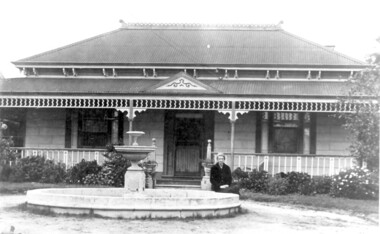 Surrey Hills Historical Society Collection
Photo, 'Spenceycroft', Canterbury Road
The photo is of ‘Spenceycroft’ at 654 Canterbury Road, Surrey Hills. For many years this home was hidden behind a large fence sheltering it from the noise of traffic along Canterbury Road, however it dates back to the very early days of settlement in the Surrey Hills area. Canterbury Road was then known as Delany’s Road. ‘Spenceycroft’ is thought to incorporate part of the original farmhouse built on the site by George Klepper, who planted a vineyard in the area. George’s family was one of a number of German families who settled in Surrey Hills during the later part of the 19th century. Later, the land associated with ‘Spenceycroft’ was worked as a dairy farm by James and Elizabeth Rayment. In recent years 'Spenceycroft' has been sold several times and has become increasingly derelict. Sold again in 2015 when it had become quite derelict, it was demolished and re-developed.A black & white photo of double-fronted Victorian style home with a fountain centre front and low foliage in front of the veranda. A woman is sitting by the fountain. 'spenceycroft', canterbury road, james rayment, elizabeth rayment, george klepper -
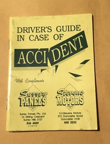 Surrey Hills Historical Society Collection
Booklet - Advertising booklet, Driver's guide in case of accident, c1991
Surrey Panels was started by Maurice Dalzell (Maurie) Costello (1918-2000) in 1948, soon after the first Holden was released. Maurie later brought his sons Alan, Robert and Brian into the business. F H Stevens Motors started in North Balwyn at a similar time and in 1982 was taken over by the Costello brothers, with Robert as General Manager. Members of the Costello family have been around the Surrey Hills area for many decades. Maurie’s parents Thomas Maurice and Mabel Isabel Costello lived at 43 Box Hill Crescent, Mont Albert North. Thomas was a cattle dealer and related to the Costellos of Costello’s Jersey Dairy (demolished) in Mont Albert Road, Balwyn. Prior to starting the business Maurie is listed as a market gardener living with his parents in Box Hill Crescent. He married Mavis Jean Guillerme in 1942. Surrey Motors and Surrey Panels are well known businesses serving the Surrey Hills community for decades.A small booklet, yellow in colour, designed to fit in the glove box of a car. It is stapled on the spine in 2 places and consists of 12 pages. Some pages are designed for the owner to fill in with their personal details. There is advice regarding emergency phone calls, what to do in the event of an accident, towing, 'at fault' information, insurance, location and services of Surrey Panels and F H Stevens Motors. There is a brief history of these linked businesses. There is a separate loose sheet designed to be completed in the event of an accident.Nilsurrey motors, surrey panels, maurice dalzell (maurie) costello, f h stevens motors, alan costello, robert costello, brian costello, canterbury road, stirling crescent, surrey hills, ephemera, car accidents, motor vehicle repairs -
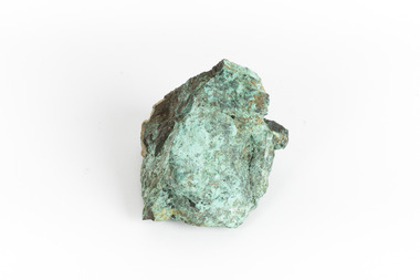 The Beechworth Burke Museum
Geological specimen - Copper Ore
This specimen was recovered from Silverton Mine in Broken Hill, New South Wales. Otherwise known as the 'Day Dream Mine', the Silverton Mine was first established in 1883, when silver and lead deposits where discovered. Within a few short years, the population of Broken Hill reached 3000 people. As of today the Silverton Mine is still open, and has produced over 200 million tonnes of ore, which has generated over $100 billion. The Silverton Mine was also famous for a number of specimens such as silver, iron and zinc.Copper is considered to be a rare ore in that finding it in its pure form is rare. Nowadays when mining for Copper it is often found in mixed in with other minerals or it is recycled from use. Moreover, Copper is found in a range of everyday uses such as coins, cookware, pipes, heating conductors and anything that generate electricity. The fact that Copper is heat a heat conductor, electricity conductor and it does not corrode easily, makes this ore a versatile and useful. This specimen is part of a larger collection of geological and mineral specimens collected from around Australia (and some parts of the world) and donated to the Burke Museum between 1868-1880. A large percentage of these specimens were collected in Victoria as part of the Geological Survey of Victoria that begun in 1852 (in response to the Gold Rush) to study and map the geology of Victoria. Collecting geological specimens was an important part of mapping and understanding the scientific makeup of the earth. Many of these specimens were sent to research and collecting organisations across Australia, including the Burke Museum, to educate and encourage further study.A solid hand-sized cube-shaped sulfide and oxide with shades of green, grey and brown throughout. Copper is typically found as nuggets in the ground. It can be found in a range of forms such as its native state; mixed with other ores, such as zinc and iron; as porphyry copper deposits; and as major deposits. Porphyry deposits are when the mineral is scattered evenly throughout the rock. Major deposits are when the mineral is scattered amongst other minerals.burke museum, beechworth, indigo shire, beechworth musum, geological, geological specimen, mineraology, copper, copper ore, copper ore speciment, broken hill, new south wales -
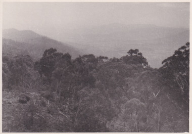
 The Beechworth Burke Museum
Photograph, 1944
Taken in 1944, the photograph depicts the surrounding farmland from Mt. Stanley in Victoria. A secret experimental micro-wave radio station was established and tested at this site by the Army Signal Detachment Unit during World War II. It was part of an experimental Ultra High Frequency (UHF) link between Melbourne and Sydney. At the time, it was highly classified. It intended to enquire into the hitherto unexplored transmission of micro-waves; that is, a radio signal which could only be transmitted by line of sight, and thus required hill-top to hill-top location.The photograph is historically significant as it pertains to World War II; the largest global conflict in history. This significance is enhanced by Australia's prominent involvement in campaigns across the Pacific, particularly on land in New Guinea and across the Huon Peninsula. It was also the first time that the Australian mainland came under direct attack by the Axis, with Japanese forces targeting north-west Australia and Sydney Harbour. These battles became Australia's largest and most complex offensives during the war. The record is also historically significant as it relates to the Royal Australian Corps of Signals, or "RA Sigs". This significance is strengthened by Australia's unique distinction of having the first established signal unit under the British Empire. This unit provides electronic warfare. They enable commanders to implement highly dynamic battle control against opposing forces by using a number of methods including radio, fibre optic, micro-wave, information systems and satellite links. The record has strong research potential. This is due to the ongoing scholarly and public interest in war, military history, the ANZAC legend, and the ongoing existence of the RA Sigs. The historic context of this record can provide insight into Australia's history, military, technological innovation and advancements, as well as national economic, defence and foreign policies after 1945. Black and white rectangular photograph printed on matte photographic paper.Reverse: BMM5095.1 /military album, army album, wwii, world war ii, army signal detachment unit, mt. stanley, beechworth, victoria, 1940s, australian army, melbourne, sydney, royal australian corps of signals -
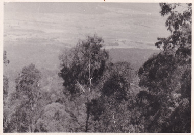
 The Beechworth Burke Museum
Photograph, 1944
Taken in 1944, the photograph depicts the view from Mt. Stanley. A secret experimental micro-wave radio station was established and tested at this site by the Army Signal Detachment Unit during World War II. It was part of an experimental Ultra High Frequency (UHF) link between Melbourne and Sydney. At the time, it was highly classified. It intended to enquire into the hitherto unexplored transmission of micro-waves; that is, a radio signal which could only be transmitted by line of sight, and thus required hill-top to hill-top location.The photograph is historically significant as it pertains to World War II; the largest global conflict in history. This significance is enhanced by Australia's prominent involvement in campaigns across the Pacific, particularly on land in New Guinea and across the Huon Peninsula. It was also the first time that the Australian mainland came under direct attack by the Axis, with Japanese forces targeting north-west Australia and Sydney Harbour. These battles became Australia's largest and most complex offensives during the war. The record is also historically significant as it relates to the Royal Australian Corps of Signals, or "RA Sigs". This significance is strengthened by Australia's unique distinction of having the first established signal unit under the British Empire. This unit provides electronic warfare. They enable commanders to implement highly dynamic battle control against opposing forces by using a number of methods including radio, fibre optic, micro-wave, information systems and satellite links. The record has strong research potential. This is due to the ongoing scholarly and public interest in war, military history, the ANZAC legend, and the ongoing existence of the RA Sigs. The historic context of this record can provide insight into Australia's history, military, technological innovation and advancements, as well as national economic, defence and foreign policies after 1945.Black and white rectangular photograph printed on matte photographic paper.Reverse: BMM5095.3 / 32 /military album, army album, beechworth, victoria, mt. stanley, australian army, wwii, world war ii, royal australian signal corps, army signal detachment unit -
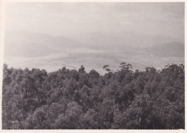 The Beechworth Burke Museum
Photograph, 1944
Taken in 1944, the photograph depicts the view from Mt. Stanley. A secret experimental micro-wave radio station was established and tested at this site by the Army Signal Detachment Unit during World War II. It was part of an experimental Ultra High Frequency (UHF) link between Melbourne and Sydney. At the time, it was highly classified. It intended to enquire into the hitherto unexplored transmission of micro-waves; that is, a radio signal which could only be transmitted by line of sight, and thus required hill-top to hill-top location.The photograph is historically significant as it pertains to World War II; the largest global conflict in history. This significance is enhanced by Australia's prominent involvement in campaigns across the Pacific, particularly on land in New Guinea and across the Huon Peninsula. It was also the first time that the Australian mainland came under direct attack by the Axis, with Japanese forces targeting north-west Australia and Sydney Harbour. These battles became Australia's largest and most complex offensives during the war. The record is also historically significant as it relates to the Royal Australian Corps of Signals, or "RA Sigs". This significance is strengthened by Australia's unique distinction of having the first established signal unit under the British Empire. This unit provides electronic warfare. They enable commanders to implement highly dynamic battle control against opposing forces by using a number of methods including radio, fibre optic, micro-wave, information systems and satellite links. The record has strong research potential. This is due to the ongoing scholarly and public interest in war, military history, the ANZAC legend, and the continuing existence of the RA Sigs. The historic context of this record can provide insight into Australia's history, military, technological innovation and advancements, as well as national economic, defence and foreign policies after 1945.Black and white rectangular photograph printed on matte photographic paper.Reverse: BMM5095.4 / 32 /military album, army album, wwii, world war ii, mt stanley, beechworth, victoria, melbourne, sydney, royal australian corps of signals, army signal detachment unit, military, war -
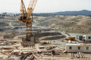
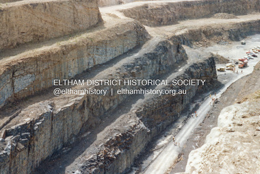
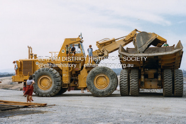 Eltham District Historical Society Inc
Photograph - Colour Print, Lewis Tulk, Construction Winneke Reservoir and treatment plant / Melbourne and Metropolitan Board of Works, c.1981
Sugarloaf Reservoir is situated on former farmland. This large water storage was completed in 1982 and serves Melbourne's northern suburbs. Within the visitor areas are two picnic grounds and other recreational facilities. Below its massive rock embankment is located the Winnecke Treatment Plan designed to purify its water before being piped into Melbourne. The dam partly inundated the old firing ranges of the former Christmas Hills Rifle Club. Source: Christmas Hills Now and then: Yarra Glen & District Historical Society, 2004.lewis tulk collection, construction, sugarloaf reservoir, winnecke dam -
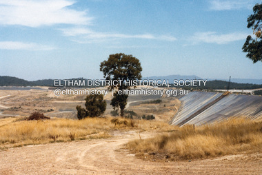
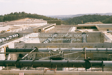
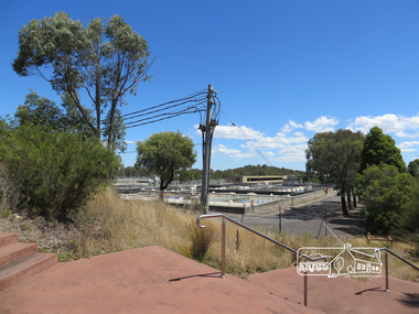
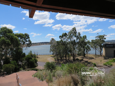 Eltham District Historical Society Inc
Photograph, Sugarloaf Reservoir, Christmas Hills, 16 January 2015, 16 January 2015
Sugarloaf Reservoir is situated on former farmland. This large water storage was completed in 1982 and serves Melbourne's northern suburbs. Within the visitor areas are two picnic grounds and other recreational facilities. Below its massive rock embankment is located the Winnecke Treatment Plan designed to purify its water before being piped into Melbourne. The dam partly inundated the old firing ranges of the former Christmas Hills Rifle Club. Source: Christmas Hills Now and then: Yarra Glen & District Historical Society, 2004. Born Digitalchristmas hills, sugarloaf reservoir -
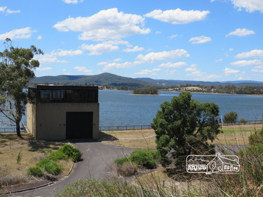
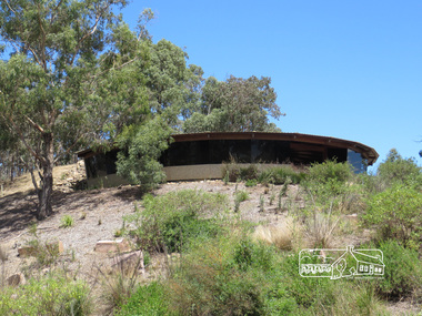
 Eltham District Historical Society Inc
Photograph, Sugarloaf Reservoir, Christmas Hills, 16 January 2015, 16 January 2015
Structure at Sugarloaf. Sugarloaf Reservoir is situated on former farmland. This large water storage was completed in 1982 and serves Melbourne's northern suburbs. Within the visitor areas are two picnic grounds and other recreational facilities. Below its massive rock embankment is located the Winnecke Treatment Plan designed to purify its water before being piped into Melbourne. The dam partly inundated the old firing ranges of the former Christmas Hills Rifle Club. Source: Christmas Hills Now and then: Yarra Glen & District Historical Society, 2004. Born Digitalchristmas hills, sugarloaf reservoir -
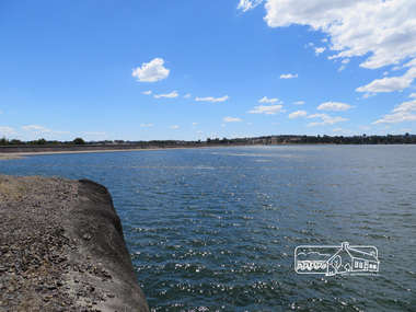
 Eltham District Historical Society Inc
Photograph, Sugarloaf Reservoir, Christmas Hills, 16 January 2015, 16 January 2015
Sugarloaf Reservoir is situated on former farmland. This large water storage was completed in 1982 and serves Melbourne's northern suburbs. Within the visitor areas are two picnic grounds and other recreational facilities. Below its massive rock embankment is located the Winnecke Treatment Plan designed to purify its water before being piped into Melbourne. The dam partly inundated the old firing ranges of the former Christmas Hills Rifle Club. Source: Christmas Hills Now and then: Yarra Glen & District Historical Society, 2004. Born Digitalchristmas hills, sugarloaf reservoir -
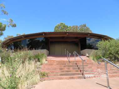
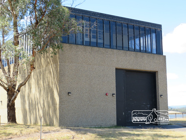
 Eltham District Historical Society Inc
Photograph, Sugarloaf Reservoir, Christmas Hills, 16 January 2015, 16 January 2015
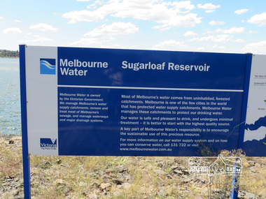
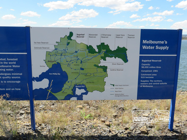
Sugarloaf Reservoir is situated on former farmland. This large water storage was completed in 1982 and serves Melbourne's northern suburbs. Within the visitor areas are two picnic grounds and other recreational facilities. Below its massive rock embankment is located the Winnecke Treatment Plan designed to purify its water before being piped into Melbourne. The dam partly inundated the old firing ranges of the former Christmas Hills Rifle Club. Source: Christmas Hills Now and then: Yarra Glen & District Historical Society, 2004. Born DigitalMelbourne Water Sugarload reservoir Melboure Water is owned by the Victorian Government. We manage Melbourne's water supply catchments, remove and treat most of Melbourne's sewrage, and manage waterways and major drainage systems. Most of Melbourne's water comes from uninhabited, forested catchments. Melbourne is one of the few cities in the world that has protecyed water supply catchments. Melbourne Water manages these catchments to protect our drinking water. Our water is safe and pleasant to drink, and undergoes minimal treatment - it is better to start witht he highest quality source. A key part of Melbourne Water's responsibility is to encourage the sustainable use of this precious resource. For more inforamtio on our water supply and on how you can conserve water, call 131 722 or visit www.melbournewater.com.auchristmas hills, sugarloaf reservoir, sign, melbourne water -
 Eltham District Historical Society Inc
Photograph, Sugarloaf Reservoir, Christmas Hills, 16 January 2015, 16 January 2015
Sugarloaf Reservoir is situated on former farmland. This large water storage was completed in 1982 and serves Melbourne's northern suburbs. Within the visitor areas are two picnic grounds and other recreational facilities. Below its massive rock embankment is located the Winnecke Treatment Plan designed to purify its water before being piped into Melbourne. The dam partly inundated the old firing ranges of the former Christmas Hills Rifle Club. Source: Christmas Hills Now and then: Yarra Glen & District Historical Society, 2004. Born Digitalchristmas hills, sugarloaf reservoir, signage -
 Federation University Historical Collection
Photograph - Colour, Ron Cosgrave, Laura Villa, Smeaton, 2013, 07/2013
In July 2013 Smeaton resident Ron Cosgrave offered to attempt to find Laura Villa. He wrote on 12/07/2013 "I have attached three photographs of Laura Villa as it is today. I am 100 % that it is the house in question. The changes are the veranda and numerous alterations and attachments. The key identifiers are the original roof line, the chimney, the trees and the background of the photo is the other side of Birch’s Creek with similar trees and the hill is Green Hill. It is located at the end of Elizabeth Street on the south side of the creek and at the Recreation Reserve." Three colour photographs of a weatherboard house. It is the former Smeaton home of Frank Wright.frank wright, music, smeaton, laura villa -
Bendigo Historical Society Inc.
Document - Bendigo Tramways Brochure, abt 1950s
In 1890 Bendigo's first tramway battery-electric carriages operated between Sanhurst and Eaglehawk. In 1892 Battery-electrics were replaced by steam tram cars on the Bendigo Railway Station track to Eaglehawk. In 1903 Electric traction overhead was inaugurated extending to Quarry Hill, Golden Square and Lake Weeroona. In 1913 Open cross-seat cars added for the service Quarry Hill to Eaglehawk. In 1945 Traction bogie cars replaced older cars. In 1947 Birney safety cars (dead man controllers) replaced older carsBrochure, a "Welcome to Bendigo, and "Evolution of Bendigo Tramways." 8668.1 Brochure is titled "Welcome to Bendigo," on the front a photo of Charing Cross and Trams, also the Bendigo City Coat of Arms. Inside two pages and descriptions of six tram showing the "Evolution of Bendigo tramways." On the rear is a map of the tramways and places of interest to visit. The brochure was "Printed for the preservation committee in co-operation with the Royal Historical Society of Victoria (Bendigo and District Branch) All donations for a preservation fund."history, bendigo tramways, evolution of bendigo tramways