Showing 10881 items
matching land
-
 Bendigo Military Museum
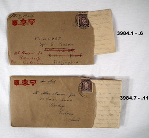
Letter - LETTERS & ENVELOPES
.1) - .5) The letter is from VX137222 Allan Frederick Hutson 28 Aust INF BN AIF Aust dated 9 Dec 1945 to VX 140967 Alan Mason of 25 Queen St Bendigo .6) The letter is written from Rabaul re life there, what’s happening while waiting to come home. .7) - .10) The letter is to Alan Mason from a mate, no name mentioned from his unit “GDD” in Morotai on 12.12.1945. “GDD” meaning General Details depot. The letter is mostly about complaints re food, conditions and organising a March and protest to the unit “CO”. Two senior Officers are mentioned, “Col Barrett and Col Wade”. The letter quotes up to 5000 marched to Land HQ. Mason and Hutson were mates from Bendigo. Refer Cat No 3979.2 for Alan Masona service details..1) - .5) Letter on yellowed paper, all lettering and logo’s and lines in red from a combined group being “YMCA”, “Aust Comforts Fund” and “The Salvation Army”. At the bottom is information regarding security.Five pages written on one side only in blue pen. .6) Envelope, brown colour, Air Mail with the same 3 Logo’s as in .1) - .5) Addressed to A Mason. .7) - .10) Letter on yellowed paper, all lettering, logo’s and lines in red from the same 3 organisations as in .1) - 6) This letter does not have the security warning. Four pages, on one side except page 4 on both sides, written in blue pen. .11) Envelope, brown colour, AIR MAIL with the same 3 Logo’s, addressed to A Mason from a mate.letters, personal, stationary -
 Greensborough Historical Society
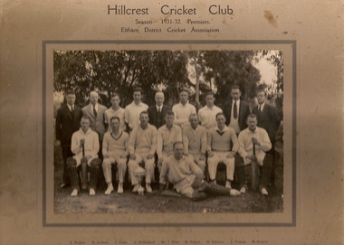
Photograph (copy), Hillcrest Cricket Club: photograph and article, 1931-1932
The Hillcrest Cricket Club is shown in the 1931-32 season. The photograph is named. The photo is accompanied by a handwritten short history of the club by Ray Hooper: "Hillcrest C.C.- Hillcrest Cricket Club was situated between Mountainview Road and … Street at the top of the hill. Where it became flat more or less where River Street met Mountainview Road (straight up). The land was owned by Mr J Ellis (senior) who allowed the local men to make a cricket pitch so they could form a cricket team and enter in the Eltham District Cricket Association (1925-1930). As you can see Mr Ellis Senior (by photo) became president and both his sons played for Hillcrest C.C. My father also played and I can just remember W Mills (Captain), H.Padget, H.Johnson, J.Parks and H.Weidlich (as I got older). Ray Hooper." Copy of group photograph and handwritten article.Group photograph is named.hillcrest cricket club, ray hooper -
 Kiewa Valley Historical Society
Photograph of Snow Covered Catchment Area Vic, Snow Covered Catchment Area Victorian Alps - 1950s, Circa 1950
This photograph details (early to mid1950s), the Victorian Alpine region when this remote area was part of a "lay back" rural landscape,occasionally visited by recreational adventurers and some wayward tourists. The mountain ranges had provided an adequate barrier against the way-would traveller, but with the opening up of this region by the provision of improved roadways and accommodation facilities, courtesy of the Kiewa Valley Hydro Electricity Scheme, changes such as tourism and its impact upon the "natural" state started to show its side effects (clearing of the land). The expansion of the European immigration numbers (1950s) coming into Australia was increasing after World War II which not only provided increased construction workers to the region but also immigrants who appreciated alpine regions. Some of these immigrants contributed to the expansion of the region and provided for a greater degree of diverse professions and rural related work force.This photograph depicts the borderline in time between an exclusively rural based population and respective activities(early 1900s)to the present (2000 on wards) integrated village, tourist and retiree/holiday area. The time when land was exclusively used in agriculture and Alpine grazing lands is over. The Kiewa Valley is loosing its hiding place and is becoming more and more a source of untapped residential land and winter time recreational adventure lands. The changes brought about by modern technologies involving recreational activities such as hang gliding, gliding (local airstrip), mountain bikes, car rallies and their associated clubs is providing for an increased short term population boost. These together with the attractions for retirees is changing not only the physical nature of the Kiewa valley but also its "soul".This item is a black and white photograph of a section of snow covered catchment area in the Victorian Alps in the mid 1900. It is on 200 gms paper but not on photographic paper and has a white boarder (3 mm).kiewa valley tourism, victorian alps, alternate energy supplies, alpine population growth -
 Orbost & District Historical Society
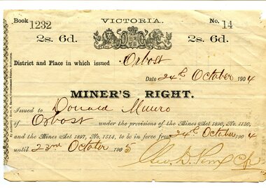
certificate, 24.10.1904
This miner's right certificate was issued in Orbost to Donald Munro of Orbost. It was valid from 24.10.1904 until 23.10.1905 and cost two shillings and sixpence. Donald Munro, with his brother, Archie carried on a boot-making business in one of the rooms of a three-storeyed barn at Lochiel. The Munros were musically inclined and through them a band was formed in 1889. Donald Munro was involved in many of the town's activities. (More in Mary Gilbert's Personalities and Stories of the Early Orbost District). The Miner's Right was introduced in 1855 in the colony of Victoria, replacing the Miner's Licence. Protests in 1853 at Bendigo with the formation of the Anti-Gold Licence Association and the rebellion of Eureka Stockade in December 1854 at Ballarat led to reform giving the right to mine gold, the right to vote, and the right to own land. This new system proved economical and sustainable, operating substantially unchanged up until 1975. This item is of historical significance as it is associated with positive outcomes for gold miners brought about by the Eureka Stockade rebellion and its subsequent democrat changes. It is also associated with the Munro family who were early settlers in Orbost.A white paper miner's right certificate. It has black print with hand-written details. It is an elaborate document with the Victorian coat-of-arms at the top.on back- date, hand-written notescertificate-miner's-right munro-donald -
 Orbost & District Historical Society
photograph, 1937
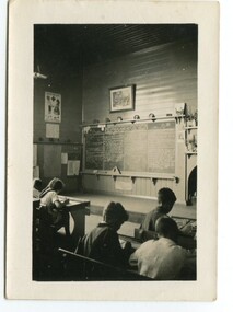
In 1912 the school at Pumpkin Point opened to serve the children of farmers living in the Bete Bolong district. This meant a big change in their way of life because in the past the children had been rowed across the Snowy River each day to attend school at Jarrahmond. Myrtle Bunting was the first HT of the school which had been erected on a block of land purchased from H. Richardson. The school functioned until 1952 when a shortage of pupils caused its closure. As a bus service to Orbost now operated, the school at Pumpkin Point faced permanent closure. J. McKeown bought the building. Students attending the school at this time included Russells, Johnstones, Reeves, Healeys, Kavanaghs, Phillips, Rodwells, Mills, Baileys, Gilberts and Masons. Mr. Oswald S. Green taught at Bete Bolong State School until he was appointed to Rokewood Junction in August 1937.This item is associated with the history of education in the Orbost district. There is no longer a school at Bete Bolong.A small black / white photograph of students sitting in a classroom.on back - "Bete Bolong School, 1937. O.S. Green was H.T."bete-bolong-school pumpkin-point green-o.s. -
 Orbost & District Historical Society
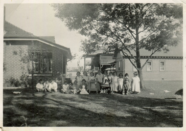
photograph, 1937
In 1912 the school at Pumpkin Point opened to serve the children of farmers living in the Bete Bolong district. This meant a big change in their way of life because in the past the children had been rowed across the Snowy River each day to attend school at Jarrahmond. Myrtle Bunting was the first HT of the school which had been erected on a block of land purchased from H. Richardson. The school functioned until 1952 when a shortage of pupils caused its closure. As a bus service to Orbost now operated, the school at Pumpkin Point faced permanent closure. J. McKeown bought the building. Students attending the school at this time included Russells, Johnstones, Reeves, Healeys, Kavanaghs, Phillips, Rodwells, Mills, Baileys, Gilberts and Masons. Mr. Oswald S. Green taught at Bete Bolong State School until he was appointed to Rokewood Junction in August 1937. This photograph is associated with the history of education in the Orbost district. There is no longer a school at Bete Bolong.A small black / white photograph of students and teachers standing outside a school.on back - " Bete Bolong School , 1937"bete-bolong-state-school education-orbost -
 Orbost & District Historical Society
black and white photographs, April 1916
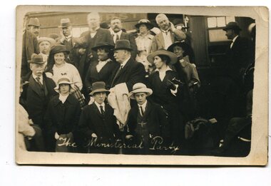
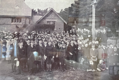
These photographs were taken at the official opening of the Orbost - Bairnsdale Railway Line. In 3150.3 which is of a group of children and two adults those identified in the photograph are ; L - R front row Mary Gilbert; Warren; Betty Gilbert; Marion Gilbert; Mrs Shaw and son; ? Gay; and Pen Gilbert. In 3150.4 L-R front " Mary Gilbert; Bet Gilbert (sitting with glasses); Pen Gilbert(Richardson); Marion Gilbert ( middle front little girl) About 1912 work began at Newmerella on clearing the track for the railway line from Bairnsdale to Orbost. A canvas town sprang up on the higher land adjacent to the river flats. Local farmers supplied meat, milk and fresh produce to the camp, as well as gaining employment carting and labouring. The line opened in 1916, the Orbost railway station being built on the Newmerella side of the river.This item is associated with the history of the Orbost-Bairnsdale railway line and therefore reflects the role that the rail line played in the social and economic history of Orbost. It is a pictorial record of a significant event in Orbost's history. On April 10 1916, the first scheduled train service left Orbost for Bairnsdale. The Bairnsdale-Orbost railway was opened to serve the agricultural and timber ndustry. Because of the decline in traffic and heavy operating costs, the line was finally closed in August, 1987. Four black / white postcards of people at the opening of The Orbost - Bairnsdale Railway. 3150.1 - on front - "The Ministerial Party" 3150.2 - on front - hand-written - " The Hon James Cameron" with arrow pointing to a man standing in the back row. at bottom - "The Ministerial Party X Florie Cameron" on back- "Opening the Orbost Railway" 3150.3 and 3150.4 - on back - hand-written "First train to Orbost with a list of names.orbost-bairnsdale-railway celebration-opening-of-railway east-gippsland-railway -
 Orbost & District Historical Society
black / white photograph, 1897
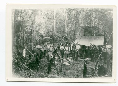
Link with item 1178. This is a surveyors' camp in the McCulloch Ranges, Murrangowar, April, 1897. Included in the photograph are: L. Thorn; Pearson; L. Coburn, Clem Bates; Sam Blacklock with a packhorse. They were surveying for a road or railway. Surveyors were among the first European settlers to arrive in Australia. A Surveyor-General was present on the First Fleet, as well as the first two ships which landed in South Australia. These men were issued with instructions to record observations in a journal that included the country’s general appearance, its soil, flora and fauna and the customs and language of local inhabitants. The conditions they worked in were harsh and they embarked on journeys with drays carrying cumbersome surveying and camping equipment, spending months camping out in the bush and mapping the land. It was not until well into the second half of the nineteenth century that the professional training of surveyors became mandatory in Australia.This is a pictorial record of a surveyors' camp in the late 19th century.A black / white photograph of a group of men standing in front of a tent / camp in a dense bush setting.surveyor's-camp-mccullochs-ranges-murrangowar land-settlement -
 Orbost & District Historical Society
black and white photographs, 1890s
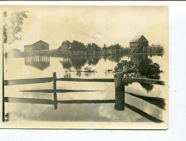
Peter Cameron, came to Orbost in 1885, at the age of 69, having sold his farm at Geelong. Peter bought the property ―Glen Avon from a Mr Street. The home was situated at the bottom of the paddock, near the corner of Morley and Livingstone streets. The farm stretched from Tennyson Street to the end of Snaggers Lane and along the river frontage to “Carinya” Cameron Home. In the Gippsland Times on Wednesday. 2 Jul 1890 on Page 3 is an article titled "THE SNOWY RIVER CALAMITY" which describes an ".unexpectedly sudden rush of water down the flats..... the terrified people commenced to remove their stock from the land and the work of saving property was continued all day ............ many head of cattle were washed away.......The river road, for its entire length, is obliterated, and the approaches to the bridge at Watt's Gulch are gone, with the enormous volume of flood water," These photographs are pictorial records of a significant event in the history of Orbost. There are few personal records of the very early floods.Three black / white photographs of wooden buildings with flood water in foreground. There are post and rail fences. 3193.2 has been taken from a distance.on back -" "Glenavon east of Lagoon 1897 Feb"floods-orbost-1890s glenavon-orbost -
 Orbost & District Historical Society
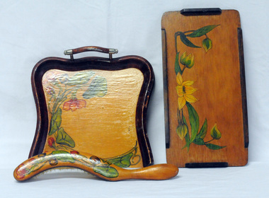
household items, 1935-1960s
These items are from the estate of Norma Adelaide Scott (nee Johnston) ,January 2, 1925 - May 18, 2018 (93 years old) who died in Orbost. Norma was part of the Morris family who came to Newmerella in 1888, had land on Grandview Road and on the flats. Mr Morris had been a school teacher at Lake Tyers Mission before coming to Orbost. "Bobs y’r Uncle" was a nursery rhyme game designed by Frank H. Simpson for John Waddington Ltd. in 1935. The game was especially designed for children. The cards had scenes from nursery rhymes and six cards were needed to make up each rhyme in a set. Games turned out to become an important part in the progress of Waddingtons, who eventually acquired the rights to Monopoly in the UK, and then published Cluedo, opening the way for their supremacy in the toy industry These items are examples of common household items used in an Orbost family in the first - mid 20th century.3228.1 is a wooden tray with handles. The tray is lacquered and hand - painted with green leaves and orange flowers. 3228.2 is a brush with a curved wooden handle, lacquered and decorated in a similar pattern of green leaves and flowers. 3228.3 is a small wooden tray, lacquered and hand -painted with green leaves and yellow flowers. It is a rectangular shape with raised edging attached on the four sides. 3229.4 is a pack of cards in a red box with a cartoon type drawing of a man wearing a checked coat and hat holding two dogs on leashes.3228.5 is an orange / white cardboard box containing a pair of nylon stockings: box labelled " 'KOLOTEX/ Free-n-eezy" stockings.3228,5 - in orange and white print - "KOLOTEX/ Free-n-eezy/ Clings/ 40 denier/ SEAMLESS/ S-T-R-E-T-C-H" and in black - "NEW guaranteed never to ladder"scott-norma cards-playing hosiery-kolotex-stockings trays-wooden household -
 Marysville & District Historical Society
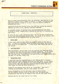
Flyer (Item) - Information Flyer, Forests Commission, Victoria, FOREST WALKS - MARYSVILLE, 1918-1983
An information flyer that was produced as a guide to the forest walks in and near Marysville by the Forests Commission of Victoria. The Forests Commission Victoria (FCV) was the main government authority responsible for management and protection of State forests in Victoria, Australia between 1918 and 1983. The Commission was responsible for ″forest policy, prevention and suppression of bushfires, issuing leases and licences, planting and thinning of forests, the development of plantations, reforestation, nurseries, forestry education, the development of commercial timber harvesting and marketing of produce, building and maintaining forest roads, provision of recreation facilities, protection of water, soils and wildlife, forest research and making recommendations on the acquisition or alienation of land for forest purposes″. An extensive network of walking tracks surrounds Marysville and they offer a variety of walks ranging in various levels of difficulty. This information flyer provides information such as the level of difficulty for six suggested walks around Marysville.An information flyer that was produced as a guide to the forest walks in and near Marysville by the Forests Commission of Victoria.marysville, victoria, australia, forest walks, forests commission victoria, beauty spot walk, tree fern gully walk, michaeldene track, keppel track, woods lookout track -
 Federation University Historical Collection
Booklet, Nelson Stedman, Napier Before and After the Earthquake of February 3rd 1931, c1931
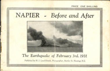
The earthquake at Napier, also known as the Hawke's Bay Earthquake, took place on 03 February 1931 at about 10.45 am. There was no warning before the ground started to heave and roll in waves. It was not possible to stand without support, and the violent motion caused stone and brick buildings to collapse into the streets causing death and injury to hundreds who were going about there daily business. Fires started almost immediately, and with the water mains shattered, the fire fighters were powerless to stop or prevent the spread of the flames. Within twelve hours the greater part of the business area of Napier and its port was totally destroyed. As a result of the pressure which caused the upheaval, the levels of the town and the surrounding district have been altered. The town and the harbour were raised from five to seven feet, and many parts of the inner harbour became dry land. Small booklet of 18 pages with photographic comparisons of New Zealand's Napier region before and after the 1931 earthquake.napier, new zealand, earthquake, lovell-smith, stedman, boston, port ahururu, westshore, clive square, hawke's bay -
 Federation University Historical Collection
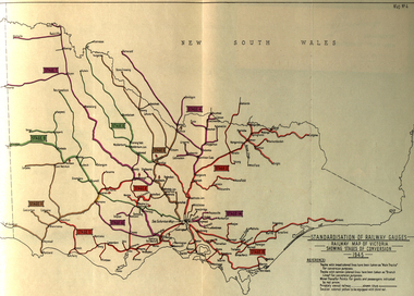
Book, Standardization of Australia's Railway Gauges, 1945, 1945
Sir Harold Winthrop Clapp KBE (7 May 1875 – 21 October 1952) was a transport administrator who over the course of thirty years had a profound effect on Australia's railway network. In two decades as its Chairman of Commissioners, he revolutionised Victorian Railways, with unprecedented attention to customer service and innovations such as more powerful locomotives, air-conditioned carriages, and faster services culminating in the introduction of the flagship Spirit of Progress express train. Seconded to the Federal Government in World War II, he played a pivotal role in the manufacture of fighter aircraft in the defence of Australia. As Director-General of Australia's Land Transport Board, he presented a report on railway gauge standardisation that ultimately led to the eventual linking of all Australian mainland capital cities by a uniform rail gauge. (http://en.wikipedia.org/wiki/Harold_Winthrop_Clapp, accessed 02/10/2013)Grey, soft covered, stapled report of 89 pages. "Standardization of Australia's Railway Gauges" by Harold Clapp is a report and recommendation regarding the standarization of Australia's railway gauges. The contents include: * Lines suggested for conversion or new lines to be constructed * scheme of conversion of tracks and structures * scheme of conversion of locomotives and rolling stock * Estimated costs * Associated works * Estimated manpower which the project will absorb in its various phases *Standardization of rolling stock * Other considerations associated with the project * Estimated time involved in the various phases of the work. The report includes 8 maps: * Map of Australia showing the various proposals referred to *Map of Australian railways showing extent of standard gauge if proposals are carried out * Map of Australian railways as of 30 June 1944 *Map of Australia showing principal mileages referred to in the report * Railway Map of Western Australia, 1945 * Railway Map of South Australia, 1945 * Railway Map of Victoria, 1945 * Railway Map of Melbourne Suburbs, 1945 railway, guage, standardization, standardisation, fremantle, perth, kalgoorlie, peterborough, silverton, tramway, tram, train, townsville, dajarra, bourke, cunnamulla, charleville, blackall, longreach, winton, hughenden, townsville, gajarra, birdum, darwin, narrow gauge -
 Federation University Historical Collection
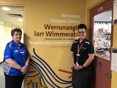
Photograph - Photographs - Colour, Renaming of the Wimmera Campus Library to Werrunangita larr Wimmerata, 2019, 11/2019
The dual-naming of the Wimmera Library took place in November 2019, and includes a name in local Wergaia language. The Horsham Campus is now known as “Werrunangity larr Wimmerata” (pronounced: Wherroon narn kitch – larr – wimmerartar) meaning “a quiet place in the Wimmera.” The official naming took place in the presence of Professor Helen Bartlett (Vice Chancellor who was joined by Aunty Jennifer Beer, Uncle Rob Fry, Geoff Lord (Horsham Campus Director) , Sue Owen (Library Director), Jasmine Graham (Manager of the Aboriginal Education Centre), Keith Caldwell (Facilities), Katrina Beer and artist Tanisha Lovett. This naming was the result of extensive teamwork and community consultation between local Aboriginal Elders, land councils, our Aboriginal Education Centre, as well as library and campus leadership. It is just one of the ways in which we are progressing our University’s Reconciliation Action Plan. Federation University librarians stand new artwork and signs for Werrunangita larr Wimmeratawerrunangita larr wimmerata, horsham campus, library, librarians, ann jardine, women -
 City of Moorabbin Historical Society (Operating the Box Cottage Museum)
Tools, large Saw, 2 man, c1900
Early settlers had to clear the land of trees and shrubs to establish and maintain their farms and market gardens. Some settlers worked in the Gippsland region felling timber for transport by bullock wagons to Melbourne. Two-man crosscut saws were primarily important when human power was used. Such a saw would typically be 1 to 4 m (4 to 12 feet) long, and sometimes up to 5 m (16 feet), with a handle at each end. The technique in using a two-man saw involved a sawyer standing at each end and together the sawyers would alternate pulling the saw through the wood. If the kerf -slit- began closing, causing the saw to bind, wedges would be inserted behind the saw blade in order to keep the kerf open.Two-man saws were designed to cut in both directions. Careful tooth design was necessary to clear the sawdust during the cut. This is a typical two-man tree felling saw that was necessary to clear the land when the pioneers were establishing their market gardens and farms in Parish of Moorabbin c1850A long steel blade saw with 2 wood handles c1900tools, saws, axes, early settlers, pioneers, market gardeners, dairy farms, orchards, vineyards, timber mills, bullock wagons, tree felling, timber mills, city of moorabbin, county of bourke, moorabbin roads board, parish of moorabbin, shire of moorabbin, henry dendy's special survey 1841, were j.b.; bent thomas, o'shannassy john, king richard, charman stephen, highett william, ormond francis, maynard dennis, -
 City of Moorabbin Historical Society (Operating the Box Cottage Museum)
Photograph, Black & White Methethodist Childrens Home Cheltenham , Dolls Tea Party 1935, 1935
A typical leisure activity for children of this era was a doll's tea party. The Methodist Children's Home in Cheltenham was founded c1880 to provide housing for neglected children from the inner city. The Founders aimed to provide regular nourishment, a stable environment and integrate the children into the local community thereby improving their education and lives. However new settlers to Cheltenham area who were seeking a healthier and more respectable lifestyle for their families were not happy to share Church and School with the Home's Children. (see 00561) 1950's saw a new direction for the support of children and families in poor and difficult situations . The new Burwood Homes Facility opened in 1951 and children were transferred from Cheltenham in 1952. The land was sold to the St John of God, Catholic Order in1953 who maintained an orphanage until Myer Pty Ltd bought the site in 1967 and constructed the Southland Shopping Centre c1892-1953 The Methodist Children's Home Cheltenham was founded to provide safe accommodation and education for neglected children from the inner city slums. Black & White photograph of Methodist Children's Home and Cottages combined 'Dolls Tea Party' Cheltenham 1935Back Handwritten informationmethodist childrens home cheltenham 1892-1953, dolls, city of moorabbin, county of bourke, moorabbin roads board, parish of moorabbin, shire of moorabbin, henry dendy's special survey 1841, were j.b.; bent thomas, o'shannassy john, king richard, charman stephen, highett william, ormond francis, maynard dennis, cheltenham state school no.84, methodist chapel cheltenham, methodist school cheltenham, beaumaris west state school, meeres frederick, meeres walter, education, early settlers, -
 City of Moorabbin Historical Society (Operating the Box Cottage Museum)
Photograph - B/W Bentleigh SS No.2083, 1920
The Common School No. 213 East Brighton 1864 - 1878 replaced the original St Stephen's Church of England School in Tucker Road. 1878-1908 the School was known as Education Department State School No. 2083 Brighton East. 1908 - 1936 the School changed it's name to Bentleigh and then from 1936 - 1993 was known as East Bentleigh. 1993 the school was closed due to low enrollments and the building was demolished and land sold. Eric Hutchinson, the uncle of Les Hutchinson, attended this school. Eric is second row far left ' behind the boy with the white handkerchief '. The 1920 gathering may be for the unveiling of a World War 1 Honour Roll - for past students killed or injured - as can be seen at the back of the group A flag pole may be the central wood post as all the boys and men have removed their hats and caps. A school photograph of one of the original schools in the Bentleigh area showing a gathering of adults and children who had connection with this school either as teachers, pupils, parents or neighbours in 1920.A black & White photograph showing a group of adults and children in front of Education Department State School Bentleigh no. 2083 in 1920 (Reprint)education, st stephens anglican school east brighton, education department state schools, state school number 2083, coates charles j, hutchinson eric, hutchinson les, tucker road bentleigh, henry dendy special survey brighton 1841, market gardeners, dairy farmers, poultry farmers, early settlers, pioneers, tuck family bentleigh, moorabbin shire, moorabbin roads board, city of moorabbin, bent thomas -
 City of Moorabbin Historical Society (Operating the Box Cottage Museum)
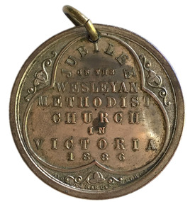
Badge - Jubilee of the Wesleyan Methodist Church Medal, 1886
In 1886 the Wesleyan Methodist Church celebrated the fiftieth jubilee of the establishment of the Wesleyan Methodist Association in Britain. The Association was one of several off-shoots of the Methodist Church, which had been established by John Wesley from the 1730s. Methodism stressed evangelism and a closer association with God. The focus on fiftieth anniversaries by the church originated in Leviticus 25:10: ‘And ye shall hallow the fiftieth year, and proclaim liberty throughout all the land unto all the inhabitants thereof: it shall be a jubilee unto you...’. In 1902 the various off-shoots of Methodism in Australia united to form the Methodist Church of Australasia. In 1977 the church became part of the Uniting Church. The Wesleyan Methodist Church which exists in Australia today is actually a branch of the Wesleyan Methodist Church of America, introduced to Australia during World War II. In 2003 it had almost 100 churches in Australia.Many of the early pioneers in the City of Moorabbin were Methodists.Silver Medal Side one: legend within trefoil; JUBILEE / OF THE / WESLEYAN / METHODIST / CHURCH / IN / VICTORIA / 1886 small floral decorations at each point of trefoil. Side two: Bust of John Wesleycity of moorabbin, wesleyan methodist church, religion, jubilee -
 Chiltern Athenaeum Trust
Domestic object, Stewart Dawson and Co, Unknown
Wilfred Clarence Busse was born in Chiltern, Victoria in 1898. His family first arrived in this region during the gold rush era, purchasing a piece of land adjacent to the Murray River. The spectacular scenery and rich history of the area is said to have inspired Busse in his writing. He attended Wesley College in his school days, before going on to study law at the University of Melbourne. After graduating from university, Busse would go on to become a barrister, but he is best known as a writer of fiction, publishing two novels: 'The Blue Beyond: A Romance of the Early Days in South Eastern Australia' and 'The Golden Plague: A Romance in the Early Fifties'. Busse died in 1960. This particular object was owned by Busse. It is a tie pin and, as inscribed on its box, it was manufactured by Stewart Dawson and Co, a successful jewellery company - founded in Sydney in the late nineteenth century - that is still active today. This object is significant as it was owned by Wilfred Clarence Busse, an accomplished barrister and writer from Chiltern, Victoria. It was also manufactured by Stewart Dawson and Co, a successful jewellery company, founded in the nineteenth century, that is still active today. A thin, curved, gold-coloured tie pin placed inside an open velvet-lined jewellery box. Inscribed beneath the lid are the words 'Stewart Dawson and Co. / Watch Manufacturers / and Jewellers / Sydney & London.Box open: Stewart Dawson and Co. / Watch Manufacturers / and Jewellers / Sydney & London w.c. busse, wilfred clarence busse, gold rush, gold rush chiltern, busse barrister, busse author, "the golden plague: a romance of the early fifties., "the golden plague”, "the blue beyond: a romance of the early days in south eastern australia", "the blue beyond", tie pin, jewellery, jewellery manufacturers, sydney jewellers nineteenth century, stewart dawson and co -
 Nillumbik Shire Council
Painting: David ARMFIELD (b.1923 Melb AUS - d. 2010 Melb AUS), David Armfield, Panton Hill, c.1980
David Armfield studied at the National Gallery School in the 1940s and turned to full time painting in 1965. RMIT printamking. He has won several art awards, including the Ramsay Prize - NGV School, the Redcliffe and in 1980 the Eltham Prize. Armfield is represented in the National Gallery collection, Art Gallery of NSW, Tasmanian Art Gallery, several regional art galleries across Australia as well as private collections. David Armfield first came to Eltham in the late 1903s on painting trips and used to camp on the banks of the Diamond Creed. He returned to Eltham in 1957 with his wife Joan who has subsequently become one of the district's potters, and built a mud brick house and studio in John Street on land adjoining Peter Glass. He has painted many landscapes in the district including intimate studies of the bush floor and the aftermath of bush fires.Oil on canvas painting depicting a Panton Hill bush scape.Signed: D. Armfield in lower right hand corner. Not dated.david armfield, eltham art prize, panton hill -
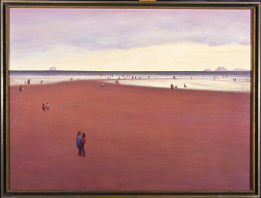 Nillumbik Shire Council
Painting: David ARMFIELD (b.1923 Melb AUS - d. 2010 Melb AUS), David Armfield, Untitled (Beach), c. 1975
David Armfield studied at the National Gallery School in the 1940s and turned to full time painting in 1965. RMIT printamking. He has won several art awards, including the Ramsay Prize - NGV School, the Redcliffe and in 1980 the Eltham Prize. Armfield is represented in the National Gallery collection, Art Gallery of NSW, Tasmanian Art Gallery, several regional art galleries across Australia as well as private collections. David Armfield first came to Eltham in the late 1903s on painting trips and used to camp on the banks of the Diamond Creed. He returned to Eltham in 1957 with his wife Joan who has subsequently become one of the district's potters, and built a mud brick house and studio in John Street on land adjoining Peter Glass. He has painted many landscapes in the district including intimate studies of the bush floor and the aftermath of bush fires.'Untitled' by David Armfield an oil on canvas painting depicts sand, sea, distant mountains and various figures scattered about in a typical Armfield landscape. The figures tend to be annonymous, sometimes included more to establish the scale than for a narrative purpose. The figures are well clothed and it could be assumed that it is not a hot summer's day. Depth is established by changing of colours and diminishing the size of the figures.david armfield, beach, eltham, nillumbik shire council -
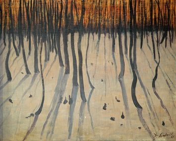 Nillumbik Shire Council
Painting: David ARMFIELD (b.1923 Melb AUS - d. 2010 Melb AUS), David Armfield, Eltham 1965, 195
David Armfield studied at the National Gallery School in the 1940s and turned to full time painting in 1965. RMIT printamking. He has won several art awards, including the Ramsay Prize - NGV School, the Redcliffe and in 1980 the Eltham Prize. Armfield is represented in the National Gallery collection, Art Gallery of NSW, Tasmanian Art Gallery, several regional art galleries across Australia as well as private collections. David Armfield first came to Eltham in the late 1903s on painting trips and used to camp on the banks of the Diamond Creed. He returned to Eltham in 1957 with his wife Joan who has subsequently become one of the district's potters, and built a mud brick house and studio in John Street on land adjoining Peter Glass. He has painted many landscapes in the district including intimate studies of the bush floor and the aftermath of bush fires. Painting: oil on canvas. Depicting the desolate aftermath of a bushfire in Eltham. Trees are bare and burnt, foreground is sparse, whilst background is fiery red.david armfield, eltham, bushfire -
 Nillumbik Shire Council
Ceramic (plate): Joan Armfield & David Armfield, David Armfield, Platter with dolomite glaze and Grevillia decoration, c.1975
David Armfield: David Armfield studied at the National Gallery School in the 1940s and turned to full time painting in 1965. RMIT printamking. He won several art awards, including the Ramsay Prize - NGV School, the Redcliffe and in 1980 the Eltham Prize. Armfield is represented in the National Gallery collection, Art Gallery of NSW, Tasmanian Art Gallery, several regional art galleries across Australia as well as private collections. David Armfield first came to Eltham in the late 1930s on painting trips and used to camp on the banks of Diamond Creed. He returned to Eltham in 1957 with his wife Joan who has subsequently become one of the district's potters, and built a mud brick house and studio in John Street on land adjoining Peter Glass. He has painted many landscapes in the district including intimate studies of the bush floor and the aftermath of bush fires.Ceramic stoneware. Reduction fired, dolomite glaze, wax resist decoration over iron. Decorated/painted by David Armfield. Cast by Joan Armfield. -
 Ballarat Heritage Services
Photograph - Photograph - Colour, Clare Gervasoni, Tarilta, 2017, 16/07/2017
Tarilta is a rural locality and former gold-mining town 12 km south of Castlemaine, 4 km north-west of Guildford and 3 km north-east of Vaughan. The last gold mining activity took place around the 1880s. It was originally Kangaroo Flat, being located where the Kangaroo Creek enters the Loddon River. It was surveyed and named in 1864. Gold was discovered at Tarilta in 1853. The Tarilta School was opened in 1860 in a Wesleyan chapel, and closed i n1925. In 1864 a township was surveyed and named Tarilta, the word being derived from an Aboriginal expression thought to mean kangaroo. In 1865 Bailliere’s Victorian gazetteer described Tarilta as being an alluvial and quartz gold-mining town with three quartz-crushing mills, three horse-puddling machines and two hotels. The elevated nature of the land around Tarilta made it accessible only by horse and dray, or on horseback. Colour photograph of Tarilta in Central Victoria. tarilta, central victoria, landcape -
 Mt Dandenong & District Historical Society Inc.
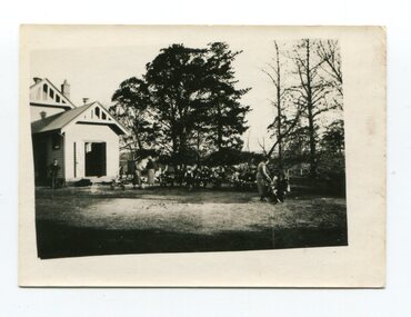
Photograph
William Dower came with his family to the Mt Dandenong in 1898, taking up a 10 acre allotment. William and his wife Elizabeth had seven boys (Will, Harry, Bert, Walter, Joe, Edgar, Robert) and four girls (Emmy, May, Ada, Ruby). The property secured by William Dower was known as ‘Cambridge Gardens’ and had a two room slab hut. William and his sons added another five rooms using trees from the property. The family established extensive crops and worked hard for their success. The acreage extended to 30 when the family bought up neighbouring properties. Standing on William Dower's land this mighty tree was 286 feet high to its broken top with a 66 feet girth. It took Wally and Bert Dower a week to grub out the tree and then another week for the wind to blow it down.Black and white photograph with a very tall dead tree in the centre. A group of people visible in the foregrounddower, william dower, tree, wally dower, bert dower -
 Bendigo Historical Society Inc.
Document - DAVID BANNEAR, THE GOLDFIELDS LANDSCAPE - PROPOSED TALK, 2/11/2023
The goldfields resulted in the almost complete denuding of trees for access to the gold bearing land, for firewood and for the tanning industry. The need for wood further increased with the advent of deep quartz mining that required timbers for shoring up the shafts and tunnels. At some point in time it became necessary for timber to be carted long distances to fulfil the need. Between 1878 and 1884, the government set up 5 nurseries to try and rectify the shortage of native softwoods and encouraged the growth of State plantations and the thinning of trees to encourage growth of those remaining. 1907 - Creswick School of Forestry and Forest Management was started 1919 Establishment of the Forests Commission and the planting of many pine plantations 1924 Establishment of the first fire spotting towers Forest management tasks became a main project for "Susso" recipients during the Great Depression and again for internees during WWII.An 8 page document by David Bannear about the various industries of the Bendigo Goldfields and their effects on terraforming the local environment david bannear, central goldfields -
 Bayside Gallery - Bayside City Council Art & Heritage Collection
Work on paper - ink and watercolour, Annette Meikle, Black Rock House, 1977
In 1977, artist Annette Meikle undertook a commission to illustrate a book recording stories of places and people in the Bayside area. It was published in 1978 as Sandringham Sketchbook, with text by Elizabeth Waters. The sketches were intended to record remaining examples of Bayside’s early architecture and environment, as well as reflect newer architectural changes. Meikle went on to donate 22 of these sketches to Bayside City Council in 2003. Black Rock House was built in 1858 by wealthy land dealer and politician Charles Hobson Ebden as a holiday home on 112 acres of virgin scrub, taking in the area of present day Balcombe Road, Beach Road and the line of Keating Street. The house included four bedrooms, a cellar, stables and a courtyard enclosed in castle-like sandstone walls. It was named Black Rock House after Black Rock Castle near Dublin, associated with Mrs Ebden’s childhood.Annette Meikle, Black Rock House 1977, ink and watercolour, 33 x 53.5 cm. Bayside City Council Art and Heritage Collection. Donated by the artist, 2003annette meikle, sandringham sketchbook, elizabeth waters, black rock house, black rock, charles hobson ebden, architecture, historic house -
 Kew Historical Society Inc
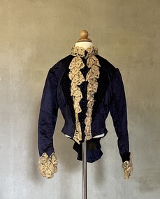
Clothing - Midnight blue silk and velvet bodice
This bodice, belonging to Alice (Henty) Hindson has traditionally been identified as a travelling jacket by her descendants. Alice Hindson was the youngest daughter of Francis Henty and Mary Ann (Lawrence) Henty. Alice's father, Francis Henty, was the youngest son of Thomas Henty, who with his family, their retainers and property moved to the Australian colonies between 1829 and 1832. In 1834, Francis’ older brother, Edward, sailed from Launceston in Van Diemen’s Land to what was to become Portland in the western part of Port Phillip District [Victoria]. Francis, together with the first flock of Merino sheep [in Victoria], followed some months later. The first and second generations of the Henty family established vast pastoral properties in the Western part of the Port Phillip District. Francis Henty managed ‘Merino Downs’ near Casterton, while also living in his retirement at ‘Field Place' in Kew. The Henty Collection of nineteenth and twentieth century clothing, including outerwear and underwear, was collected, stored and exhibited over time by female family members descended from Francis and Mary Ann Henty. During the twentieth century, items from the collection were modelled in two fashion parades by various descendants [1937, 1959]. The items in the collection are historically and aesthetically significant, with provenance provided by oral and written tradition within or held by the family. A number of the items in the collection are very rare survivors, and provide researchers with the evidence needed to reconstruct the lives of notable women in the Port Phillip District [later Victoria] during the nineteenth and early twentieth century.Alice (Henty) Hindson's midnight blue sateen bodice is highlighted using velvet lapels, cuffs, and a rear bow. The velvet, in contrast to the plain midnight blue sateen, is embellished [in the weave] with pink and navy spots. Joined at the front with 23 round domed buttons, hooks and eyes are used to close the neckline. The bodice also features coffee-coloured lace at the front and on the cuffs, which may have been added later. The bodice has some condition issues, missing one cuff and the lace on the cuffs needing re-attaching. The inside of the bodice is heavily boned, complete with a floral chintz lining. Measurements (mm): BODICE: Girth - Neck 355.6, Chest 812.8, Waist 660.4, Hip 685.8, Cuff 228.6 Vertical - From neck to hem 406.4, Front waist to hem 152.4, Back neck to hem 546.1, Back waist to hem 228.6, Sleeve length 533.4. Horizontal - Neck to sleeve head 114.3, Cross back 266.7, Underarm to underarm 368.3.alice hindson, alice henty, bodices, women's clothing, alice (henty) hindson -
 Surrey Hills Historical Society Collection
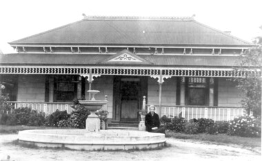
Photo, 'Spenceycroft', Canterbury Road
The photo is of ‘Spenceycroft’ at 654 Canterbury Road, Surrey Hills. For many years this home was hidden behind a large fence sheltering it from the noise of traffic along Canterbury Road, however it dates back to the very early days of settlement in the Surrey Hills area. Canterbury Road was then known as Delany’s Road. ‘Spenceycroft’ is thought to incorporate part of the original farmhouse built on the site by George Klepper, who planted a vineyard in the area. George’s family was one of a number of German families who settled in Surrey Hills during the later part of the 19th century. Later, the land associated with ‘Spenceycroft’ was worked as a dairy farm by James and Elizabeth Rayment. In recent years 'Spenceycroft' has been sold several times and has become increasingly derelict. Sold again in 2015 when it had become quite derelict, it was demolished and re-developed.A black & white photo of double-fronted Victorian style home with a fountain centre front and low foliage in front of the veranda. A woman is sitting by the fountain. 'spenceycroft', canterbury road, james rayment, elizabeth rayment, george klepper -
 Surrey Hills Historical Society Collection
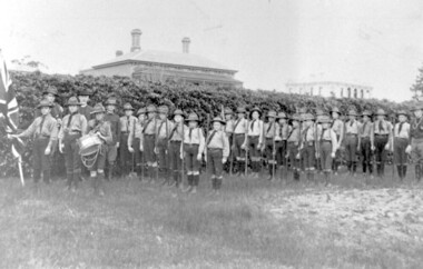
Photograph, 1st Surrey Hills Boy Scout Troop c. 1909-1912
1st Surrey Hills Boy Scout Troop was formed in 1909 by Theodore Hendy, two years after Lord Robert Baden-Powell had started the Movement. Hendy (left back) sent Baden-Powell greetings advising he was sending a photo of his troop. This could be the photograph. Taken in the grounds of his home "Kookaburra" (demolished) in Albany Crescent, Surrey Hills (later given the number 44). The Royal Hotel on the corner of Canterbury Road and Broughton Road can be seen on the right. The photograph was taken by M. Hill, uncle of Mr W. Dempsey. 'Kookaburra' was the home of Theodore Hendy's uncle Archibald Noete Hendy, an estate agent. Earlier it was known as 'Glastonbury'. In c1938 the house was demolished and the land divided into 4 lots. Archibald Hendy and his wife Bertha Bowen (nee Rohs) later resided at 'Barehin' in Pembroke Street. Black & white photo of 1st Surrey Hills Boy Scout Troop in the grounds of 'Kookaburra' (now demolished) in Albany Crescent Surrey Hills. In the background are 2 buildings. surrey hills scout troop, 1900-1909, 1910-1919, royal hotel, albany crescent, surrey hills, uniforms, hats, flags, clothing and dress, canterbury road, broughton road, house names, hotels, scout groups, youth clubs, (mr) w dempsey, (mr) m hill, (mr) theodore hendy, 'kookaburra'