Showing 30632 items
matching hill
-
 Surrey Hills Historical Society Collection
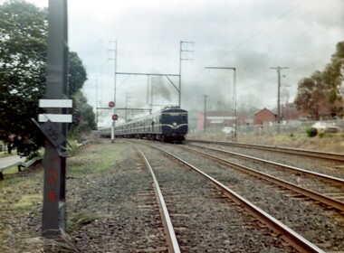
Photograph, A blue Harris electric train heads towards Union Road, Surrey Hills
The Harris blue electric trains were introduced in c1955 and followed the 'Red Rattlers'. They had a long life and were named after Norman Charles Harris, Chairman of Commissioners of the Victorian Railways, between 1940 and 1950. The first 30 7-carriage trains, known as the first series, were constructed in the United Kingdom by Gloucester Railway Carriage and Wagon Company, and delivered between 1956 and 1959. Another 30, the second series, were built by Martin & King in Melbourne, and delivered between 1961 and 1967. The trains had either two or three sets of hand-operated dual sliding doors per carriage side. Later they were fitted with power doors. Initially, until late 1978, the interiors were split into smoking and no-smoking compartments. In 1978 smoking on trains was abolished. Carriages were also designated as First or Second class until 1958, when one class travel was introduced. they had florescent lights but no heating. Most of the early carriages did not have end doors and gangways between carriages, but safety concerns led these being incorporated in the sets delivered from mid-1966. With the exceptions of the last few carriages built, all Harris trains contained asbestos insulation. The first sets contained blue asbestos, and the later sets contained white asbestos in the linings for insulation of noise and temperature. Due to the presence of asbestos, they began to be withdrawn from the mid-1980s and most were disposed of in the 1990s, by being buried at Talbot Quarry in Clayton, some having been wrapped in plastic. No original Harris trailer cars remain. A coloured photograph of a blue Harris electric train heading towards Surrey Hills station from Mont Albert station. The electricity sub-station and Lorne Parade are on the RHS of the photo and Beresford Street on the LHS. The grey, smoggy appearance of the sky suggests a winter's morning.surrey hills, trains, lorne parade, beresford street, norman charles harris, gloucester railway carriage and wagon company, martin & king, talbot quarry, harris blue train -
 Lakes Entrance Historical Society
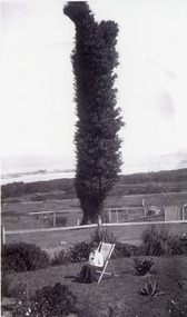
Photograph, 1920c
Black and white photograph of The Tree on Merrangbaur Hill. This dead iron bark tree covered with vine, was for many years a landmark for vessels at sea. View of sand hummocks and Cunninghame Arm in background. Lady seated on deckchair in Merrangbaur House garden, Lakes Entrance Victoria.guesthouses, topography, coast, local history -
 Lakes Entrance Historical Society
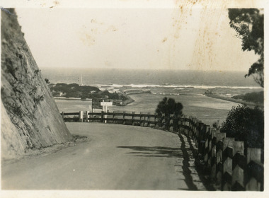
Postcard - The Entrance, Bulmer H.D, 1940c
Black and white small format postcard showing a bend in the Princes Highway on the Kalimna Hill. The road runs between the steep road cutting and post and rail guard fence. The artificial entrance from Bass Strait to Lakes system is in view. Lakes Entrance Victoriawaterways, islands -
 Linton and District Historical Society Inc
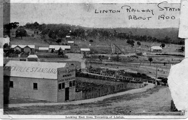
Photograph, Grenville Standard and Linton Railway Station buildings, c.1900
The 'Grenville Standard' was Linton's newspaper from 1895-1941. The railway arrived at Linton in 1891. Black and white postcard photograph of view looking east from Clyde Street in Linton township. 'Grenville Standard' building prominent in foreground, railway buildings and machinery, and station-master's house, in middle ground. Hills rising behind, with two or three cottages, and trees."Linton Railway station about 1900" hand printed across top of photograph. "Looking East from Township of Linton" printed beneath picture.grenville standard [newspaper], linton railway station, buildings, station master's house linton -
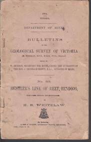 Bendigo Historical Society Inc.
Book - STRUGNELL COLLECTION: DEPARTMENT OF MINES: 1914 GEOLOGICAL SURVEY OF VICTORIA. HUSTLERS LINE OF REEF, 1914
Book, Department of Mines, Bulletins of the Geological Survey of Victoria, No.33, Hustler's Line Of Reef, Bendigo, with plans,sections, and photographs, by H.S.Whitelaw. 13833, Price 2s.6d.`Back cover shows J.A. and J.A Strugnell , 12 Mulbar St Swan Hill 3585 .Albert J. Mullett, Government Printer, Melbourne.book, bendigo, hustler's line of reef -
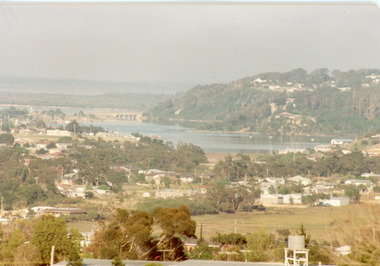 Lakes Entrance Historical Society
Photograph - Township, Fish, Marie, 1985c
Colour photograph of part of township showing Jemmys Point, Mount Barkly, Kalimna Heights, North Arm & old North Arm bridge, looking beyond to Rigby Island. Photo taken from near Telecom Tower on Merrangbaur Hill. Lakes Entrance Victoriatopography, township, waterways, bridges -
 National Vietnam Veterans Museum (NVVM)
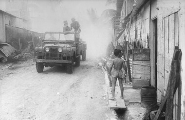
Photograph, Gibbons, Denis, Dengue Fever Outbreak
Denis Gibbons (1937 – 2011) Trained with the Australian Army, before travelling to Vietnam in January 1966, Denis stayed with the 1st Australian Task Force in Nui Dat working as a photographer. For almost five years Gibbons toured with nine Australian infantry battalions, posting compelling war images from within many combat zones before being flown out in late November 1970 after sustaining injuries. The images held within the National Vietnam Veterans Museum make up the Gibbons Collection. A black and white photograph of Lt Phil Hills, Liverpool, NSW, Officer Commanding the 1st Australian Field Hygiene Unit discusses his tactics with an Australian Task Force Intelligence Officer at Long Dien Village, Phuoc Tuy, during an outbreak of Dengue Fever. photograph, lt phil hills, 1st australian field hygiene unit, phuoc tuy, long dien village, dengue fever, gibbons collection catalogue, vietnamese children, australian task force, phuoc tuy, denis gibbons -
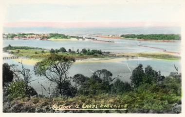 Lakes Entrance Historical Society
Postcard - Bullock Island, Bulmer H D, 1920c
Hand coloured postcard of Bullock Island and the man made entrance from Bass Strait to the Gippsland Lakes. Also shown the small township, unofficially known as Carpentertown at the entrance works. Photo taken from Kalimna Hill, shrubbery in foreground. Lakes Entrance VictoriaBullock Island, Lakes Entrancewaterways, bridges, islands, jetties -
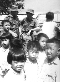
 National Vietnam Veterans Museum (NVVM)
Photograph, Gibbons, Denis, Dengue Fever
Denis Gibbons (1937 – 2011) Trained with the Australian Army, before travelling to Vietnam in January 1966, Denis stayed with the 1st Australian Task Force in Nui Dat working as a photographer. For almost five years Gibbons toured with nine Australian infantry battalions, posting compelling war images from within many combat zones before being flown out in late November 1970 after sustaining injuries. The images held within the National Vietnam Veterans Museum make up the Gibbons Collection. A black and white photograph of Lt Phil Hills and his team driving a landrover towing a mist generator to decontaminate the village of Long Dien, Phouc Tuy Province. A severe outbreak of Dengue Fever had occurred in the village and the Province Chief had requested assistance.photograph, lt phil hills, 1st australian field hygiene unit, long dien village, phuoc tuy province, dengue fever, gibbons collection catalogue, denis gibbons, photographer, vietnam war, province chief -
 Melbourne Tram Museum
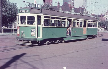
Slide, Keith Caldwell, 12/03/1960 12:00:00 AM
Agfa Colour slide, cardboard mount, by Keith Caldwell of 12 March 1960 - of SW6 875 at junction with Victoria Parade and Brunswick St (now St Vincent's Plaza) wit the Eastern Hill fire station in the background. Tram has adverts for Radio 3AW and ?.1 - hand stamped "12 Mar '60"trams, tramways, st vincent's plaza, victoria parade, west preston, route 10, sw6 class, tram 875 -
 Melbourne Tram Museum
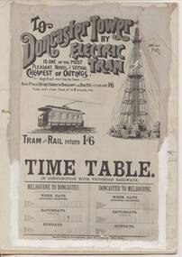
Poster - Illustration/s, Tramway Museum Society of Victoria (TMSV), 1960's?
Black and white Illustration of the Doncaster - Box Hill tramway used for printing purposes. Has been adhered to a piece of cardboard with "whiteout" surrounding the edges to hide the edges. See also Reg Item 198 for a colour reproduction of this poster and Reg Item for a framed print.On the rear is the "The Tramway Museum Society of Victoria Limited" stamp.trams, tramways, box hill, timetables, doncaster -
 Lakes Entrance Historical Society
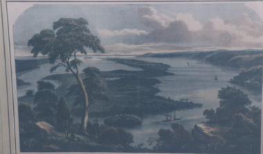
Photograph - Jemmys Point Lakes Entrance, 1880 c
Colour photograph print of early painting of view from Jemmys Point towards Metung showing paddle steamer and Aboriginals in bottom left hand corner Rigby Fraser and Flannagan Islands centre of painting, The Barrier on the left Nungurner Hills on right Gippsland LakesEntrance to The Gippsland Lakesaerial photograph, township, topography, jemmys point lakes entrance -
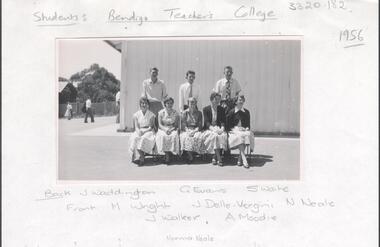 Bendigo Historical Society Inc.
Photograph - LA TROBE UNIVERSITY BENDIGO COLLECTION: BENDIGO TEACHERS' COLLEGE STUDENTS
A black and white photograph of Bendigo Teachers' College students in 1956 in front of the Camp Hill State School portable classroom. They are J. Waddington, G. Evans, S. Waite, M.Wright, J. Della-Vergini, N. Neale, J. Walker and A. Moodie. See 3320.100bendigo, education, bendigo teachers' college students, la trobe university bendigo collection, collection, bendigo, education, tertiary education, teacher training, bendigo teachers' college, students, photo, photos, photograph, photographs, miss j.c. burnett, mr. geoff pryor, history -
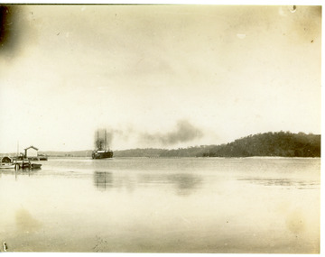 Lakes Entrance Historical Society
Photograph - SS Wyrallah, Phillips, Miss L, c1910
Sepia photograph showing steamer entering the Gippsland Lakes. Jetties on left - white shed on New Works jetty. Jemmy's Point, Mt Barkly on right, Kalimna and Nungurner Hills in background. Steamer SS Wyrallah coming into Cunninghame Arm. Lakes Entrance VictoriaComing in the Entrance (on back)waterways, ships and shipping -
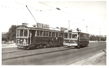 Bendigo Historical Society Inc.
Photograph - BASIL MILLER COLLECTION: TRAMS - BENDIGO TRAMWAYS
BHS CollectionTwo trams, side by side. No. 2 and 30. C 1964. Larger tram on left hand side of image has 'Quarry Hill' on front. Advertising sign on side 'Electric Cooking, Matchless'. Smaller tram on right hand side has 'special' on front. '3/64' on rear side of photo.basil miller, bendigo tramways, quarry hill tram -
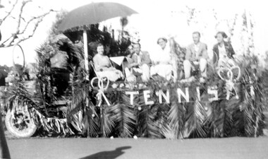 Surrey Hills Historical Society Collection
Photograph, Tennis club float for Empire Day celebrations, circa 1935, c1935
The donor, Jean Boucher was the daughter of Wally Ives and she was an early active member of the History Nook at the Surrey Hills Neighbourhood Centre and the Surrey Hills Historical Society. The Ives family were associated with the Wyclif Church Tennis Club, so this is possibly the Wyclif float.Black and white photo of a float created on the tray of a truck for the Empire Day celebrations in 1935 or 1936. The side of the truck and the cabin are decorated in palm leaves and 2 sets of crossed tennis racquets and the word 'tennis' appear on the side of the tray. On the tray there are 2 men and 3 women seated in a casual setting, some under an umbrella. tennis, sports, empire day, parades and processions, wyclif church, (miss) jean ives, (mrs) jean boucher -
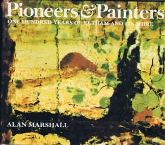 Greensborough Historical Society
Book, Alan Marshall, Pioneers & painters: one hundred years of Eltham and its Shire, 1971
Alan Marshall describes the early European history of the Shire of Eltham, from the first settlers in the area to the painters who have made it their home. Covers Kangaroo Ground, Queenstown, Panton Hill, Christmas Hills, Eltham, Kinglake, Hurstbridge, Warrandyte, Montmorency and Lower Plenty.144 p., illus. (some col.).alan marshall, local history, shire of eltham -
 Victorian Interpretive Projects Inc.
Photograph - Black and White, Ballarat, c1854
The town you see had over 50,000 people. Bridge Street on the left is well established. The crude pans and cradles of the early “diggers’ were already giving way to steam power and the deep shafts of the “miners”. Money and machinery were needed to get to the deeper leads, and the smoke stacks of the great company mines can be seen across the photo.Four black and white photographs placed together to make a panorama of Ballarat looking towards Mt Warrenheip. On the left the chimney and gasometer indicate the corner of Dana Street and Albert Street. This is now the Ballarat Law Courts. The photograph is behind glass in a black frame. These four photographs were taken from the slope of the Ballarat School of Mines where the Uniting Church now stands. When joined they give a panoramic view of one of the world’s richest alluvial goldfields. The Waterloo Mine was one of the first deep shafts and was sunk at the foot of the Dana Street hill. Its tailings are seen in the second photo from left. The following was typed and placed with the framed image. Ballarat Circa 1858 This is the most significant of the photographs of early Ballarat. The photographer stood on the slope near S.M.B. where the Wesley Church now stands and took four pictures. When joined them have this panoramic view of one of the world's richest alluvial goldfields. Seven years earlier this landscape was empty. The town you see had over 50,000 people. Bridge Street on the left is well established the Ballarat gas Company stands on the same place as today. The crude pans and cradles of the early "diggers" were already giving way to steam power and the deep shafts of the :"miners". Money and machinery were needed to get to the deeper leads, and the smoke stacks of the great company mines can be seen across the photo. The Waterloo mines was one of the first deep shafts and was sunk at the foot of the Dana Street hill. Its tailings are seen in the second photo from the left. ballarat, ballarat townscape, panorama, waterloo mine -
 Ballarat Heritage Services
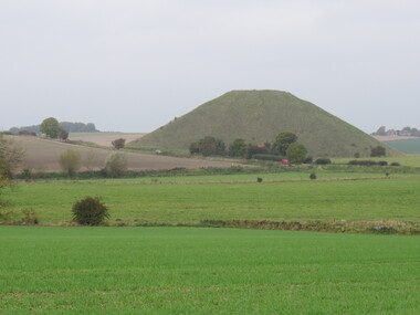
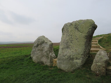
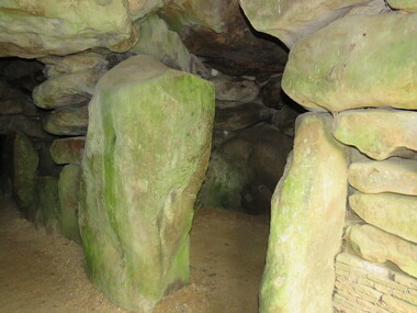
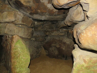
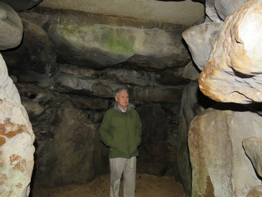
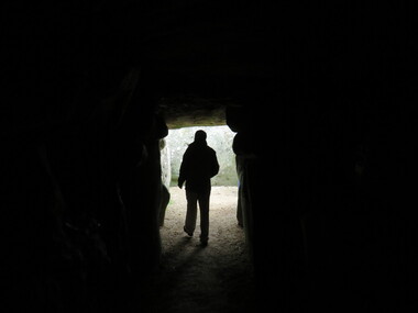
Photograph - Colour, Avebury World Heritage Site, Prehistoric Monuments, England, 2016
Colour photograph of the Silbury Hill, an immense Neolithic man-made mound part of the Avebury World Heritage Site. The Avebury World Heritage Site is a complex of outstanding prehistoric monuments comprising Windmill Hill (Early Neolithic enclosure and Bronze Age burial mounds); Silbury Hill; West Kennet Long Barrow; Avebury Stone Circles and West Kennet Avenue; The Sanctuary (site of stone and timber circles). It is part of National Trust and English Heritage. Visitors may walk to sites.avebury world heritage site, mound, prehistoric monuments, silbury hill, west kennet long barrow, neolithic, world heritage -
 Ballarat Heritage Services
Photograph - Colour, Avebury World Heritage Site, Prehistoric Monuments, England, 2016
Colour photograph of the Silbury Hill, an immense Neolithic man-made mound part of the Avebury World Heritage Site. The Avebury World Heritage Site is a complex of outstanding prehistoric monuments comprising Windmill Hill (Early Neolithic enclosure and Bronze Age burial mounds); Silbury Hill; West Kennet Long Barrow; Avebury Stone Circles and West Kennet Avenue; The Sanctuary (site of stone and timber circles). It is part of National Trust and English Heritage. Visitors may walk to sites.Colour photograph of Avebury World Heritage Stte.avebury world heritage site, prehistoric monuments, rocks -
 Ballarat Heritage Services
Photograph - Colour, Avebury World Heritage Site, Prehistoric Monuments, England, 2016
Colour photograph of the Silbury Hill, an immense Neolithic man-made mound part of the Avebury World Heritage Site. The Avebury World Heritage Site is a complex of outstanding prehistoric monuments comprising Windmill Hill (Early Neolithic enclosure and Bronze Age burial mounds); Silbury Hill; West Kennet Long Barrow; Avebury Stone Circles and West Kennet Avenue; The Sanctuary (site of stone and timber circles). It is part of National Trust and English Heritage. Visitors may walk to sites.Colour photograph of Avebury World Heritage Site. avebury world heritage site, prehistoric monuments, rocks -
 Ballarat Heritage Services
Photograph - Colour, Avebury World Heritage Site, Prehistoric Monuments, England, 2016
Colour photograph of the Silbury Hill, an immense Neolithic man-made mound part of the Avebury World Heritage Site. The Avebury World Heritage Site is a complex of outstanding prehistoric monuments comprising Windmill Hill (Early Neolithic enclosure and Bronze Age burial mounds); Silbury Hill; West Kennet Long Barrow; Avebury Stone Circles and West Kennet Avenue; The Sanctuary (site of stone and timber circles). It is part of National Trust and English Heritage. Visitors may walk to sites.Colour photograph of Avebury World Heritage Site.avebury world heritage site, rocks, prehistoric monuments -
 Ballarat Heritage Services
Photograph - Colour, Wayne Phillipson, Avebury World Heritage Site, Prehistoric Monuments, England, 2016
Colour photograph of the Silbury Hill, an immense Neolithic man-made mound part of the Avebury World Heritage Site. The Avebury World Heritage Site is a complex of outstanding prehistoric monuments comprising Windmill Hill (Early Neolithic enclosure and Bronze Age burial mounds); Silbury Hill; West Kennet Long Barrow; Avebury Stone Circles and West Kennet Avenue; The Sanctuary (site of stone and timber circles). It is part of National Trust and English Heritage. Visitors may walk to sites.Colour photograph of the Avebury World Heritage Site.prehistoric monuments, avebury world heritage site, rocks -
 Ballarat Heritage Services
Photograph - Colour, Wayne Phillipson, Avebury World Heritage Site, Prehistoric Monuments, England, 2016
Colour photograph of the Silbury Hill, an immense Neolithic man-made mound part of the Avebury World Heritage Site. The Avebury World Heritage Site is a complex of outstanding prehistoric monuments comprising Windmill Hill (Early Neolithic enclosure and Bronze Age burial mounds); Silbury Hill; West Kennet Long Barrow; Avebury Stone Circles and West Kennet Avenue; The Sanctuary (site of stone and timber circles). It is part of National Trust and English Heritage. Visitors may walk to sites.Colour photograph of Avebury World Heritage Site. avebury world heritage site, prehistoric monuments, rocks -
 Surrey Hills Historical Society Collection
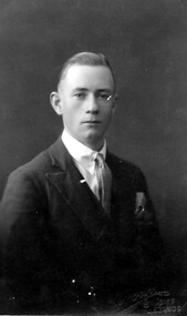
Photograph, Jack Sneddon
John William (Jack) was the son of William and Mary Sneddon and brother of Alan. William Sneddon was a postman in Surrey Hills for many years. His father James ran an estate agency in Surrey Hills established by his father in the 1880s. William's wife was Mary Sneddon (nee Bird). Jack was born in 1908 in Camberwell. In 1937 his address was 19 Albert Street, Surrey Hills. The donor Robin da Costa-Adams is related to the Sneddon family through her first marriage.Formal sepia head and shoulders photo of Jack Sneddon dressed in a suit and tie. 'Crown/ Studios/ Melbourne' impressed on original in lower RH corner.jack sneddon, john william sneddon, (miss) mary bird, (mrs) mary sneddon, james sneddon, crown studios -
Eltham District Historical Society Inc
Document - Folder, Motschall, Emil and Marjorie Florence Smith
Emil William (Mon) Motschall lived at Panton Hill all his life and married Marjorie Smith, also a local. In 1969, he was awarded the British Empire Medal for services to the local Fire Brigade and was involved with other local organisations. Marjorie wrote two chapters in Alan Marshall's book "Pioneers and Painters" and wrote a history of Panton Hill. Contents Newspaper article: "Mon devoted a life to the Hill", Diamond Valley News, c1977, Life of Emil Motschall. Newspaper article: "Book on 'Hill' is launched", Diamond Valley News, 20 March 1984. Launch, by Robert Marshall, of Marjorie Smith Motschall's book "Wild Wood Days at Panton Hill". Newspaper article: "Rare welcome for visitors to craftschop", Diamond Valley News, 20 March 1984. Small drama of locked door at Montsalvat craftschop. Newspaper article: "Marjorie Florence Smith Motschall". Obituary. Newspaper death notices: Marjorie Motschall.Newspaper clippings, A4 photocopies, etcemile william (mon) motschall, panton hill vic, panton hill fire brigade, british empire medal, marjorie florence smith motschall, albert motschall, arthur cracknell, edwin smith, violet smith, long gully road panton hill, wild wood days at panton hill, robert marshall, alan marshall, "pioneers and painters", reverend peter lawry, montsalvat, evie gough, susan gough, william motschall, rosemary motschall, marjorie anne motschall -
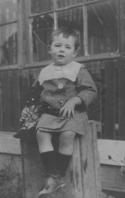 Surrey Hills Historical Society Collection
Digital photo, Alan Holt as an infant, c1914
Alan Judge Holt as an infant. He was born 16 June 1912, one of 3 sons of Edmund Holt and his wife Ruby Ellen Sutton. His brothers were Frederick Sutton Holt (1914-1992) and Raymond James Holt (1918-2000). The family home was 9 Beatrice Avenue, Surrey Hills and the family were active members of the Surrey Hills Methodist Church. Alan married Edna Jean Pallot in 1937 and they too had 3 sons - Barry, Neville and Max. Alan and Edna and family lived at 62 Broughton Road, Surrey Hills; later Alan and Edna lived at 2 Earle Street, Mont Albert and finally 13 Berry Street, Box Hill. Alan became Secretary of the Victorian Lands Department. He was passionate about local history and was responsible for much of the backbone research and records of the Surrey Hills local history collection. He died in 1993.A young Alan Judge Holt sitting on a box. Estimated age is 2 years.alan holt, alan judge holt, infants -
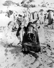 Surrey Hills Historical Society Collection
Photograph, Stalker family beach picnic, 1930s
Associated with the Stalker family of Surrey Hills. Betty Neil Smith (Stalker) was born in 1919 in Balwyn (Surrey Hills). She was one of 4 daughters of Alexander MacLaren Stalker (1885-1970/1973) and Charlotte Eleanor Hayward (1884-1953) who were married in 1911. Her sisters were Ruth McLaren Stalker (1913, Surrey Hills), Joan Winnock Stalker (1917, Surrey Hills) and Beatrice Mary Stalker(1919). Their mother Charlotte Hayward was a teacher prior to her marriage. Their father Alexander, an accountant, lived in Wattle Valley Road, Canterbury in 1910. From 1912-1931 they are listed at ‘Benwerrin’, (44) Wandsworth Road, Surrey Hills. This was later the home of Beatrice Mary and Howard Everard. Betty, Ruth and Joan later lived at 9/48 Wandsworth Road. it is assumed that the photo is of the Stalker girls and given their parents' later residence at Brighton, this may have been taken at Brighton beach. This photo documents part of the social history of a family with a long and strong association with Surrey Hills. The backdrop of the typical bathing boxes used for changing into swimsuits, for lunch and for storing sports and beach gear, documents beach recreation and culture of the 1930s. For many years in the late nineteenth century, Brighton was Melbourne's favourite seaside destination. The now iconic bathing boxes were a response to Victorian ideas of morality and sea bathing. There are 82 Brighton bathing boxes, which protected by a heritage overlay because of their uniform scale and proportion, building materials, sentry order alignment. All retain their classic Victorian architectural features with timber framing, weatherboards and corrugated iron roofs. They remain as they did over one hundred years ago, as licensed bathing boxes. Service amenities such as electricity or water were never connected.A black and white photograph of many people enjoying the beach. There are bathing boxes in the background and some ti-tree beyond that.uniforms, clothing and dress, bathing boxes, stalker family -
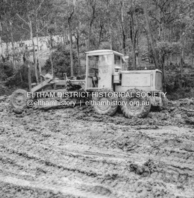 Eltham District Historical Society Inc
Album - Photograph, J.A. McDonald, Eltham-Yarra Glen Road, 3 Aug. 1956
Reconstruction Christmas Hills Showing Caterpillar bogged – 3/8/1956Record of various Shire of Eltham infrastructure works undertaken during the period of 1952-1962 involving bridge and road reconstruction projects, sometimes with Eltham Shire Council Project Reference numbers quoted. It was during this period that a number of significant improvements were made to roads and new bridges constructed within the shire that remain in place as of present day (2022). In many situations, the photos provide a tangible visible record of infrastructure that existed throughout the early days of the Shire. The album was put together by or under the direction of the Shire Engineer, J.A. McDonald.infrastructure, road construction, shire of eltham, bridge construction, eltham-yarra glen road, 1956-08-03, caterpillar, christmas hills, graders -
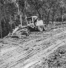 Eltham District Historical Society Inc
Album - Photograph, J.A. McDonald, Eltham-Yarra Glen Road, 3 Aug. 1956
Reconstruction Christmas Hills Showing Caterpillar bogged – 3/8/1956Record of various Shire of Eltham infrastructure works undertaken during the period of 1952-1962 involving bridge and road reconstruction projects, sometimes with Eltham Shire Council Project Reference numbers quoted. It was during this period that a number of significant improvements were made to roads and new bridges constructed within the shire that remain in place as of present day (2022). In many situations, the photos provide a tangible visible record of infrastructure that existed throughout the early days of the Shire. The album was put together by or under the direction of the Shire Engineer, J.A. McDonald.infrastructure, road construction, shire of eltham, bridge construction, eltham-yarra glen road, 1956-08-03, caterpillar, christmas hills, graders