Showing 11035 items matching " land"
-
 Kew Historical Society Inc
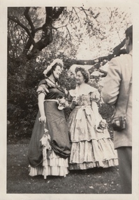
Photograph, The "Q" Theatre Guild, Blossom Time, 1958
The "Q" Theatre Guild was formed out of the Kew Light Opera Company in 1957. It marked the transition of the company that had initially been directed by Lance Nicholls to one directed by Beatrice Oakley. It continued to perform in the Kew Recreation Hall, but, with its demolition in 1960, and the opening of the new Kew City Hall in Cotham Road, moved its productions to that venue. Productions of the "Q" Theatre Guild included The Geisha (1957), Maritana (1958), They All Do It (1959), Blossom Time (1959), Love's A Luxury (1959), There And Back & The Bohemian Girl (1960), Die Fledermaus (1960), Gay Rosalinda (1961), The Land Of Smiles (1961), Kisses For A Kid & Hansel And Gretel (1961), Die Fledermaus (1962), Monsieur Beaucaire (1964), Macbeath or The Beggar's Opera, and So To Bed.The scrapbook of annotated photographs, programmes, and newspaper reviews of which this item is a part was assembled by Marion Tilley, wardrobe mistress for, and performer in, productions by the Kew Light Opera Company and the "Q" Theatre Guild. It is significant as a remarkably complete document of theatre performances in Kew, Victoria during the 1950s and 1960s. The scrapbook, and the items individually catalogued within it, have artistic and aesthetic significance within the history of performing arts in Victoria in the middle of the 20th Century. They have social significance in that they reveal socio-cultural values and preoccupations during the period. The records also act as a history of arts activities in the Kew Recreation Hall and later in the Kew City Hall as entertainment and community arts and music precincts.Faded photograph of Esme Melville and Jeanette Rayment in full costume in the Royal Botanical Gardens to promote The "Q" Theatre Guild's performances of Blossom Time during the Moomba Festival of 1959. The performances took place in the Alexandra Gardens. In the production, Melville performed the role of Countess Fritzi Frangipani, while Rayment played the role of Therese.Marion Tilley, the creator of the scrapbook, wrote the following underneath the photograph: "Esme Melville, Jeanette Rayment, Botanical Gardens, *** Blossom Time."performing arts -- kew (vic.), scrapbooks, marion tilley collection, 'q' theatre guild, kew recreation hall, musical comedy -- melbourne -- victoria -
 Kew Historical Society Inc
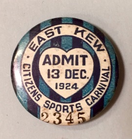
Badge - Fundraising Button, East Kew Citizens Sports Carnival: Admit 13 Dec. 1924, 1924
Most of the ephemera assembled by Francis Rigg were patriotic buttons but also included come sporting event buttons including two associated with the East Kew Citizens Sports Carnival. The subdivision of the area now known as Kew East commenced before World War 1, but it was not until the 1920s that it became fully developed. At this time, there was a strong Progress Association and this body raised funds to purchase land and build the East Kew Citizen’s Hall in Normandy Road, the first stage of which was completed in 1922. This hall was designed to be extended, although this never occurred, and the building now forms part of the facilities of the East Kew Uniting Church. The ‘East Kew Citizens Sports Carnival’ may well have been a fundraiser event for the building fund. As far as is known, the carnival was only held for a couple of years.Frances Rigg was a local business identity in Kew, at one stage managing the local branch of the English, Scottish and Australian (ES&A) Bank at 175 High Street from c. 1920 until the 1940s. After Francis Rigg’s death, the collection of buttons and medallions was inherited by his son, Ken Rigg (1922-2014). The collection was subsequently donated to the Kew Historical Society in 2015 by Francis' grandson, Adrian Rigg, at the time of the Gallipoli & Beyond Commemoration in 2015. The collection covers a period of almost 40 years. The majority of the buttons are patriotic buttons, issued and sold during and immediately after the First World World War (1914-1918) to raise funds for national and overseas causes. The collection also includes a number of locally significant sporting event buttons and sporting club medallions, issued in the 1920s and 1930s.A circular badge produced for the East Kew Citizens Sports Carnival in 1924. The badge has a ground of vertical stripes in shades of blue. The name of the event is within a white circular band. A white shield in the centre includes the words “Admit” which would indicate that the badge was purchased and worn on the day of the carnival to indicate that the wearer had paid the admission fee."East Kew Citizens Sports Carnival / Admit 13 Dec. 1924"kew east, sport buttons -
 Kew Historical Society Inc
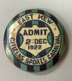
Badge - Fundraising Button, East Kew Citizens Sports Carnival, Admit 2nd December 1922, 1922
Most of the ephemera assembled by Francis Rigg were patriotic buttons but also included come sporting event buttons including two associated with the East Kew Citizens Sports Carnival. The subdivision of the area now known as Kew East commenced before World War 1, but it was not until the 1920s that it became fully developed. At this time, there was a strong Progress Association and this body raised funds to purchase land and build the East Kew Citizen’s Hall in Normandy Road, the first stage of which was completed in 1922. This hall was designed to be extended, although this never occurred, and the building now forms part of the facilities of the East Kew Uniting Church. The ‘East Kew Citizens Sports Carnival’ may well have been a fundraiser event for the building fund. As far as is known, the carnival was only held for a couple of years.Frances Rigg was a local business identity in Kew, at one stage managing the local branch of the English, Scottish and Australian (ES&A) Bank at 175 High Street from c. 1920 until the 1940s. After Francis Rigg’s death, the collection of buttons and medallions was inherited by his son, Ken Rigg (1922-2014). The collection was subsequently donated to the Kew Historical Society in 2015 by Francis' grandson, Adrian Rigg, at the time of the Gallipoli & Beyond Commemoration in 2015. The collection covers a period of almost 40 years. The majority of the buttons are patriotic buttons, issued and sold during and immediately after the First World World War (1914-1918) to raise funds for national and overseas causes. The collection also includes a number of locally significant sporting event buttons and sporting club medallions, issued in the 1920s and 1930s.A circular button produced for the East Kew Citizens Sports Carnival in 1922. The button has a ground of vertical stripes in shades of blue. The name of the event is within a white circular band. A white shield in the centre that includes the words “Admit” would indicate that the badge was purchased and worn on the day of the carnival to indicate that the wearer had paid the admission fee. "East Kew Citizens Sports Carnival, Admit 2nd December 1922"east kew, east kew citizens sports carnival, sports, badge, numismatics, francis rigg -
 Kew Historical Society Inc
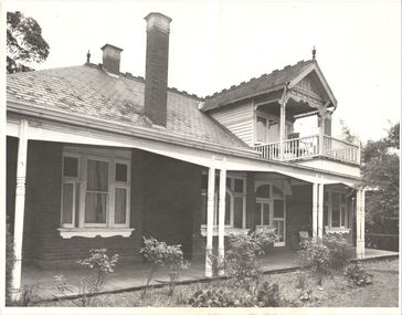
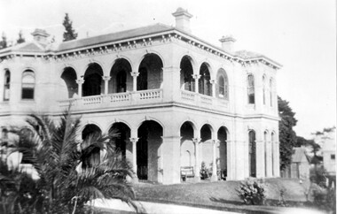
Photograph, Willsmere, circa 1965, c. 1965
The historian Dorothy Rogers records (A History of Kew, p.5) that "In 1888 he [Arthur Wills] took over his estate, 'Willsmere', and conducted it as a dairy farm. He was an architect by profession, and having established the farm he rented it, and returned to live in Barry Street, Kew, where his only child, Dorothy was born in 1889. He entered Kew Council in 1891, and three years later built a new house in Fellows Street, on land that Thomas had purchased at the 1846-47 sales. He became Mayor of Kew in 1896-97, and during his term of office sold this house and built the present 'Willsmere' [pictured] on the corner of Willsmere and Belford Roads. ... Never a house of great distinction, it has now been demolished to make way for a freeway."This work forms part of the collection assembled by the historian Dorothy Rogers, that was donated to the Kew Historical Society by her son John Rogers in 2015. The manuscripts, photographs, maps, and documents were sourced by her from both family and local collections or produced as references for her print publications. Many were directly used by Rogers in writing ‘Lovely Old Homes of Kew’ (1961) and 'A History of Kew' (1973), or the numerous articles on local history that she produced for suburban newspapers. Most of the photographs in the collection include detailed annotations in her hand. The Rogers Collection provides a comprehensive insight into the working habits of a historian in the 1960s and 1970s. Together it forms the largest privately-donated collection within the archives of the Kew Historical Society.Willsmere, the home of the Wills family of Kew, designed by the architect Arthur Wills, circa 1896. arthur wills, willsmere, belford road, willsmere road, dorothy rogers, kew, wills family -
 Kew Historical Society Inc
Plan - Subdivision Plan, J Hurrey, Section 115 in the Parish of Boroondara Near Richmond Bridge, 1853
Despite the plans claims that it is a subdivision near the Richmond Bridge, Section 115 was located at what is now Camberwell Junction. While the plan only lists government roads rather than named streets, the section was located on the east side of Burke Road, stretching up the hill from the current Junction. Research on Trove, conducted by Kerry Fairbank, discovered an advertisement for unsold lots in Section 115 which clarifies the extent and location of subsequent land sales in the original section. The original article can be viewed through the link in the catalogue record. The interesting link to Kew is the reference to James Beavan as the purchaser of lots 14 and 15. The historian Gwen McWilliam has notes that a Mr Beavan changed his name from Bevan. The Bevans were descendants of the Derricks family of Kew. This subdivision plan is the earliest original map or plan in the collection which shows parts of what is now the City of Boroondara, dating from circa 1853. It provides important information for researchers on subsequent subdivisions following the original land sales in [Camberwell] Boroondara. The site, on the east side of Burke Road is a highly-significant and historic site. This is believed to be the only extant copy of the subdivision in public collections.A small plan on parchment listing 28 lots, between one and two acres each, for sale in Section 115 in the Parish of Boroondara, dating from 1853 when the portion was subdivided.Obverse: Lot 16 "Joseph Duval", Lots 14 & 15 "James Beavan". Other annotations (measurements) are unreadable. Reverse: "KH-981 / Section 115 in the Parish of Boroondara / Near Richmond Bridge / 1640T. / J Duval / 14-15 J. Beavanparish of boroondara, subdivision plans - camberwell, section 115 - boroondara, subdivision plans -- camberwell (vic), riverscape road, burke road, camberwell junction -
 Kew Historical Society Inc
Photograph - Yarra Valley Floods: Kew East, 1916
Flooding of the Yarra Valley, including that section of the Yarra bordering Kew and Kew East in the north and west of the municipality, was a regular occurrence. Extreme flood events of the Yarra River are recorded to have occurred in 1891, 1901, 1916, 1923 and 1934. The Municipality of Kew's response to these floods was to enact planning decisions restricting residential development in flood prone areas following the floods of 1916, 1921 and 1934. While floods continued after the development of the Upper Yarra Reservoir (construction 1948-57), the regularity and extent of these inundations diminished. During the nineteenth century, the land abutting the south side of the Yarra in Kew was devoted to dairy farming. In the twentieth century, before and after the construction of the Eastern Freeway, much of this low-lying area was used as golf courses and public parks.One of a collection of photographs of flooding in the Kew section of the Yarra Valley which are in important research resource for the location and extent of flooding in the first half of the twentieth century. Flooding of the Yarra Valley at East Kew in 1916. The view is taken from the intersection of Kilby Road with what is believed to be Birdwood Street, looking across the flood waters to Ivanhoe. The extensive flooded area shown in the photograph would have included the Kew Golf Club. Verso: "Floods along Kilby Road / near Birdwood St? & Kilby Road / 1917? / 87yarra river, yarra valley, floods -- kew, kilby road -- kew (vic.), kew golf club -
 Kew Historical Society Inc
Photograph - Yarra Valley Floods: Kew East, 1916
Flooding of the Yarra Valley, including that section of the Yarra bordering Kew and Kew East in the north and west of the municipality, was a regular occurrence. Extreme flood events of the Yarra River are recorded to have occurred in 1891, 1901, 1916, 1923 and 1934. The Municipality of Kew's response to these floods was to enact planning decisions restricting residential development in flood prone areas following the floods of 1916, 1921 and 1934. While floods continued after the development of the Upper Yarra Reservoir (construction 1948-57), the regularity and extent of these inundations diminished. During the nineteenth century, the land abutting the south side of the Yarra in Kew was devoted to dairy farming. In the twentieth century, before and after the construction of the Eastern Freeway, much of this low-lying area was used as golf courses and public parks.One of a collection of photographs of flooding in the Kew section of the Yarra Valley which are in important research resource for the location and extent of flooding in the first half of the twentieth century. Flooding of the Yarra Valley at East Kew in 1916. The view is taken from a street (maybe Birdwood Avenue) intersecting with Kilby Road looking northeast across the flood waters to Ivanhoe and Heidelberg. The extensive flooded area shown in the photograph would have included remnant dairy farms and the Kew Golf Club. Verso: "Floods / Yarra River / East Kew / Kilby Road / 1917? / 87"yarra river, yarra valley, floods -- kew, kilby road -- kew (vic.), kew golf club -
 Kew Historical Society Inc
Photograph - Flooding of the Yarra Valley at Kew East, 1974
Flooding of the Yarra Valley, including that section of the Yarra bordering Kew and Kew East in the north and west of the municipality, was a regular occurrence. Extreme flood events of the Yarra River are recorded to have occurred in 1891, 1901, 1916, 1923 and 1934. The Municipality of Kew's response to these floods was to enact planning decisions restricting residential development in flood prone areas following the floods of 1916, 1921 and 1934. While floods continued after the development of the Upper Yarra Reservoir (construction 1948-57), the regularity and extent of these inundations diminished. During the nineteenth century, the land abutting the south side of the Yarra in Kew was devoted to dairy farming. In the twentieth century, before and after the construction of the Eastern Freeway, much of this low-lying area was used as golf courses and public parks.Late example of the capacity of the Yarra Valley at Kew to flood, even though drainage works and the Upper Yarra Reservoir had reduced their regularity.Original black and white print photograph of Hay's Paddock under floodwater on 16 May 1974. The vantage point of the photographer is Keystone Crescent looking east. Flooding was caused by overflowing water in Glass' Creek and the River Yarra. Annotation verso: "Keystone Cr looking east / 16 May 1974 11.50am"hays paddock, floods, yarra river, glass' creek -
 Surrey Hills Historical Society Collection
Photograph, 'Montalto', 84 Union Road, Surrey Hills (demolished)
The mansion was built in 1888. The first occupant was Charles Brook Longbottom (independent means). In c1910 he moved to 92 Union Road. Anthony G Connell followed and then Dr John Box J P. (1863-1934); he was a surgeon at Williamstown Hospital and honorary surgeon at the Eye and Ear Hospital. John and his first wife Jessie Powell Mitchell (1872-1913) had a daughter who died in infancy, then 4 sons. Henry Powell Box became a solicitor; John Eric Mitchell Box became a chemist; Noel Edward Hamilton Box became a surgeon and and William Mitchell Box also became a doctor. John Box married Eleanor Beatrice Grist in 1917. Montalto was sold after her death, demolished and the land subdivided as Sythney Court.Black and white photo of a 2 storey Italianate mansion with arched verandas on 2 sides. There is palm tree on the near side of the driveway and outhouses in the background.SH519 in pencil on the rear.montalto, italianate style, dr john box, jessie powell box, jessie powell mitchell, eleanor beatric grist, eleanor beatric box, william mitchell box, henry powell box, noel edward hamilton box, john eric mitchell box -
 Surrey Hills Historical Society Collection
Photograph, W J Vine, timber merchant and ironmonger, c1899
Vines Timber yard was established in 1897 after the timber yard established by Donald Douglas in 1887 was acquired by William James Vine in 1896. Vines Timber yard was managed by William and his son Albert Ernest (Ernie) until the 1950s when there were no vacant blocks of land in Surrey Hills and less requirement for building materials. William Vine is listed in the 1893 directory as living in Albany Crescent. He married Sarah Elizabeth Gunner in 1881. The business was badly affected by a large fire in 1920. Albert Vine (1903-1968) was a Camberwell councillor from 1926-1934. He was also Mayor of Camberwell in 1940/41 and a councillor from 1937-1944. His son Ernest Albert also becoming a Councillor and Mayor of Camberwell. Exterior of building of W J Vine timber merchant and ironmonger in 1899. There are 5 men standing outside. 'Year 1899' in lower LH cornerbusinesses, timber merchant, ironmonger, vine's timber yard, donald douglas, william james vine, ernie vine, albert ernest vine, sarah elizabeth gunner, sarah elizabeth vine -
 Federation University Art Collection
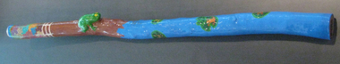
Artwork, other - Timber, acrylic paint, glass coat, beeswax, 'Frog Didgeridoo' by Peter Clarke, 2008
Peter CLARKE (1969- ) Gunditjamara (Lake Condah) Born Heywood, Victoria At two months old Peter Clarke was removed from his parents and placed in a Catholic boy's orphanage in Ballarat. The orphanage was closed and Peter was moved to a public orphanage where he discovered 'manners were not a necessity and you often had to take before you were ever given in this orphanage. ... This new orphanage was not a home for me but a prison of sadness and despair.' Disconnected from his country and lore Peter Clarke chose "my own path to land, county and water". Although his childhood memories are dark and bleak, he uses vibrant colours. This item is part of the Federation University Art Collection. The Art Collection features over 1000 works and was listed as a 'Ballarat Treasure' in 2007.Mallee Wood didgeridoo with vibrant colours. A natural wood imperfections have been used to emphasise what is recognisable as a frog. This work was purchased from the "My Art, My Life, My Colours' exhibition at the Federation University Post Office Gallery, May 2008.art, artwork, aboriginal, peter clarke, didgeridoo, stolen generation, st joseph's orphanage, sebastopol, my art, my life, my colours' exhibition, federation university post office gallery -
 Federation University Art Collection
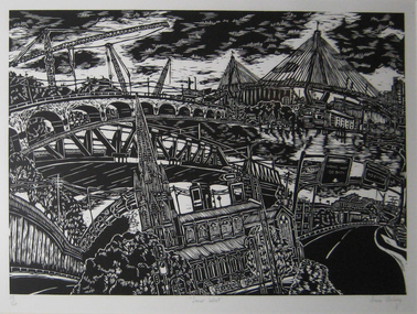
Work on paper - Printmaking - Relief Print, Starling, Anne, 'Innerwest' by Anne Starling, 2003
"In my woodblock print I have focused on the architectrure, streetscape and layout of the city. I am itrigued with teh organisation of cities and in teh creation of my own image. In this work I have almalgamated site drawings of buildings, streets and various structures to create a fish eye viewof the inner west of Sydney. By creating such a cityscape I form an historical document and record of the specific place."Anne STARLING (1967 - ) Born Sydney, New South Wales A graduate of the City Art Institute/UNSW College of Fine Arts, Anne Starling completed a Master of Art in 1994 and Master of Fine Arts by Research in 2012. Human interaction with the urban and industrial landscape is central to the work of Anne Starling. She focuses on the neglect that has occurred due to misuse and exploitation by industrial manufacturers, and the social and ecological structures of areas surrounding of Rhodes in Sydney, Fremantle in Western Australia and Port Kembla in New South Wales.Through relief and drypoint prints she examine changes that occur in this environment, presenting a commentary on the degradation and pollution of land by industry and the surrounding urban landscape. This item is part of the Federation University Art Collection. The Art Collection features over 2000 works and was listed as a 'Ballarat Treasure' in 2007.Framed black and white relief print (woodblock) representing a collage of various Sydney architecture. art, artwork, anne starling, printmaking, woodblock, print council of australia, sydney, architecture, bridge, cityscape -
 Falls Creek Historical Society
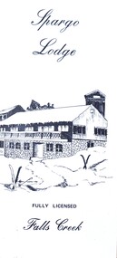
Flyer - Spargo Lodge
Ivan Spargo was a builder in Melbourne. In 1965 he and his wife Joy leased piece of land in Falls Creek and built Spargo Lodge. It was a dormitory style chalet designed to accommodate large groups and families. Their son, Rob and his wife Blanche purchased the site where the Falls Creek Hotel is today. In 1970 Rob’s sister Leonie and her husband Glenn joined the business, and they started operating in 1972. The family has been actively involved in the Falls Creek Community including the establishment of the Falls Creek Primary School and Falls Creek Search & Rescue. Rob also served as a member the Chamber and Resort Management Board. As the next generation stepped into the family business, Rob and Blanche retired to their home in Tawonga South in 2014 and Leonie and Glenn retired to Melbourne in 2017.This brochure is significant because it is linked to a prominent business and family in Falls Creek, Victoria. A small brochure publicising Spargo Lodge, Falls Creek. It is printed in brown text on buff coloured light card. When unfolded, one side shows a sketch of Spargo Lodge. The reverse side gives information about facilities and services, the tariff for regular and peak season, booking details and transport information.On front: Spargo Lodge FULLY LICENSED Falls Creekspargo lodge, falls creek accommodation, falls creek hotel -
 Wodonga & District Historical Society Inc
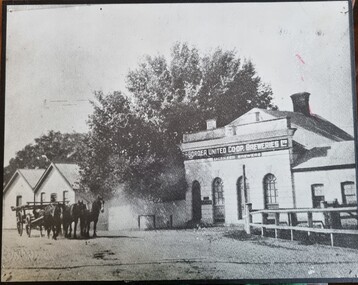
Photograph - Border United Co-op Breweries
The Border United Co-operative Breweries Limited was formed in 1911 by the amalgamation of The Albury Brewing and Malting Company Limited and The Anglo-Australian Brewery Company Proprietary Limited which operated breweries in Beechworth, Tallangatta and Yarrawonga. The Anglo-Australian Brewery was owned by the Billson family. By August the new plant was operating near the Union Bridge on the border of Victoria and NSW as shown in this photo. However the enterprise failed in August 1914 when not enough co-operative shares could be sold and also due to declining water quality. In December 1914 its spirit merchant’s license was transferred to the newly established Murray River Proprietary Company. In 1922, the brewery and 32 acres of land was sold to Mr E E Waite. Waite sold the buildings for removal.This image represents buildings related to early industries in the Albury-Wodonga region.Black and white image of brewery buildings. The image has been mounted on board.On building wall: "The BORDER INITED CO-OP BREWERIES LTD/LICENSED BREWERS"breweries northeast victoria, murray breweries, manufacturing history albury wodonga -
 Wodonga & District Historical Society Inc
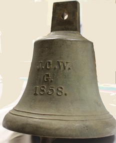
Functional object - Gordon Family Orchard Bell
The Gordons were architects and were associated with many buildings still standing in Albury and Wodonga, St Patrick's Church and the de Kerilleau Homestead among them. They established Vermont Orchard on 74 acres to the south of the Wodonga settlement. Here they grew fruit and nuts for the domestic and export market. The enterprising family also set about transforming some of the land by clearing it, creating streets and making general improvements. It was the biggest subdivision in Wodonga at the time. The 234 allotments in the Wodonga Estate were put up for sale by auction in May 1890. A total of 200 people were said to have attended. Gordon, William, Charles and Vermont streets in Wodonga are named after the family. This bell was used at the Vermont orchard to signal the beginning and end of the working day, as well as lunch breaks.The Gordon Family orchard bell is made of cast iron. It includes the inscription "J. C. W../G./1858." This is thought to represent the initials of John Gordon and sons Walter Joseph and Charles Goodwin Sylvester Gordon. There is some conjecture about this due to the date "1858". John was born in London, England in 1823 and died in 1880. Walter is generally accepted to have been born in 1857 and died 1903. In one family tree Charles is recorded as being born on 28 January 1858 but his birth was registered in 1860. The mystery of the date is therefore not fully resolved.On one side of the bell "J. C. W../G./1858."gordon family wodonga, gordon and gordon architects, vermont wodonga -
 Wodonga & District Historical Society Inc
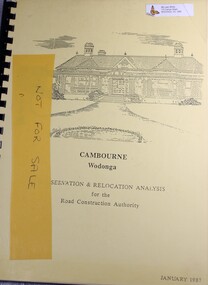
Booklet - Cambourne Wodonga : Conservation & Relocation Analysis for the Road Construction Authority, John & Thurley O'Conner, 1987
Research paper into the viability of relocating Cambourne Homestead in 2006 in order to make way for the widening and upgrade of the Hume Highway.non-fictionResearch paper into the viability of relocating Cambourne Homestead in 2006 in order to make way for the widening and upgrade of the Hume Highway. cambourne homestead wodonga, heritage building wodonga, carkeek family, potter family, building relocation -
 Victorian Farmers Federation
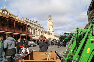
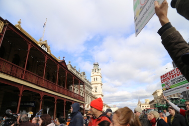
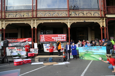
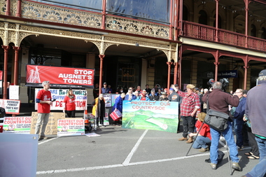
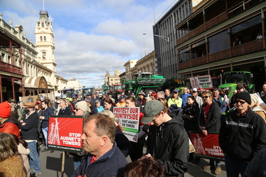
Photograph - Digital Photograph, Stop Ausnet Rally Ballarat - Katherine Myers, Scott Young, Charles Everist, 15 July 2022
VFF is seeking an appropriate framework to ensure farmers do not bear the cost of infrastructure on their farms. Overhead powerlines are proposed through the rich volcanic soils around Ballarat. This land supports 1200 jobs in processing in Ballarat. The towers would impact on the ability to irrigate crops, to use tractors around them, on biosecurity and on ability to use emergency equipment near them. VFF wants assurances that the managing entry to farm policy position will be adhered to and that a statewide strategic plan for renewable energy is prepared. https://www.vff.org.au/wp-content/uploads/2021/09/PS210901LG-Managing-Entry-to-Farms-adopted.pdf https://www.vff.org.au/wp-content/uploads/2021/09/VFF-Renewable-Energy-and-Energy-Efficiency-Policy-Statement-Meeting-172-June-2021.pdfadvocacy, renewable energy, farmers, protest, rally, managing entry to farm, victorian farmers federation, ballarat -
 Victorian Farmers Federation
Photograph - Digital Photograph, Stop Ausnet Rally Ballarat - post event scenes, 15 July 2022
VFF is seeking an appropriate framework to ensure farmers do not bear the cost of infrastructure on their farms. Overhead powerlines are proposed through the rich volcanic soils around Ballarat. This land supports 1200 jobs in processing in Ballarat. The towers would impact on the ability to irrigate crops, to use tractors around them, on biosecurity and on ability to use emergency equipment near them. VFF wants assurances that the managing entry to farm policy position will be adhered to and that a statewide strategic plan for renewable energy is prepared. https://www.vff.org.au/wp-content/uploads/2021/09/PS210901LG-Managing-Entry-to-Farms-adopted.pdf https://www.vff.org.au/wp-content/uploads/2021/09/VFF-Renewable-Energy-and-Energy-Efficiency-Policy-Statement-Meeting-172-June-2021.pdfadvocacy, renewable energy, farmers, protest, rally, managing entry to farm, victorian farmers federation, ballarat -
 Victorian Farmers Federation
Photograph - Digital Photograph, Stop Ausnet Rally Ballarat, 15 July 2022
VFF is seeking an appropriate framework to ensure farmers do not bear the cost of infrastructure on their farms. Overhead powerlines are proposed through the rich volcanic soils around Ballarat. This land supports 1200 jobs in processing in Ballarat. The towers would impact on the ability to irrigate crops, to use tractors around them, on biosecurity and on ability to use emergency equipment near them. VFF wants assurances that the managing entry to farm policy position will be adhered to and that a statewide strategic plan for renewable energy is prepared. https://www.vff.org.au/wp-content/uploads/2021/09/PS210901LG-Managing-Entry-to-Farms-adopted.pdf https://www.vff.org.au/wp-content/uploads/2021/09/VFF-Renewable-Energy-and-Energy-Efficiency-Policy-Statement-Meeting-172-June-2021.pdfadvocacy, renewable energy, farmers, protest, rally, managing entry to farm, victorian farmers federation, ballarat -
 Victorian Farmers Federation
Photograph - jpg image, Lisa Gervasoni, Stop Ausnet Rally Ballarat, 15 July 2022
VFF is seeking an appropriate framework to ensure farmers do not bear the cost of infrastructure on their farms. Overhead powerlines are proposed through the rich volcanic soils around Ballarat. This land supports 1200 jobs in processing in Ballarat. The towers would impact on the ability to irrigate crops, to use tractors around them, on biosecurity and on ability to use emergency equipment near them. VFF wants assurances that the managing entry to farm policy position will be adhered to and that a statewide strategic plan for renewable energy is prepared. https://www.vff.org.au/wp-content/uploads/2021/09/PS210901LG-Managing-Entry-to-Farms-adopted.pdf https://www.vff.org.au/wp-content/uploads/2021/09/VFF-Renewable-Energy-and-Energy-Efficiency-Policy-Statement-Meeting-172-June-2021.pdfphotos of Lydiard St Stop Ausnet Rallyadvocacy, renewable energy, farmers, protest, rally, managing entry to farm, victorian farmers federation, ballarat -
 Victorian Farmers Federation
Film - mp4 clip, Stop Ausnet Rally Ballarat Katherine Myers VFF speech
VFF is seeking an appropriate framework to ensure farmers do not bear the cost of infrastructure on their farms. Overhead powerlines are proposed through the rich volcanic soils around Ballarat. This land supports 1200 jobs in processing in Ballarat. The towers would impact on the ability to irrigate crops, to use tractors around them, on biosecurity and on ability to use emergency equipment near them. VFF wants assurances that the managing entry to farm policy position will be adhered to and that a statewide strategic plan for renewable energy is prepared. https://www.vff.org.au/wp-content/uploads/2021/09/PS210901LG-Managing-Entry-to-Farms-adopted.pdf https://www.vff.org.au/wp-content/uploads/2021/09/VFF-Renewable-Energy-and-Energy-Efficiency-Policy-Statement-Meeting-172-June-2021.pdfphotos of Lydiard St Stop Ausnet Rallyadvocacy, renewable energy, farmers, protest, rally, managing entry to farm, victorian farmers federation, ballarat -
 Melbourne Legacy
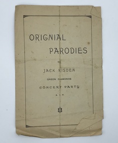
Booklet, Original Parodies by Jack Risden. Green Diamonds Concert Party A.I.F, c1918
A booklet by Jack Risden of song parodies. He has rewritten the songs; "They didn't believe me", "They call it Dixie Land" and "Samoa" for a concert during the first World War. Was with other World War 1 memorabilia that has come from Private John Basil McLean, 2nd Reinforcements, 37th Battalion, A.I.F. J.B. McLean (Service No. 13824) was from near Maffra, Victoria and enlisted on 22 January 1916. He embarked on 16 December 1916 for Europe. He spent time with the Australian Field Artillery (Pack Section). At the end of the war he worked for a year at the A.I.F. Headquarters in London before returning to Australia on the 'Ceramic', arriving in Portsea in 1920. His full war record is available from the National Archives of Australia (B2455, MCLEAN JBM).A record of publications made for the troops in World War 1 or made of material that came from soldiers.Booklet x 4 pages of songs for soldiers in World War 1.world war one, songs -
 Wyndham Art Gallery (Wyndham City Council)
Painting, Marlene Gilson, Waa Waa - Crow Feathers, 2021
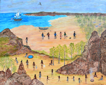
Waa Waa – Crow Feathers is a painting from Aunty Marlene Gilson’s 2022 exhibition ‘Bunjil Wour Kun Ya – Spirit of My Ancestors’. This work tells the story of Waa-Waa, the first Wadawurrung to see a white man, Matthew Flinders and his crew surveying the southern Australian coastline near the You Yangs on 1 May 1802. Speaking to Wyndham Art Gallery’s curatorial framework themes of Foregrounding, Habitat and Localism, the work portrays in Wadawurrung lore the first sighting of a European and acknowledges Australian First Nations peoples original and ongoing connections with land, history, politics and knowledges of place. The scene is overlooking the You Yangs which is deeply connected with the local place and habitat of the Werribee Plain. Aunty Marlene Gilson is a Wathaurung (Wadawarrung) Elder living on country in Gordon, near Ballarat. Marlene Gilson’s multi-figure paintings work to overturn the colonial grasp on the past by reclaiming and re-contextualising the representation of historical events. Learning her Wathaurung history from her grandmother, Gilson began painting while recovering from an illness. The artist’s meticulously rendered works display a narrative richness and theatrical quality akin to the traditional genre of history painting. Gilson, however, privileges those stories relating to her ancestral land, which covers Ballarat, Werribee, Geelong, Skipton and the Otway Ranges in Victoria. Often including her two totems, Bunjil the Eagle and Waa the Crow, Gilson’s paintings not only reconfigure historical narratives, but display her spiritual connection to Country. australian first nations art, cultural story, australian painting, wathaurung, female artist -
 Warrnambool and District Historical Society Inc.
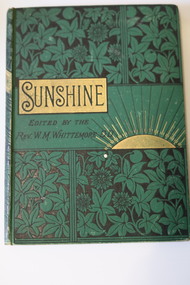
Book - Children's Magazine, Rev. W. Meynell Whittemore, Sunshine for 1886, 1886
A Children's Annual formed by re-publishing one year's issues of a monthly magazineThis is a book of 190 pages. It has a green cover with embossed floral patterns and a rising sun sketch outlined in gold. The black printing on the cover and spine has a gold patterned background. The pages contain advertisements, printed material and black and white sketches. fictionA Children's Annual formed by re-publishing one year's issues of a monthly magazine matilda logan, st. john's presbyterian church warrnambool, logan's beach -
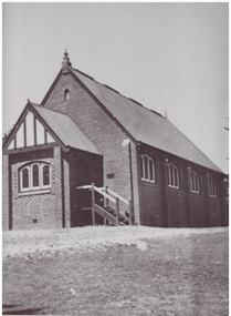 Linton and District Historical Society Inc
Photograph, Methodist Church, Grantley Street, Linton
Methodist Church meetings and services are known to have been held in tents on the Lintons diggings from the late 1850s. A small wooden church was built in in 1858-59 in Sussex Street, Linton (near where Shepherd's store was located). Sunday School meetings began there in November 1859. By 1860 the church building was considered too small. The land was sold to Mr. Brewer, and the building was removed to a site in Grantley Street and enlarged. Shortly after this, it was decided to build a new church, a wooden structure which was opened in 1861. This building was still in use at the time of the Methodist Church Jubilee in 1910, however around 1905 a fund was established to build a new brick church (pictured), which was opened in 1913. This building was sold and became a private residence about 1979.Black and white photograph of brick church building, leadlight windows in three sections at front and alongside. Sets of steps leading to doors on both sides of church front entrance porch.methodist church linton -
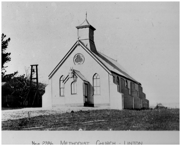 Linton and District Historical Society Inc
Photograph, Methodist Church, Linton, Timber Construction, Opened 1861
Methodist Church meetings and services are known to have been held in tents on the Lintons diggings from the late 1850s. A small wooden church was built in in 1858-59 in Sussex Street, Linton (near where Shepherd's store was located). Sunday School meetings began there in November 1859. By 1860 the church building was considered too small. The land was sold to Mr. Brewer, and the building was removed to a site in Grantley Street and enlarged. Shortly after this, it was decided to build a new church, also of timber construction, which was opened in 1861. This building (pictured) was still in use at the time of the Methodist Church Jubilee in 1910, however around 1905 a fund was established to build a new brick church which was opened in 1913. This brick building was sold and became a private residence about 1979.Black and white photograph which has been printed as a post card. The photograph shows a timber church which has a kind of turret, and side buttresses. Bell tower on left of picture. Large lamp hanging from entrance porch.methodist church linton, postcards -
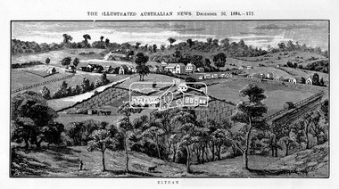 Eltham District Historical Society Inc
Photograph, Samuel Calvert, Eltham, The Illustrated Australian News, December 26, 1884, p212, 1884
A description in the newspaper near the illustration (page 210) reads as follows: "Eltham is a pretty little township on the Yarra Flats road, about 14 miles east north east of Melbourne, from which place there is communication by way of Heidelberg. It has a population of nearly 400 inhabitants, but in addition it is the centre of a large district extending over about 203 square miles, having a population of 2344. The land in the district is mostly used for grazing purposes, although as a rule the small farms grow a good deal of wheat, oats and other agricultural produce. A large quantity of fruit, especially raspberries and strawberries, is also produced, the rich alluvial flats along the creek upon which the township is situated being very well adapted for that purpose. Gold has also been found in the vicinity of the township, but not in remunerative quantities". This photo forms part of a collection of photographs gathered by the Shire of Eltham for their centenary project book,"Pioneers and Painters: 100 years of the Shire of Eltham" by Alan Marshall (1971). The collection of over 500 images is held in partnership between Eltham District Historical Society and Yarra Plenty Regional Library (Eltham Library) and is now formally known as 'The Shire of Eltham Pioneers Photograph Collection.' It is significant in being the first community sourced collection representing the places and people of the Shire's first one hundred years.Digital imageshire of eltham pioneers photograph collection, eltham, illustrated australian news -
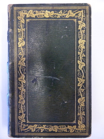 Warrnambool and District Historical Society Inc.
Book, Thalaba the destroyer Vol 1, 1821
This book was written in 1801 in an epic poem form. It is unrhymed. It falls into the category of fantasy. The original owner of this book seems to have been John Bland. He is most important in the early history of Port Fairy and had a business in Port Fairy with John Cowtan (corn millers and general merchants). The Cowtans originally had land in the vicinity of the Cassady property of Boughton, Merri River (in Caramut Road near Cassady’s Bridge today) and were related by marriage to the Cassadys. A later owner of the book was William Anderson whose father came to the Yangery district in 1854 and established the property of Rosemount and William remained in this area until his death in 1909. The Andersons were related by marriage to the Cassadys and this book came to us following a clearance sale at the Cassady property, Boughton. This book is of great interest less for its literary content than for its ownership which probably dates back to the 1840s. It is associated with the families of Bland, Cowtan, Cassady and Anderson, all early settlers in Warrnambool and district.This is a brown leather-covered book of 271 pages. The cover has gold decorative borders and patterns and gold lettering. The pages are gilt-edged. The book is the fourth edition of volume one of a Robert Southey poem and has a Preface and Books 1 to 5 with Notes. The inscriptions are handwritten in black ink. One signature has not been deciphered. ‘Wm. Anderson’ ‘John Bland’ william anderson,, rosemount, william cassady, john bland, john cowtan, thalaba the destroyer, warrnambool, poem thalaba the destroyer, 19th century poems, robert southey books