Showing 10891 items
matching land
-
 City of Moorabbin Historical Society (Operating the Box Cottage Museum)
Newsletter, City of Moorabbin Historical Society Feb 2009, February 2009
The City of Moorabbin Historical Society was formed c 1960 by a group of Moorabbin residents who were concerned that the history of the area should be preserved. A good response to a call for items related to the historical area of Moorabbin Shire brought donations of a wide variety of artefacts which are now preserved by the current members of CMHS at Box Cottage Museum . Helen Stanley, Secretary of CMHS, began producing a Newsletter for members in April 2007 to provide current information and well researched items of historical interest.Helen Stanley has produced a bi-monthly Newsletter, 2007 - 2013, for the members of the City of Moorabbin Historical Society that contains well researched interesting historical items, notification of upcoming events, current advice from Royal Australian Historical Society , Museums Australia Victoria and activities of Local Historical Societies. The Newsletter is an important record of the activities of the CMHS. Tom Sheehy, past President of CMHS, was an Historian and Author of ‘Battlers Tamed the Sandbelt’. 2 x A4 paper printed on 3 sides Issue 10 of the bi-monthly, City of Moorabbin Historical Society Newsletter produced by Society member and Secretary, Mrs Helen Stanley in February 2009. The Victorian Bushfire tragedy around Marysville is still unfolding as this Newsletter is written. The first meeting for the year is February 22nd and subscriptions are due. An excerpt is transcribed from the City of Moorabbin Historical Society Newsletter October 1962, “A Piece of History in Ormond” by an unknown eyewitness author, describing the original “Box Cottage” situated in Mr J. Reitman’s cement products factory at 306 Jasper Road, Ormond prior to demolition. The current Editor gives information obtained from further recent research . An Article by Tom Sheehy, past President and Historian, February 1979 “The Vineyards of Moorabbin”. The ‘Brighton Estate” began when Henry Moor brought Vine cuttings from Camden NSW 1848 and they were productive after 3 years. Many Vineyards then appeared from Port Phillip Bay to East Boundary Road and produced 2/3 of the annual Victorian grape crop. Disease or insect caused failure in1858 and the land reverted to market gardens. A coloured photocopied photo of Box Cottage 2005. CITY of MOORABBIN HISTORICAL SOCIETY / FEBRUARY 2009 NEWSLETTERcity of moorabbin historical society, stanley helen, sheehy tom, melbourne, moorabbin, brighton, cheltenham, ormond, bentleigh, vineyards, fruit growing, vine diseases, winemaking, grapes, market gardeners, pioneers, early settlers, moorabbin shire, box cottage museum, dairy, port phillip bay, brighton estate, moor henry, cambden estate, reitman j., reitman w., cement, pottery, jasper road ormond, east boundary road brighton, dendy’s special survey 1851, point nepean road, south road brighton, thomas street brighton, north road brighton, county of bourke, box h., box william, bruton william, brighton brewery, parish of moorabbin, parish of prahran, markets, shingle roof, weather-board, downward mr., mckinnon -
 Bendigo Historical Society Inc.
Document - INDEXES
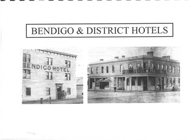
Indexes Includes Names from the 1856 Petition Bendigo and District Hotels Final Marunari List Terry Davidson 1871 - 2018 Index to RHSV Bendigo Branch Newsletters Nov. 1971 - July 2002 Helen Mainka 1954 Bendigo Business District Directory McConnell’s Street and general Directory Date unknown Victorian Directory 1904 Bendigo and District Directory 1904 – 1905 Bendigo district general Directory 1859 City of Bendigo Historical Information Bendigo Hotels compiled by Len Bennetts Hotels of Bendigo and District Compiled by Len Bennetts Sandhurst Land Sales 1854 – 1856 Ralph Birrell Chronicles of Bendigo from the Bendigo Advertiser Christmas Supplement December 22 1904 Some Photographers 1850 – 1900. Including some Bendigo Photographers 1854 – 1958 St. Patrick’s Annual Sports advertisers. Date Unknown Fatalities listed in bendigo Advertiser 1888-1935. Two copies One by year. One alphabetical. District statistics - Mayors and Shire Presidents, Bendigo Football League Premiers 1880- 1987, Sportstar of the year 1965-1987 Plans of townships and Parishes held at Ducley House. From the Bendigo Lands Office 1976. -
 Bendigo Historical Society Inc.
Document - CONNELLY, TATCHELL, DUNLOP COLLECTION: LEGAL PAPERS, 1886
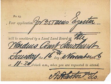
Documents. Connelly, Tatchell & Dunlop - Legal Papers. 1 - 1886 - Letter from Meudell George D re Holloway. Letterhead - Horrell & Meudell (R F Horrell & G D Meudell), Auditors, Secretaries and Accountants, 10 Market Buildings, William Street, Melbourne. 2 - 1886 - Post Office Telegraph 4 Nov 1886 for Merrifield S from Bruce T?, St Kilda asking, 'Where is Penders blackboy Pompey'. Reply from Merrifield mentions 'Pompey was remanded Melbourne on Friday last. Enquire at watch tower there.' Also mentions 'I don't know whether Mr Bruce is Pompey's friend or Caesars (Mr Penders)' on Attached handwritten note dated 4 Nov 1886. 3 - 1886 - Letter from Williams A M, Solicitor, 28 Queen Street, Melbourne re Bagot? V Budden 4 - 1886 - Post card to Suffern? Mr William James, Elmore from Lester A,A. Land Officer, re 255 acres, Egerton. Mentions Wardens Court, Sandhurst. 5 - 1886 - Letter from Drues W T, 19 Temple Court re A'Becketts fees. 6 - 1886 - Letter from Barrett Henry, Runnymede East.cottage, miners, connelly, tatchell & dunlop, meudell george d, holloway, horrell & meudell, merrifield s, bruce t?, penders, pompey, caesars, williams a m, bagot, budden, suffern mr william james, lester a a, drues w t, a'becketts, barrett henry -
 Bendigo Historical Society Inc.
Document - MCCOLL, RANKIN AND STANISTREET COLLECTION: NEW STAR GOLD MINE HARRIETVILLE NL, c1934
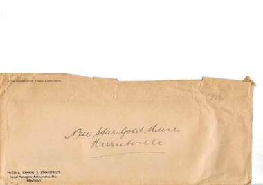
McColl Rankin & Stanistreet, New Star Gold Mine Harrietville NL. a/ Department of Mines 20.2.1934 laboratory reports results, 3 receipts attached, list of general expenses, quarter ended 30.4.1934, heading Dargo ''Gold Butterfly'' Gold Butterfly crossed out hand inscription Gold Reefs Syndicate, Wanangatta, Dargo. b/ copy of Purchase agreement of leasehold land for the purpose of mining. Dated 28.6.1934. c/ Payments by R.A. Rankin - Office Account A/C Leases No's. 5187 and 5195 Dargo, Gippsland, prior to exercise of option. Inscription: Paid by New Star Company ?? On ?? 1934 ?? ?? ??. d/ Letter: purchase of Leases No's 5187 & 5195 Black Snake Black Snake Creek, Dargo. Dated: 22.8.1934. e/ letter acknowledging receipt of payment for application of Lease No. 5187, lease will be delayed until precise area is determined. Signed: ?? Rankin. 3 pence stamp for stamp duty attached. Dated: 23.8.1934. f/ Memo, Mr Grelis. Re Leases No's 5187 & 5195 Dated: 4.9.1935. Signed: ?? g/ McColl Rankin & Stanistreet business envelope. Envelope labelled New Star Gold Mine Harrietville. 46.organization, business, gold mine, mccoll rankin & stanistreet, new star gold mine harrietville nl. dargo ''gold butterfly'' gold reefs syndicate, wanangatta, dargo black snake black snake creek 1934 1935 -
 Southern Sherbrooke Historical Society Inc.
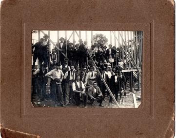
Photograph, Watson's Photos, Belgrave, Building Austral Hall, Belgrave, 1920
Black and White photo on a brown cardboard mount, showing a large group of men (about 30) and children (about 6) in front of and on the wooden frame of the partially constructed Belgrave Catholic Church Hall, Austral Hall, corner of (now) Reynolds Lane & Burwood Highway. The men are dressed in various combinations of hats, ties, shirts, jackets, trousers and work aprons. Some have tool belts or are holding hammers and other tools. Two small girls are seated on their fathers' laps. A man is sitting on his haunches at the front. He is wearing a suit and loose bow tie and holding a hat. He appears to be an official. Another man is patting or holding a dog. The building seems to have two walls partially constructed. There are trees visible in the background which are on the high side of the main road of Belgrave. A moulded brown cardboard mount measures 24.7 X 20.00. On the reverse side is written in pencil, 'Building Church hall/ at/ Belgrave/ Saturday 11th Dec 1920.' There is a stamped business name which reads 'Watson's/ photos/ Belgrave.' The Hall was built by largely volunteer labour as the Austral Hall, financed largely by Harry Luscombe's dances and functions. The land was donated by the Buckley Family. On the reverse side is written in pencil, 'Building Church hall/ at/ Belgrave/ Saturday 11th Dec 1920.' There is a stamped business name which reads 'Watson's/ photos/ Belgrave.' -
 Heidelberg Theatre Company Inc..
Program Photos ReviewSet Design, Liliom by Ferenec Molnar directed by Joy Youlden
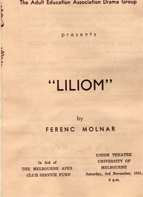
The Adult Education Association Drama Group originally staged Liliom at the Union Theatre, University of Melbourne on Saturday, 3rd November, 1951, at 8pm and on the 8th November it was re-staged by them as the opening production of the The City of Heidelberg Repertory Company, now known as the Heidelberg Theatre Company Inc. in the Eistedford Hall, Ivanhoe. Sketch for Prologue, Fair Ground Scene, and Sketch for Scenes 2 and 3, The Tin Type Shop, for Adult Education Association Drama Group production at the Union Theatre from 1st – 3rd November, 1951. Resulting sets were transported to the Eisteddfod Hall, Ivanhoe and used in the opening production in January, 1952 for the newly formed City of Heidelberg Theatre.Sketch for Prologue, Fair Ground Scene, and Sketch for Scenes 2 and 3, The Tin Type Shop, for Adult Education Association Drama Group production at the Union Theatre from 1st – 3rd November, 1951. Resulting sets were transported to the Eisteddfod Hall, Ivanhoe and used in the opening production in January, 1952 for the newly formed City of Heidelberg Theatre. Sketch for Prologue, Fair Ground Scene, and Sketch for Scenes 2 and 3, The Tin Type Shop, for Adult Education Association Drama Group production at the Union Theatre from 1st – 3rd November, 1951. Resulting sets were transported to the Eisteddfod Hall, Ivanhoe and used in the opening production in January, 1952 for the newly formed City of Heidelberg Theatre Company. Photo from unidentified newspaper of the director of Liliom by Ferenc Molnar, Joy Youlden.an Adult Education Association Drama Group production at the Union Theatre from 1st – 3rd November, 1951 and restaged at the Eisteddfod Hall, Ivanhoe as the opening production in January, 1952 for the newly formed City of Heidelberg Repertory Group. The Adult Education Association Drama Group performers, backstage workers and technicians staged the play at the Eisteddfod Hall in Ivanhoe. Local Councillor E.A. Carlyle attended and addressed the audience. Reg Rudd is described as director-producer. He announced another Repertory evening in February. Inagural production under the name of The City of Heidelberg Repertory Company, now known as the Heidelberg Theatre Company Inc., staged in the Eisteddfod Hall, 14 Ivanhoe Parade, Ivanhoe, Victoria, Australia on the 8th November, 1952.All items in good condition. Original and one colour photocopy of hand drawn sketches for the Prologue and Scenes 2 and 3 settings in blue biro with watercolour washes on ecru paper. On the back side of paper with scene sketch of Act 1. Photo – Joy Youlden - Small black and white cutting from unidentified newspaper on newsprint which has yellowed, Cutting has been glued onto ecru A4 paper sheet. Sketch for Scene 6, The Land Beyond, and Sketch for Scene 7, Julies House 16 Years later, an Adult Education Association Drama Group production at the Union Theatre from 1st – 3rd November, 1951. Resulting sets were transported to the Eisteddfod Hall, Ivanhoe and used in the opening production in January, 1952 for the newly formed City of Heidelberg Repertory Group. Sketches for Scene 4, The Railway Embankment, and Sketch for Scene 5, Behind The Shop, an Adult Education Association Drama Group production at the Union Theatre from 1st – 3rd November, 1951. Resulting sets were transported to the Eisteddfod Hall, Ivanhoe and used in the opening production in January, 1952 for the newly formed City of Heidelberg Repertory Group. Handwritten detail of scene numbers and names, name of producer, theatre company AEA (Adult Education Association) Drama Group Show and place, Union Theatre.eistdford hall, fern matthews, city of heidelberg repertory group, adult education association drama group, liliom, liliom by ferenec molnar directed by joy youlden, 1952, 1 -
 University of Melbourne, Burnley Campus Archives
Album - Digitised, Sandra Pullman, Sandi Pullman Album, 1998-2000
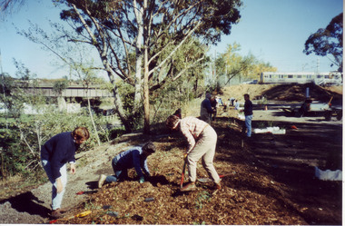
93 photographs from Sandi Pullman's album. Scanned March 2013. Some have descriptions on reverse. Originals remain with Sandi Pullman (Student, FOBG). (13-19) John Delpratt's Grassland Project FOBG 30.05.98. (20-30) FOBG Working Bee 10.10.98 Ground Cover Trial Plots. (1-12) First Friends of Burnley Gardens Working Bee, "Planting the Back Car Park along the trainline 2nd May, 1998. (First Stage of the car park sited on Richmond City Council land at the rear of the College completed 1980.) (31-45) Back Car Park 11.09.99. (46-51) Native Garden 27.11.99. (52-53,72-75) 150th Celebration of What? Oct 2000, Ellis Stones Rockery Oct 2000. (54-58, 71, 76, 84, 86, 88-91, 93) Harvesting Grasses. (59-62) Nicki Rose from the Australian Plant Society presenting Dr Greg Moore with $1,500 cheque at an afternoon tea on the Citriodora Lawn 31.03.2000. (63-70) Melbourne International Flower & Garden Show (M.I.F.G.S.) 2000. (77-83) First Pruning Day 1999.sandi pullman, sandra pullman, fobg, john delpratt's grassland, working bee, native garden, ellis stones rockery, harvesting grasses, nicki rose, australian plant society, dr greg moore, melbourne international flower & garden show, m.i.f.g.s., back car park, wrong 150th celebrations, ground cover trials -
 Ringwood and District Historical Society
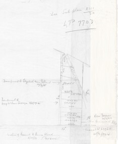
Document - Handwritten extract, Certificate of Title - LP7703 Mary Ann Williams, Bedford Road Ringwood, County of Mornington dated 18/4/1912
Two pages of notes and subdivision sketches on tracing paper.Mary Ann Williams of Bedford Road Ringwood in the County of Mornington, wife of John Williams of the same place, Gardener, is now the proprietor of and estate in fee simple subject to the encumbrances notified herunder in all that piece of land deliniated and coloured red on the map in the margin, containing 72 acres 3 roods and 30 perches of thereabouts being parts of Crown Portion 16, Parish of Ringwood, County of Mornington, together with a right of carriage way over the road coloured brown on the said map. 18/4/1912. Encumbrances - special railway conditions contained in Crown Grant to Nelson Polak. Transfer to Elizabeth Anne Yelland 10/9/1918 Transfer to Mary M Savage 16/5/1912 (?) Easement - Emma Blood 8/10/1919 (?) Turner - 12/3/1924 18 Greenwood Avenue 3/7/1915 Caveat no.63960 25/8/1924 -
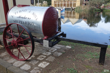 Flagstaff Hill Maritime Museum and Village
Vehicle - Furphy Water Cart, J. Furphy & Sons, c. 1942
This horse-drawn, two-wheeled cart with a tank, is known as a Furphy Farm Water Cart that was made in Shepparton, northern Victoria, c. 1942. John Furphy (1842-1920) was born in Moonee Ponds, in 1842 to Irish immigrant parents and subsequently raised in the Yarra Valley before the family moved to Kyneton in central Victoria, where he completed an apprenticeship with the firm Hutcheson and Walker. Murphy began operations of his own at a site on Piper Street in Kyneton in 1864. He relocated for a business opportunity and founded the first blacksmiths and wheelwrights shop in the newly surveyed town of Shepparton in 1873. Furphy invented many farming tools and machines including a patented grain-stripper, and won awards at the 1888-89 Melbourne International Exhibition. His most famous invention is the Furphy Farm Water Cart, designed in the 1880s, at a time when water for most households and farms was carted on wagons in wooden barrels. The Furphy’s water cart is a single item that combines a water metal tank and a cart. The design of the cart was simple yet effective, and became popular very quickly and established itself as a vital piece of farming equipment. The water cart has had a number of words cast into its ends over many years. References to the foundry’s location in Shepparton, as well as advertising of other products also manufactured by J. Furphy & Sons were present on the ends. However, the most significant set of words to feature on the tank, was a poem encouraging continual improvement: ‘Good Better Best, Never Let it Rest, Until your Good is Better, And your Better Best’. During The Great War (1914-1918), the water cart was used by the Australian militarily at a large AIF (Australian Imperial Force) camp in Broadmeadows (Melbourne) where thousands of men were camped for months, before being transported aboard. Furphy Water Carts provided water to the troops, and were usually placed near the camp latrines, which was one of the few places the troops could share gossip and tall tales away from the prying eyes and ears of their officers. The water cart drivers were also notorious sources of information, despite most of their news being hearsay, or totally unreliable. By the time the men of the AIF were in engaged in combat on the Gallipoli Peninsula and the Western Front, the carts used for water supply had no markings and became simply referred to as Furphys. This owed as much to the coining of the term ‘Furphy’, Australian slang for suspect information or rumour. After a number of decades as principally a soldier’s word, 'Furphy' entered the broader Australian vernacular and was used mainly by the political class until recently when the term was taken up by a Australian brewer as a beer brand. This Furphy Water Cart was purchased by Friends of Flagstaff Hill in 2014. The support of local individuals, organisations and businesses enabled its restoration and later its installation alongside the existing late-19th century water pipe stand and 1940s hand pump The Furphy Farm Water Cart is of historical significance as it represents a famous Australian time-saving and energy-saving invention of the 1880s, replacing the labour intensive activity of collecting and dispensing water from barrels and casks on the back of carts. The water cart’s connection with manufacturing companies J. Furphy & Sons and Furphy Foundry are significant for being early Australian businesses that are still in operation today. Furphy carts are of military significance for the role they played during The Great War (1914-1918) in Australian army camps, and theatres of war in Europe and the Middle East, to supply the AIF troops with fresh water. A wooden framed, two-wheeled, horse-drawn cart, fitted with a horizontally mounted, cylindrical metal tank. The tank is made of rolled, sheet steel with a riveted seam, and cast iron ends with cast iron ends. The spoked metal wheels have fitted flat iron tyres and metal hubs. A metal pipe is joined to the outlet. The tank is silver coloured, the ends, wheels and trims are crimson, and the script lettering on tank sides is black. There are inscriptions on the tank, ends, and hubs. The water tank was made in 1942 in Shepparton, Australia, by J. Furphy & Sons and has a capacity of 180 gallons (848 litres). Hub perimeter, embossed “J. FURPHY & SONS” “KEEP THE / BOLTS TIGHT” Hub centre embossed [indecipherable] Tank, each side, painted “J. FURPHY & SONS / Makers / SHEPPARTON” Tank ends, embossed – “FURPHY’S FARM WATER CART” “BORN ABOUT 1880 – STILL ‘GOING STRONG’ 1942” “j. FURPHY & SONS / MAKERS / SHEPPARTON - VIC “ “S - - - - - L MANUFACTURERS” [SPECIAL] “SPIKE ROLLERS” “SINGLE TREES” “PLOUGH WHEELS” “IRON CASTINGS” “LAND GRADERS” “STEEL DELVERS” “CAST IRON PIG” “CHAIN YOKES” “GOOD – BETTER – BEST / NEVER LET IT REST / TILL YOUR GOOD IS BETTER / AND YOUR BETTER – BEST” Image [Stork carrying a baby] above shorthand, transcribed "Produce and populate or perish" Image [Furphy Pig Feeder] beside ‘Cast Iron Pig’ Shorthand, transcribed “"Water is the gift of God but beer and whiskey are concoctions of the Devil, come and have a drink of water"warrnambool, flagstaff hill maritime museum, water cart, furphy cart, furphy tank, furphy farm water cart, furphy, john furphy, john furphy & sons, furphy foundry, kyneton, shepparton, mobile water tank, jinker, hutchinson & walker, blacksmith, farm equipment, implement maker, tool maker, horse drawn, stork and baby, good, better, best, barrel, tank, first world war, wwi, eastern front, gallipoli, j furphy & sons -
 Ringwood and District Historical Society
Document - Folder, Proposed Auction - Wellwood Cottage, Glenvale Road, Ringwood - 1955
Folder containing auction advertisements and incomplete copies of Certificate of Sale from an abortive November 1955 auction of "Wellwood Cottage" Elizabethan style residence under instructions from Keith Wellwood Storey. Newspaper auction clippings from Melbourne Age and Argus issues during November 1955 attached to folder. Packet of family photographs circa 1950s featuring exterior and interior views of the residence and grounds including 2 with captions - "... Rosemary putting food out for birds ..." and "Wellwood Cottage taken in snow in July '51 from Glenvale Road". Property description: "Elizabethan type residence in brick and timber of 2 storeys and attic, containing lounge, dining room, kitchen, living room, study, 3 bedrooms, 2 attic rooms, garage, large workshops. Childrens' 2 storey play house, tennis court, barbecues, etc. Elec. H.W.S., septic sewerage. This desirable and unique property is situated in 5 acres of land, including garden of ornamental shrubs and pine plantation. High position approximately 1-1/2 miles from Ringwood Station. Vacant Possession. Terms 10% deposit, balance 60 days. Inspection 2-4p.m. Saturdays, or by appointment with the Auctioneer, C.E. Carter & Son, 126 Whitehorse Road, Ringwood, WU6024." Accompanying handwritten sales notes researched in 2024 by Richard Carter - Carter Real Estate - "Property did not sell then, but was later sold to Bethunes. House demolished circa 2020". -
 Glen Eira Historical Society
Album - Album page, Booran Road, 30, Circa 1972
This photograph is part of the Caulfield Historical Album 1972. This album was created in approximately 1972 as part of a project by the Caulfield Historical Society to assist in identifying buildings worthy of preservation. The album is related to a Survey the Caulfield Historical Society developed in collaboration with the National Trust of Australia (Victoria) and Caulfield City Council to identify historic buildings within the City of Caulfield that warranted the protection of a National Trust Classification. Principal photographer thought to be Trevor Hart, member of Caulfield Historical Society. Most photographs were taken between 1966-1972 with a small number of photographs being older and from unknown sources. All photographs are black and white except where stated, with 386 photographs over 198 pages. From Glen Eira Heritage Management Plan 1996 by Andrew Ward: In 1888, John Leek, a trainer, owned Lot 15, measuring one and three quarter acres, in Booran Road, north side between Glen Eira and Neerim Roads. The land backed onto the Caulfield Racecourse Reserve. NAV was £45. In 1890 Leek built for his residence, a ten roomed brick house on the site. NAV was £200. Leek was the owner/trainer of "Ingliston" who won the Caulfield Cup in 1900. Upon the horse's death in 1901, Leek is understood to have defied tradition by spending £20 on boots for the "ragged urchins in Bourke Street" instead of "shouting" at the bar. By 1899, the property was owned and occupied by Alfred Merrill, a dentist and was known as "Andover". NA V had decreased to £ll0. By 1910, Leslie Macdonald, a gentleman had purchased the property and renamed it "Moidart". In 1910-11 Macdonald sold it to John Robertson. The property had extensive wood stables on its north-east boundary and several other outbuildings. The house continued to be described as "Brick, ten rooms" as it was in 1926 when it was owned and occupied by John Arthur, a managing director. The land measured la.2r.31p. and had a NAV of £235. Nine people lived there. In 1926, Arthur also owned the adjoining Lot 16. Other racehorses of note, known to have been stabled here include Sobar, Havelock, Proud, Future and Lord.Victorian Heritage Register https://vhd.heritagecouncil.vic.gov.au/places/13532 What is significant? Lord Lodge is a thoroughbred racehorse training complex adjacent to Caulfield Racecourse, established in 1890. The area immediately around the racecourse has been associated with horse racing activities and businesses servicing the industry since the development of the racecourse in late the 19th century. Lord Lodge was named by the present occupants after the champion racehorse Lord who was stabled there in the 1950s. In the early 20th century the property was known as 'Andover' and subsequently 'Moidart'. The site consists of a single storey brick Italianate villa, jockeys' quarters, stables and open day yards with direct access to Caulfield racecourse from the rear of the property. The villa of 10 rooms on bluestone foundations was constructed in 1890 by John Leek, a horse trainer who purchased the newly subdivided land in 1888. The house has many Victorian Italianate or Boom Style features although it is more modest than many villas of its style. It has an asymmetrical facade with a faceted bay window and a prominent central tower with low pitch pyramidal roof that provides a clear view of the racecourse. Other characteristic features include stilted segmented arches, bracketed eaves, stucco wall finish and cast cement ornamentation. A room has been added on the north-facing verandah in sympathetic style and finish. Internally the rooms are substantially intact with original marble fireplaces and intricate ceiling roses and cornices. An entrance toward the rear of the southern side of the house is said to be where the stable hands, jockeys and other staff lined up for their meals. In the southeast corner of the property, backing directly on to Caulfield racecourse, is a substantial late Victorian timber stable, probably constructed in the 1890s but first appearing on the property title in 1910. The stable has 12 stalls, a loft and brick pavement and jerkin head roof form with varnished pine-lined ceiling carried on a chamfered timber frame. It has an original roof lantern. The doors of the stalls are not the original sliding doors but swing doors obtained from a barn at Epsom Racecourse in Mordialloc prior to demolition. Outside the gambrel roof has fretted barges but the building is otherwise utilitarian. Timber throughout the stalls has been worn by chewing and rubbing of horses over the century of its use. In the southern half of the property are open day yards where the racehorses are kept during the day. The red brick, single storey jockeys' quarters to the rear of the villa were probably built around 1950. A small brick, possibly late Victorian structure on the eastern boundary thought to have originally been a gardening shed, has been converted to a stable of two stalls. Modern concrete brick stables fill the northeast portion of the property. At the front of the property two Moreton Bay Figs (Ficus macrophylla), probably planted in the late 19th century, provide shade for horses in the day yards. In the 1890s John Leek sold the property, relocating his training facility to one of the newly established racecourses at Mentone or Mordialloc (Epsom). By 1899, the property was owned and occupied by Alfred Merrill, a dentist, who named the property 'Andover'. In 1910 it was purchased by Leslie McDonald, a gentleman, and renamed 'Moidart'; sold in 1910-1911 to John Robertson; and again in 1926 to John Arthur, a racehorse owner. The Victorian Amateur Turf Club purchased the property in the late 1930s and since this time has been leased to racehorse trainers. It is unclear whether the property operated as a training facility between 1899 - 1926. Several notable trainers and jockeys are associated with Lord Lodge. The best known is Arthur 'Scobie' Breasley, Australia's most successful jockey who was apprenticed to trainer Pat Quinlan at Lord Lodge (then 'Moidart') from 1928 - 1935. Breasley rode winners of the Caulfield Cup in four successive years 1942-45 and again in 1952. John Leek, the original owner of Lord Lodge trained Ingliston, the 1900 Caulfield Cup winner. Along with 'Lord' a number of well known racehorses including Sobar, Havelock, Proud and Future were trained at Lord Lodge .....Page 40 of Photograph Album with three landscape photographs of the exterior of this house.Handwritten: 30 Booran Road [top right hand corner] / 40 [bottom right]trevor hart, jenny o'donnell, booran road, mansion, caulfield east, ingliston, sobar, havelock, proud, future, lord, andover, moidart, lord lodge, grace darling, caulfield racecourse reserve, victorian amateur turf club, historic buildings register, national estate register, caulfield cup, horses, stables, horse racing, racehorses, outbuildings, racehorse trainers, depression, 1890s, brick houses, mansions, towers, verandahs, stained glass, italianate style, victorian style, architectural features, architectural styles, john leek, leslie macdonald, john arthur, john robertson, alfred merrill, jenny odonnell -
 Flagstaff Hill Maritime Museum and Village
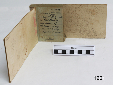
Financial record - Receipt Book, Department of Works and Mines Victoria, July 1936 (first record)
Establishment and Functions Prior to 1860, the Chief Secretary's Department had been responsible for the administration of the gold fields and associated mining activities. In November 1860 a Commissioner of Mines was appointed and a Department was established under his administration. For the period November 1861 to June 1863, the Postmaster General was responsible for the Mining Department. A Minister of Mines was again appointed in 1863. Responsibilities of the Department of Mines were: 1. Regulation of mining and related public works activities through the issue of miners rights, business and residence licences, mining leases, mineral and other prospecting licences 2. Superintendence of the activities of mining surveyors, registrars, wardens and Mining Boards. 3. Investigation of the state's geological structure, mineral wealth and underground water resources 4. Development of the mining industry 5. Supervision of the safe working of mines, machinery and quarries including checking the credential of mine managers, inspectors and operators 6. Regulation of the disposal of sludge and other waste products 7. Administration of the Victorian Mining Accident Relief Fund. Arising from its initial responsibility for the supply of water on the gold fields, the Department became responsible for rural water supply from the mid 1860s. Statutory responsibility for rural water works during this period rested with the Board of Land and Works. In 1865 the Waterworks Act gave the Board power to construct waterworks, purchase land, levy charges and lease or sell works, while the Public Loans Act 1865 empowered it to provide loans to local water trusts for waterworks. The actual administration of these statutory provisions was undertaken by the Victorian Water Supply Department which operated from 1865 to 1889 as a sub-department of the Department of Mines, from 1889 as a department in its own right, and from 1895 to 1909 as a sub-department of the Department of Mines and Water Supply. For a brief period from 1891 to 1893 the Department of Mines was also responsible for forests and, until 1880, for the Schools of Mines subsequently transferred to the Education Department. In 1895 the Department of Mines and the Victorian Water Supply Department were amalgamated to form the Department of Mines and Water Supply. A snapshot into social history around the 1930s when the Department of works and the Mines Departments were still linkedReceipt Book for the Department of Works; Mines. Receipt No 2801 - 3000. 1st receipt Number 2801, "18th July 1936, for Rent of Cottage: 14 days for 2 pounds, 2 shillings. The inscription on the back is signed by J F Condau in 13-3-33Printed on spine "GENERAL RECEIPTS / 15 / 2801 / TO 3000" Printed on each receipt 'DEPARTMENT OF / PUBLIC WORKS. / MINES." Fill in using ink pen "(DATE) 18th July 1936 / (TO) - - - shields' / BEING) Rent of / Cottage: 14 days / (TO) 17th July / @ (symbol for pound) 1-1. p. week / . (symbol for pound) 2:2:-"Inside cover there is some red pencil writing, words and figures unreadable. Handwritten on back cover "Numbers checked / and found corredt / J S Coudou (?) / 13-3-33" One some receipts "Wharfage / S.S. Koonara"flagstaff hill, warrnambool, shipwrecked coast, flagstaff hill maritime museum, maritime museum, shipwreck coast, flagstaff hill maritime village, great ocean road, department of works: mines, receipt book, rent 1936, imperial currency, living costs 1936, department of works, department of mines, j f condou, 1933, 13-3-33 -
 Surrey Hills Historical Society Collection
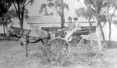
Photograph, 'Hillsboro' or "Hillsborough' - 6a Thistle Street, Surrey Hills, pre-1890
The photo was found behind a mantelpiece in the house at 6A Thistle Street while it was being renovated. It is thought to be of the first owner, Mrs Rachel Sweetnam (nee Lewis) and her husband, Thomas Edward Sweetnam. They were married on 24 September 1884 at St John's Church, Camberwell. REF: THE ARGUS 4 Oct 1884 Thomas second eldest surviving son of Matthew Sweetnam married to Rachel (Ray) third eldest daughter of Captain T.D. Lewis, Culm Haven, Camberwell. Thomas was active in land sales and variously described as a land agent, real estate agent and auctioneer. The property - Hillsboro or Hillsborough - was originally a house on a farm of 10 acres owned by her. It became 6A Thistle Street. According to the Alan Holt property register Rachel Sweetnam owned the property prior to 1890 and a family tree on Ancestry.com has that it was owned by her in c1886. It is likely that it was an investment rather than a family residence. Thomas Sweetnam was President of the Boroondara Shire 1888/89 and a councillor from 1886-1891. During his time as Shire councillor in 1887 he was charged with assaulting Charles A. Chandler, a window blind manufacturer, in response to an ‘insulting note’ left at Sweetnam’s house. Sweetnam was fined two guineas and 31 shillings. Sweetnam was also President of the Camberwell Gun Club from around 1890 – 91. In 1893 he relocated to Ferntree Gully, where he contested for the municipality’s North Riding council seat. Multiple references can be found on Trove. Note that the gentleman in this photo does bear a resemblance to Thomas Sweetman, President of Boroondara Shire in 1888-1889 found in the City of Boroondara Library Service mayoral portrait collection. No known photo of Rachel Sweetnam. Other property owners or residents are: 1890 Selina Gaylor 1900 Stephen Pullen 1910 William Murray (draftsman) 1920 George C Hughes 1930 Arthur Leslie Austin (tram driver) 1980 Mrs Lillian Evelyn Austin Sold in 1983 for $87,000. The house is still extant (January 2025). Note that we also have material / photos regarding George Hughes and family.This photo is one of the earliest photos of residences of Surrey Hills.Black and white photo of a woman and man in a buggy behind which is a simple house with a verandah at one end, surrounded by eucalypt trees.hillsboro, house names, thistle street, horse-drawn vehicle, clothing and dress, hillsborough, rachel sweetnam, rachel lewis, thomas sweetnam, selina gaylor, stephen pullen, william murray, george hughes, arthur austin, lillian austin -
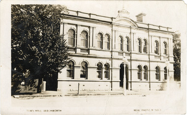 The Beechworth Burke Museum
Photograph - Postcard, Town Hall Beechworth, c1910
Beechworth Town Hall was designed by architects J.J. Coe and Thomas Dalziel and is dated to 1859. The building was made of granite and constructed to local builders Donald and William Fiddes. The original front to the building was replaced by a two story facade in 1889 designed by George Jobbins and built by Thomas Sandham according to a plaque on the front. The Town Hall is remarkable for its vaulted ceilings and columns. Originally the building was used as the Shire Offices but also doubled as a fire station and a courthouse, with still surviving cells underneath. Among the inmates was notorious bushranger Harry Power who was originally transported to Van Dieman’s Land for stealing a pair of shoes. He gained his freedom six years later but spent time in and out of gaol for the rest of his life for a variety of offences including a number of armed robberies. The Town Hall is now home to the Visitor Information Centre which helps visitors with amongst other things, accommodation, tours, event enquiries, and is the commencement point for Precinct walking tours. The Beechworth Town Hall is one of five distinctive granite buildings on Ford Street that comprise the Justice Precinct. It is of considerable historical significance as activity on the site dates from Australia’s gold rush period and was the administrative centre for north-eastern Victoria. The building has seen continual use from 1858 as an important public building and displays many aspects of the history of law enforcement in Victoria. The building is also of substantial architectural significance for its construction from local honey coloured granite, which also showcases early stone masonry techniques and craftsmanship. The Precinct is listed on the Victorian Heritage register and is protected by Heritage Victoria under the Victorian Heritage Act 2017. The buildings are also registered by the National Estate, the National Trust and protected by Indigo Shire Council’s Planning Scheme. Black and White rectangular postcard printed on cardReverse: 1906-1910?beechworth, beechworth town hall, town hall, jj coe, thomas dalziel, granite, beechworth historic building, courthouse, cells, geoge jobbins, thomas sandham, 1859, 1889, walking tours, beechworth historic precinct, historic precinct, harry power, bushranger, australian bushrangers, van dieman's land, transportation, armed robberies -
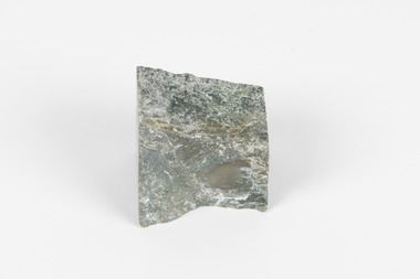 The Beechworth Burke Museum
Geological specimen - Greenstone, Hokitika Jade Company, unknown
New Zealand Greenstone, also called Pounamu is found on New Zealand’s South Island in riverbeds and boulders, and colours vary depending on the source, but always include green tones. It is a form of the mineral nephrite, also known as jade, and is a tough stone with a crystalline structure, made up of calcium magnesium and iron silicate. Its hardness means it is ideal for carving, and has been used for this purpose throughout history, especially by the Maori people of New Zealand. Greenstone features heavily in Maori mythology, and the traditional name for the South Island, Te-Wai-Pounamu, literally translates to waters of greenstone. Wearing of Greenstone pendants with different carvings is practiced by Maori to represent connection to land and ancestors, or to endow the wearer with certain attributes. The sticker on the base of the specimen identifies it as a product of Hokitika Jade Company. The company, which was active in the 1970s, sold jade and greenstone specimens and ornaments. Hokitika, which started life as an 1860s gold rush town, is the origin of most nephrite found in New Zealand, and the centre of the Greenstone carving industry. The object has scientific and research potential as part of the Burke Museum's Geology Collection, and as and example of New Zealand Greenstone. It also has spiritual significance for it's role in Maori beliefs and communities, where it is both traditionally worn and features in mythology. As a valuable stone regularly used in carving and jewellery, it has aesthetic significance. Sticker on base: "N.Z. Greenstone/ a product of/ Hokitika Jade Coy."geological specimen, geology, geology collection, burke museum, beechworth, new zealand, greenstone, hokitika, nephrite, jade -
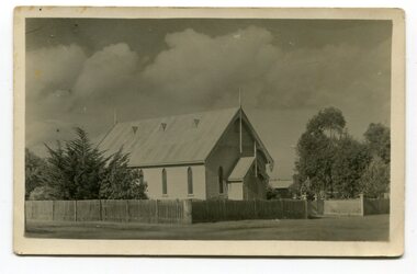 Orbost & District Historical Society
black and white photograph, Empire Post Cards, C 1940s
"The first Presbyterian Church service was conducted at the Orbost Station Homestead in 1885, during a visit by Sir William Clarke, who was accompanied by two ministers. The organist was resident Grace Jennings Carmichael. Services were later held in Mr J. W. Borland’s shop and the Mechanics Hall. In 1887, the land on which the church now stands was purchased from Mr James Hossack snr, for £50 ($100). The trustees were Mr John, Peter and Hugh Cameron, Mr John A Watt and Mr James Hossack Jnr. Timber from Richardson’s Tabbara Mill was used by builder Mr R. P. Cameron and at a cost of £311.3.7 ($622) the church was opened January 9th 1898." (from Newsletter 90 Margaret Smith) In 1928 the Sunday School hall was added to the church. Mr R.P. Cameron was the contractor for both the manse and the church. The first communion service was held on July 17 1892. the Presbyterian Church was commenced in Orbost in 1855 when the Reverend Chas Attwood was settled in pastoral charge.This is a pictorial record of the Presbyterian Church in Orbost as it was in the mid 20th century. It is now the Orbost Uniting Church hall, known as St Andrews Hall,A black /white postcard photograph of the Orbost Presbyterian Church, a wooden structure with a wooden picket fence at the front and trees on right and left sides. on back - " H Gap, Presbyterian Church Orbost"presbyterian-church-orbost religion -
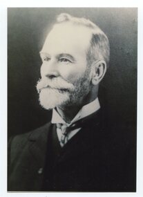 Orbost & District Historical Society
black and white photograph, late 19th / early 20th century
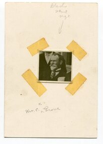
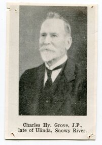
This is a photograph of Councillor Charles Henry Grove who represented South Riding on the Orbost Shire Council. from 1893 - 1901. He was president in 1893-1894, 1895-1896 and 1900-1901. He also served on the Tambo Shire prior to the formation of the Croajingolong / Orbost Shire. Charles Henry [Carl] Grove died on 17/4/1938 at Box Hill at the age of 88 and was buried in Orbost. Prior to coming to the Snowy River district, Carl worked as overseer on Buchan Station. In 1880, he selected land at Newmerella after first coming here in 1874 with early selector James A Robertson. He married Annie Robertson in 1876. Carl was a farmer, hop and seed grower and nurseryman. He was an elected Councillor of the newly formed Tambo Shire in 1882, and then in 1892 to the Orbost Shire where he served for many years filling various public roles. In 1911, he shifted to Queensland, but later returned to Victoria and died at Box Hill. (info. Newsletter 113)This item is associated with the Orbost Shire Council. The shire covered an area of 9,347 square kilometres and existed from 1892 until 1994 when it became part of the East Gippsland Shire Council. It is associated with Carl Grove, a prominent early Orbost citizen.A black / white head and shoulders portrait photograph of a bearded man in a suit. There is also a framed copy.grove-charles-henry grove-carl orbost-shire-council -
 Orbost & District Historical Society
black and white photograph, early 20th century
This is a photograph of Councillor Charles Henry Grove who represented South Riding on the Orbost Shire Council. from 1893 - 1901. He was president in 1893-1894, 1895-1896 and 1900-1901. He also served on the Tambo Shire prior to the formation of the Croajingolong / Orbost Shire. Charles Henry [Carl] Grove died on 17/4/1938 at Box Hill at the age of 88 and was buried in Orbost. Prior to coming to the Snowy River district, Carl worked as overseer on Buchan Station. In 1880, he selected land at Newmerella after first coming here in 1874 with early selector James A Robertson. He married Annie Robertson in 1876. Carl was a farmer, hop and seed grower and nurseryman. He was an elected Councillor of the newly formed Tambo Shire in 1882, and then in 1892 to the Orbost Shire where he served for many years filling various public roles. In 1911, he shifted to Queensland, but later returned to Victoria and died at Box Hill. (info. Newsletter 113Carl Grove was a prominent early Orbost citizen.A small square head and shoulders photograph of a man. It is attached to a white card with tape.on front - "Mr C. Grove"grove-charles -
 Mission to Seafarers Victoria
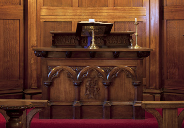
Furniture - Altar, Rodney Howard Alsop, 1907
Along with the pulpit, this Altar was designed by architect Rodney Howard Alsop (1881-1932) (Annual report 1908). It was originally made for the Siddeley Street Institute, which was built in 1907 on a block of land leased from the Melbourne Harbour Trust and donated by Mrs Amelia Shuter (nee Lord) (see Annual Report 1907). The altar is photographed in an early picture of the Siddeley Mission in a room used as chapel before the chapel built in 1909. Although a 21 year lease for the site had been granted, a notice was delivered to the Mission to quit the site in 1912. In 1915, the present site was agreed on. The Altar sits within the Chapel of Saint Peter, which belongs to the State Heritage listed (H1496) Mission to Seafarers Victoria complex. This complex was designed by Walter Richmond Butler in 1916, and officially opened on 11 September 1917. On the right hand side of the altar, is a brass plaque in memory of Charles Shuter, a colonist and police magistrate who died in 1902. The plaque was made in 1907.The Altar is significant because it is located within the Memorial Chapel of Saint Peter, forming part of the State Heritage listed Mission to Seafarers Victoria complex. It is of religious significance in catering for all denominations and the spiritual needs of visiting seafarers.The Altar has a shelf above and three panels along the front, with carved decoration and lettering. Altar bears a plaque that reads "To the Glory of God - In memory of Charles Shuter, of Melbourne, Police Magistrate, Given by his Wife, December 13th 1907". Carved letters "MTS" in centre of three panels along front of Altar, and "HOLY, HOLY, HOLY" in three panels below shelf on top of Altar.altar, mission, seafarers, seamen, melbourne, victoria, charles shuter, siddeley street institute, chapel, australian timber, walter richmond butler, australian maritime history, rodney howard alsop (1881-1932), saint peter chapel, communion table, amelia shuter nee lord, heritage listed, gifts-1917 -
 Orbost & District Historical Society
black and white photograph, late 19th century - early 20th century
This is a photograph of Councillor Charles Henry Grove who represented South Riding on the Orbost Shire Council. from 1893 - 1901. He was president in 1893-1894, 1895-1896 and 1900-1901. He also served on the Tambo Shire prior to the formation of the Croajingolong / Orbost Shire. Charles Henry [Carl] Grove died on 17/4/1938 at Box Hill at the age of 88 and was buried in Orbost. Prior to coming to the Snowy River district, Carl worked as overseer on Buchan Station. In 1880, he selected land at Newmerella after first coming here in 1874 with early selector James A Robertson. He married Annie Robertson in 1876. Carl was a farmer, hop and seed grower and nurseryman. He was an elected Councillor of the newly formed Tambo Shire in 1882, and then in 1892 to the Orbost Shire where he served for many years filling various public roles. In 1911, he shifted to Queensland, but later returned to Victoria and died at Box Hill. (info. Newsletter 113)This item is associated with Carl Grove, a prominent early Orbost citizen.A small black / whitee head and shoulders photograph of a man with beard and moustache, He is wearing a suit and tie.grove-charles -
 Orbost & District Historical Society
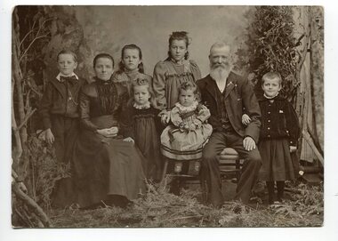
black and white photograph, C1906
This is a photograph of John Draffin and his family. John Draffin was for a time the Orbost Shire Secretary. John Draffin came to Australia as a child with his parents from the north of Ireland . He came to Orbost in 1894 and was Shire Secretary from then until 1910 He had four children: Andrina, Eva, George, Maggie, Sally and Nellie. "Mr Draffin was 67 years of age when he died. He had for many years been engaged in farming pursuits, and at one time held the position of champion plough- man of Victoria. In his younger days he used to make it his boast- that although he was a small man he could do as much work as a big one Some thirty odd years ago be took up land in South Gippsland, but in 1895 gave up farming, and was appointed secretary to the Orbost shire, a position which he held until he was compelled by failing health to resign." - from Snowy River Mail 1 August 1912.John Draffin was a prominent Orbost citizen involved in many community activities.A black / white studio photograph of a family - mother father and six children. The parents are seated with the youngest child, other children are standing.draffin-john orbost-shire-secretary -
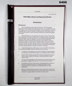 Bendigo Military Museum
Administrative record - DIGO Map Library and Repromat Review 2004, Geospatial Analysis Centre, Bendigo, 25 Oct 2004
Prior to the digital revolution the only medium by which cartographic information could be reproduced and distributed on mass was via printed media. The final negatives (repromat) used to produce the printed products were the culmination of a complex cartographic process and were therefore carefully preserved and stored. Preservation of the so-called final negatives enabled subsequent reprinting with minimal cartographic intervention. Since the arrival of the Land Headquarters Cartographic Company at Fortuna in 1942 the repromat for all products produced by the Australian Survey Corps were carefully stored. With the disbandment of the Army Survey Regiment in 1996 the Defence Imagery and Geospatial Organisation (DIGO) inherited that repromat archive. It was immanent that the support for film based printing was ending so on 25 October 2004 a review was required to determine the way ahead for the repromat and paper maps stored in the DIGO Map Libraries. Most of these maps were produced by the Royal Australian Survey Corps. This report is the result of that review. The report recommends the disposal of the repromat and the retention of single map copies. A4 plastic covered report, plastic clip bound, front page clear and rear page red. 9 x page document about the future of repromat and map printing.royal australian survey corps, rasvy, fortuna, army survey regiment, army svy regt, asr -
 Warrnambool and District Historical Society Inc.
Certificate, Death Margaret Bostock 1919, 1989
Augustus Bostock was the 9th child of Robert & Rachael Bostock of Vaucluse Epping Forest, Van Diemen’s Land. He was only 4 years old when his mother died. He was inspired by his father to seek his fortune in the Western District of Victoria. He arrived around 1850. He married Margaret Aitkin in July 1865. Augustus owned several properties in the district and leased others. He sat on the court of Warrnambool, Mortlake or Hexham as required. He resided at Marramook in Hawkesdale and later moved to Vaucluse in Hopetoun Road Warrnambool, where he died in 1920 at the age of 87. He was involved in many aspects of life in the Western District, racing, cricket, and social activities to name a few. This death certificate is for Margaret Bostock, the wife of Augustus Bostock. She was the daughter of James and Mary Aitkin and one of three sisters to marry three of the Bostock brothers. Margaret and Augustus had six children, Jane, James, Ernest, John Augustus, Mary and Rachel. Margaret died in 1919. This is one of a number of documents which relate to the Bostock family who were one of the most important pioneering families of the Western District. They owned and leased various properties around Warrnambool and were involved in many aspects of social and business life. This death certificate of Margaret provides family history information.Rectangular white paper overprinted with light green pattern stating State of Victoria. Blue stamp dated 16 Mar 1989. Dated 1919 in top left corner. Typed form filled in in black handwritingRegistered by Robert R Macfarlane, date stamped 16 Mar 1989. Extract no 15370.bostock, warrnambool, margaret bostock -
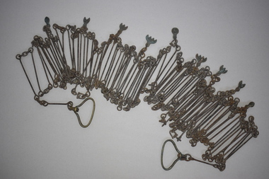 Warrnambool and District Historical Society Inc.
Chain link measure, Gunter's Chain, 19th Century
A Gunter’s Chain, an old land surveying instrument, is named after its inventor, Edmund Gunter (1581-1626), an English mathematician and astronomer. It was first produced in 1620. The tool has 100 links and is 66 feet or one chain long. The links are marked off in groups of ten by metal tags or rings. A quarter chain (25 links) is called a rod or pole and ten chains make a furlong and 80 chains a mile. The traditional cricket pitch is 22 yards or one chain long. This chain is said to have been used by Gilbert Nicol when the Warrnambool to Hamilton Road was constructed in the 19th century. Gilbert Nicol was an early settler in Warrnambool who, with John Craig, established the first hotel (and the first building) in Warrnambool in 1847. Nicol later owned the property ‘Rosehill’ in the Warrnambool area. As the chain was given to the Warrnambool and District Historical Society by the Town Clerk, Keith Arnel, it is likely that the chain was one of the items in the old Warrnambool MuseumThis Gunter’s Chain is of importance because it is an early land measuring device that was used for over 250 years and has great historical and mathematical significance. If it is correct that it was used by Gilbert Nicol when the Warrnambool to Hamilton Road was built then it has considerable local significance and dates back to the 19th century. This is a metal tool which consists of 100 metal pieces or links joined together by loops at each end with two metal loops in between each link. The links joined together form a chain. The two ends of the chain have small metal handles attached. At intervals along the chain there are additional rings or metal pieces attached. The metal is very rusted.gunter’s chain, land measurement tools, history of warrnambool -
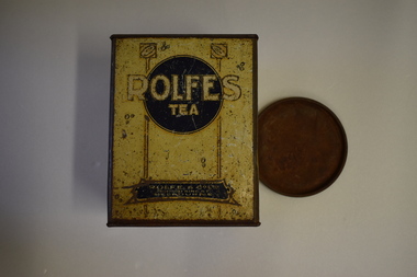 Warrnambool and District Historical Society Inc.
Tea Tin (Rolfe), Artefact, Early 20th century
This is a tea tin from the business of Rolfe and Co., a wholesale grocery and importing business founded in Melbourne in 1854 by George Rolfe Senior, a merchant and politician. George Rolfe died in 1871 and the business was then run by his son, George Rolfe, Junior. The business continued until at least the late 1930s. George Rolfe (1836-1919) was a keen sportsman and he began holidaying in Warrnambool for some years in the 1870s when he started buying land in the area. By the early 1880s Rolfe owned 50 acres in Warrnambool and established his holiday residence at Lyndoch near the mouth of the Hopkins River. He improved the original site with the addition of a large garden, stables, jetty, boatshed, water well, chaff and bone sheds, reservoir etc and bought other properties including Shipley on the Allansford Road and the adjoining property Fairy Hill. He continued managing the Rolfe and Co. business in Melbourne until his death in 1919. Today Rolfe’s Lyndoch property in Warrnambool is the site of an aged care facility. This tin is of considerable significance as it is a memento of George Rolfe who established the property of Lyndoch in Warrnambool and was a prominent land holder in the late 19th and early 20th centuries. (Note that we have another Rolfe tea tin but it is in very poor condition compared to this later acquisition). This is a rectangular-shaped tin with four sides originally painted yellow but now showing considerable rust. The printing on the sides is brown and white, some on a blue background and some surrounded by decorative patterns.No. 2 Rolfe & Co. Ltd 286-300 King St. Melbourne Rolfe’s Tea Rolfe and Co. was established at Melbourne in 1854. Ever since then it has enjoyed an enviable reputation as a firm which supplies to the public goods of the highest quality. george rolfe, lyndoch warrnambool, rolfe & co, importers, melbourne, history of warrnambool -
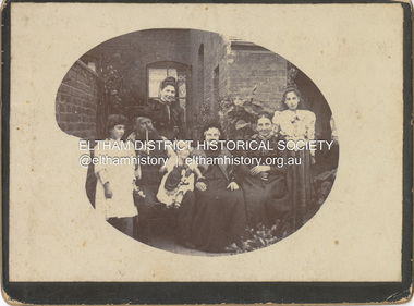 Eltham District Historical Society Inc
Photograph - Cabinet Photograph, William Ingram family, Birmingham, England, c.1880
William Ingram with possibly his wife Pamela Thomas and family members. William is second from left with pipe, the others unidentified. The family lived in Birmgham, England. William, a baker died in 1905. William and Pamela had six children; William George Grove (1861-1939), Elizabeth (1865), Evan Thomas (1867-1956), Joseph (1868-1934), Louis (1870-1941) and John (1872-1958). John Ingram learnt his trade from his father but following a quarrel with his father, he ran away and worked his passage to Australia as a ships baker. His elder brother Evan was already in Australia living in Malvern. It was here that he met Ada Key. John and Ada were married in Fremantle, Western Australia. They travelled to England then Cape Town, a family already started. They returned to Melbourne and in 1901 bought land at Research where he worked to establish an orchard and worked at night asa baker in Eltham. The fashion and hairstyles appear trypical of around 1880ingram family, birmingham, william ingram, baker, pam thoonen (nee ingram) collection -
 Eltham District Historical Society Inc
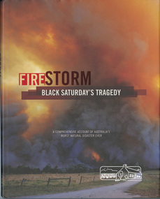
Book, Glenvale School (Lilydale, Vic.). Committee of Parents and Friends, Firestorm : Black Saturday's Tragedy, 2009
This book is dedicated to all who lost so much on the darkest Saturday in Australia's history. Australia's worst natural disaster was a tragedy beyond belief that scarred Victoria physically and the whole Australian nation physiologically. Extreme temperatures, tornado-like wind speeds and tinder-dry land, culminated in the disaster we now know as Black Saturday. Before the sun would set on the blackest day in Australia's history, thousands of hectares would become blackened landscape and an unparalleled loss of lives could only mean that many areas would never be the same again. This graphic pictorial record takes you through the conditions prior to the day, the horrific fires that destroyed both bush and townships alike, the amazing bravery of emergency services personnel and the tragic aftermath. Accounts from eye-witnesses describe a fire like never seen before, a wild fire that outran every warning system. "A comprehensive account of Australia's worst natural disaster ever"black saturday, bush fires, bushfire, fire damage - buildings, victorian bushfires - 2009 -
 Phillip Island and District Historical Society Inc.
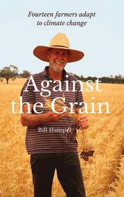
Book, Bill Hampel, Against the grain : fourteen farmers adapt to climate change, 2015
Can we humans simply ignore the fires, the floods, and the increase in deaths brought about by climate change? In this book, Australian farmers - who bear the brunt of climate change, yet accept the science - share their experiences with the unpredictable weather events, the reduction in rainfall, and the shift to hotter months which are a challenge to farming cycles. Far from contributing to the problem with their farming practices, these farmers demonstrate how to reduce their greenhouse gases - to zero or below in some cases - while remaining profitable. They are all committed to pass on their farm in a better condition than when they first purchased or inherited it. With crops or livestock, big or small, they have worked cooperatively, mostly through land management, to plant thousands of trees, which has led to the daily presence of over 100 bird species. The farmers' inspiring and informative stories will open up a new world to most urban dwellers. A summary of climate change impacts - and an account of the numerous economic, political, and media barriers toward change - combine to provide a context for their work. 280 pages : colour illustrations, colour maps, colour portraits ; 23 cm. Includes bibliographical references and index. Also available in digital formats: ebook & epdf. ISBN 9781925078503 Dewey number 338.10994 Chapter 5 : Bob & Anne Davie Donor : Anne Davie ; Date : 14.10.2015.agriculture -- environmental aspects -- australia., farmers -- australia -- economic conditions., rural development -- australia., climatic changes -- australia. -
 City of Moorabbin Historical Society (Operating the Box Cottage Museum)
Document,photocopy plan 'Two Acre Village 'c1852, c1960
In the 1852 Josiah Holloway, a developer, purchased 625 acres from the squatters Richard and John King and sectioned '2 acre allotments' south of Henry Dendy's Brighton Survey along the Arthur's Seat Road ( later Nepean Highway) for sale @ £10 It became known as The Two Acre Village as settlers took up the allotments and established market gardens, general stores, butchers, blacksmiths, post office and 2 hotels. Charles Whorral opened The Cheltenham Inn and it became so popular as a meeting place that the area was called Cheltenham. The early settlers, who were predominantly English and Scottish immigrants initially leased their allotments and, because the sandy soil was so fertile, they were soon able to purchase the land and increase their acreage. Cheltenham became a very important part of the large Moorabbin Shire1871 and City of Moorabbin 1934 In the 1994 Amalgamation of Councils, when the large City of Moorabbin was divided between the newly formed Glen Eira, Kingston and Bayside Councils, the Cheltenham area was assigned to the City of Kingston A photocopy of the Plan for the 2 Acre Village in Moorabbin Parish c1852. A3 laminatedmoorabbin, brighton, cheltenham, market gardeners, pioneers, early settlers, , king. john, holloway josiah, whorral charles, arthur’s seat road, nepean highway , cheltenham inn hotel, henry dendy special survey 1841 -
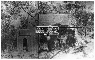 Eltham District Historical Society Inc
Negative - Photograph, Eltham - Old R.C. Church (building not there in 1923)
Eltham - Old R.C. Church (building not there in 1923). The original St Mary’s Roman Catholic Church (1865-1912) was built of clay brick with buttress walls and a slate roof on the corner of Fordhams Road and Maria Street (Main Road), Eltham South, opposite the present-day Wingrove Park. It was blessed on September 3, 1865. With the arrival of the railway in 1901 and the town centre moving closer to the station, the decision was made to relocate the site of the church to its present-day location on Henry Street at the corner of Main Road. A new timber weatherboard church, also called St Mary's was erected and blessed on October 13, 1912. The church and land cost £1,400 (Evelyn Observer). The original brick church It was demolished in the 1920s and the bricks and windows were recycled to build a dairy on the Brinkkotter farm at Research. The timber church was destroyed by fire in 1961 and a new modern architectural (1960s) style church was erected in its place and named Our Lady of Help Christians Church.This photo forms part of a collection of photographs gathered by the Shire of Eltham for their centenary project book,"Pioneers and Painters: 100 years of the Shire of Eltham" by Alan Marshall (1971). The collection of over 500 images is held in partnership between Eltham District Historical Society and Yarra Plenty Regional Library (Eltham Library) and is now formally known as the 'The Shire of Eltham Pioneers Photograph Collection.' It is significant in being the first community sourced collection representing the places and people of the Shire's first one hundred years.Digital image 4 x 5 inch B&W Negsepp, shire of eltham pioneers photograph collection, eltham, roman catholic church, catholic church, church, main road, st marys catholic church