Showing 77 items
matching agricultural activity
-
 University of Melbourne, Burnley Campus Archives
Document, Victorian College of Agriculture and Horticulture, Pruning Garden, 1995
pruning garden, field station, orchard, vcah burnley, horticultural resources area, student gardens, ground cover plots, students working poutside, plan -
University of Melbourne, Burnley Campus Archives
Booklet (item) - Prospectus, Burnley Gardens Prospectus School of Horticulture School of Primary Agriculture, 1918?
burnley gardens, advanced certificate in horticulture -
Bacchus Marsh & District Historical Society
Plaque, Shire of Bacchus Marsh Coat of Arms
... of arms also depict key economic and agricultural activities ...Coat of Arms used by the Shire of Bacchus Marsh in the 1980s and 1990s. A coat of arms has been in use in the Shire at least from the early 20th century. This earlier coat of arms described in 1910 featured two cows standing on two bales of lucerne hay, with lucerne fields and fruit trees and rolling hills all round a central valley with two rivers running through it. This early coat of arms was superseded by the slightly different design shown here. When this change took place is not known. When the Bacchus Marsh Shire amalgamated with other Shires to form Moorabool Shire in 1994 this design was superseded.The plaque showing the Bacchus Marsh Shire Coat of Arms is in near perfect condition and as such is an excellent example of the physical symbols used to demonstrate the presence of local government in the Bacchus Marsh region. The images on the coat of arms also depict key economic and agricultural activities in the region which provides historical information about the region in a visual and artistic way.Painted cast bronze plaque with inscription on outer white band in black capital lettering: SHIRE OF BACCHUS MARSH. Inner circle painted blue with shield and decorative branches bearing yellow leaves on either side. Shield quartered and surmounted by stylised sunrise. In four quarters, representations of significant local primary and secondary industries. SHIRE OF BACCHUS MARSH.coats of arms, shire of bacchus marsh -
 Wodonga & District Historical Society Inc
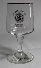
Memorabilia - CWA Wodonga Golden Jubilee Wine Glass, 1984
The Country Women’s Association of Victoria was formed 12 March 1928 and today has over 5,600 members. Its original aim was to improve conditions by community service, more especially as they affect the welfare of women and children. The Wodonga CWA branch was formed in 1934 and has been an active group in the community until the present day. The CWA provided gathering opportunities for rural women and quickly became renowned for their street stalls, catering at Agricultural Shows and social events including debutante balls, handicraft classes and cooking demonstrations. Today they have become even more than that, participating in and organising a wide range of activities and initiatives in the community, always with the focus of service to others. The CWA is of significance on a local, state and national level as a critical service group. They conduct a range of social, educational and services throughout Australia with an initial focus on the support of rural women and children. This role has evolved over time to incorporate a wide range of initiatives, government advisory bodies and organisations.A wine glass decorated with a gold rim and gold logo of the CWA Victoria produced to celebrate the golden jubilee of the Wodonga BranchAbove the CWA logo "GOLDEN JUBILEE" Beneath the logo "WODONGA/1934 - 1984"country women's association, wodonga cwa, service groups, community organisations -
 Sunbury Family History and Heritage Society Inc.
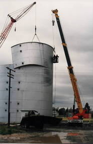
Photograph, Wheat silo, c1984
... was dismantled and removed. Cereal growing was one of the agricultural ...A wheat silo was erected on railway land adjacent to the Sunbury Station in 1967. Frank Millett handled the operations. As bulk handling was the preferred way to transport wheat, the silo gave local cereal growers to deliver their grain to the railhead. Over the years of the operation 200 grain wagons delivered wheat annually to the silo. In 1984 the silo was dismantled and removed.Cereal growing was one of the agricultural activities carried out in the Sunbury and surrounding areas for many years.A non-digital coloured photograph of a metal wheat silo being dismantled. A crane is beside the silo and two men are suspended from the crane in a basket to ensure that the sheets of iron land safely on the truck. wheat storage, silos, frank millett, cereal crops, sunbury railway station -
 Linton and District Historical Society Inc
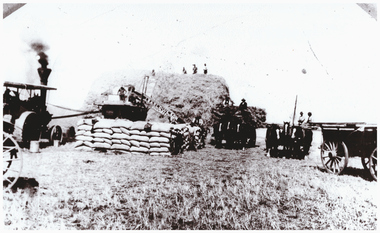
Photograph, Harvesting at Mannibadar
... Mannibadar Rural activity Agriculture Farming Harvesting ...Two black and white copies of an original photograph which shows grain harvesting at Mannibadar. On the left of the photograph is a traction engine which is being used to operate a mechanical thresher. In the centre of the photograph are filled and stacked sacks of grain. Two horse-drawn wagons are to the right of the photo. The conveyor taking the grain from the threshing machine to the ground where it is being bagged has "J. Barlow & Son Ballarat" across it in large letters.mannibadar, rural activity, agriculture, farming, harvesting -
 Linton and District Historical Society Inc
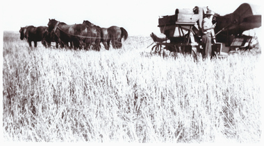
Photograph, Norman Ellis Harvesting on the Lewers Property at Mannibadar, 1947
... Mannibadar Agriculture Farming Rural activity Harvesting ...Black and white copy of original photograph which shows horse drawn harvesting machinery being operated by Norman Ellis on a property at Mannibadar owned by the Lewers family.On front: "Norman Ellis harvesting on Lewers". On back: "G. Ellis" / "Norman Ellis harvesting on Lewers 19476".mannibadar, agriculture, farming, rural activity, harvesting, norman ellis, lewers family -
 Eltham District Historical Society Inc
Photograph - Digital Photograph, Alan King, Golden King Mine poppet-head, Yarrambat Primary School, 1 February 2008
The Golden King Mine poppet-head stands at the school’s Yan Yean Road exit gate. Published: Nillumbik Now and Then / Marguerite Marshall 2008; photographs Alan King with Marguerite Marshall.; p23 Early Yarambat - Tanck's Corner Its early settlers, who in the 1840s were amongst the first non-Aboriginal people in the area, found life tough as they grazed their sheep and cattle. Yarrambat was then known as Tanck’s Corner or Reynolds Corner, after wood carter, Frederick Tanck, who owned land north of Ironbark Road, at the corner of Yan Yean Road, and Thomas Reynolds, owner of the opposite property. After Reynolds sold his land, the corner became known as Tanck’s Corner. In 1929 the district’s name was changed to Yarrambat, believed to mean ‘high hill’ in the Wurundjeri language. Tanck’s Corner was in the centre of gold-bearing country and the district is honeycombed with old tunnels and shafts. However although gold played a dominant role for decades, there was insufficient to develop a substantial township. Meat and agricultural produce made a greater impact. Until the mid-20th century the only substantial building was the primary school. The first gold rush occurred around 1860, the second after 1900; then during the Depression, the Government paid men to pan for gold. The first rush attracted hundreds of Chinese people to Smugglers Gully, who constructed round diggings to keep away spirits. Alluvial miners lived along the Plenty River in tents or humpies - some fenced with gardens - and some miners distilled their own ‘plonk’. It was a wild time and bushrangers - and later gangster Squizzy Taylor - were said to hide4 in the old Pioneer Tunnel in Dunne’s Gully between Heard Avenue and Pioneer Road. Mines opposite Tanck’s Corner included Beer’s Line, Golden Crown and Golden Stairs. Some of the big mines had batteries and stampers to process quartz. At first there was plenty of alluvial gold, as much as two ounces to the ton. At times gold was exposed after heavy rains so fossickers panned for gold around orchard irrigation trenches. Gold was mined until 1984 when Yarrambat’s last operating goldmine, the Golden King Mine, in North Oatlands Road, closed. The Clayton family operated it full-time, making a comfortable living and in the 1960s it was the only private family gold mine in Victoria.5 Gold was such an important part of Yarrambat’s history that a gold poppet-head is the Yarrambat Primary School’s logo. The Golden King Mine poppet-head stands at the school’s Yan Yean Road exit gate. However this school was built in 1988. The original school No 2054, at the corner of Ironbark and Yan Yean Roads, was opened in 1878 and modified to its present form in the 1920s. In 2000 it was relocated to the Heritage Museum at Yarrambat Park.7 The school, whose first head teacher was Charles Planner, consisted of one room with a three-roomed residence. The school was also the community centre. On Saturday nights it was crammed for dances or euchre parties, community singing or other social events. On Sundays, services for different denominations took turns each week. However the school had its teething problems. Parents accused Charles Planner of neglecting his duties and the school closed several times. When it closed in 1892, only church services continued. Social activities moved elsewhere, such as the tennis club to the Stuchbery tennis court opposite. A sports day and woodchop on Boxing Day around 1900 was held at the Evelyn Hill Hotel, also called Evelyn Arms and Tunnel Hill Hotel, on the Greensborough–Diamond Creek Road. An annual agricultural show in Diamond Creek paraded through the town, and New Year’s Day picnics at the Yan Yean Reservoir included highland dancing and competitions. Also popular were the Indian hawkers who visited every three months, selling trinkets, clothing and other items. One called Jimmy ‘Allem dem Bedi’, gave presents and told stories, played draughts and sold delicious curries he cooked over his camp fire at night.This collection of almost 130 photos about places and people within the Shire of Nillumbik, an urban and rural municipality in Melbourne's north, contributes to an understanding of the history of the Shire. Published in 2008 immediately prior to the Black Saturday bushfires of February 7, 2009, it documents sites that were impacted, and in some cases destroyed by the fires. It includes photographs taken especially for the publication, creating a unique time capsule representing the Shire in the early 21st century. It remains the most recent comprehenesive publication devoted to the Shire's history connecting local residents to the past. nillumbik now and then (marshall-king) collection, golden king mine, tanck's corner, yarrambat primary school -
 University of Melbourne, Burnley Campus Archives
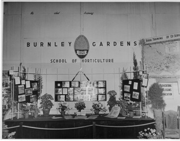
Photograph - Black and white print, Royal Show 1957, 1957
Note by T.H. Kneen 13 May1992, "The Burnley display was part of the Division of Agricultural Education's display covering Dookie, Longerenong and Burnley. Reference to Rural Training in 1957 would have been mainly to the on-farm training phase of the Rural Reconstruction Training Scheme. The Agricultural Collegians Association members had a meeting point at the exhibit. Burnley ex-students were not members of that association."Black and white photograph. Display mounted by Burnley Gardens School of Horticulture at the Royal Agricultural Show 1957. Incorporates photographs of College activities, horticultural information and a map of Victoria locating institutes offering rural training to ex-servicemen.On reverse, "Royal Show 1957."burnley gardens, school of horticulture, royal agricultural show, dookie college, rural training, rural reconstruction training scheme, the agricultural collegians association, horticulture, publicity, dept of agriculture education division, longerenong college -
Lakes Entrance Historical Society
Book, Wellings, H.P, Benjamin Boyd in Australia (1842-1849), 1935
Brief history of Boyd's years in Australia, particularly his connection with Boydtown in Eden and the whaling industry, but including information on his pastoral activities and other interests.settlers, whaling industry, ships and shipping, agriculture -
 Linton and District Historical Society Inc
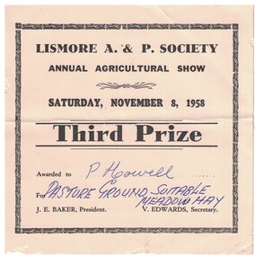
Prize Certificate, Lismore A. & P. Society Annual Agricultural Show, Third Prize, P. Howell, 1958
Awarded at the Lismore A. & P. Society Annual Agricultural Show to Percy (Ronald Percival) Howell of Mannibadar, for Pasture Ground Suitable Meadow Hay. Event was held on Saturday, November 8th, 1958. Percy (Ronald Percival) Howell farmed Corriedale and Merino sheep on his property at Mannibadar. His sons were Ray, Ron and Mervyn (who was killed in action in the last days of World War II).Cream cardboard prize certificate with black printed text. Text: " LISMORE A. & P. SOCIETY / ANNUAL AGRICULTURAL SHOW / SATURDAY, NOVEMBER 8, 1958 / Third Prize. "lismore a. & p. society, percy (ronald percival) howell, prize certificates, prize ribbons, rural activity, lismore a & p show -
 Buninyong & District Historical Society
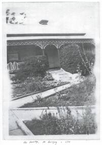
Photograph - Black and white copies of photographs of "The Hermitage", Photographs of "The Hermitage" home of the Poynton family
... the Church and its activities for many years. This home represents ...The Poynton family arrived in Buninyong in 1896 and established a property in Warrenheip Street followed by the purchase of "The Hermitage" on the slopes Mount Buninyong for the succeeding generations to supply cream, potatoes, pigs, peas and gooseberries to the local community. Silas Poynton was appointed a Trustee of the Buninyong Methodist Church in 1914 and family life revolved around the Church and its activities for many years.This home represents the life of the early families in the district, their agricultural activities and their community links. Various views of "The Hermitage" circa 1920s and a copy of the contract for the purchase"The Hermitage" Mt. Buninyong c. 1920poynton family, "the hermitage", mount buninyong, methodist church -
 Narre Warren and District Family History Group
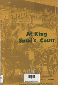
Book, FC Hooper, At King Spud's Court: the story of the Kooweerup Potato Festival's first ten years (1972-1982), 1982
A chronicle of the first decade (1972–1982) of the Kooweerup Potato Festival in Victoria, Australia. It delves into the history, community involvement, and cultural significance of this unique festival, which celebrated the region's rich potato farming heritage.108 p.; 22 cmnon-fictionA chronicle of the first decade (1972–1982) of the Kooweerup Potato Festival in Victoria, Australia. It delves into the history, community involvement, and cultural significance of this unique festival, which celebrated the region's rich potato farming heritage. koo wee rup potato festival, koo wee rup (vic.), kooweerup (vic.) -
 Sunbury Family History and Heritage Society Inc.
Photograph, Hay shed, c1960s
... being transported. Cereal growing was one of the agricultural ...The hay shed was sited on railway land fronting onto Evans Street and near Station Street. Retail shops including Harris Scarf now occupy the site. The pine trees in the background were along Horne Street.The hay was stored in this building before being transported.Cereal growing was one of the agricultural activities carried out in the Sunbury area.A scanned print of an old black and white photograph of a corrugated shed with hay bales stacked at the rear of the building. A 1960s sedan car is parked in front of the building and there is a smaller shed in the background.hay shed, railways, sunbury station, evans street, horne street -
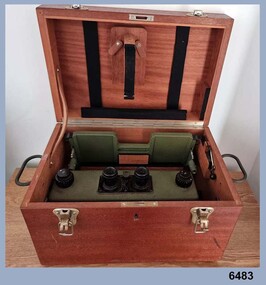 Bendigo Military Museum
Instrument - Old Delft Scanning Stereoscope ODSS III, C. 1956
This is a superbly crafted cartographic mapping instrument. It is housed in its own high-quality purpose-built oak box. Made in the Netherlands from 1950 onwards. This instrument is from c 1956. it is a very high-quality military grade stereoscope that was generally used by photographic interpreters such as intelligence analysts but was equally useful for mapping activities. The stereoscope was used to examine 3D aerial photographic images. This instrument has a particularly useful capability to scan over the 3D stereo model using X and Y movement knobs, rather than having to physically move the aerial photographs. In the public and private sector it was also useful for photogrammetric interpretation for Forestry and Agricultural purposes. See also Bendigo RSL Collections Victoria item Number 6205.6P that shows the Old Deft Stereoscope in use at the Army Survey Regiment, Bendigo.This is an "Old Delft" scanning stereoscope with its reflecting carriage and legs. The Stereoscope is housed in its own purpose built wooden oak box that has dovetail joints, 2 x securing clips, 2 x handles and a lock (without key). The instrument is assembled by inserting colour coded legs into their matching slots."OLD DELFT SCANNING STEREOSCOPE ODSS III" "Patents Applied for" "OLD DELFT C4790" "MADE IN THE NETHERLANDS"royal australian survey corps, rasvy, fortuna, army survey regiment, army svy regt, asr -
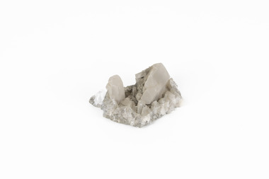 The Beechworth Burke Museum
Geological specimen - Calcite crystals
Calcite is a common mineral and is found worldwide due to it being a primary component of many other rocks such as limestone and marble. It is a softer mineral that scratches easily and is often found colourless or with a cream/white shade but may show up in colours such as red, yellow, green, and violet. In sedimentary rocks calcite is often found in the form of invertebrate shells, making it an important biomineral. Calcite is used in many industries such as farming, building, and medicine. This particular specimen was found at Broken Hill mine in Broken Hill, New South Wales, Australia. Broken Hill mine is one of the largest mines working silver and lead in Australia and at its peak employed 6500 staff across 7.5km long of land. The site was founded in 1883 by Charles Rasp, where Rasp and 6 other men from various backgrounds came together to form the first BHP mine. It has become one of the most popular mining sites due to its abundance and longevity. The ore body was created 1685 million years ago due to volcanic activity causing heated seawater to flow up through the seafloor where it mixed with the cold water creating black sulphide precipitates. These then settled back onto the seafloor forming sediment layers rich in minerals. Over time the land eroded until it was discoverable by humans.Historically this specimen is significant due to the origin of its location. Broken Hill mine has a long history in both its location and its findings and has resulted in a variety of minerals being discovered at its site. It is beneficial in the understanding of the Australian landscape over millions of years. Due to its properties, calcite today is used in a multitude of different industries such as agriculture, construction, medicine, and farming.A small sized calcium, carbon and oxygen made mineral specimen in shades cream and greycalcite, mineral, limestone, marble, sedimentary, invertebrate shells, biomineral, farming, medicine, broken hill, broken hill mine, new south wales, charles rasp, syndicate of seven, volcanic activity, black sulphide precipitates, calcite crystals, beechworth museum, indigo shire, beechworth -
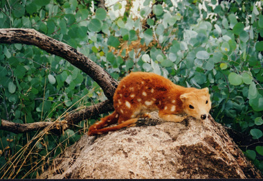 Wooragee Landcare Group
Photograph, 27th February 2004
... , creates a picture of Victorian agriculture, trade, and community ...Photograph of Quoll taxidermy, part of the Quoll presentation at the Wooragee Hall on Friday, 27th February, 2004 as part of an event called Foxy Night Out. Foxy Night Out is part of a land fox control project. This workshop is conducted to help private and public community members to understand foxes and effective fox control techniques, and its impact to agriculture and other animals. Quolls are carnivorous marsupials native to Australia and New Guinea. They grow up to 125cm and weighs up to 5kg. The spotted-tail Quoll is now the largest carnivore on the mainland. Quolls have black to fawn fur, white spots, long and thin tails. Quolls can attack livestock like chickens. They are known for sharp teeth that enables them to sustain a diet that involves poultry meat. They hunt for their families. Historically, Quolls are treated as pests and were trapped or poisoned by people who are protecting their chickens.This photograph contributes to the scientific and historical records on fox control in Victoria. It reflects the effects of foxes and quolls to livelihood, thus, creates a picture of Victorian agriculture, trade, and community activities. Coloured rectangular photograph printed on matte photographic paperReverse: WAN NA / 0ANA2N0 BN2+ 2 1636 / (No. 5) 919foxes, quoll, landcare workshop, taxidermy, ecosystem, fox control project, agriculture, fox, marsupials, carnivore, pests