Showing 170 items
matching contour
-
 Bendigo Historical Society Inc.
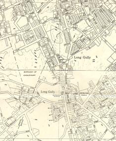
Map - LONG GULLY HISTORY GROUP COLLECTION: MAP OF LONG GULLY AREA
BHS CollectionMap of Long Gully area printed on yellow paper. Map shows Eaglehawk Road from Don Street to Weatherall Street, then Mt Korong Road to Dowding Street. Some contour lines on the map.bendigo, history, long gully history group, the long gully history group - map of long gully area, borough of eaglehawk -
 Kiewa Valley Historical Society
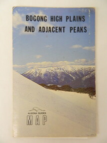
Map - Bogong High Plains & Adjacent Peaks x2, 1976
This map was produced as a result of the 'pressure from walkers' who are interested in climbing the accessible peaks on the Bogong High Plains. Places, huts and rivers are named and indexed. Contours are not given. Heights of mountains are in metres.The Bogong High Plains is a popular walking area and a National Park. This map identifies the mountains and peaks in the area at the time of publication. Some of the huts have since been destroyed by fire and Mt Niggerhead has since been renamed to Jaithmathang.Blue and white cardboard folded in half containing a folded black and white map of Bogong High Plains and Adjacent Peaks with index.bogong high plains. mountains. bushwalkers. walking. map. national park. recreation. cycling. tourism -
 8th/13th Victorian Mounted Rifles Regimental Collection
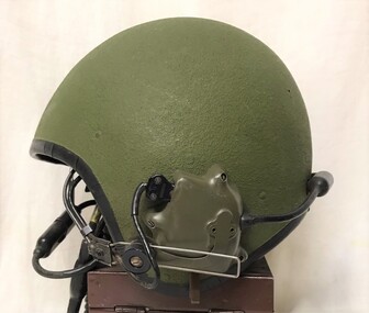
Headwear - Crewman helmet
Kevlar ballistic shell coated with walnut flour covering, contoured to fit liner containing communications headphones. Worn by Major Ian Docking OC ‘A’ Squadron 8/13 Victorian Mounted Rifles.Crewman's helmet with incorporated headphonesOC / Dockinghelmet, docking, vmr, armour -
 Bendigo Military Museum
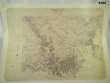
Map - Australian Topographical Survey SYDNEY / 56III Southern Half, NE Plane Table Field sheet 1915, Australian Survey Corps, 6 Dec 1915
This is a unique example of a hand drawn plane table sheet produced in the first year of the Australian Survey Corps by original members of the Corps. Roseblade and Lynch 5 Dec 1915. Of interest is the documented times that it took to create the original field sheet. Also of interest is the fact that this field sheet that was used to create the actual SYDNEY map sheet was contoured, many map sheets produced up until now were purely planimetric and lacked contouring that was needed for military use. This is a reproduction print of a photograph of the original field sheet and was printed at the Army Survey Regiment, Bendigo.Reprinted coloured Image of Australian Topographical Survey SYDNEY /56 III Southern Half, hand drawn NE Plane Table field sheet. Includes an itemized summary of work performed by HA Roseblade CSM Australian Survey Corps 1915, Signed by J Lynch Lieutenant.royal australian survey corps, rasvy, fortuna, army survey regiment, army svy regt, asr -
 Bendigo Military Museum
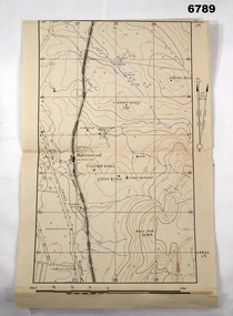
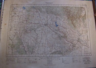
Map - MAP, RAVENSWOOD, VIC TRAINING AREA, Aust Army, Unknown
Items in the collection re Lt Col J. Swatton, refer Cat No 6719.2P for his service details.This is an enlarged version of a contour map. It is undated. On centre left is Ravenswood Train station. The Calder Highway is shown, from the bottom of the map to halfway up left side. Top right side shows "Spring Hill".Each grid square is 1000 x 1000 yards. Top right corner grid is 230,000 E, 450,000 Nth. Magnetic variation when this map was made is 6.55' grid to magnetic Nth. printed onto the map, with an "X" are 'Starting Point', "Debussing Point", and "Assembly Point" . Handwritten in red pencil at top LHS are the letters "C.O".passchendaele barracks trust, map, j.w. swatton -
 Orbost & District Historical Society
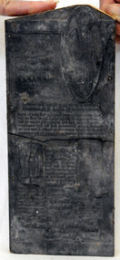
printer's block, 1920's
This printer's block was used by the Snowy River Mail in the 1920's. This block is an advertisement for Tomlinson and McFarlane Bros, Drapers and General Merchants of Nicholson Street, Orbost.Since 1890 the Snowy River Mail has been the local newspaper of the Orbost district.This local paper has been the means by which readers in Orbost were able to learn about newsworthy events and issues in their local community for over a century.A printer's block from the Snowy River Mail. It is an advertisement for ladies' wear in the 1920's. It is an ad for Tomlinson and McFarlane Bros.of Nicholson Street Orbost and advertises fashionable contour corsets. The plate is nailed onto a block of chipboard.printing newspaper media advertisement tomlinson-and-mcfarlane-bros -
 Federation University Historical Collection
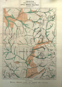
Book, Report on the Little Bendigo or Nerrena Gold-Field, Ballarat, 1901, 1901
Blue soft covered foolscap book of 4 pages. The book includes a folded, colour contour plan shewing reefs and Surface Works Little Bendigo Gold Field and an Underground Survey of Mines, Metropolitan, Monte Cristo Linelittle bendigo, nerrena, h.s. whitelaw, william baragwanath, geology, monte christo, monte cristo, neerena, nerrina, plans, mining cgt -
 Ballarat Tramway Museum
Map, Australian Survey Corps, "Victoria Ballan", 1933
Topographic map of the Ballan area - includes Bacchus Marsh and Bungaree, No. 837, Zone 7, Army Map, dated 1933, 1:63360. Shows rail lines, roads, elevations, contours. Collected with relevance to the Museum's association with the area, at Bungareetrams, tramways, bungaree, map -
 Kiewa Valley Historical Society
Maps 3D - National Parks
Used by the employees of National Parks. The maps show the topography and contours in 3D when used with the stereoscope KVHS 0743. This enables the photographed area to be compared to previous photos and enables the planning of construction of eg. new roads etc. Digital information is now available.These photographs give the topography and contours of vast local areas eg. Mt Feathertop and Tawonga township.when used with a stereoscope. Black and white large aerial photos of the Bogong High Plains area. 14 to 20 of them all on thick paper and the same size as the brown wooden box which holds them. The box hasn't got a lid at the top.Identified and catalogued by National Parksmaps showing topography, national parks, stereoscope -
 Wodonga & District Historical Society Inc
Decorative object - Decorative ceramic bowl
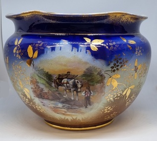
This bowl was used in the home of Mrs. Laura Sommer nee Costa grandmother of one of the life members of Wodonga & District Historical Society who donated this item to our collection. It is representative of decorative household items in the early to mid 20th century.This item is an outstanding example of popular decorative household items from the 19th and early 20th century.A large ceramic decorative bowl featuring rural images. The primary colours of the bowl is a deep blue with gilt edges and markings. It features 2 rural scenes showing men with horses and a cart. The top edge is slightly contoured. There is a maker's mark underneath the bowl.Maker's map on base: A small flower within and larger flower shape with "MADE IN ENGLAND" written around it.decorative bowls, domestic items, ceramics, english ceramics and porcelain -
 Bendigo Historical Society Inc.
Map - GREAT EXTENDED HUSTLERS MINE - LOCALITY MAP OF GREAT EXTENDED HUSTLERS MINE
Location map showing the Hustlers line of mines and some other ones. Map has contours with heights. Mines are named and most of them have the depth printed beside the name. Street names are also included. Map is pasted onto a larger piece of paper.mine, gold, great extended hustlers., great extended hustlers mine, locality map of great extended hustlers mine, great extended hustlers trib shaft, hustlers extended, imperial hustlers shaft, royal hustlers shaft, hustlers royal reserve park shaft, hustlers royal reserve no 2, garden gully e shaft, the golden one shaft -
 Whitehorse Historical Society Inc.
Map, Melbourne Metropolitan Area Base Map, 1957?
Sheet 254 of part of the Municipality of Nunawading and part of the Parish of Nunawading, showing roads, block numbers, creeks and contours mostly south of Canterbury Road.Sheet 254 of part of the Municipality of Nunawading and part of the Parish of Nunawading, showing roads, block numbers, creeks and contours mostly south of Canterbury Road. Prep. from State Aerial and Cadastral survey information, August 1957. Scale: 400 ft = 1 inchSheet 254 of part of the Municipality of Nunawading and part of the Parish of Nunawading, showing roads, block numbers, creeks and contours mostly south of Canterbury Road. city of nunawading, cadastral -
Bendigo Historical Society Inc.
Map - GEOLOGICAL MAP OF BENDIGO GOLD FIELD
Map of Bendigo gold field showing anticlines, synclines, shaft, alluvial deposits and contour lines. Map is in two sections. This map forms part of the Geological Survey of Victoria, Structure of Bendigo Goldfield report, No. 47, 1923. H.Herman, late Director of Geological Survey.Geological Survey Victoriabendigo, gold mining, geological map -
Southern Sherbrooke Historical Society Inc.
Map, Dept of land s & Survey, Dandenong Ranges Area Sheet 28, Jan-56
Owned by David Walker, previously of Menzies Creek. Given by him to Rex Breen in 2001 for donation to society.Aerial survey map of parts of Gembrook, Monbulk and Naree Worran parishes (Victoria). Scale: 10 chains to 1 inch, contour interval 20 feet. Shows Menzies Creek and parts of Kallista, Clematis, Selby and Belgrave South. Ringwood D2C or 849D2C, Zone 7"16563" in pen on top left corner of reverse. -
 Tennis Australia
Racquet, Circa 1988
A Pro Kennex 'Power Champ 3' experimental tennis racquet, featuring a 'wide contour design', and a rare double handle wrapped in Wilson 'Super Tack' handle grip. Materials: Graphite, Paint, Plastic, Adhesive tape, Synthetic material, Ink, Fibreglass, Nylon, Metaltennis -
Bendigo Historical Society Inc.
Map - DEBORAH MINE - MAP OF LINES OF REEF AND MINES (BENDIGO)
Two adjoining photocopies of part of map of Bendigo Goldfield showing lines of reef, mines, streets, locations and contour lines. Map is a beige colour with darker lines and letters. Some of the mines have their depths printed beside them. This item is stored in Map drawer 7mine, gold, deborah mine, deborah mine, map of lines of reef and mines (bendigo). -
 Forests Commission Retired Personnel Association (FCRPA)
Buckingham steel climbing spurs (missing leather straps)
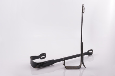
Spurs were attached with leather straps which held them to the climbers legs. The straps are missing on this pair They have a contoured shank with offset stirrup for the climbers boots Buckingham manufacturing dates back in America to 1896. Climbing spurs were made in their blacksmith shop and were popular with linesmen, loggers and tree arborists. Buckingham steel climbing spurs -
 Woodend RSL
British WWII RAF and Special Forces Survival Knife, Late WWII?
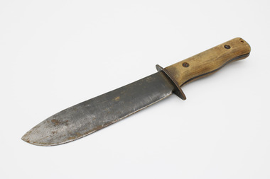
A rare example of a Type D Survival Knife issued to British RAF during the latter part of WWII.Heavy duty survival knife with single edged oval shaped broad blade and wooden handle contoured for grip. Two large screws secure the grips. The pommel end has a wrist cord hole (cord not present). See also item 2020.000034-2 (leather sheath). Blunt end of blade near grip there is engraved '27C/2360', reverse side is the makers mark 'Rodgers Sheffield England'.british airforce, survival knife, ww2, wwii, type d -
Whitehorse Historical Society Inc.
Map, Melbourne Metropolitan Area Base Map series. Sheet 214, c1960
Map showing northern section of the City of Nunawading together with parts of Shire of Doncaster and Templestowe.Map showing northern section of the City of Nunawading together with parts of Shire of Doncaster and Templestowe. Shows roads, creeks, block numbers and contours at 5 feet vertical increments. Note on map: 'prepared ... from State Aerial Survey, January 1957 and Cadastral Survey information February 1959'.Map showing northern section of the City of Nunawading together with parts of Shire of Doncaster and Templestowe. maps, city of nunawading, shire of doncaster and templestowe -
 Bendigo Historical Society Inc.
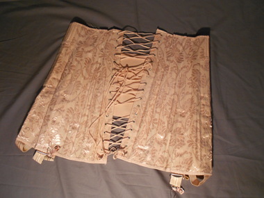
Clothing - WOMEN'S CLOTHING: PINK BONED CORSET
Women's clothing: pink boned corset. Garment is patterned with flower motif. Suspenders attached to bottom of corset. Corset is laced up the back through eyelets. Item donated by Mrs. J. Mannix, 54 Bannister Street, Bendigo. On inside of garment 'Beauty's Contour, 148, Type ABD U.B.'female, corset, women's clothing, corset -
 Bendigo Historical Society Inc.
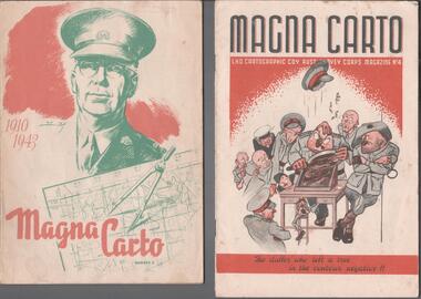
Magazine - THE BROOK AND ANDERSON FORTUNA COLLECTION: MAGNA CARTO MAGAZINE
Two copies of the Magna Carto Magazine of the Australian Survey corps. Issue two and four. Issue two has a drawing of a soldier and a map and compass with the words 1910-1943 on the cover. Issue four has a group of soldiers around a table with the words ''the duffer who left a tree in the contour negative!!''.military, world war 2 -
 Melbourne Tram Museum
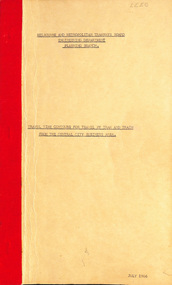
Document - Report, Melbourne & Metropolitan Tramways Board (MMTB), "Travel time contours for travel by tram and train from the central business area", Jul. 1966
Report - Foolscap 11 typed pages, 12 bound sheets of diagrams and tables with card covers, with red binding strips, titled ""Travel time contours for travel by tram and train from the central business area", dated July 1966. Looks at journey time for both trams and trains with two speeds - 10mph and 18mph.In top left hand corner "Lees" in penciltrams, tramways, mmtb, tramways, railways, speed of services, travel promotion -
 Greensborough Historical Society
Map, Melbourne and Metropolitan Board of Works. Survey Division, MMBW, Yarra 2500 / 12.24. Plenty and Blue Lake, 1977_10
Melbourne and Metropolitan Board of Works. Yarra 2500 [base map]. 12-24, Municipalities of Whittlesea 239 and Diamond Valley 257. Shows street names, easement sizes, lot numbers, lodged plan numbers, names of prominent features, contour values, creek or river names. Watsonia Railway Station and environs. Prominent streets: Memorial Drive. Includes Plenty River and Blue Lake in the Plenty Gorge.MMBW Map in 1:2500 [scale] series. Cream parchment with green tape reinforcing on edges and punched holes on left edge.mmbw, melbourne and metropolitan board of works, shire of diamond valley, plenty - maps, blue lake -
 Greensborough Historical Society
Map, Melbourne and Metropolitan Board of Works. Survey Division, MMBW, Yarra 2500 / 13.21. Central Greensborough, 1979_05
Melbourne and Metropolitan Board of Works. Yarra 2500 [base map]. 13-21, Parishes of Keelbundora 2856 and Nillumbik 3310, Municipality of Diamond Valley 257. Shows street names, easement sizes, lot numbers, lodged plan numbers, names of prominent features, contour values, creek or river names. Central Greensborough. Prominent streets: Main Street, Para Road, St Helena Road and Diamond Creek Road.MMBW Map in 1:2500 [scale] series. Cream parchment with green tape reinforcing on edges and punched holes on left edge.mmbw, melbourne and metropolitan board of works, shire of diamond valley, greensborough - maps -
 Greensborough Historical Society
Map, Melbourne and Metropolitan Board of Works. Survey Division, MMBW, Yarra 2500 / 12.19. Watsonia, Simpson Army Barracks, 1983_03
Melbourne and Metropolitan Board of Works. Yarra 2500 [base map]. 12-19, Parish of Keelbundora 2856, Municipalities of Diamond Valley 257 and 228. Shows street names, easement sizes, lot numbers, lodged plan numbers, names of prominent features, contour values, creek or river names. Watsonia Barracks (Simpson Army Barracks) and environs. Prominent streets: Yallambie Road, Greensborough Road, and Strathallan Road. MMBW Map in 1:2500 [scale] series. Cream parchment with green tape reinforcing on edges and punched holes on left edge.mmbw, melbourne and metropolitan board of works, shire of diamond valley, watsonia - maps -
 University of Melbourne, Burnley Campus Archives
Plan, Burnley Gardens. City of Richmond. Parish of Jika Jika - County of Bourke, 1927
Part-coloured plan showing drainage, sewerage drains, taps and waterstops. Area bounded by Swan St. To N, Yarra River on E and Richmond Park on SW side. Contour lines of orchard depicted, laying pens and yards. Coloured area depicts pavilion with surrounding garden and paths layout pencilled in. Photo-Lithograph by Dept. of Lands & Survey, Melbourne by W. Butsonsewerage, drainage, lithograph, pavilion -
 Greensborough Historical Society
Map, Melbourne and Metropolitan Board of Works. Survey Division, MMBW, Yarra 2500 / 12.20. Watsonia Railway Station and environs, 1983_03
Melbourne and Metropolitan Board of Works. Yarra 2500 [base map]. 12-20, Parishes of Keelbundora 2856, Municipalities of Diamond Valley 257 and 228. Shows street names, easement sizes, lot numbers, lodged plan numbers, names of prominent features, contour values, creek or river names. Watsonia Railway Station and environs. Prominent streets: Watsonia Road, Elder Street, Morwell Avenue and Nepean Street. Includes former Watsonia Technical School and Gresswell Rehabilitation Centre sites.MMBW Map in 1:2500 [scale] series. Cream parchment with green tape reinforcing on edges and punched holes on left edge.mmbw, melbourne and metropolitan board of works, shire of diamond valley, watsonia - maps -
 Greensborough Historical Society
Map, Melbourne and Metropolitan Board of Works. Survey Division, MMBW, Yarra 2500 / 12.21. Watsonia North, 1979_02
Melbourne and Metropolitan Board of Works. Yarra 2500 [base map]. 12-22, Parish of Keelbundora 2856, Municipality of Diamond Valley 257. Shows street names, easement sizes, lot numbers, lodged plan numbers, names of prominent features, contour values, creek or river names. Watsonia Railway Station and environs. Prominent streets: Grimshaw Street, William Street and Macorna Street. Includes former Institute of Social Welfare (now Loyola College) Lines Reserve and Binnak Park.MMBW Map in 1:2500 [scale] series. Cream parchment with green tape reinforcing on edges and punched holes on left edge.mmbw, melbourne and metropolitan board of works, shire of diamond valley, watsonia - maps, bundoora - maps -
 Kew Historical Society Inc
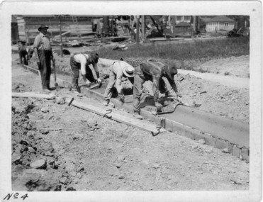
Photograph - Instructional photograph No.4: Using concrete for street kerbs, Portland Cement Association, 1921
One of seven photographs produced by the Portland Cement Association in 1921 showing how concrete kerbs could be created. Portland Cement Association (PCA) was founded in 1916. From 1917, the association actively promoted the benefits of concrete for road works in Australian newspapers. In the nineteenth century in Melbourne (Vic.) 'made roads' typically had gutters and kerbing lined with bluestone.The photographs are important evidence of the availability of instructional models for the use of concrete in street works in Victoria. While the photographs date from the early 1920s, the use of concrete for kerbing did not reach its maturity until after World War 2. The photos demonstrate knowledge about and the use of concrete in street works in a major Melbourne municipality at an early period.Black and white photograph with printed instructions on the reverse showing the production of concrete kerbing on 67th Street, West Allis, Milwaukee, Wisconsin (USA). The photograph was produced by the Portland Cement Association of Chicago in 1921 and used within the Chief Engineer's Department of the City of Kew (Vic.)."4th - showing the three principal filling operations - 1st Trimming base course; 2nd Mortar facing applied and Trimmed 1/8th high with wooden template; 3rd - Mortar face finished to exact contour with metal finishing trowel, having a rounded face in contact with mortar facing." street works, kerbing, gutters, concrete, portland cement association -
 Kiewa Valley Historical Society
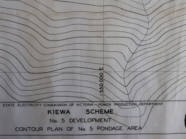
Plans - Kiewa Works Area and Environs
State Electricity Commission of Victoria constructed the Kiewa Hydro Electric Scheme from the late 1940s to 1961. These plans were used during the construction.Plans and Maps were used during the construction of the Kiewa Hydro Electric SchemeTransparent with blue tinge plans/maps created by the SECV during the construction of the Kiewa Hydro Electric Scheme. 1. Kiewa Scheme No 5 Development Contour Plan of No 5 Pondage Area 2. Mt Beauty Township 3. Kiewa Scheme No 1 Development - McKay Creek Area, Construction Layout 4. Kiewa Works and Environs 5. North Eastern Victoria and Adjoining Snowy Mountains Regionsecv, kiewa hydro electric scheme plans