Showing 105 items
matching great eastern
-
 Glenelg Shire Council Cultural Collection
Photograph - Photograph - Cape Grant Quarry, Portland, 03/08/1953
Port of Portland Authority Archives. From the Port of Portland website: Just 6km south of Portland, the Cape Grant Quarry is located on the eastern cliff of Cape Sir William Grant. This cape represents the core of a volcanic complex between two collapse calderas which underlie Nelson and Grant Bays to the west and east respectively. The Cape Grant quarry supplied an inexhaustible quantity of bluestone for the building of the new Portland harbour. The first stone was tipped at the root of the main breakwater on 17 November 1952. A small band of interested citizens were there to see the historic event. In the building, the breakwater was consolidated by the heavy traffic of Euclid’s and bulldozers and was further solidified by several storms that swept over it. Nowadays, blasting at the quarry is heavily regulated and carried out under the instructions of a qualified “powder monkey.” The days of seeing large explosions, along with the deep long loud BOOM are long gone with techniques of controlled blasting now improving overall environmental and safety standards.Front: Back- Purple PHT Stampport of portland archives, cape grant quarry, harbour development, construction -
 Flagstaff Hill Maritime Museum and Village
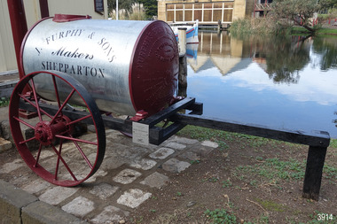
Vehicle - Furphy Water Cart, J. Furphy & Sons, c. 1942
This horse-drawn, two-wheeled cart with a tank, is known as a Furphy Farm Water Cart that was made in Shepparton, northern Victoria, c. 1942. John Furphy (1842-1920) was born in Moonee Ponds, in 1842 to Irish immigrant parents and subsequently raised in the Yarra Valley before the family moved to Kyneton in central Victoria, where he completed an apprenticeship with the firm Hutcheson and Walker. Murphy began operations of his own at a site on Piper Street in Kyneton in 1864. He relocated for a business opportunity and founded the first blacksmiths and wheelwrights shop in the newly surveyed town of Shepparton in 1873. Furphy invented many farming tools and machines including a patented grain-stripper, and won awards at the 1888-89 Melbourne International Exhibition. His most famous invention is the Furphy Farm Water Cart, designed in the 1880s, at a time when water for most households and farms was carted on wagons in wooden barrels. The Furphy’s water cart is a single item that combines a water metal tank and a cart. The design of the cart was simple yet effective, and became popular very quickly and established itself as a vital piece of farming equipment. The water cart has had a number of words cast into its ends over many years. References to the foundry’s location in Shepparton, as well as advertising of other products also manufactured by J. Furphy & Sons were present on the ends. However, the most significant set of words to feature on the tank, was a poem encouraging continual improvement: ‘Good Better Best, Never Let it Rest, Until your Good is Better, And your Better Best’. During The Great War (1914-1918), the water cart was used by the Australian militarily at a large AIF (Australian Imperial Force) camp in Broadmeadows (Melbourne) where thousands of men were camped for months, before being transported aboard. Furphy Water Carts provided water to the troops, and were usually placed near the camp latrines, which was one of the few places the troops could share gossip and tall tales away from the prying eyes and ears of their officers. The water cart drivers were also notorious sources of information, despite most of their news being hearsay, or totally unreliable. By the time the men of the AIF were in engaged in combat on the Gallipoli Peninsula and the Western Front, the carts used for water supply had no markings and became simply referred to as Furphys. This owed as much to the coining of the term ‘Furphy’, Australian slang for suspect information or rumour. After a number of decades as principally a soldier’s word, 'Furphy' entered the broader Australian vernacular and was used mainly by the political class until recently when the term was taken up by a Australian brewer as a beer brand. This Furphy Water Cart was purchased by Friends of Flagstaff Hill in 2014. The support of local individuals, organisations and businesses enabled its restoration and later its installation alongside the existing late-19th century water pipe stand and 1940s hand pump The Furphy Farm Water Cart is of historical significance as it represents a famous Australian time-saving and energy-saving invention of the 1880s, replacing the labour intensive activity of collecting and dispensing water from barrels and casks on the back of carts. The water cart’s connection with manufacturing companies J. Furphy & Sons and Furphy Foundry are significant for being early Australian businesses that are still in operation today. Furphy carts are of military significance for the role they played during The Great War (1914-1918) in Australian army camps, and theatres of war in Europe and the Middle East, to supply the AIF troops with fresh water. A wooden framed, two-wheeled, horse-drawn cart, fitted with a horizontally mounted, cylindrical metal tank. The tank is made of rolled, sheet steel with a riveted seam, and cast iron ends with cast iron ends. The spoked metal wheels have fitted flat iron tyres and metal hubs. A metal pipe is joined to the outlet. The tank is silver coloured, the ends, wheels and trims are crimson, and the script lettering on tank sides is black. There are inscriptions on the tank, ends, and hubs. The water tank was made in 1942 in Shepparton, Australia, by J. Furphy & Sons and has a capacity of 180 gallons (848 litres). Hub perimeter, embossed “J. FURPHY & SONS” “KEEP THE / BOLTS TIGHT” Hub centre embossed [indecipherable] Tank, each side, painted “J. FURPHY & SONS / Makers / SHEPPARTON” Tank ends, embossed – “FURPHY’S FARM WATER CART” “BORN ABOUT 1880 – STILL ‘GOING STRONG’ 1942” “j. FURPHY & SONS / MAKERS / SHEPPARTON - VIC “ “S - - - - - L MANUFACTURERS” [SPECIAL] “SPIKE ROLLERS” “SINGLE TREES” “PLOUGH WHEELS” “IRON CASTINGS” “LAND GRADERS” “STEEL DELVERS” “CAST IRON PIG” “CHAIN YOKES” “GOOD – BETTER – BEST / NEVER LET IT REST / TILL YOUR GOOD IS BETTER / AND YOUR BETTER – BEST” Image [Stork carrying a baby] above shorthand, transcribed "Produce and populate or perish" Image [Furphy Pig Feeder] beside ‘Cast Iron Pig’ Shorthand, transcribed “"Water is the gift of God but beer and whiskey are concoctions of the Devil, come and have a drink of water"warrnambool, flagstaff hill maritime museum, water cart, furphy cart, furphy tank, furphy farm water cart, furphy, john furphy, john furphy & sons, furphy foundry, kyneton, shepparton, mobile water tank, jinker, hutchinson & walker, blacksmith, farm equipment, implement maker, tool maker, horse drawn, stork and baby, good, better, best, barrel, tank, first world war, wwi, eastern front, gallipoli, j furphy & sons -
 Monbulk RSL Sub Branch
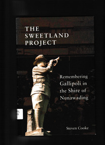
Steven Cooke, The Sweetland Project : remembering Gallipoli in the Shire of Nunawading, 2015
A chance discovery made on a tour of Anzac Cove provided an immediate link between Gallipoli and Melbourne’s Eastern Suburbs. In the lead up to the Centenary of Anzac, ‘The Sweetland Project’ (named after a Box Hill man, Stephen Sweetland) became a broader search for the connections between Gallipoli and the former Shire of Nunawading, revealing 27 men from the former shire who died during the Gallipoli campaign. This book traces their stories and the reaction to the Great War of the local community, and shows how personal and collective memories of their experiences still resonate today.Index, bibliography, notes, ill, p.211.non-fictionA chance discovery made on a tour of Anzac Cove provided an immediate link between Gallipoli and Melbourne’s Eastern Suburbs. In the lead up to the Centenary of Anzac, ‘The Sweetland Project’ (named after a Box Hill man, Stephen Sweetland) became a broader search for the connections between Gallipoli and the former Shire of Nunawading, revealing 27 men from the former shire who died during the Gallipoli campaign. This book traces their stories and the reaction to the Great War of the local community, and shows how personal and collective memories of their experiences still resonate today.world war 1914-1918 - campaigns - gallipoli, gallipoli campaign - personal recollections -
 Monbulk RSL Sub Branch
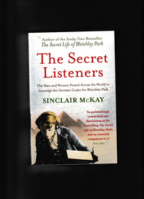
Book, Aurum Press Ltd, The secret listeners : The men and women posted across the world to intercept the secret german codes for Bletchley Park, 2012
Before Bletchley Park could break the German war machine's code, its daily military communications had to be monitored and recorded by 'the Listening Service', the wartime department whose bases moved with every theatre of war (Cairo, Malta, Gibraltar, Iraq, Cyprus) as well as having listening stations along the eastern coast of Britain to intercept radio traffic in the European theatre. This is the story of the - usually very young - men and women sent out to farflung outposts to listen in for Bletchley Park, an oral history of exotic locations and ordinary lives turned upside down by a sudden remote posting - the heady nightlife in Cairo, filing cabinets full of snakes in North Africa, and flights out to Delhi by luxurious flying boat.Index, ill, map, p.354.non-fictionBefore Bletchley Park could break the German war machine's code, its daily military communications had to be monitored and recorded by 'the Listening Service', the wartime department whose bases moved with every theatre of war (Cairo, Malta, Gibraltar, Iraq, Cyprus) as well as having listening stations along the eastern coast of Britain to intercept radio traffic in the European theatre. This is the story of the - usually very young - men and women sent out to farflung outposts to listen in for Bletchley Park, an oral history of exotic locations and ordinary lives turned upside down by a sudden remote posting - the heady nightlife in Cairo, filing cabinets full of snakes in North Africa, and flights out to Delhi by luxurious flying boat.world war 1939-1945 - great britain - intelligence, world war 1939-1945 - cryptography -
 Bendigo Historical Society Inc.
Document - MAJOR MITCHELL AND MOUNT ALEXANDER
Typed notes mentioning the naming of Mount Alexander, Coliban, Campaspe and who named them. Also the origins of the names.document, major mitchell and mount alexander, tommy-came-last, the major mitchell tourist trail, major general john byng, phillip of macedonia, alexander the great, henty s, surveyor davidson, alexander mollison, george augustus robinson, william morton, mr charles hotson ebden, john randell, public library of melbourne, les blake, governor burke, phillip parker king, crown solicitor henry field gurner, arthur phillip, hume, australia felix expedition, l blake, place names of victoria, g brenmer, booklet for secondary schools, m cannon, historical records of victoria vol 1, j h l cumpston, thomas mitchell surveyor general and explorer, h f gurner, chronicle of port phillip, t l mitchell, three expeditions into the interior of eastern australia, a f mollison, an overlanding diary, w l morton, adventures of a pioneer, m s 5188, itinerary from the journal of the exploring expedition returning from portland bay, m s 5189, mitchell's 1837 map, j o randell, pastoral settlement in northern victoria vol 1, pastoral settlement in northern victoria vol 2, records of the victorian archaeological survey number 5, journals of george augustus robinson, t c sargent, some peninsular names in australia felix, w h wells, a geographical dictionary or gazetteer of the australian colonies -
 Anglesea and District Historical Society
Broadcast Listener's Licences, 1961, 1962, 1963
6 pieces - 3 x Anglesea and 3 x Geelong. 6 Broadcasters Licences issued to Mr J Murch of Anglesea (3) and to Mrs J. Murch of Eastern Beach, Geelong. Licence No. 11 16883 on all 6. Fee paid 2 pounds 15 as stamped by the Anglesea Post Office. Penalty for operating unlicensed equipment. Fine not exceeding 100 pounds. A BROADCAST LISTENER'S LICENCE (hereby granted to) MR. J. MURCH, ANGLESEA. 12 JUNE, 1961, 1963, 1964. MRS. J. MURCH, 14 EASTERN BEACH, GEELONG. Signed by G Edwards & B Edwards.broadcast listener's licence, postmaster general, j. murch -
 Anglesea and District Historical Society
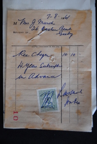
Receipt, Eclipse Check Book Co. Pty. Ltd, 7/8/1961
Receipt from Anglesea Bowling Club to Mrs. J. Murch for a 4 year subscription paid in advance. It is stamped and signed: Victorian Stamp Duty by L. McMahon. Letter attached from Anglesea Bowling Club explains that the Bowling Club will be open for play on 10th December 1961 and play will begin at 1.45 pm.Receipt - Mrs. J. Murch, 26 Eastern Beach, Geelong. / Rec. cheque 10/10. / 4 years subscription in advance / Dated 7/8/61. / No. 10. / Signed : L. McMahon. Stamp with "Victoria Stamp Duty".anglesea bowling club, j. murch, 1961, l. mcmahon -
 Anglesea and District Historical Society
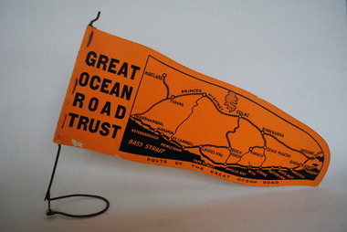
Pennant, Unknown
Orange pennant flag listing towns on and near the Great Ocean Road. List of town names on pennant - (west to east) Mortlake, Warrnambool, Nirranda, Terang, Port Campbell, Lavers Hill, Colac, Beech Forest, Apollo Bay, Wye, Birregurra, Forrest, Deans Marsh, Peterborough, Princetown, Lorne, Eastern View, Airy's Inlet, Anglesea, Torquay, Geelong, Barwon Heads.GREAT/ OCEAN/ ROAD/ TRUST. Map of Area/ Route of the Great Ocean. (Orange - on wire stand. Printed on both sides.) great ocean road trust -
 Anglesea and District Historical Society
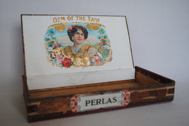
Cigar Box, Perlas?, Estimated date: mid 20th century
Wooden cigar box probably from the mid 20th century. The inside of the top of the box has a picture of an Eastern woman with coins and flowers. Perlas - is a small cigar taking 30 minutes to smoke. This cigar contains Manila filler.Top: GEM OF THE EAST / MANILA / FILLER Side: PERLAS (on label). 25 (burned on wood). Label along edges of top, sides and bottom - "PUROS FABRICA DE TOBACCO - FLORFINA"smoking, cigars, perlas, gem of the east -
 Anglesea and District Historical Society
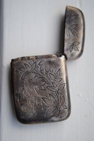
Vesta Case, Estimated: 1889-1890
Silver vesta case with trumpeted flower etched on one side and rose like flower on the other. Match striker on the bottom. Stylized CJS on refers to Charles James Stevens born Gibraltar 1/1/1892, died 2/3/1973, buried Geelong Eastern Cemetery. He married Edna Olive in 1966. Edna and her sister, Elsie Samuel, lived in Pickworth Avenue, Anglesea and were active in the Historical Society.Etched with trumpeted and rose-like flowers and the letters "CJS". Hallmarks: cc, P, anchor, Lion (P=1889-1890). Arrow (anchor) - Birmingham.matches, silver, charles james stevens -
 Anglesea and District Historical Society
Scribe Box, Estimated 1800's
Mid-Eastern brass travelling scribe box. 19th century. Having a pen or quill case with a crown finnial on lid. Inkwell with shell lid. Engraved decoration throughout. Touchmark on pen case.Decorative engravingscribe, pen case, calligraphy -
 Victorian Aboriginal Corporation for Languages
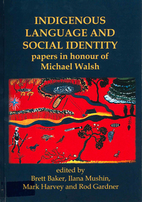
Book, Brett Baker, Indigenous language and social identity : papers in honour of Michael Walsh, 2010
For almost 40 years, Michael Walsh has been working alongside Indigenous people: documenting language, music and other traditional knowledge, acting on behalf of claimants to land in the Northern Territory, and making crucial contributions to the revitalisation of Aboriginal languages in NSW. This volume, with contributions from his colleagues and students, celebrates his abiding interest in and commitment to Indigenous society with papers in two broad themes. ?Language, identity and country? addresses the often complex relations between Aboriginal social groups and countries, and linguistic identity. In ?Language, identity and social action? authors discuss the role that language plays in maintaining social identities in the realms of conversation, story-telling, music, language games, and in education. ?Language and Social Identity in Australian Indigenous Communities? will be of interest to students of linguistics, Indigenous studies, anthropology, and sociology. Contents: 1. Introduction /? Rod Gardner ... [et al.] 2. Michael Walsh : a personal reflection /? Ros Fraser 3. Place and property at Yintjingga/?Port Stewart under Aboriginal Law and Queensland Law /? Bruce Rigsby and Diane Hafner 4. Linguistic identities in the eastern Western Desert : the Tindale evidence /? Peter Sutton Juwaliny : dialectal variation and ethnolinguistic identity in the Great Sandy Desert /? Sally Dixon 6. Who were the 'Yukul'? and who are they now? /? Brett Baker 7. Colonisation and Aboriginal concepts of land tenure in the Darwin region /? Mark Harvey 8. Aboriginal languages and social groups in the Canberra region : interpreting the historical documentation /? Harold Koch 9. The Kuringgai puzzle : languages and dialects on the NSW Mid Coast /? Jim Wafer and Amanda Lissarrague 10. Dawes' Law generalised : cluster simplification in the coastal dialect of the Sydney language /? David Nash 11. Space, time and environment in Kala Lagaw Ya /? Lesley Stirling 12. Turn management in Garrwa mixed-language conversations /? Ilana Mushin and Rod Gardner 13. Laughter is the best medicine : roles for prosody in a Murriny Patha conversational narrative /? Joe Blythe 14. Collaborative narration and cross-speaker repetition in Umpila and Kuuku Ya'u /? Clair Hill 15. Co-narration of a Koko-Bera story : giants in Cape York Peninsula /? Paul BlackMaps, b&w photographs, charts, word listslanguage and identity, language maintenance, language and culture, language and country -
 Victorian Aboriginal Corporation for Languages
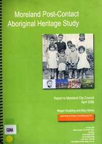
Book, Megan Goulding et al, Moreland post-contact Aboriginal heritage study, 2006
This study aims to identify Aboriginal heritage sites and landscape associations in the Moreland municipality that date from the pre-contact period through to the early contact period when Europeans settled in and around the area, to the present day.maps, colour photographs, b&w photographs, tableswoiworung, woi wurrung, wurundjeri, waa, bunjil, werribee river, port phillip, mount baw baw, great dividing range, yarra river, eastern kulin, gunung willam balluk, william barak, john batman, william thomas, moreland history, moieties, local history, colonisation -
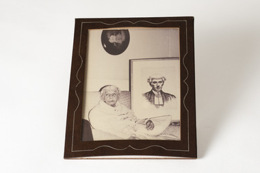
 Chiltern Athenaeum Trust
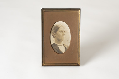
Photograph - Framed Photograph from W.C.Busse Collection
This is a photograph from the W.C. Busse Collection and a woman is illustrated with a bun hair tie and a pearl necklace. Wilfred Clarence Busse 1898-1960, born in Chiltern, was a barrister and author. His family moved to the region during the gold rush and continued to reside in the area, purchasing land adjacent the Murray River. Busse attended school at Wesley College and studied law at the University of Melbourne. Busse went on to become a barrister, often in the chambers of Sir Leo Finn Bernard Cussen (1859-1933) a judge of the Supreme Court of Victoria. Time spent on a Victorian station in his early twenties, as well as careful documentary research, informed the writing of his historical novels of bush life. "The Blue Beyond; A Romance of the Early Days in South Eastern Australia" was written in 1928 and published in 1930. "The Golden Plague: A Romance of the Early Fifties", written in 1930, won the T. E. Role gold medal for the best historical novel published that year and went on to become a best seller. His passion for the region led him to write “The History of Chiltern”, which was published in a serial form in the Chiltern Federal Standard from 1922-1923. He was a member of the Chiltern Athenaeum upon his death in 1960. The photograph belongs to the W.C. Busse Collection, which is of great importance to Chiltern Athenaeum. Wilfred Clarence Busse was a barrister and author born in Chiltern and drew inspiration to write novels from his life growing up in Chiltern.Black and white framed photograph printed on paper and wooden frame.w.c. busse collection, wilfred clarence busse, chiltern, barrister, author, murray river, wesley college, university of melbourne, chambers, leo finn bernard cussen, judge, supreme court of victoria, historical novels, bush life, the blue beyond, the golden plague, t. e. role gold medal, the history of chiltern, chiltern federal standard, chiltern athenaeum -
 Chiltern Athenaeum Trust
Photograph - Framed Photograph from W.C.Busse Collection
This is a photograph from the W.C. Busse Collection and an elderly woman is illustrated sitting on a couch. Wilfred Clarence Busse 1898-1960, born in Chiltern, was a barrister and author. His family moved to the region during the gold rush and continued to reside in the area, purchasing land adjacent the Murray River. Busse attended school at Wesley College and studied law at the University of Melbourne. Busse went on to become a barrister, often in the chambers of Sir Leo Finn Bernard Cussen (1859-1933) a judge of the Supreme Court of Victoria. Time spent on a Victorian station in his early twenties, as well as careful documentary research, informed the writing of his historical novels of bush life. "The Blue Beyond; A Romance of the Early Days in South Eastern Australia" was written in 1928 and published in 1930. "The Golden Plague: A Romance of the Early Fifties", written in 1930, won the T. E. Role gold medal for the best historical novel published that year and went on to become a best seller. His passion for the region led him to write “The History of Chiltern”, which was published in a serial form in the Chiltern Federal Standard from 1922-1923. He was a member of the Chiltern Athenaeum upon his death in 1960.The photograph belongs to the W.C. Busse Collection, which is of great importance to Chiltern Athenaeum. Wilfred Clarence Busse was a barrister and author born in Chiltern and drew inspiration to write novels from his life growing up in Chiltern.Black and white framed photograph printed on paper.Obverse: 1,018/w.c. busse collection, wesley college, leo finn bernard cussen, supreme court of victoria, wilfred clarence busse, chiltern, murray river, barrister, author, bush life, the blue beyond, the golden plague, t. e. role gold medal, the history of chiltern, chiltern federal standard, chiltern athenaeum, historical novels, university of melbourne, gold rush, best seller -
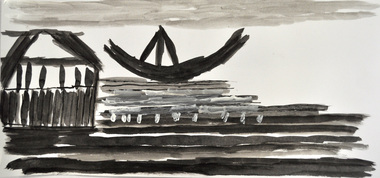 Nillumbik Shire Council
Drawing: Tim RYAN, Tim Ryan, Queenscliff 1,2 and 3, 2012
“Queenscliff (three black and white boat/ship themed set), is a depiction of a trio of sailing vessels, and a typical example of Tim Ryan’s process and style / It illustrates three images from separate editions of National Geographic – a much-loved and constantly revisited source of inspiration / Tim has reduced his subject matter to minimal line, managing to capture the form and character of the scene and the people within with delicacy and sensitivity / As is also a common trait, Tim has discarded the idea of a using a title describing the actual scenes in favour of one that holds much greater personal significance / Queenscliff is the site of his family holiday home, hence a place evoking decades of memories connected with water, horizon and water-based activity and interaction.Tim Ryan has worked within the Studio Art Program at Araluen for almost a decade / Araluen is based in the north eastern suburbs of Melbourne (Nillumbik region), that provides accommodation and day services for adults with an intellectual disability / Creating and sharing artwork is one way Araluen participants express their thoughts, personalities and abilities. The art program allows them to develop a sense of achievement and access society as equal and valued participants / Tim puts a great deal of effort into selecting his subject and arranging his page / He immerses himself in the image, studying it thoroughly and sometimes tracing over it with his finger before commencing / He focuses on the different elements and relationships that inspire, bringing out the lines, colours and shapes most fitted for translation into the picture / Favourite references are photo-laden books and magazines covering topics as broad as nature, history, archaeology, exotic foreign lands and all forms of transport.Three black and white drawings of boats/ships in Queenscliff made using watercolor, ink, fine liner, pencil and acrylic on paper. All drawings are black and white in colour with one drawing rendering a boat in warm red/orange and yellow colours. None shown, catalogue label on backdrawings / black & white / ink / boats / ships / queenscliff / araluen / ryan / disability -
Stawell Historical Society Inc
Photograph, Small portrait of man in suit
Collected by Dorothy Brumby in relation to Great Western ResearchSmall portrait of manAmerican Photo Co 118 Bourke St Melbourne Opposite Eastern Market -
 Torquay and District Historical Society
Black & White Photograph, Legacy of the storm Scammell House
Photograph of deck house room downstairs (Eastern Side )scammel deckhouse -
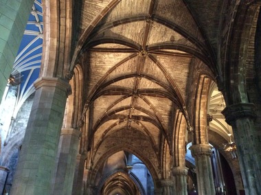
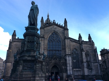 Ballarat Heritage Services
Digital Photograph, St Giles Cathedral, Edinburgh, Scotland, 10/2016
St Giles, also known as the High Kirk of Edinburgh is the principal place of worship for the Church of Scotland. It is very interesting for the mason's marks found on its many stone columns inside the church, and for its connections to the graveyard outside. According to wikipedia, "There is record evidence of a church here, very likely on the present site, in the year 854. In 1120 King Alexander I, rebuilt the church in the Norman style. Of this building characteristic features survived until 1798. During the fourteenth century, Edinburgh was captured and plundered by the English under Edward II. and Edward III., and twice St Giles was laid waste. After restoration, the church was more thoroughly ruined at the Burnt Candlemas in 1387, when Richard II. sacked the city. The western part of the fabric was soon in use again ; but the restoration of the choir and transepts, which were much enlarged, lasted on into the sixteenth century. In 1467 the city endowed St Giles as a collegiate church. It now became usual to speak of the nave, where the stonework was ancient, as the Old Kirk, while the eastern part of the building was called the New Kirk. When the movement for reform drew large crowds to St Giles, separate services began to be regularly held in the Old and New Kirks. Soon this was not enough, and the great church was partitioned off into smaller sections. In 1571 St Giles was seized by Kirkcaldie of Grange, and held by him as a stronghold for Queen Mary. This resulted in serious damage to the structure.Colour photograph of St Giles Cathedral, Edinburgh, Scotlandst giles cathedral, edinburgh, scotland, architecture -
 Ballarat Heritage Services
Digital Photograph, Dorothy Wickham, Interior, St Giles Cathedral, Edinburgh, Scotland, 10/2016
St Giles, also known as the High Kirk of Edinburgh is the principal place of worship for the Church of Scotland. It is very interesting for the mason's marks found on its many stone columns inside the church, and for its connections to the graveyard outside. According to wikipedia, "There is record evidence of a church here, very likely on the present site, in the year 854. In 1120 King Alexander I, rebuilt the church in the Norman style. Of this building characteristic features survived until 1798. During the fourteenth century, Edinburgh was captured and plundered by the English under Edward II. and Edward III., and twice St Giles was laid waste. After restoration, the church was more thoroughly ruined at the Burnt Candlemas in 1387, when Richard II. sacked the city. The western part of the fabric was soon in use again ; but the restoration of the choir and transepts, which were much enlarged, lasted on into the sixteenth century. In 1467 the city endowed St Giles as a collegiate church. It now became usual to speak of the nave, where the stonework was ancient, as the Old Kirk, while the eastern part of the building was called the New Kirk. When the movement for reform drew large crowds to St Giles, separate services began to be regularly held in the Old and New Kirks. Soon this was not enough, and the great church was partitioned off into smaller sections. In 1571 St Giles was seized by Kirkcaldie of Grange, and held by him as a stronghold for Queen Mary. This resulted in serious damage to the structure.Two colour photographs of the interior if St Giles Cathedral, Edinburgh, Scotlandst giles cathedral, architecture, mason's marks, stonemasons, church of scotland -
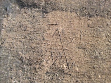 Ballarat Heritage Services
Digital Photograph, Stonemason's marks, St Giles Cathedral, Edinburgh, Scotland, 10/2016
St Giles, also known as the High Kirk of Edinburgh is the principal place of worship for the Church of Scotland. It is very interesting for the mason's marks found on its many stone columns inside the church, and for its connections to the graveyard outside. According to wikipedia, "There is record evidence of a church here, very likely on the present site, in the year 854. In 1120 King Alexander I, rebuilt the church in the Norman style. Of this building characteristic features survived until 1798. During the fourteenth century, Edinburgh was captured and plundered by the English under Edward II. and Edward III., and twice St Giles was laid waste. After restoration, the church was more thoroughly ruined at the Burnt Candlemas in 1387, when Richard II. sacked the city. The western part of the fabric was soon in use again ; but the restoration of the choir and transepts, which were much enlarged, lasted on into the sixteenth century. In 1467 the city endowed St Giles as a collegiate church. It now became usual to speak of the nave, where the stonework was ancient, as the Old Kirk, while the eastern part of the building was called the New Kirk. When the movement for reform drew large crowds to St Giles, separate services began to be regularly held in the Old and New Kirks. Soon this was not enough, and the great church was partitioned off into smaller sections. In 1571 St Giles was seized by Kirkcaldie of Grange, and held by him as a stronghold for Queen Mary. This resulted in serious damage to the structure.Colour photographs of tonemason's marks, St Giles Cathedral, Edinburgh, Scotlandmason's marks, st giles cathedral -
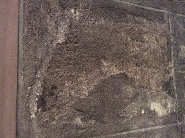 Ballarat Heritage Services
Photograph - Digital Photograph, Stonemason's marks, St Giles Cathedral, Edinburgh, Scotland, 10/2016
St Giles, also known as the High Kirk of Edinburgh is the principal place of worship for the Church of Scotland. It is very interesting for the mason's marks found on its many stone columns inside the church, and for its connections to the graveyard outside. According to wikipedia, "There is record evidence of a church here, very likely on the present site, in the year 854. In 1120 King Alexander I, rebuilt the church in the Norman style. Of this building characteristic features survived until 1798. During the fourteenth century, Edinburgh was captured and plundered by the English under Edward II. and Edward III., and twice St Giles was laid waste. After restoration, the church was more thoroughly ruined at the Burnt Candlemas in 1387, when Richard II. sacked the city. The western part of the fabric was soon in use again ; but the restoration of the choir and transepts, which were much enlarged, lasted on into the sixteenth century. In 1467 the city endowed St Giles as a collegiate church. It now became usual to speak of the nave, where the stonework was ancient, as the Old Kirk, while the eastern part of the building was called the New Kirk. When the movement for reform drew large crowds to St Giles, separate services began to be regularly held in the Old and New Kirks. Soon this was not enough, and the great church was partitioned off into smaller sections. In 1571 St Giles was seized by Kirkcaldie of Grange, and held by him as a stronghold for Queen Mary. This resulted in serious damage to the structure.Three photographs of stonemason's marks, St Giles Cathedral, Edinburgh, Scotlandmason's marks, st giles cathedral -
 Ballarat Heritage Services
Photograph - Photograph - Colour, Sunnyside Mill Bridge over the Yarrowee, Hill Street, Ballarat, 2016, 17/09/2016
"A joint meeting of city and town ratepayers, convened by Messrs Francis Jago and Henry Johns, interested in the formation of a cart bridge in Hill street, over the Yarrowee Creek, was held on Saturday evening, in the Societies Hall, corner of Skipton and South streets, with the view of taking united action in the matter. Mr Morris was voted to the chair, : and about 60 persons were present. The chairman stated that the object of the meeting was that united influence should be brought to bear upon the City and Town Councils, so that a cartbridge should be erected. He said that Mount Pleasant would no doubt be thickly populated in a few years, and the bridge would prove a great boon to the inhabitants of the locality. By means of a cart bridge drays, would be enabled to save on their journeys to and fro between the mount and the batteries, at least a mile and a half each time. He hoped that the councillors for the south ward would assist them in this matter. Mr Jago, as one of the conveners of the meeting, said that united action on the part of both eastern and western ratepayers was requisite, so as to exert a strong pressure upon the City and Town Councils, in order that the work should be carried but. Mr Grainger moved the first resolution as follows;—“ That the construction of a cart bridge over the Yarrowee Creek at Sunnyside, to facilitate communication between the residents of the city and town, is urgently necessary, and that in the interests of both municipalities the two councils be asked to at once jointly carry out the work. In doing so he said that the necessity of a cart-bridge for the residents of Mount Pleasant would be apparent when the number of batteries, tanneries, and also the Woollen Mill, in the district were considered. The place was of growing import ance, and ready communication should at once be established. Another reason was that an immense saving in time would be effected. It was quite a common occurrence to see one, two, or three drays stuck in the bed of the creek which had gone that way to make a short cut. Now, what with the horses floundering about and breaking their harness, it seemed a wonder to him that life had not been destroyed before now, just through the want of a cartbridge. Mr Johns seconded the resolution. Mr Robert Calvert supported the resolution, and said that it was disgraceful action on the part of the representatives of the south ward that the work had not been executed long ago. They should come together like men and demand that the work should be done, and if not done they should not pay rates until it was. (A voice—“But they’ll make us.” Laughter.) The wooden footbridge across the creek was “only a wooden fabric, not fit for a Christian to walk across, and steps should be taken to remedy this also. Mr Blight, a resident of Mount Pleasant, said that, in common with others, he had been opposed to the erection of the bridge two years ago, but his views had since been altered. Cr. Morrison, who was present, said that the fault of the cartbridge not being erected over the Yarrowee at Hill street lay not with the City Council, but with their neighbors, who had always been opposed to its erection there. In 1874 a motion was carried at a meeting of ‘the City Council" by which the sum of £5OO had been voted to carry but the work. As the bridges over the Yarrowee were joint undertakings of the city and town, they had, by the provisions of an act of Parliament, called upon the Town Council to assist them in the erection of the bridge. In consequence, a conference of the two corporate bodies had taken place, when a motion was moved by Cr Howard, the representative of the south ward, and seconded by Cr Turpie, of Ballarat East—“ That the bridge should be erected at Hill street.” The motion was rejected, principally through the eastern representatives, who wanted the bridge lower down. Since then the two councils had often met to consider, the question of bridges over the Yarrowee Creek, but nothing had been done at the meetings, as the Eastern Council wanted the bridge in one place and the City Council in another. He had himself, when first elected to the council, given notice of motion affirming the desirability of a bridge, at the place now fixed upon. The Woollen Company was growing in importance, and a direct, road to its works would greatly advance its interests. For the working, expenses of each ward £400 was annually, appropriated; and this amount would not be sufficient carry out the work. They would have to obtain a special grant of about £900, as Hill street would require a culvert to be erected therein, as now it was virtually an open drain which carried the drainage of the western plateau to the Yarrowee. He advised that strong pressure should be exerted, specially upon the Eastern Council, and then the work might be carried out. He thought that if the foot bridge was repaired, and large stones thrown into the creek, it would do until the bridge could be erected. The chairman then put the resolution, and it was unanimously carried. Mr Hamilton moved the second resolution— “That Messrs Fern, Greenwood, Peirce, and Jago be deputed by the meeting to wait upon the City and Town Councils and present the first resolution; also that petitions in its favor be signed by all ratepayers interested.” Mr Haigh seconded the resolution, which was carried. Votes of thanks to Cr Morrison for his attendance, and to the chairman for presiding, were passed, and the proceedings terminated." (Ballarat Star, 9 August 1881, page 3) "WOOLLEN MILL BRIDGE YARROWEE IMPROVEMENTS Though brief the official ceremony of opening the bridge across the Yarrowee Creek, near the Sunnyside Woollen Mills, was of an interesting character. It took place at noon yesterday in the presence of the Mayors and councillors of the City and Town. Hon. F. Hagel thorn (Minister of Agriculture).Hon Brawn. M.L.C., Lt-Col Morton (Acting City Clerk). Mr J. Gent (Town Clerk of Ballarat East), Mr A. Farrer (City Engineer), Lt. L. Finch (who is about to leave for the Front, and who assisted Messrs A. Farrer and G. Maughan in carrying out the project, Mr W. Hurdsfield (Clerk of Works) and others. An apology was received from Mr J. McClelland, contractor for the work. Mayor Hill expressed pleasure in Introducing Mr Hagelthorn, who had at great personal sacrifice and inconvenience come from Melbourne to perform the opening ceremony of that beautiful bridge, which was of great improvements that had been effected.When Mr Hagelthorn was Minister of Pubic works he visited Ballarat specially to see the condition of the creek, which at that time was in a disgusting state from a sanitary standpoint. After viewing the position, and realising the justice of the claim. Mr Hagelthorn made strong representations to the Government of which the was a member with the result that it voted £17,000 for the work. That action had been the means of turning a plague spot into a thing of beauty. They therefore owed a deep debt of gratitude to Mr Hagelthorn and the Government of which he was a member, and they were particular grateful to Mr Hagelthorn for coming to Ballarat to perform the open ceremony. Mayor Levy said he could bear testimony to the good work Mr Hagelthorn had always done for Ballarat. In him Ballarat and district always had a good friend. He thought Mr Hagelthorn would feel amply gratified at seeing the good work that had been done. It would serve as some reward for the expenditure, on behalf of the residents of Bal larat, of the amount of money made available through Mr Hagelthorn's instrumentality for the two municipalities. Otherwise the City and Town councils would not have been able to carry out so necessary and so beneficial a work. There was a great amount of work yet to be done, and when the financial market became low stringent Mr Hagelthorn would no doubt be pleased to take the necessary steps to have money provided for further works which could not be undertaken at the present time. The adjacent woollen mill was a standing monument to what was being done in Ballarat, and what ever the City and Town Councils or the Government could do to encourage such manufacturing enterprise should be done, and he was glad to be able to say that was being done as far as finances would permit. He concluded by presenting Mr Hagelthorn with a gold mounted pocket-knife with which to cut the ribbon stretched across the centre of the structure as a bar to traffic. The Hon. F. Hagelthorn, who was greeted with applause said before him was a good work well done in the interests of the public. Real prosperity could only be achieved by a movement carried out by the people to increase natural productiveness. Most of them had been made aware, on account of the war par tiularly, that the people who were best equipped, the industries that were best organised, and the Governments that were most intelligently controlled would get the most of this world's goods and some of its luxuries that Would be denied other people less efficient. Any thing the Government could do to promote industry and to increase the reward of those engaged in it, both employer and employee, would be done. Most Governments would do but little in that regard. ... " (Ballarat Courier, 13 September 1916, page 4)Bluestone and iron bridge over the Yarrowee River at Hill Street, Ballarat.sunnyside mill, sunnyside woollen mill, ballarat woollen mill, bridge, yarrowee creek, francis jago, mount pleasant, yarrowee river, robert calvert -
 Parliament of Victoria
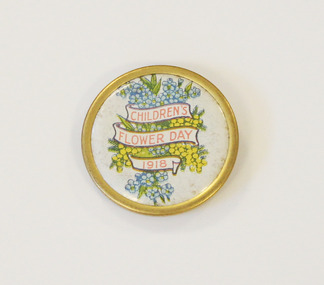
Children's Flower Day 1918 badge, 1918
Cyril Everett Isaac (1884-1865) (MLC for South Eastern 1940-52) was a progressive educator, horticulturist and conservationist. A pioneer of school gardening, Isaac believed in the enlightening, spiritual values of working with the land, and founded the State Schools Horticulture Society in 1910. Following the outbreak of the Great War, Isaac recognised the potential to combine school gardening with humanitarian aid. In 1915, Isaac helped to establish the Young Gardeners’ League, whereby young garden enthusiasts could join for a penny and cultivate plots in their own backyards. These home-grown flowers and vegetables were then sold for the going market rates, and the proceeds went towards supporting the Education Department officers serving in the war and their families. This project culminated in a state-wide flower day show held at Melbourne’s Town Hall on 3 November 1916, known as Children’s Flower Day. Isaac hoped that this special day would encourage children to feel that by ‘growing the flowers they are doing something to help our brave soldiers.’ Originally aiming to raise £10,000, the inaugural Flower Day raised over £32,309 (including revenue from home produce), and was donated to the War Relief Fund. On 9 November, the Dandenong Advertiser reported: “This is a splendid record for the boys and girls of our State Schools, who are so well tutored, and ready and willing to help the British Empire against the enemy.” One month after Flower Day, Isaac enlisted in 58th Battalion of Australian Infantry Forces, and departed for Europe in May 1917. Subsequent Children’s Flower Days were held in 1917 and 1918 in Isaac’s absence, and accounted for 25 per cent of the £445,000 raised by the Education Department’s War Relief Fund. A badge created as a fundraiser for Children's Flower Day in 1918. These badges were sold in public places in order to raise funds for war relief. Round metal badge with celluloid insert that has a printed motif of flowers (wattle and forget-me-not) and three banners with red text.Printed recto: "CHILDREN'S/ FLOWER DAY/ 1918"isaac, cyril everett (1884-1865), children's flower day, world war 1, charity -
 Ballarat Tramway Museum
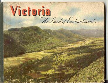
Book, Nu-color-vue or Nucolorvue Productions, "Victoria The Land of Enchantment", c1950
Book with hardcovers, 48 pages titled "Victoria The Land of Enchantment". Sewn in three sections, with a green strip of cloth and self end papers and printed outer paper, sides glued onto board covers. Consists of 43 colour photographs (full and half page) with captions, detailed text, and two black and white photos printed in blue on end covers. Photos of Mt Buffalo, Gippsland lakes, Mornington Beach, Yarra River, Flinders St. station from the Yarra, Collins and Spring St (with two W2's - see image No. 2), Parliament House, Kiewa Hydro scheme, Eildon Weir, Swan Hill Murray River Bridge, Bendigo Post Office, Melbourne Botanical Gardens, Ballarat - Grenville and Sturt St (No. 22 - see image No. 3), Lorne, Yallourn Power Station, Hume Weir, Maroondah Weir, Great Ocean Road, Warrnambool, Portland Beach, A timber train (see image No. 4), Mildura, flax mills, Eastern Geelong and the Prime Ministers Ave, Ballarat. Produced by Nucolorvue Productions, c1950. See also Reg Item 2925 for the same photo of No. 22 and Reg Item 5354 for a postcard. Purchased via eBay site - see attached sheets and packing slip. Purchased 10/2/2005 for A$12.50 including postage, from Virginia Georgopoulos of West Brunswick. eBay sheets and envelope with worksheet file. Has Swains 123 Pitt St, Sydney sticker on bottom left hand corner page 2trams, tramways, ballarat, sturt st, grenville st, bogie trams, geelong, bendigo, melbourne -
 Otway Districts Historical Society
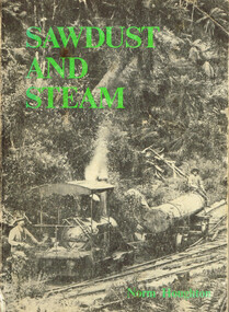
Book, Light Railway Research Society of Australia, Sawdust and Steam. Norman Houghton, December 1975
Sawdust and steam. A history of the railways and tramways of the eastern Otway Ranges. Norman Houghton. IBSN 0 909340 03 X. Soft cover. iv, 106 p.; illus, maps. Melbourne, 1975. Cartography: Alan Strempel.steam and society; norman houghton; railways, east otways; tramways, east otways; tramways, forrest; coastal tramways; -
 Otway Districts Historical Society
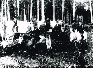
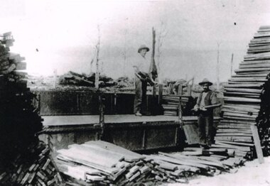
Photograph, Railway Survey Camp, Beech Forest, 4 Apr 1897, 4 April 1897
On the 18th August, 1896, the question of selecting localities for the permanent survey of a narrow-gauge line to Beech Forest from Colac was mooted. Two potential lines were examined. In a memorandum to the Minister for Railways, dated 23rd March, 1897, the Engineer-in-Chief recommended that the eastern and longer route via Lardner's Track be adopted. The second route, while identical from Colac to Gellibrand River, differed. By a more direct route the Beech Forest terminus is reached 5 miles sooner and cost approximately L24,500 less. The direct line would also serve a larger lot of settlers and would obtain a larger lot of traffic than the alternate proposal. The Parlimentary Standing Committee on Railways examined the proposal in situ and recommended that the direct route from Gellibrand to Beech Forest should be adopted and the Lardner's Track route should be abandoned at once.Photograph, Railway Survey Camp, 4 April 1897. Inspection of alternative routes by Parliamentary Committee on Railways.People named in the photograph.beech forest; railway; survey; victorian parliament; calcutt; fraser; e.h. cameron; d. mciville; a. harris; n. mcinnes; j.s. white; j. wood; t. baker; j. gardner; t.g. watson; standing committee; -
 Otway Districts Historical Society
Photograph, R. Preston, Beech Forest: Loading puncheons, c.1914, c.1914
While one of the lesser prime loading points sawn and split timber were loaded at Beech Forest, and a large share of this was brought to the station over two timber tramways that operated between 1904 and 1933. At the eastern end of the railway yard, near the six-ton derrick crane, a wooden tramline curved out the gate and along the road for about 8 km (5 miles) to the co-operative Box Company, known locally as the Box mill, owned by the Victorian Diary Farmers' Co-operative whose purpose was the milling of butter boxes. Other millers also provided timber. Logs were hauled to the mill by horses, and the sawn timber despatched over a tramline that joined the Box mill line about 1.2 km (0.75 miles) along. B/W. Two men loading puncheons (a short post approximately 4 feet [1.2 metres] especially used for supporting a roof in a coal mine) on a NQR wagon at Beech Forest. Note the lack of trees in the background.beech forest; railways; puncheons; -
 Heytesbury District Historical Society Inc.
Administrative record - Minute Book, Waarre Telephone Subscribers, 1960
Excercise book with minutes taken at two meetings held in the Waarre hall in Decemberr 1960 to resolve the problem of the local telephone exchange losing its current operator. The minutes note the majority of people who lived on Eastern Creek Rd. and Waarre Rd. at this time. Families included. Bottrel, Bramley, Lloyd, Fitzpatrick, McKenzie, Clarke, Welton, Younis, Meek, Wills, Shiells, Jeffery, Wilson, Giblett, Webb, Tranter, Stevens, Meek. The book contains a letter written to the PMG and a response. The situation was resolved when Sylvia Fitzpatrick agreed to become the telephonist and for the exchange to be relocated from the home of Roy and Minnie Ford to the Home of Jim and Sylvia Fitzpatrick. School Exercise bookWaarre Telephone Subscriberscommunication, telephone, community action -
 Heytesbury District Historical Society Inc.
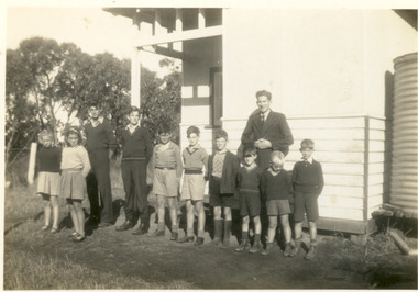
Photograph - Eastern Creek SS Teacher and pupils C. 1942
Black and white photograph of pupils and teacher (Jim Crowley) outside the Eastern Creek SS. No 4595 Families include Giblett, Webb, Black and White photographeastern creek, school, education