Showing 67 items matching " mt warrenheip"
-
 Federation University Historical Collection
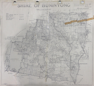
Map, Shire of Buninyong, c1970
... lychfield scotchman's navigators warrenheip scotsburn mt doran ...The Shire of Buninyong was located on the southern side of Ballarat.Two maps of the Shire of Buninyong. .1) Map showing the County divisions, township boundaries, Railway line, State Forest boundary, riding boundary and shire boundary. Identifying words have been added in red and green texta. .2) Shire of Buninyong Parish Plan. Includes Buninyong, Clarendon, Narmbool, Enfield, Lychfield, SCotchman's, Navigators, Warrenheip, Scotsburn, mr Doran, Durham Lead, Cambrian Hill, Napoleons, Garibaldi, Mt Clear, Lal Lal, Bonshaw.1) B.I.A.E., St Martin's, cemetery, mt Buninyong, mt Innes, rly stn shire of buninyong, buninyong, clarendon, narmbool, enfield, lychfield, scotchman's, navigators, warrenheip, scotsburn, mt doran, durham lead, cambrian hill, napoleons, garibaldi, mt clear, lal lal, bonshaw, state forest, elaine, elaine north, cargerie, grenville, mt mercer, millbrook, wallace, yendon, canadian, kaolin deposits, mount helen campus -
 Federation University Historical Collection
Document, Keith E. Rash, Ballarat Gold Discovery, c1970
Three handwritten pages relating to gold discovery at Ballarat.ballarat, gold discovery, smythesdale, bunninyong, warrenheip, geology, archibald yuille, pyrenees, clunes, herbert swindles -
 Ballarat Tramway Museum
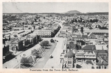
Photograph - Illustration, "Panorama from the Town Hall", c1907
... the Town Hall towards Mt Warrenheip. Ballarat illustrations Sturt ...Set of two views from an illustrated publication on Ballarat. 1 - "Panorama from the Town Hall" - with three ESCo trams in the view, though very few pedestrians or other vehicles. High lights Mount Warrenheip. 2 - A view of Lake Wendouree - Fairyland.Yields information about Sturt St from the Town Hall towards Mt Warrenheip.Illustration cut from a magazine or publicationballarat, illustrations, sturt st, lydiard st, esco, mount warrenheip, lake wendouree -
 Buninyong & District Historical Society
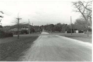
Photograph - Original B/W Photograph, Scott St looking east from intersection with Warrenheip St, 19th July 1993
Scott St was originally an alternative cart track down from Mt. Buninyong.This streetscape is of historic and social significance.Original B/W photo of Scott St looking east from its intersection with Warrenheip St.scott st, warrenheip st, streetscape, mount buninyong -
 Federation University Historical Collection
Map, Ballarat Goldfield, c1898
This map shows geological features, suggests the last basalt flow, and includes alotments and names of Mining Companies. Although this map has no date on it the Ballarat Industrial School is used for dating purposed. The Ballarat Industrial School ran from 1869-1879, but the term Ballarat Industrial School Reserve was still in use in 1898 and possibly beyond.Geological Map of Ballarat with 3 holes in the left hand side. The map indicates the position of Lake Wendouree, Township of Warrenheip, Ballarat East, Industrial School Reserve, Winters Swamp, Police Paddock, Wyndholm Premptive Right (Salton and Waldie), Black Hill, Vale Park Reserve, Pennyweight Hill, Little Bendigo, Black Swamp Lead, monte Christo Reef, Chinaman's Gully, Miners Rest, Pincotts Dam, Northumberland Gully. It also show the following goldmining companies: City of Ballarat, Kohinor, Hand and Band, Great North West, Northern Junction, Kneeshaw, Rossers Freehold, Silurial.ballarat, warrenheip, lake wendouree, ballarat east, winters swamp, winter swamp, wyndholm premptive right, cemetery, vale park reserve, little bendigo, kneeshaw co., industrial school reserve, kirks dam, pincotts dam, black hill, wombat hill, dead horse gully, miners rest, mt rowan, salton and waldie, rose hill co, great north west no 1, rose's freehold co, hand and band co, police reserve, police paddock, mount rowan, ballarat industrial school reserve, market reserve, winter's swamp, kneeshar co, monte cristo line of reef, chinaman's gully or black snake, milkmaid's gully, ballarat gold field, bakery hil lead, old gravel pits lead, golden point lead, eureka lead, miner's rest, yarrowee creek, leigh creek, black swamp lead, yorkshire reef, nil desperandum reef, cockatoo lead, hit or miss gully, herbert werner frederick de nully, pennyweight hill, esmond's lead, ash's lead, nightingale lead, john bull gully, gladstone reef, whitehorse reef, petticoat creek, pincott's dam, frenchman's gully, tim's crushing plant, jenkin's gully, california gully, drake's creek, sulton and waldie, ballarat undustrial school, ballarat & mariborough railway -
 Buninyong & District Historical Society
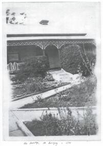
Photograph - Black and white copies of photographs of "The Hermitage", Photographs of "The Hermitage" home of the Poynton family
The Poynton family arrived in Buninyong in 1896 and established a property in Warrenheip Street followed by the purchase of "The Hermitage" on the slopes Mount Buninyong for the succeeding generations to supply cream, potatoes, pigs, peas and gooseberries to the local community. Silas Poynton was appointed a Trustee of the Buninyong Methodist Church in 1914 and family life revolved around the Church and its activities for many years.This home represents the life of the early families in the district, their agricultural activities and their community links. Various views of "The Hermitage" circa 1920s and a copy of the contract for the purchase"The Hermitage" Mt. Buninyong c. 1920poynton family, "the hermitage", mount buninyong, methodist church -
 Buninyong & District Historical Society
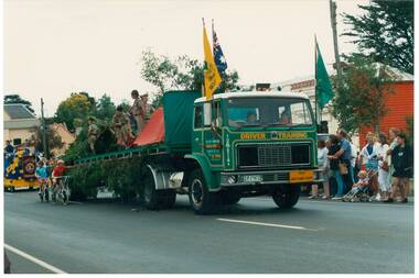
Photograph - Colour photograph, 1989 Gold Festival Procession, 1st Mt. Clear Scouts on truck in front of Old Library, Warrenheip St, 1989 Gold Festival Procession, 1st Mt. Clear Scouts on truck
Festival, socialColour photo, 1989 Gold Festival Procession, 1st Mt. Clear Scouts on truck in front of Old Library, Warrenheip St.gold festival, boy scouts