Showing 101 items
matching nepean road/highway
-
 City of Moorabbin Historical Society (Operating the Box Cottage Museum)
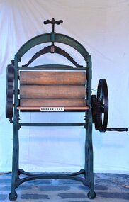
Functional object - Laundry equipment, Mangle, c1900
The mangle was used in the laundry at Key's, Exchange Hotel. This large, iron framed, manual, machine with 3 cylinders for rolling and pressing washed clothes was a prominent and necessary piece of equipment used by early settler women in Moorabbin Shire 1800 to mid 1900sThis large Mangle was used at The Exchange Hotel, Nepean Highway, Cheltenham , built in 19thC , now known as The Tudor Inn.A large, iron framed, manual, machine with 3 cylinders, for rolling and pressing washed clothes, connected by cogs manually operated by turning a side wheel with a large crank handle.On an oval plate at base of iron frame 'W. Summerscales / & Sons / Keighley Englandclothing, brighton, moorabbin, linen, washing machine, bentleigh, market gardeners, laundry equipment, mangle, early setters pioneers -
 City of Moorabbin Historical Society (Operating the Box Cottage Museum)
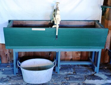
Functional object - Laundry Equipment, wooden double wash trough, c1900
c1900 This large wooden double wash trough with 'Acme' clothes wringer came from the old 'Exchange Hotel' now known as The Tudor Inn, Nepean Highway, Cheltenham.The Exchange Hotel, Point Nepean Road, Cheltenham, (now The Tudor Inn Hotel Nepean Highway,) was built in the late 1800s. By 1915 it was a prominent meeting place for early settler families of Moorabbin Shire. The trough is typical of those used in large laundries c1900 The ACME wringers were used in most households until c1960 Wooden, double washing trough, on a wooden stand c1900moorabbin, cheltenham, brighton, nepean highway, exchange hotel, the tudor inn hotel, clothing, early settlers, pioneers, market gardeners, acme manufacturing company, glasgow. -
 City of Moorabbin Historical Society (Operating the Box Cottage Museum)
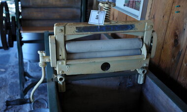
Functional object - Laundry Eqipment , 'ACME' clothes wringer, mid 20thC
This ACME portable clothes wringer could be attached to a wash trough or hand washing machine to remove excess water from the washing. It was much less cumbersome that the earlier Mangles used for this purposeMost homes of 20th C in City of Moorabbin would have had one of these ACME wringers . It greatly eased the washday burden of the women. The Exchange Hotel Nepean Highway Cheltenham was a well established meeting place for Moorabbin Shire settlers by 1915A metal clothes wringer with side hand crank and 2 rollers that could be attached by screw clamps to a wash trough or washing machine for removing excess water from washing. The pressure of 2 rollers was controlled by a screw on the top of machine that could be loosened or tightened according to the material being passed through.ACME 14 INCH / on hand crank is list of patents for Great Britain, USA, Aust. NZ, Germany, Belgium, Sweden moorabbin, bentleigh, cheltenham, laundry equipment, washing, washing mangles, washing machines -
 City of Moorabbin Historical Society (Operating the Box Cottage Museum)
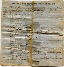
Certificate - Certificate of Marriage for Stephen Tuck & Catherine Draper, 1857
Stephen Tuck was one of the original settlers of the district, he had a market garden on Nepean Highway, Cheltenham. The family continued the market garden for over 70 years. It was subdivided and sold as residential blocks in 1940. Original Marriage Certificate of Stephen Tuck and Catherine Draper, in Moorabbin on 19 January 1857.stephen tuck, cheltenham, market gardens, city of moorabbin, land sales, marriage, catherine draper -
 City of Moorabbin Historical Society (Operating the Box Cottage Museum)
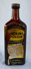
Domestic object - Watkins Polish, J. R. Watkins Co (USA), 20thC
The J. R. Watkins Co. opened its first overseas branch in Australia in 1935. The J. R. Watkins built a large factory at Highett on a six acres on the east side of Nepean Highway (no. 1123) in 1954. The J. R. Watkins company was founded in 1868 in Plainview, Minnesota USA, moving to Winona in 1885, by J. R. Watkins.Example of industry in the City of Moorabbin.Amber glass bottle with a metal screw on lid. A paper label is on the front of the bottle 'Watkins Polish" printed in yellow, black and white.PRINTED ON LABEL: 11 Fluid ounces - WATKINS POLISH - Gives a hard dry lustre excellent for Dusting For cleaning, dusting and polishing furniture, pianos, woodwork, linoleum, hardwood floors and all polished surfaces. Directions: If the article to be polished is dirty or gummy, clean it by washing with mild soap and warm water. Apply Watkins Polish with a damp, soft cloth (Dampened with water and wrung almost dry). The Polish may be poured on the damp cloth or on the surface to be polished. In either case rub it all with a dry cloth to obtain a high polish. When dusting, dampen the cloth with Watkins Polish - it keeps down the dust and gives a lustre which is neither greasy not gummy. The J. R. Watkins Co. Melbourne - Sydney - Adelaide - Kogarah EMBOSED ON BOTTLE: "The J.R.Watkins co. Made in Australia" the j. r. watkins co, highett, polish -
 City of Moorabbin Historical Society (Operating the Box Cottage Museum)
Book - A Journey of Faith - The Stained Glass Windows of St Paul's Bentleigh Holy Trinity Parish, by Patrick Ferry, 2015
St Paul's Church is in Jasper Road, Benlteigh. A foundation stone reads " This stone symbol of Christ, Chief corner stone of the church was blessed and set by His Grace Archbishop Simonds 13th November 1960, T O'Sullivan P.P. S. J. Morgan and Associates Architect H.P. Yunken Pty Ltd Builder". The stained glass windows were commissioned by Father Timothy O'Sullivan and the artist was Alan Sumner. The window were progressively installed from 1961, and took nearly 20 years to complete.St Paul's Catholic Church Bentleigh was integral to the spiritual well being and social life of the early settlers.A book about the stained glass windows in St Paul's Catholic Church in Jasper Road, Bentleigh - containing photos and diagram.city of moorabbin, county of bourke, shire of moorabbin, market gardeners, nepean highway, st paul's catholic church, bentleigh, jasper road, religion -
City of Moorabbin Historical Society (Operating the Box Cottage Museum)
Pamphlet - St Finbar's Parish Church, East Brighton - Celebrating 150 Years 1848-1998, 1998
... St Finbar's Roman Catholic Church corner of Nepean Highway... Finbar's Roman Catholic Church corner of Nepean Highway and Centre ...St Finbar's Roman Catholic Church corner of Nepean Highway and Centre Road, East Brighton.St Finbar's Roman Catholic Church East Brighton was erected in 1871 and was integral to the spiritual well being and social life of the early settlers.Four page AO5 brochure inviting people to join in historic 150 year celebration. Contains brief history of the Parish of St Finger's East Brighton.early settlers, parish of moorabbin, city of moorabbin, county of bourke, shire of moorabbin, were j.b., market gardeners, nepean highway, east brighton, st finbar's parish, centre road, religion, roman catholic -
City of Moorabbin Historical Society (Operating the Box Cottage Museum)
Booklet - Cheltenham Church of Christ - Our Heritage - The History of the Cheltenham Church of Christ, by K. G. Hilbig and G. L. Daff, 1970
Cheltenham Church of Christ was opened in 1878 and is still in use today. Built on Chesterville Road, Cheltenham.Cheltenham Church of Christ was opened in 1878 and was integral to the spiritual well being and social life of the early settlers.Booklet 10 pages with typed textearly settlers, parish of moorabbin, city of moorabbin, county of bourke, shire of moorabbin, market gardeners, cheltenham, nepean highway, church of christ cheltenham, religion, chesterville road -
City of Moorabbin Historical Society (Operating the Box Cottage Museum)
Booklet - Souvenir History of the Church of Christ Cheltenham - 80th Anniversary May 2 & 3, 1937, by J. Ernest Allan, 1937
Cheltenham Church of Christ was opened in 1878 and is still in use today. Built on Chesterville Road, Cheltenham.Cheltenham Church of Christ was opened in 1878 and was integral to the spiritual well being and social life of the early settlers.Booklet 19 pages with typed text and photosearly settlers, parish of moorabbin, city of moorabbin, county of bourke, shire of moorabbin, market gardeners, cheltenham, nepean highway, church of christ cheltenham, religion, chesterville road -
City of Moorabbin Historical Society (Operating the Box Cottage Museum)
Booklet - One Hundred Years - Church of Christ Chesterville Road, Cheltenham 1857-1957, by J. Ernest Allan, 1957
Cheltenham Church of Christ was opened in 1878 and is still in use today. Built on Chesterville Road, Cheltenham.Cheltenham Church of Christ was opened in 1878 and was integral to the spiritual well being and social life of the early settlers.Booklet 12 pages with typed text and photosearly settlers, parish of moorabbin, city of moorabbin, county of bourke, shire of moorabbin, market gardeners, cheltenham, nepean highway, church of christ cheltenham, religion, chesterville road -
 Bayside Gallery - Bayside City Council Art & Heritage Collection
Photograph, Department of Crown Lands and Survey, Victoria, Brighton, Elwood and Elsternwick, c. 1965-71
... . The main roads shown include North Road at the top, Nepean Highway.... The main roads shown include North Road at the top, Nepean Highway ...The Department of Crown Lands and Survey (1857-1983) was responsible for the administration of survey and mapping and the sale, occupation and management of crown land throughout its existence. This aerial photograph shows parts of Brighton, Elwood and Elsternwick and was taken circa 1965-71.brighton, department of crown lands and survey, aerial photograph, bayside, port phillip bay, map, cartographic material, elwood, elsternwick, elsternwick park, elwood tram depot, elwood pier, new street, glen huntly road, st kilda street, nepean highway -
 Bayside Gallery - Bayside City Council Art & Heritage Collection
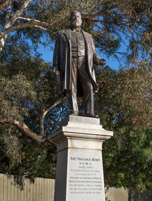
Sculpture, Margaret Baskerville, Sir Thomas Bent, 1913
Arguably Margaret Baskerville’s most famous work, the bronze statue of politician and land speculator Sir Thomas Bent was Baskerville’s first public commission and a significant turning point in her career. Originally located in the centre of the Nepean Highway, in Brighton, it became somewhat of signpost for many Melbournians until it was relocated to the corner of Bay Street in 1980.The statue of Sir Thomas Bent is of historic and social significance to the State of Victoria. The statue is historically significant for commemorating Bent's long, active and infamous political career in Victoria. He was responsible for many important speculative ventures both within his electorate and in the wider context of Victoria. Although not without thought for personal gain, Bent was a committed advocate of public utilities, railways, roads, tramways and gasworks. The statue is historically significant as the first large public commission given to a woman sculptor in Victoria. This work helped the sculptor, Margaret Baskerville, preserve her name as Victoria's first professional woman sculptor. The statue is socially significant as testimony to the late nineteenth century land boom and the financial and political corruption and scandals that accompanied it. https://vhd.heritagecouncil.vic.gov.au/places/12614bronze and granite thomas bent, politician, mayor, premier, bust, sculpture, margaret baskerville, speaker, member of parliament, member of lower house, local government, councillor, brighton, public art, bayside -
 Glen Eira City Council History and Heritage Collection
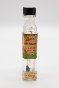
Kuraburn bottle
This Kuraburn Bottle is part of a Sanax First Aid Case which was used at the the former Carnegie Senior Citizens' Centre. The centre was located at 314 Neerim Road, Carnegie. When the Neerim Road facility closed, its activities were moved to the Carnegie Library and Community Centre. For Occupational Health and Safety reasons, Council no longer maintains first aid kits at senior citizens' centres. Clear glass bottle with two paper labels on narrow side. One red, green, white and black label with Sanax branding, one red and white label at base of bottle with address and contact details. Black plastic screw-top lid with a section missing. Bottle has been decanted however some residue remains. Small cork stopper contained within bottle."Sanax" KURABURN / FOR THE TREATMENT / OF BURNS / SCALDS AND / SUNBURN / THE SANAX CO. / 849-51 NEPEAN HIGHWAY / MOORABIN / TEL XU 2651 / Left side of label: Directions: Dab on lightly, and repeat in two hours if necessary. Applied early, it prevents blistering. Right side of label: Allow to dry on the skin before putting on wearing apparel, to avoid staining the clothes. 223-5 BAY ROAD, / SANDRINGHAM, S.8 / VICTORIA / Phone: 98-1604 -
 Glen Eira City Council History and Heritage Collection
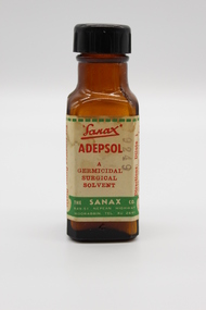
Adepsol Bottle
This Adepsol Bottle is part of a Sanax First Aid Case which was used at the the former Carnegie Senior Citizens' Centre. The centre was located at 314 Neerim Road, Carnegie. When the Neerim Road facility closed, its activities were moved to the Carnegie Library and Community Centre. For Occupational Health and Safety reasons, Council no longer maintains first aid kits at senior citizens' centres. Brown glass bottle with red, green and white paper label with Sanax branding, and usage directions. Black plastic screw-top lid. Bottle has been decanted however some white powder residue remains. "Sanax" ADEPSOL/ A GERMICIDAL / SURGICAL / SOLVENT / THE SANAX CO. / 849-51 NEPEAN HIGHWAY / MOORABIN / TEL XU 2651 / Directions: Dilute 1 in 4 with warm water for bathing Wounds, dab dry with absorbent cotton, then apply Germicide and dressing. For removing Germs, Grease, and Dirt from Wounds and Burns before finally dressing Wounds. -
Glen Eira City Council History and Heritage Collection
Document (Item) - Newspaper (digital), Caulfield Contact
The Caulfield Contact was the official newspaper of the City of Caulfield from 1976-1994. The City of Caulfield was the Municipal Council for an area of the South Eastern suburbs of Melbourne, including Brighton East, Carnegie, Caulfield, Elsternwick, Gardenvale, Glen Huntly, McKinnon, Murrumbeena, Ormond and St Kilda East. Following Amalgamation of City of Caulfield and parts of the City of Moorabbin in 1994, the Caulfield Contact was followed by the Glen Eira News. Includes references to the following: Children's Neighbourhood Centre Caulfield; Fire destroyed Caulfield Park Bowling Club; Naming of Harleston Park; Home Handyman Service; Profiles Councillors Peter Baitz, Ron Walters; Carnegie-Glenhuntly Football Club formed Council drops approval of rail crossings over Neerim and Glenhuntly Roads; Profiles Councillor Alwyn Samuel, Glen Richards; First stage of Nepean Highway widening; Minister approved re-subdivision; Council spills; Exciting development of Caulfield Park; Profiles Councillor Max Blair, Councillor Brian Rudzki; Tram shelter classified by National Trustcity of caulfield, caulfield, glen eira, city of glen eira, caulfield contact, children's neighbourhood centre caulfield, fire destroyed caulfield park bowling club, naming of harleston park, home handyman service, profiles councillors peter baitz, ron walters, carnegie-glenhuntly football club formed, council drops approval of rail crossings over neerim and glenhuntly roads, profiles councillor alwyn samuel, glen richards, first stage of nepean highway widening, minister approved re-subdivision, council spills, exciting development of caulfield park, profiles councillor max blair, councillor brian rudzki, tram shelter classified by national trust -
 Brighton Historical Society
Coat, Dustcoat, c.1948
Dust coat worn by Mr Frederick Alister Jennings when he managed a family grocery store circa 1948 at 510 Point Nepean Road, East Brighton. Frederick was born at Nagambie, Victoria in 1909 and died in Brighton in 1979. He was the son of Hugh Edwin Jennings and Alice Constance Warren. He married Margaret Jean Hughes in 1934 and served in the Second World War. He lived at 1 Valda Grove Brighton. Frederick was a commercial traveller as well as his time spent managing the store in Point Nepean Road. It is believed this coat dates from his time at the store c1948 - 1955. The store was owned for many years by his father-in-law W. G. Hughes and was one of a group of shops near the corner of Centre Road. In 1944-45 the group of shops included Fletcher’s fuel merchants, a haberdasher, butcher, fruiterer, grocer, Brighton East post office, a ladies’ hairdresser and Hughes’ grocer. In 1950 Hughes’ grocery store was between a service station and the Commercial Bank on what had been renamed Nepean Highway. The business was sold to G. S. Maynard, grocer, sometime before 1960.Unlined dustcoat of beige cotton. Fastens centre front with three brown plastic buttons. Two large patch pockets. Separate cloth belt with metal buckle. Signs of wear and mending. .1 - coat .2 -beltGarment label reads: APEX (RLG.) Dust Coat DEPT. MYER STORE for MEN. MELBOURNE & ADELAIDEdustcoat, occupational dress, grocer, hughes grocery store, brighton, frederick alister jennings -
 Brighton Historical Society
Bed jacket, circa 1955
This bed jacket was crocheted for Carmela Materia (1931-2018) by her mother, Giuseppa Auditore, around the time they emigrated from Italy to Melbourne. Both women were longtime Brighton locals, residing in the area from the 1950s until their deaths. Carmela Auditore was the first woman from her home village of Scaletta, Italy to emigrate to Australia. Setting sail alone in 1950 at the age of 19, she joined her brother John and uncle Frank in McCallum St, Brighton. Frank had arrived some years earlier and had spent the duration of the First World War in an internment camp. John worked at the Brighton Case Company, a box manufacturer on Nepean Highway, and paid for her passage. Carmela found a job sewing children's clothing at Drummonds, a small factory in Church St. Working eight hours a day, five days per week, netted her a weekly wage of three pounds. To earn a little extra, she washed dishes at a St Kilda Road restaurant for ten shillings a shift. Her parents, Salvatore and Giuseppa Auditore, joined her in Brighton in 1952. They rented a house behind an antique shop in Bay Street. Salvatore had been a fisherman in Scaletta, but quickly adapted to the job he found helping around the Garage at Brighton Motors in Male Street. On 14 February 1953, Carmela married her sweetheart, Salvatore Materia, at St James Catholic Church in Gardenvale. Salvatore had been living with his aunt in Well Street and worked on the wharves. Both Carmela and Salvatore were hard workers. They owned a fruit shop in Church Street where Woolworths now stands, and years later Carmela recalled the familiar 6am tap on her window each morning when her husband returned from the market. On dark winter mornings, she felt as if her hands would freeze as she helped Salvatore unload cold cabbages and cauliflowers from his truck. They later owned a shop in Ludstone Street in Hampton. After Salvatore died suddenly at the age of 48, Carmela returned to sewing, working at the Willow Fashions knitting mill in Gardenvale. She later went into partnership with her sister and brother-in-law, this time in the delicatessen business. Her parents, Giuseppa and Salvatore, spent the rest of their days with Brighton. Carmela recalled her father cheerfully walking the streets, greeting people by name. He knew everybody. He loved being in Australia and enjoyed life to the last, insisting on having bread and wine on the table at every meal.Cream crocheted wool bed jacket. Loose around bust with wide sleeves and open sides. Fastens at collar with thin braided ties, and at waist with two pearlescent plastic buttons.bed jacket, migration, 1950s, carmela auditore, carmela materia, giuseppa auditore -
 City of Kingston
Photograph - Black and white, c. 1958
... with other construction works on Nepean Highway and South Road... with other construction works on Nepean Highway and South Road ...Moorabbin station sits on the Frankston line which first opened in 1882 when the line was extended from Mordialloc. Moorabbin station opened in 1881 and was originally called South Brighton station. It was renamed Moorabbin station in 1907. In 1958 the station was relocated below street level which coincided with other construction works on Nepean Highway and South Road. This image is part of a larger collection of images from the Public Transport Corporation displaying train stations and streetscapes in what is now the City of Kingston.Black and white photograph showing excavations for Moorabbin station to be moved below street level. Stamped in blue ink on reverse: COPYRIGHT / Public Transport Corporation / For re-ordering photographs / Please quote negative No M6004 / Enquiries C/- PTC Photographic Unit / Telephone switchboard 619 111moorabbin, railway station, construction works, suburbs, nepean highway -
 City of Kingston
Photograph - Black and white, c. 1957
Copy black and white photograph of railway level crossing on Nepean Highway Moorabbin before excavations for the below ground rail crossing. The level crossing gates are closed and five cars are waiting, while other cars can be seen coming in the opposite direction. A woman with a child in a pram is walking along the road, and a number of men, probably construction workers, are standing behind a barricade on the right hand side of the road. Gilbey's Gin distillery is visible in the background. TCopy black and white photograph of railway level crossing on Nepean Highway Moorabbin before excavations for the below ground rail crossing. The level crossing gates are closed and five cars are waiting, while other cars can be seen coming in the opposite direction. A woman with a child in a pram is walking along the road, and a number of men, probably construction workers, are standing behind a barricade on the right hand side of the road. Gilbey's Gin distillery is visible in the background. Handwritten in blue ink on reverse: 57-465C Handwritten in red ink on reverse: 71% A red circle has been drawn around all handwritten text.moorabbin, railway station, railway crossing, suburbs, cars, local production -
 City of Kingston
Photograph - Black and white
... This photograph depicts the road diversion on Nepean...Black and white photograph of road diversion on Nepean... of road diversion on Nepean Highway, Moorabbin to allow ...This photograph depicts the road diversion on Nepean Highway that was implemented to allow construction of the railway line underneath the Nepean Highway at Moorabbin. An "Allourie" Cheese, Honey Canned Ham van is prominent on the left of the image, the railway gates are central and the old Moorabbin Station is visble. Beyond the dates, pedestrians are visible crossing the Nepean Highway. This image is part of a larger collection of images from the Public Transport Corporation displaying train stations and streetscapes in what is now the City of Kingston.In 1958 excavations began for the removal of the level crossing gates at the southern end of the Moorabbin shopping centre on Nepean Highway. The station was also lowered below ground. A diversion route was created to enable the flow of traffic in both directions along the highway.Black and white photograph of road diversion on Nepean Highway, Moorabbin to allow the construction of the railway line below the Nepean Highway at Moorabbin and also to trench the station. This image is part of a larger collection of images from the Public Transport Corporation displaying train stations and streetscapes in what is now the City of Kingston.White adhesive dot sticker: Printed black 199 Handwritten in red ink: 80% Handwritten in black ink on yellow Post-It Note: [indecipherable] 199 - Diversion for Crossing Stamped in blue ink: COPYRIGHT Public Transport Corporation, For reordering photographs, Please quote negative No m 5687, Enquiries C/- PTC Photographic Unit, Telephone switchboard 619 1111railway crossing, railway station, city of moorabbin -
 City of Kingston
Photograph - Black and white, c. 1970
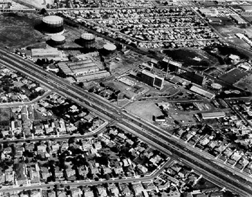
The Highett Gas Works were a landmark along the Nepean Highway for many years. With the cessation of the gasification of coal and the introduction of natural gas to Victoria, the gas holders were demolished and the Sir William Fry Reserve was developed on the southern end of the site. The Gas and Fuel redeveloped the northern end of the site with modern offices and laboratories for the organisation's scientific services. At this time, the chimney and retort house were retained.The Highett Gasworks had its beginning in 1939 operated by the Central Brighton and Moorabbin Gas Co Ltd. The company had expanded its gas production facilities to Highett where it had purchased 45 acres of land adjacent to the Melbourne-Frankston railway line. The first gasholder was erected on the Highett site in 1927 and connected with high pressure mains to the Brighton Gas Works. In 1939 the building program including gasometers, the vertical retort house and coal store was completed and gas making commenced. Its area of supply covered approximately 70 square miles and included the municipalities of Brighton, Sandringham, Moorabbin, Mordialloc, Chelsea and part of Dandenong. The Gas and Fuel Corporation eventually took over operations and with the disaggregation and privatisation of the organisation, the site was eventually closed c. 2002.Black and white aerial photograph featuring the Highett Gas Works with gasholders and retort house. In the top right-hand corner, a former Highett Primary School on Graham Road can be viewed. Photograph includes Bay Road, Royal Avenue, Princess Avenue and Jackson Road (Highett) and Alfred, Turner and Sandford Streets (Moorabbin).Handwritten in black ink: [indecipherable] in a circle Handwritten in red ink: 70% Four velcro display adhesivesgasification of coal, gas and fuel corporation of victoria, gasholders, highett, moorabbin, utilities -
 City of Kingston
Photograph - Black and white, c. 1930
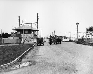
... Level crossing Cars Roads Nepean Highway Black printed text ...This image is part of a larger collection of images from the Public Transport Corporation displaying train stations and streetscapes in what is now the City of Kingston.The Nepean Highway is a major highway running through the City of Kingston. This image is one of many that depicts its importance to the local community as it undergoes many changes over time.Black and white photograph depicting the level crossing at Moorabbin. While the gates at the level crossing are open, two cars are making their way across the crossing, while a third car is parked on the side of the road, in front of a large billboard/hoarding for ham and bacon products. There is a man standing on the road as if watching the cars go through the crossing. The road appears to be unsealed. Black printed text on a round white sticker adhered to the reverse: 148 Handwritten in red ink: 60% Blue ink stamped on reverse: COPYRIGHT / Public Transport Corporation / For re-ordering photographs / Please quote negative No ADU907 / Enquiries C/- PTC Photographic Unit / Telephone switchboard 619 111moorabbin, trains, railway crossing, level crossing, cars, roads, nepean highway -
 City of Kingston
Photograph - Black and white, c. 1930
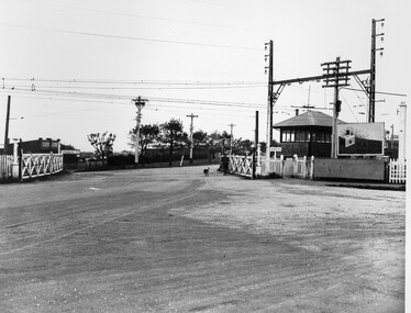
This image is part of a larger collection of images from the Public Transport Corporation displaying train stations and streetscapes in what is now the City of Kingston.The Nepean Highway is a major highway running through the City of Kingston. This image is one of many that depicts its importance to the local community as it undergoes many changes over time.Black and white photograph depicting railway crossing at Nepean Highway Moorabbin. The level crossing gates are open and a man is walking through with his dog. To the right of the crossing is a billboard/hoarding promoting what appears to be a brand of radio/wireless.White round sticker with indecipherable black printed text which has been scribbled over with black pen. White round sticker with black printed text: 175 Handwritten in red ink: 50% Blue ink stamped on reverse: COPYRIGHT / Public Transport Corporation / For re-ordering photographs / Please quote negative No ADV 903 / Enquiries C/- PTC Photographic Unit / Telephone switchboard 619 111moorabbin, trains, railway crossing, level crossing, nepean highway -
 City of Kingston
Photograph - Black and white, c. 1930
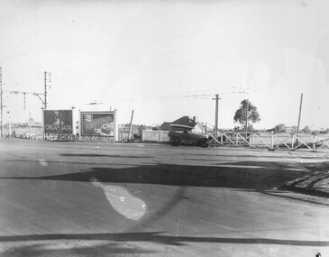
This image is part of a larger collection of images from the Public Transport Corporation displaying train stations and streetscapes in what is now the City of Kingston.The Nepean Highway is a major highway running through the City of Kingston. This image is one of many that depicts its importance to the local community as it undergoes many changes over time.Black and white photograph of the level crossing at Neapean Highway Moorabbin. Photograph is a slightly side view, with a blurred image of a car approaching the level crossing. The gates are closed. To the left of the image is a pair of billboards. The billboard on the left is promoting Creamoata, a New Zealand brand of oats, and the billboard on the right is promoting Kraft cheese.White round sticker on reverse with black printed text: 147 Handwritten in red ink on reverse: 100% Blue ink stamped on reverse: COPYRIGHT / Public Transport Corporation / For re-ordering photographs / Please quote negative No ADV 1030 / Enquiries C/- PTC Photographic Unit / Telephone switchboard 619 111moorabbin, level crossing, railway crossing, cars, advertising, nepean highway -
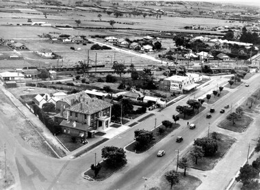 City of Kingston
Photograph - Black and white, c. 1930
... of Nepean Highway and South Road. Moorabbin Council Chambers... of Nepean Highway and South Road. Moorabbin Council Chambers ...During the 1930s Moorabbin was an area with open grasslands, still often used for market gardening. The development of the city (and, later, suburb) can be seen emerging from the railway station.The Nepean Highway is a major highway running through the City of Kingston. This image is one of many that depicts its importance to the local community as it undergoes many changes over time.Black and white photograph of aerial view of intersection of Nepean Highway and South Road. Moorabbin Council Chambers are situated on the corner with the library, old shire building, Moorabbin railway station, St David's Anglican Church market gardens and open paddocks in the background.White round sticker on reverse with black printed text: 143 Handwritten in red ink on reverse: 156% / k000786moorabbin, council, railway station, railway, suburbs, paddocks, nepean highway -
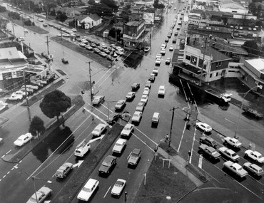 City of Kingston
Photograph - Black and white, c. 1950
... of the intersection of Nepean Highway and South Road, taken from above... of the intersection of Nepean Highway and South Road, taken from above ...The image shows a line of traffic travelling along South Road in response to traffic light signlas while an increasing number of cars are banking up along Nepean Highway, also in response to traffic light signals.This image provides a strong contrast to images from earlier eras of the same intersection. The amount of traffic has increased enormously as well as commercial development.Black and white photograph with an aerial view of the intersection of Nepean Highway and South Road, taken from above the Moorabbin Council Chambers.Handwritten in black ink Pic [indecipherable] / 1000 Handwritten in red ink: 150%moorabbin, traffic lights, cars, nepean highway -
City of Kingston
Photograph - Colour, 31 January 1993
Patterson Lakes is a suburb in the City of Kingston that is built one kilometre upstream of the mouth of the Patterson River. The area is bordered by the Patterson River and Eel Race Drain which enters the Kananook Creek. The suburb consists predominantly of newer housing developments and the tidal canal system of the development joins Port Phillip Bay. Patterson Lakes and the Kananook Creek were previously part of the extensive Carrum Carrum Swamp. The area was once a source of fish and eels for the Mayone-Bulluk clan of the Bunurong people. Over time the area was drained and in 1973 investigations commenced into the development of a unique residential area that would be built adjacent to canals and waterways. It was originally proposed to be known as "Gladesville". The development would give the suburb's homeowners access to Port Phillip Bay "from their back door". Circa 1974, the area was rezoned from rural to residential and named Patterson Lakes. Development has been continuous since the 1970s with construction of residential housing, schools, shopping centres, marinas, a hotel and library.Laminated colour aerial photograph of the Carrum and Patterson Lakes region within City of Kingston. This 1993 image includes Patterson River Secondary College, Roy Dore Reserve, Kananook Creek and Nepean Highway. The railway line can be seen as it veers inland from Eel Race Road, Seaford. The section of Ocean Reef Drive and Palm Beach Drive in Patterson Lakes appears to be a recent development with many spare blocks and new houses under construction.Black typed lettering on white adhesive label: 31.1.93 Black typed lettering on white adhesive label: 27E/7140 31/1/93 12.55 pm Black typed lettering on white label: 7140 Yellow round adhesive label located on left sidepatterson lakes, seaford, kananook creek, carrum carrum swamp, canals and waterways -
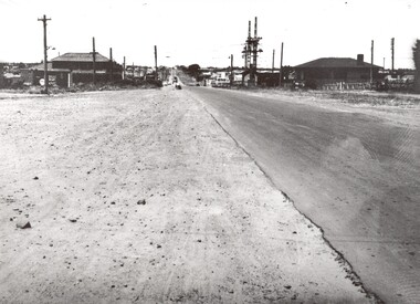 City of Kingston
Photograph - Black and white, c. 1950
... Road, Moorabbin, viewed from Nepean Highway. ..., Moorabbin, viewed from Nepean Highway. Photograph Black and white ...This image shows a sealed road running along South Road, although with a wide gravel shoulder. The railway crossing gates were hand operated. This image is one of many in the collections that focuses on the railway. The development of the railway was crucial to the ongoing development of the area. Community life often sprang up along and beside the railway.Black and white photograph of the railway crossing at South Road, Moorabbin, viewed from Nepean Highway. Handwritten in blue ink on reverse: 217 Handwritten in red ink on reverse: 80%moorabbin, railway, railway crossing -
City of Kingston
Photograph - Colour, c. 1993
Patterson Lakes is a suburb in the City of Kingston that is built one kilometre upstream of the mouth of the Patterson River. The area is bordered by the Patterson River and Eel Race Drain which enters the Kananook Creek. The suburb consists predominantly of newer housing developments and the tidal canal system of the development joins Port Phillip Bay.Patterson Lakes and the Kananook Creek were previously part of the extensive Carrum Carrum Swamp. The area was once a source of fish and eels for the Mayone-Bulluk clan of the Bunurong people. Over time the area was drained and in 1973 investigations commenced into the development of a unique residential area that would be built adjacent to canals and waterways. It was originally proposed to be known as "Gladesville". The development would give the suburb's homeowners access to Port Phillip Bay "from their back door". Circa 1974, the area was rezoned from rural to residential and named Patterson Lakes. Development has been continuous since the 1970s with construction of residential housing, schools, shopping centres, marinas, a hotel and library.Laminated colour aerial photograph of the Carrum and Patterson Lakes region within City of Kingston. This 1993 image includes Patterson River Secondary College, Roy Dore Reserve, Kananook Creek and Nepean Highway. The railway line can be seen as it veers inland from Eel Race Road, Seaford. The section of Palm Beach Drive, Curlew Point Drive, Snapper Point Drive, Clipper Island and Myola Street in Patterson Lakes appears to be a recent development with many spare blocks and new houses under construction.patterson lakes, seaford, kananook creek, carrum carrum swamp, canals and waterways -
 City of Kingston
Photograph - Black and white, 20 December 1945
Cheltenham is a suburb in the City of Kingston that was originally established as a rural market gardening community. The area is bordered by Highett, Mentone and Heatherton. The market gardens, farms and paddocks have gradually been sub-divided into housing and industrial estates. The Southland shopping centre is a major feature of the area.Cheltenham was established as a rural market gardening community. The Le Page family lived in Cheltenham since 1854 when Nicholas Le Page, a tailor from the Channel Island of Guernsey, bought two acres of land on Chesterville Road near Bernard Street to establish a market garden. Over the years the Le Pages purchased more land in the area. In 1875-76 Nicholas' son Frank and his wife Mary built 'Daphne Cottage' near the corner of Bernard and Wilson Streets. n the 1940s Frank's son, Everest Le Page, bought five more lots of land in Chesterville Road from the Tuck family. The Le Pages grazed horses, ponies and cows on this land, and grew pumpkins, carrots, parsnips, onions, potatoes and cabbages. Many buildings and locations within in Cheltenham commemorate the Le Page family's contribution to the Cheltenham community.Aerial photograph taken in 1945 of the Cheltenham district within the City of Kingston. The image includes Chesterville Road, the future site of Turner Road pool (now Waves) and Highett Reserve, (top left), Jellicoe Street, Argus Street, Bernard Street, Wilson Street, the Methodist Children Homes (now Southland), McIvor Street, Goulburn Street, Nepean Highway, Jamieson Street and Barker Street (bottom left), market gardens and paddocks. In the top centre of the image, "Daphne Cottage", the home of Frank T. Le Page is visible on the corner of Bernard and Wilson Streets. Much of the land depicted in this image was owned by the Le Page family. This image is possibly from the collection of aerial photographs commissioned by the Department of Crown Lands and Survey and taken by Adastra Airways.Black and white ink: 57250 White print: VIC-170 57250 20.12.45 Run 6 PROJ. No. 5 MELB. METROP AREA Black type 10200 FTS 30' LENS 20.12.45cheltenham, market gardens, industry, le page family