Showing 1166 items matching " park s"
-
 Ringwood and District Historical Society
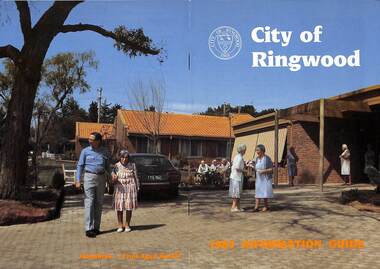
Booklet, City of Ringwood 1985 Information Guide, 1985
Community information booklet issued by City of Ringwood for 1985 - covering the facilities and activities of the Ringwood Council and other local organisations and associations. Cover photograph: Lionsbrae - Frail Aged Hostel.CONTENTS: (page no.) By-Laws/Traffic Regs. 35 Chief Executive 10 Children's Service 12, 13 & 40 Churches 41 City Map 32 & 33 Committees of Council 7 Community Services 38 Community Services Officer 43 Council Finances 24 Councillors 4 & 5 Council Meeting Dates 6 Council Representatives 8 Cultural Centre 23 Disabled Persons Facilities 44 Eastern Corridor 18 East Ringwood Shopping Centre 22 Emergency Telephone Nos. 63 Garbage Collection 20 Golf Course 15 Health 26 Historical Research Croup 47 Home Help 30 Hospitals 48 Immunisations 27 Incinerators 21 Infant Welfare Centres49 J.P.'s and Commissioners 37 Library 28 & 29 Lionsbrae 17 Management Executive 11 Mayoral Message – Cr. R. Gardini, J.P. 3 Meals on Wheels 34 North Ringwood Senior Citizens 16 Opportunity Shops 53 Parks and Reserves 53 Parliamentary Representatives 9 Playgroups 55 Pre-schools 56 Public Toilets 56 Rates 25 Ringwood Croydon Advisory Service 37 Schools 58 Senior Citizens Centres 60 Swimming Pool 14 Unemployment 62 Victoria's 150th Anniversary 36 Works Programme 18 & 19 Youth Outreach Worker 62 rinx -
 Ringwood and District Historical Society
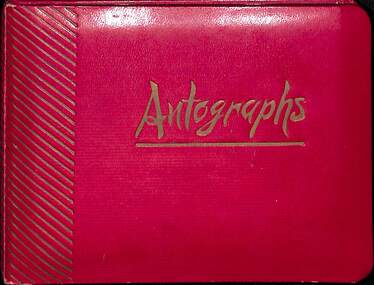
Packet, Gwen Reed nee Woodford family memorabilia c.1880s-c.1980s, Circa 1880s to c1980s
Collection of various family and personal documents, photographs, and early 1900s greeting cards. Papers of Gwen Reed from Edith Graham of Ware Cres, Ringwood East. (Provided by Nicki Shea, Granddaughter of Stan & Jo Bridgman of Eastwood Cycles) Contents: Hand-written notes – Woodford Family Tree, by Gwen Reed Autograph book with entries "To Gwen" Bookmark - with name "Lorrie B" Christmas card to May with love from George 1906 Christmas card from May to George 1906 Christmas card from Edie to Gwen (Cousin Ede) Christmas card from Dot to Gwen 1925 (from Dot Grundy, dc'd) Christmas card from Ollie S to Gwen 1924 Happy New Year card to Gwen from Grandma (Woodford) Christmas card from Mum & Ethel to Gwen 1926 Christmas card to Gwen from Emily (Gawith, Jeparit East) Christmas card from Olive to Gwen 1919 (Olive Janetski, Jeparit East) Christmas card from Hilda (Obst) to Gwen 1929 Postcard to Miss G Woodford "Bygalorie Park" Tullibigeal PO NSW (To Gwen from Effie - Effie Robson, Jeparit East) Christmas card to Gwennie from C. S. Graham 1915 (School teacher) Christmas card from Mum to May & George Christmas postcard from Grandfather to Gwenny Christmas card to Dear Daddie from Gwen Christmas card from May with love to George Christmas card from Nellie Parker (Nell Rodgers - Albury) to Gwen 1924 Greeting card from Hilda to Gwen 1919 (Hilda Obst Jeparit East) Christmas card from Ethel to Gwen 1927 Christmas card from Anne (MCGrath) to Gwen Christmas card from S. Hoober(?) (School teacher, Bygalorie) to Mr & Mrs Woodford, Gwen & Ollie) 1924 Christmas card from May and George to Mum and Dad 1925 Christmas card to Gwen Syd & Family from May Dad & Kiddies (Stepmother) Christmas card from George to May 1907 Postcard (signed Dulcie) to Mrs G. Reed, 9 Laurence Grove, East Ringwood Vic 3055 postmarked 1993 Envelope (only) addressed to Mrs. G. Reed, 9 Laurence Grove, Ringwood East Vic. 3135 Birth Certificate District of Balmoral, Victoria – Sonia Woodford b.1856 (Issued 1987) Death Certificate District of Stawell, Vic – Archibald Brown d.1914 Marriage Certificate District of Hamilton, Vic – John Brown & Margaret Dale m.1895 Coroner’s Post-Mortem report – Edward John Reed d.1981 Family Data Tree (Family Tree) William Walker/Elizabeth Silk, Hamilton Vic & children b.1842-1862 Newspaper clipping – May & Archibald Brown drowned at North Hamilton, 1887 Pictorial Souvenir – Selected Views of Mount Gambier to Miss L. Boyce, postmarked 1959 Hand-written poems/song lyrics by Gwen Reed (4 pages) Newspaper extract - Weekly Times Magazine Section “At Hamilton”, 1937 Photograph – “My mother standing with Foster parents” Photograph of Gracie (?) Grandma (?) Murray (?) Photograph of costumed performers Photograph of child Photograph of lady at John Mansell dispensary (Chemist at Forest Hill Vic?) Postcard photograph – Gwen & Ethel Woodford Photograph of grave – Victoria May Woodford (died 1957 aged 56 years) Photograph of grave – William Woodford and Sarah Woodford Photograph of un-named male Photograph of baby on chair Photograph – “Myself. Hope you like it May" Photograph (colour) – un-named group on train at Currumbin Qld Photograph – 2 un-named girls Autographs include Arthur Young Rosie Sturgess Joff Ellen Carlu Carter Toni Lamond Dick Curtis Billy Daniels Margaret Whiting Horrie Dargie Duo Moreno Therese Talbert Richard Gray Three Apollos Robert Leeman -
 Bendigo Military Museum
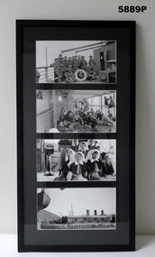
Photograph - PHOTOGRAPHS, GRINTON COLLECTION, FRAMED, 2008 - 2009
Frame 10. Photo 1. A group of Sergeants on the deck of the Karmala. Jack and Bert were the only Sergeants from the 45th quota from the original Battalion on the Karmala. There were two other Sergeants who had transferred to the 38th, one in Oct 1918, Sgt R. L. Glover from the 37th Batt and Sgt F. Perkins also from the 37th who transferred in April 1919. Both are or should be in the collection of photos. Photo 2. life on deck of the Karmalal. Photo 3. A group of nurses on the Karmala. In the family collection there are two faded sepia photos showing the others not in this negative. The negatives to these are missing. From the War Diary of the Karmala there were ten nurses on the Karmala and there are ten nurses in the photos. There was also the ship's Medical Officer who is hidden in this negative. The ship's S.M.O. was Captain C. P. Rosenthal from the 33rd Batt HQ. The nurses on board were: Sister Sarah Eliza Faulkner (Sydney) S/Nurse Ivy Louisa Robbins (Epping NSW) S/Nurse Edith Agnes Purdon (Bathurst, NSW) Sister Catherine Douglas Graham (Footscray, Vic) Nurse Gladys Webster Jarrett "RRC" (Middle Park, Vic) Nurse Ida Mary Mason (Wodonga, Vic) Nurse Ethel May Mead "RRC" (Elsternwick, Vic) Sister Elizabeth Hamilton O'Reilly (Leitchville, Vic) S/Nurse Janet Hay (Adelaide, SA) Sister Janet Ivy Barron (Ennogerra, Qld) Photo 4. Arriving at Cape Town, South Africa on the way home. Refer Cat No. 5880P for exhibition details. Refer Cat No. 1280 for Jack GRINTON Service Records.Photographs - black and white on paper. 4 photographs top to bottom. 1. Group of soldiers on ship's deck. 2. Crowd of soldiers on ship's deck. 3. Group of nurses on ship's deck. 4. View of a dock. Frame - timber with black colour paint. Glass front. Mount - black colour cardboard. Backing cardboard with handwritten notation.Backing cardboard - handwritten black felt tip pen "10."framed photographs, grinton collection, ww1, 38th -
 Bendigo Military Museum
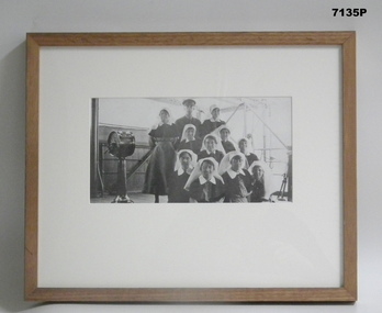
Photograph - PHOTOGRAPH, FRAMED WW1, Wayne Eels, C.2008/2009
The Grinton Collection. Ships SMO and Nurses on the HMAT Karmala on the way home 1919. SMO Capt. C. P. Rosenthal. (Ships Medical Officer) Nurses include; Sister Sarah Eliza Faulkner (Sydney) S/Nurse Ivy Louisa Robbins (Epping, NSW) S/Nurse Edith Agnes Purdon (Bathurst, NSW) Sister Catherine Douglas Graham (Footscray) Nurse Gladys Webster Jarrett RRC (Middle Park) Nurse Ida Mary Mason (Wodonga) Nurse Ethel May Mead RRC (Elsternwick) Sister Elizabeth Hamilton O'Reilly (Leitchville) S/Nurse Janet Hay (Adelaide) Sister Janet Ivy Barron (Enogerra, Qld). Refer Cat No 1280 for Jack Grintons service details.Photograph framed. Photograph - black and white photograph on paper depicting a group of nurses and a medical officer, all in uniform, in an informal group portrait. Background - ship's superstructure. Frame - Timber, light varnish finish, Perspex front, cardboard backing."Group 5: Quota 45 - Journey Home". "J. Australian nurses and a Medical Officer". framed accesssories, camera on the somme, ww1, 38th bn, grinton, hmat karmala -
 Kiewa Valley Historical Society
Papers - Collection of newspaper articles re Kiewa Valley, 1970's
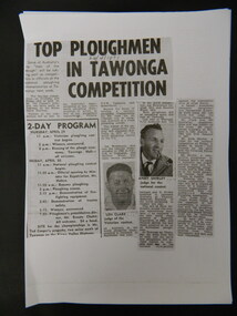
Newspaper articles describing incidents/news of the Kiewa Valley during the 1970's.Each article is significant because it is connected to people and places in the Kiewa Valley.9 photocopies of newspaper articles: 1. Fire at Mt Beauty Workmen's club 2. Ploughing Championship at Tawonga 24 Apr. 1971 3 & 4. Charles Derrick's 10 year anniversary of his death on Mt Hotham 5 Sept. 1975 5. Alps to be a National Park 15 July 1978 6. Tawonga Exchange to go Automatic 20 June 1974 7 & 8. Winter Playground 9. Alps National Parknewspaper articles; kiewa valley; news of the 1970s; -
 Kiewa Valley Historical Society
Photograph of local residents at Tawonga Caravan Park Museum Building, 11th February, 1979
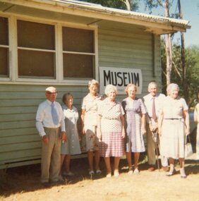
... Valley in the late 1970's Tawonga Caravan park KVHS members Kiewa ...Pictorial record of residents of the Kiewa Valley in the late 1970's and early buildings Pictorial record of residents of the Kiewa Valley in the late 1970's Colour photograph of local residents standing outside the Museum building at Tawonga Caravan ParkHandwritten on back of photograph in blue ink: Q Baldwin, C Joung, Gwen Hobbs, Mrs Van De Wyde, T & M Wallace and Mrs Temple. Taken by C Roper on 11th February, 1979tawonga caravan park, kvhs members, kiewa valley -
 Kiewa Valley Historical Society
Poster - Framed - Kergunyah
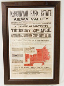
in 1922 Kergunyah Park homestead was built by David Wallace in the late 1800's and remained in the family until the sale in 1922 when it was bought by John Woodside (grandfather of Ewen Wallace) whose family retained it until 1938. Another family named Wallace bought the property in 1938 and this family's descendants are still running it in 2005.David and Henrietta Wallace purchased the original holding and built Kergunyah Park homestead in the late 1800's running cattle on the property. They arrived in Australia in 1867 with their 3 children and were early settlers in the district. Their descendants still live in the district. Their family demonstrates how properties were passed on to the next generation. The poster is an example of the advertising of the sale of land in 1922, the size of land & blocks and the conditions of sale at the time.Large cloth map mounted under glass with a brown wooden frame. Brown writing detailing Kergunyah Park 1923 Sale Record. Includes 4 rectangular brown and white photos and a red map showing 13 blocks of land. Has hanging wire attached on the back."Framed by / Clarkson Collection / Ph; 02 6059 6800"kergunyah. kiewa valley. kergunyah park homestead. ewen wallace. john woodside. -
 Kiewa Valley Historical Society
Photo - Tawonga Store
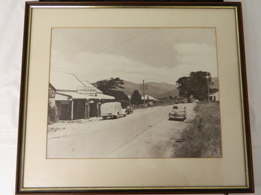
This photo was taken in the 1950's when Pearce Bros. owned the Tawonga Store. I.R.Northey's van is parked outside the store. Kodak photos are advertised. The Bakery existed. The road is sealed and telephone and electric wires are shown. The Pearce Bros owned the Tawonga Store in the 1950s when the population of the area in the Upper Kiewa Valley and High Plains was high due to the construction of the Kiewa Hydro Electric Scheme by the State Electricity Commission of Victoria.Sepia photo of Pearce Bros. Tawonga Store including a house next door, cars in the sealed street and part of the Bakery opposite. It has a slim wooden frame & white cardboard border. It has a clear glass cover. The back is lined with brown paper with a white cord across for hanging the photo.tawonga store. pearce bros. tawonga bakery. i.r.northey. -
 Kiewa Valley Historical Society
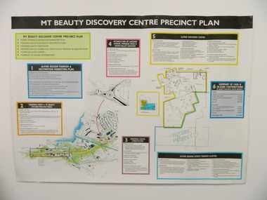
Poster - Mt Beauty Discovery Centre Precinct Plan
The current (2015) Mt Beauty Tourist Centre site was to be upgraded into a 'Sports Tourism Cluster' with funding from the Government and the Alpine Shire with 'In Kind' assistance from Falls Creek Resort management Board, Parks Victoria and the Local Community & Tourism Industry. This project didn't go ahead.The Mt Beauty town was handed over to the Alpine Shire in the 1960's after completion of the Kiewa Hydro Electric Scheme. Plans for up dating facilities are on-going but are rarely completed. This poster is an example of this.Very large laminated poster depicting 6 points for the Alpine Region Sports Tourism Cluster. Each point has a coloured border and background to black writing. There are 3 maps.mt beauty. tourism. discovery centre. sports cluster. -
 Kiewa Valley Historical Society
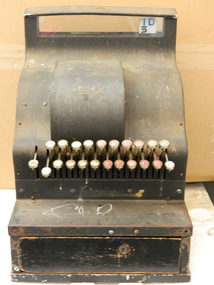
Cash Register, 1905-1906
Cash registers were used by businesses to store the money received for the transactions of goods and for recording the amount of money taken over a period of time e.g.. a day. This cash register is pre 1966, pre decimal currency and includes the halfpenny.Dudley Pigram who managed the Mongan's Bridge Caravan Park used this register. He brought it down to the Mt Bogong Clay Target Club in the 1970's although it is pre decimal currency. Dudley wass a founding member of the Clay Target Club.This brass cash register has a serial number indicating that it was made between 1905 and 1906. It is very heavy. A black metal cash register with glass across the top where the amount of the sale is displayed. There are 2 rows of keys - the top row left to right - 8/-, 6/-, 4/- 2/- with white background, 11d, 9d, 7d, 5d, 3d, 1d with red background. Bottom row left to right - 9/-, 7/- 5/- 3/- 1/- with white background, 10d, 8d, 6d, 4d, 2d, with red background plus a digital half d with a white background. Between the rows on the left is a 'No Sale' key. At the front of the register is a locked tray.Serial number S 33148. B.214KAA on a gold plaque below the glass display in the middle. On its right is a key hole. 'National' - above the keys. cash register. mongan's bridge caravan park. mt bogong clay target club. dudley pigram. business. -
 Warrnambool and District Historical Society Inc.
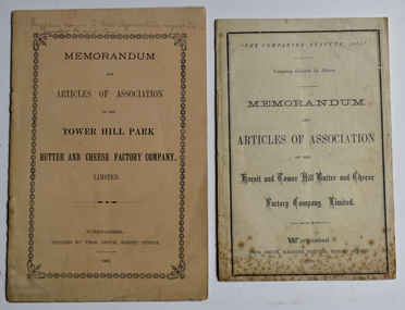
Booklet - Memorandum and Articles of Association 003048.1 Tower Hill Park Butter and Cheese Factory Company Ltd; 003048.2 Koroit and Tower Hill Butter and Cheese Factory Company Ltd, Thomas Smith Printer, 003048.1 1893; 003048.2 1888
These booklets document the formation and the aims of two early dairy factories in the Koroit and Tower Hill area. These factories later became part of the Koroit FactoryThese two memorandums of association document the formation of two early butter and cheese factories in the Koroit and Tower Hill area, listing the first directors. A meeting at the Koroit Town Hall on May 23, 1888, unanimously decided to form the Koroit and Tower Hill Butter Factory coy. Ltd. Mr W J Anderson started the movement to establish a butter factory to suit the convenience of the share farmers of the Tower Hill Park estate in the early 1890's. Both of these factories were ultimately bought out by the Koroit Factory.003048.1 10 page small buff coloured booklet dated 1893 with pencilled note "Supplier names to Dept. Agriculture requesting Pamphlets be sent them" 003048.2 8 page cream coloured booklet dated 1888003048.1 Memorandum and Articles of Association of the Tower Hill Park Butter and Cheese Factory company, Limited. Warrnambool Printed by Thos. Smith, Koroit Street. 1893 003048.2 "The Companies' Statute, 1864" company limited by Shares Memorandum and Articles of Association of the Koroit and Tower Hill Butter and Cheese Factory, Limited. ~ Warrnambool: Thos. Smith, Machine Printer, Koroit Street, 1888memorandum and articles of association, butter and cheese factory, tower hill park butter and cheese factory, koroit and tower hill butter and cheese factory, thomas smith printer, dairying factory, john wilson anderson, john campbell jnr., joseph lamb wall, thomas gleeson, john quirk, michael hally, robert kerr, william crowe, james young, patrick mcgrath, richard skilbeck, peter mcvicar, tower hill park, illowa -
 Warrnambool and District Historical Society Inc.
Document (Sketch Plan of Dunmore), Stan Baulch, 1972
This card has a sketch map showing the properties surrounding Dunmore on one side and a detailed sketch plan of Dunmore homestead in the early 1970s on the other side. The plan of Dunmore homestead shows interesting features such as the brick oven for bread making, the croquet lawn, the site of the aboriginal mia mias, the Turkish baths and the fowl house used later as a poison house. Francis and Ann Baulch were pioneer settlers in the Kirkstall area and their son Samuel worked at Dunmore in the Macarthur area before purchasing in the early 1870s the property he named Rose Park. In the 1890s he acquired property in the Dunmore estate and his son Stan Baulch gained a section of the Dunmore property after his father’s death. Stan Baulch named this Dunmore section, Rose Park, a property to the west of his father’s original Rose Park property. Stan Baulch was a long time member of the Warrnambool & District Historical Society and he contributed many local history articles and donated many local artefacts to the Society.This sketch plan is of interest as it tells us what the historic homestead of Dunmore in Western Victoria was like in the early 1970s. It will be useful for research. This is a sheet of white lightweight cardboard with a pencilled sketch on one side and a blue ink sketch plan of a house on the other side. The edges of the card have some torn sections. The card is enclosed in an oval cardboard cylinder (recycled and torn at the ends). Both the card and the cover have handwritten titles in ink. Dunmore Homestead & History by S. Baulch Dunmore Homestead drawn by Stan Baulch c.1972 dunmore property, western victoria, baulch family -
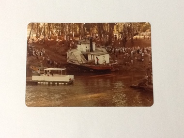 Port of Echuca
Colour Photograph, 04/03/1983
Colour photograph of P. S. Adelaide being encouraged down the soil ramp at Paddlewheel Park, onto the Murray river at Echuca. An outboard float is on the left with some spectators on it. Spectators line both sides of the ramp. Some kind of winching float is on the right. Part of photo sequence no. P000041; P000045; P000046; P000047; P000048.The re-floating of the P. S. Adelaide was a significant community social event evident by the number of spectators in the photograph. The community had invested a great deal of time and money into re-floating the paddlesteamer. The newspaper covered the event in detail with a number of action shots as the boat made its rear entry onto the Murray river.Colour photograph of P. S. Adelaide being encouraged down a soil ramp onto the river. An outboard float is on its left. Spectators line both sides of the ramp. Some kind of winching float is on the right.p. s. adelaide, echuca, re-floating p. s. adelaide -
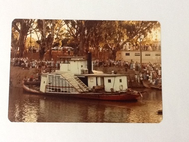 Port of Echuca
Colour Photograph, 04/03/1983
Colour photograph of the P. S. Adelaide in the river, with the port side of the boat clearly visible. The bank behind and the roof of the boat shed at Paddlewheel park are lined with spectators. Final part of the photo sequence of the event no.:P000041; P000045; P000046; P000047; P000048 of the P. S. Adelaide re-floating.The re-floating of the P. S. Adelaide was a Significant community social event evident by the number of spectators in the photograph. The community had invested a great deal of time and money into re-floating the paddlesteamer. The newspaper covered the event in detail with a number of action shots as the boat made its rear entry from the temporary slipway onto the river. Part of a photo sequence no.P000041; P000045; P000046; P000047; P000048 of P. S. Adelaide re-floating.Colour photograph of P. S. Adelaide on the Murray river at Echuca after her re-floating. The port side of the Adelaide is clearly visible. The banks of the river are lined with spectators. The pontoon boat shed at Paddlewheel Park is visible on the right, also has spectators on the roof platform.p. s. adelaide, re-floating p. s. adelaide, echuca -
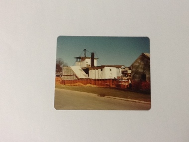 Port of Echuca
Colour Photograph, Aug 1980
The P. S. Adelaide was positioned in the Hopwood Gardens, Echuca as a static display whilst it was waiting to be fully repairedColour photograph of back port side of the P. S. Adelaide being restored on the western side of the Hopwood Garedens, Echuca, with orange fence around it and the side of a green wooden building at its right. The park sound shell is partially visible behind the boat to the right.On reserve in pen : Adelaide in Hopwood Gardens. In red pink : Print made by Kodak M. It's Kodak for color. Aug.80. Kodakp. s. adelaide, hopwood gardens, echuca, p. s. adelaide restoration -
 Port of Echuca
Black and white photograph, approx 1980
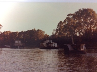
Black and white photograph of 2 steamers moored by the river bank. The foreground steamer has 2 crew dressed in sailors uniform (band members?) There is a person standing on the lower roof section putting a case (?) into the upper floor with quite a few people up there also. There appears to be musical instruments behind the crowd. On the gangplank 2 men are wheeling a piece of equipment onto the steamer. The background steamer is the P. S. Canberra, also moored to the bank and unloading. There is a row boat in the middle of the river with 4 rowers and a standing cox.This appears to be a navel band getting ready for a cruise on the river, a social event that often happens in the Echuca area. On the other side of the river can be seen a "Caltex" sign and a couple of caravans parked between the trees. This could have been part of a river festival.Black and white photograph of 2 steamers moored by the river bank. The background steamer is the P. S. Canberra. The foreground steamer has crew dressed in sailors' uniforms (band members?). There is a person standing on the lower roof section putting a case (?) into the upper floor with quite a few people up there also. There appears to be musical instruments behind the crowd. On the gangplank 2 men are wheeling a piece of equipment onto the steamer. There is a row boat in the middle of the river with 4 rowers and a standing cox.The steamer in the background is marked "Canberra". In pencil on the back is marked P000102.paddle steamers, p.s.canberra -
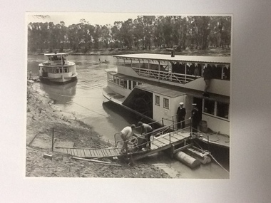
 Port of Echuca
Colour negative, coloured photograph and coloured enlargement, 03/04/1984
These photographs and negative show the P. S. Adelaide travelling from Paddlewheel Park up to the Echcua wharf, immediately after being re-launched into the Murray River on 03/04/1984. The P.S.Adelaide had been displayed in the Hopwood Gardens, as a static display since 1960. The P.S Adelaide is the second oldest wooden hulled paddle steamer, still operative, in the world. The P.S Pevensey is leading the way up to the wharf, and an unknown smaller paddle steamer follows behind. This photograph is significant because it shows the P.S Adelaide back in the Murray River after 24 years as a static display in the Hopwood Gardens. The P.S Adelaide is the second oldest wooden hulled paddle steamer, still operative in the world. In July 2016 it celebrated its 150th birthday. These images relate to P000059.3, P000060.3, P000061.3, P000062.2, P000063.3, P000070.2, P000071.Colour negative and two different sized photographs showing three paddle steamers travelling upstream towards the Echcua Wharf. There is a small unidentifiable paddle steamer in the foreground. The P.S Adelaide is sailing between the other two paddle steamers. The P.S Pevensey is in the background. The P.S Murray Queen is in the foreground. All three boats are heading towards the wharf, immediately after the re-launch of the P.S Adelaide from the Hopwood Gardens, back into the Murray River on 03/04/1984.p.s pevensey, p.s adelaide, p.s philadelphia, echcua wharf, p.s murray queen -
 Port of Echuca
Black and white photograph, 1980? A note has been added by C.J (Claire Jackson) saying that the photo was taken about 1973-74
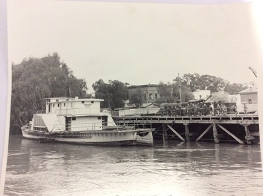
The photograph shows the state of the Echuca wharf in 1973 or 1974. The P.S Pevensey looks like it has just received a fresh coat of paint. There is also a train parked on the wharf behind the school students. The river also appears to be quite high. This photograph shows the state of the wharf in the early 1970's. It shows the fence between the wharf and Murray Esplande was relatively new. The tourism industry was very new to Echuca in the 1970's but the P.S Pevensey looks ready to take Tourists cruising on the Murray River. It also shows schools were using the port as a valuable resource for teaching History.A black and white photograph of the P.S Pevensey tied up to the Echuca Wharf. There is a group of school children leaning over the wire fence at the edge of the wharf. There is also one teacher supervising the children. The Steam Packet Inn and the Customs House can be seen in the background.Pevensey; Melbourne can be seen clearly written on the paddle steamer. On the back of the photograph is written "This photograph is with the compliments of the Ministry of Tourism, Government of Victoria. Please acknowledge photo; Michael Cheshire. There is also a purple Port of Echuca stamp on the back of the photograph.echuca wharf, p. s pevensey, ministry of tourism, cheshire, michael -
 Port of Echuca
A rectangular coloured photograph, 1979
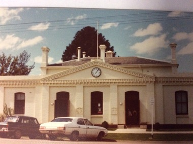
This is a picture of the original Town Hall building built in High Street in the 1890's. It was designed by renowned Bendigo Architect W.C .Vahland. This picture was taken in 1979 when the Echuca Library was housed there. The Echuca Library operated out of this building from 1965 up to 2013 when the new library was built. In this photograph there are two people standing in the doorway and two cars parked in the street.This photograph is significant because it shows the first Town Hall building built in High Street in the late 1890's. The building was designed by W.C Vahland and was also used as the Law Courts before the Law Court building was built in Law Court Place. This building has also been used as the High School, while the Echuca High School was being built in the 1920's it was also used as a Kindergarten and the town Library operated there from 1965 to 2012 when the new Library was built. The Shire of Campaspe Information Technology Department has been housed there from 2012 up to the Present.A coloured photograph, in postcard size, of the original Town Hall building of Echuca, taken in 1979, when the building was being used as the Echuca Library.echuca town hall, echuca library, vahland, w.c -
 Port of Echuca
Photograph - Coloured photograph, March 1984
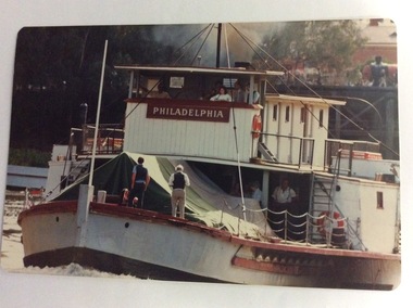
This photograph was taken in February 1984 on the occasion of Cossen's visit to Echuca. It is a close up of the wheelhouse of the P.S Pevensey with the name Philadelphia written across the wheelhouse. This is significant because the P.S Pevensey played the role of the P. S Philadelphia in the movie "All The Rivers Run" which was filmed in Echuca in late 1982 and a sequel was filmed in Echuca early in 1989.This photograph is significant because it shows the P.S. Pevensey showing the name P.S Philadelphia. The P.S Pevensey was used as the P.S Philadelphia in the TV Series "All The Rivers Run" based on the novel written by Nancy Cato. The TV series was a huge success and still draws tourists to the Port of Echuca. The fact that the P.S Pevensey was showing the Philadelphia name in 1984 is a bit of a mystery, but it has been known that she was dressed up again as the P.S Philadelphia sometimes for special occasions. The Cossen's visit to Echuca might have been such an occasion. It also shows the Echuca Wharf with a train parked there, and the Customs House can be seen in the background as well.A close-up image of the P.S. Pevensey travelling upstream away from the Echuca Wharf. There are five people in the wheelhouse; a dark haired young woman and a man in a suit and tie, two crew and there are two men standing with their backs to the photographer, on the lower deck. Three people can be seen near the fire box underneath the wheelhouse. The Echuca Wharf can be seen in the background. p.s pevensey, greenspot photography, murray river, echuca, la grue, bill, cossen's visit to echuca., all the rivers run, p. s philadelphia, cossen family, echuca wharf -
 Eltham District Historical Society Inc
Photograph - Aerial Photograph, Landata, Montmorency, Feb. 1956
Centred on present day Tahlee Place Reserve and Sherbourne Preschool, Montmorency bounded by Progress Road to north, Withers Way to south, Main Road to east and Leach Street to west. Historic Aerial Imagery Source: Landata.vic.gov.au Aerial Photo Details: Project No :250 Project : MELBOURNE OUTER SUBURBS PROJECT Run : 17 Frame : 114 Date : 02/1956 Film Type : B/W Camera : EAG9 Flying Height : 10000 Scale : 12000 Film Number : 1176 GDA2020 : 37°42'50"S, 145°08'02"E MGA2020 : 335512, 5824286 (55) Melways : 21 F5 (ed. 42)aerial photo, 1956-02, neil webster collection, central park, eltham, leach street, main road, melway 21f5, montmorency, progress road, withers way, sherbourne preschool, tahlee place reserve -
 Eltham District Historical Society Inc
Photograph - Aerial Photograph, Landata, Montmorency, Feb. 1956
Centred on present day Grand Boulevard and Olympic Way, Montmorency bounded by Diamond Street to north, Old Eltham Road and Eltham Lower Park to south, Bible Street to east and Para Road to west. Historic Aerial Imagery Source: Landata.vic.gov.au Aerial Photo Details: Project No :250 Project : MELBOURNE OUTER SUBURBS PROJECT Run : 17 Frame : 115 Date : 02/1956 Film Type : B/W Camera : EAG9 Flying Height : 10000 Scale : 12000 Film Number : 1176 GDA2020 : 37°43'24"S, 145°07'55"E MGA2020 : 335375, 5823236 (55) Melways : 21 F7 (ed. 42)aerial photo, 1956-02, neil webster collection, eltham, main road, montmorency, bible street, diamond street, eltham lower park, grand boulevard, melway 21f7, old eltham road, olympic way, para road -
 Eltham District Historical Society Inc
Photograph - Aerial Photograph, Landata, Eltham, Feb. 1956
Centred on present day Culla Hill and Petty's Orchard, Eltham bounded by Brougham Street and Mount Pleasant Road to north, Monckton Road, Templestowe to south, Reynolds Road to east and Eltham Lower Park and Hohnes Road to west. Historic Aerial Imagery Source: Landata.vic.gov.au Aerial Photo Details: Project No :250 Project : MELBOURNE OUTER SUBURBS PROJECT Run : 18 Frame : 92 Date : 02/1956 Film Type : B/W Camera : EAG9 Flying Height : 10000 Scale : 12000 Film Number : 1176 GDA2020 : 37°43'35"S, 145°09'31"E MGA2020 : 337735, 5822959 (55) Melways : 22 B8 (ed. 42)aerial photo, 1956-02, neil webster collection, eltham, brougham steet, culla hill, eltham lower park, hohnes road, melway 22b8, monckton road, mount pleasant road, petty's orchard, reynolds road, sweeneys lane, templestowe, yarra river -
 Eltham District Historical Society Inc
Photograph - Aerial Photograph, Landata, Eltham, Feb. 1956
Centred on present day Mount Plaeasant Road near Dalton Street, Eltham bounded by Luck Street to north, Eltham Lower Park to south, Reynolds Road to east and Central Park to west Historic Aerial Imagery Source: Landata.vic.gov.au Aerial Photo Details: Project No :250 Project : MELBOURNE OUTER SUBURBS PROJECT Run : 18 Frame : 93 Date : 02/1956 Film Type : B/W Camera : EAG9 Flying Height : 10000 Scale : 12000 Film Number : 1176 GDA2020 : 37°43'02"S, 145°09'38"E MGA2020 : 337871, 5823961 (55) Melways : 22 B6 (ed. 42)aerial photo, 1956-02, neil webster collection, eltham, central park, eltham lower park, luck street, melway 22b6, nyora road, reynolds road, dalton street, mount pleasant road -
 Eltham District Historical Society Inc
Photograph - Aerial Photograph, Landata, Eltham, Vic, Apr. 1963
Centred on present day Zig Zag Road and Main Road, Eltham bounded by Maroondah Aqueduct to north, Thompson Crescent and Arthur Street to south, Parsons Road to east and Glen Park Road and Banks Road to west. Historic Aerial Imagery Source: Landata.vic.gov.au Aerial Photo Details: Project No :486 Project : MELBOURNE (1963) PROJECT Run : 5 Frame : 59 Date : 04/1963 Film Type : B/W Camera : RC8 Flying Height : 5100 Scale : 9600 Film Number : 1805 GDA2020 : 37°42'24"S, 145°08'52"E MGA2020 : 336716, 5825114 (55) Melways : 21 J3 (ed. 42)aerial photo, neil webster collection, eltham, 1963-04, arthur street, banks road, glen park road, maroondah aqueduct, melway 21j3, parsons road -
 Eltham District Historical Society Inc
Photograph - Aerial Photograph, Landata, Eltham, Vic, Apr. 1963
Centred on present day Floriston Grove, Eltham bounded by Maroondah Aqueduct to north, Thompson Crescent and Diosma Road to south, Research Shops to east and Glen Park Road and Park West Road to west. Historic Aerial Imagery Source: Landata.vic.gov.au Aerial Photo Details: Project No :486 Project : MELBOURNE (1963) PROJECT Run : 5 Frame : 60 Date : 04/1963 Film Type : B/W Camera : RC8 Flying Height : 5100 Scale : 9600 Film Number : 1805 GDA2020 : 37°42'24"S, 145°09'29"E MGA2020 : 337622, 5825128 (55) Melways : 22 B3 (ed. 42)aerial photo, neil webster collection, eltham, 1963-04, diosma road, floriston grove, maroondah aqueduct, melway 22b3, park west road, research (vic.), research shops -
 Eltham District Historical Society Inc
Photograph - Aerial Photograph, Landata, Eltham, Vic, Apr. 1963
Centred on present day Eltham Lower Park bounded by Brougham Street to north, Yarra River and Fitzsimons Lane Bridge to south, Main Road at Kent Hughes Road to east and Bolton Street to west. Historic Aerial Imagery Source: Landata.vic.gov.au Aerial Photo Details: Project No :486 Project : MELBOURNE (1963) PROJECT Run : 7 Frame : 232 Date : 04/1963 Film Type : B/W Camera : RC8 Flying Height : 5100 Scale : 9600 Film Number : 1805 GDA2020 : 37°44'03"S, 145°08'33"E MGA2020 : 336329, 5822040 (55) Melways : 21 H10 (ed. 42)aerial photo, neil webster collection, 1963-04, bolton steet, brougham steet, eltham, eltham lower park, fitzsimons lane bridge, kent hughes road, melway 21h10, yarra river -
 Eltham District Historical Society Inc
Photograph - Aerial Photograph, Landata, Eltham, Vic, Apr. 1963
Centred on present day Griffith Park Road, Eltham bounded by Mount Pleasant Road to north, Yarra River and Templestowe to south, Main Road at Reynolds Road to east and Falkiner Street to west. Historic Aerial Imagery Source: Landata.vic.gov.au Aerial Photo Details: Project No :486 Project : MELBOURNE (1963) PROJECT Run : 7 Frame : 233 Date : 04/1963 Film Type : B/W Camera : RC8 Flying Height : 5100 Scale : 9600 Film Number : 1805 GDA2020 : 37°44'04"S, 145°09'10"E MGA2020 : 337237, 5822053 (55) Melways : 22 A10 (ed. 42)aerial photo, neil webster collection, 1963-04, eltham, falkiner street, griffith park road, melway 22a10, mount pleasant road, reynolds road, templestowe, yarra river -
 Eltham District Historical Society Inc
Photograph - Aerial Photograph, Landata, Eltham, Vic, Apr. 1972
Centred on present day Zig Zag Road near Coolabah Drive, Eltham bounded by Allendale Road to north, Park West Road to south, Parsons Road to east and Banks Road to west. Historic Aerial Imagery Source: Landata.vic.gov.au Aerial Photo Details: Project No :985 Project : MELBOURNE 1972 Run : 26 Frame : 191 Date : 04/1972 Film Type : B/W Camera : RC10 Flying Height : 5700 Scale : 9600 Film Number : 2636 GDA2020 : 37°41'56"S, 145°09'26"E MGA2020 : 337533, 5826000 (55) Melways : 22 A1 (ed. 42)aerial photo, neil webster collection, 1972-04, allendale road, eltham, eltham north, zig zag road, banks road, coolabah drive, melway 22a1, park west road, parsons road -
 Eltham District Historical Society Inc
Photograph - Aerial Photograph, Landata, Eltham, Vic, Apr. 1972
Centred on present day Woodridge Estate, Eltham bounded by Park Road to north, Mount Pleasant Road to south, Stokes Orchard Estate to east and Eltham Railway Station to west. Historic Aerial Imagery Source: Landata.vic.gov.au Aerial Photo Details: Project No :985 Project : MELBOURNE 1972 Run : 27 Frame : 46 Date : 04/1972 Film Type : B/W Camera : RC10 Flying Height : 5700 Scale : 9600 Film Number : 2636 GDA2020 : 37°42'49"S, 145°09'46"E MGA2020 : 338053, 5824365 (55) Melways : 22 C5 (ed. 42)aerial photo, neil webster collection, 1972-04, eltham, eltham railway station, melway 22c5, mount pleasant road, park road, stokes orchard estate, woodridge estate