Showing 192 items
matching property rate
-
 Glen Eira Historical Society
Article - Glenfern
Photocopy of typed research, undated, from an unknown author, regarding the architectural style of Glenfern, the changing landscaping from 1860, an addition to the property in 1876 and extracts from Jeannie Watson’s diary (daughter of then owner) dated 1870. Includes references from rate books, sale notices, titles, local history, Boyd history and various other sources. Includes photographs, poorly reproduced.glenfern, st kilda east, balaclava station, boyd captain, inkerman road, inkerman street, balaclava, mcdonnell francis, laing charles, architects, architectural features, boyd john t. t., gothic revival, hotham street, watson jeannie, coldham edith lucy, swanson donald, à beckett minnie, ostberg sarah ann -
Glen Eira Historical Society
Document - Cambria
This folder contains one document about the owners of this property: The page provides a list of the tenants of Cambria, Neerim Road from 1891 to 1940. Sourced from Sands and McDougall. Also, Caulfield Rate Book Listings for the period 1889 to 1897. The document also provides a brief biography of George Davis with a reference to the Biography of Victorian Parliament. Handwritten, unattributed and undated.cambria, neerim road, davis george, davis george mrs, davies george, davis j h, deans walter , widdes john, widdes e a mrs, ellis richard, godby c t, presentation covent and ladies college, roseberry avenue, caulfield -
 Eltham District Historical Society Inc
Photograph, The Stokes family home and orchard blanketed with snow, corner Nyora and Eucalyptus roads, Eltham, Winter 1951, 1951
Taken from outside the family home on the southest corner of the intersection of Nyora Road and Pitt Street with Eucalyptus Road. Frank Stokes first traveled to the district by train in 1944 to find land with the intention to establish an orchard. By chance he met Arthur Bird of Bird Orchard (bounded by Pitt Street, Eucalyptus Road and Wattle Grove) and they got talking over their common interest. Arthur put Frank up for the night and pointed out the land, part of Crown Allotment 15, Section 5, Parish of Nillumbik (CA15) somewhat diagonally opposite Bird Orchard. Frank bought the land and for the next two years would travel by train from Melbourne to Eltham every weekend establishing Stokes Orchard and building a home for his family, which they eventually moved into in 1946. Marjorie North remembered well the winter of 1951, when she took children, including son John together with the Shallard and Squire children “in the Austin A40 up the Main Rd., Eltham to farmer Bell’s property alongside the Eltham College. They were able to make a snow man and throw snowballs. (Diamond Valley News, August 5, 1986.p.42) In the mid 1970s the Shire of Eltham divided the orchard up into numerous rate-able parcel lots, which became affordable for Frank. As a consequence Stokes Orchard was turned into a housing development by Macquarie Builders and marketed as the Stokes Orchard Estate in two stages; Stage 1 encompassing Scarlet Ash Court, Ironbark Close and Peppermint Grove bounded by Nyora and Eucalyptus roads c.1976 and Stage 2 encompassing Stokes Place, Orchard Way, The Crest and The Lookout bound by Nyora and Diosma roads c.1979. The development of Orchard Way, The Crest and The Lookout did not proceed as planned due to the lack of the sewer along Diosma Road and so many of the proposed lots were incorporated into five-acre parcels instead.Representative of the orchard growing areas of Eltham. One of the rare times it has snowed in Eltham.Digital file only - Digitised by EDHS from a scrapbook (containing commercially printed photos of digital scans) on loan from Beryl Bradbury (nee Stokes), daughter of Frank Stokes.1951, beryl bradbury (nee stokes) collection, eltham, nyora road, eucalyptus road, snow, stokes family home -
 Eltham District Historical Society Inc
Film - Video (DVD), Frank Stokes, Stokes Family, 1950-1977
Various family scenes taken from outside the family home on the southeast corner of the intersection of Nyora Road and Pitt Street with Eucalyptus Road. Also, scenes of the Stokes Orchard and equipment used, construction of water reservoir at the end of Nyora Road near Reynolds Road and Diosma Road as well as early stages of the Stokes Orchard housing development. Frank Stokes worked as a qualified accountant at Kennons leather factory in Burnley, while living at 1 Thomas Street, Mitcham. He suffered from migraines and wanted to go back to the land (he had previously worked on farms and orchards since coming to Australia in 1926 both in WA and Vic.). He first travelled to the district by train in July 1942 to find land with the intention to establish an orchard. By chance he met Arthur Bird of Bird Orchard (bounded by Pitt Street, Eucalyptus Road and Wattle Grove) and they got talking over their common interest. Arthur put Frank up for the night and pointed out the land, 158 acres- Taylor Estate- £900, part of Crown Allotment 15, Section 5, Parish of Nillumbik (CA15) somewhat diagonally opposite Bird Orchard. He applied through the Riverina Agency to purchase the land who in turn had to get permission from Canberra to sell as there was a new government regulation banning land sales except for immediate production. He obtained a loan on his Mitcham house of £600 @ 5% and paid £450 deposit with quarterly payments of £15 over 5 years. The title to the property was issued May 15, 1946. He was helped and advised by Arthur Bird who farmed the neighbouring orchard. Early 1943 he took possession and would catch the train out to Eltham on Fridays after work and began building a hut for shelter and to lock up tools. He was able to pay a neighbour (Hawkins) to help with clearing and fencing 25 acres and with a horse and single furrowed plow, planted approximately 2,500 fruit trees - cherries, peaches, plums, almonds, pears, apricots and lemons as well as a few apples and oranges; a massive job. A huge problem was hares and rabbits eating all the new buds off the tiny trees. As well as laying poison he painted the trees with a mixture of cow manure and lime. Often working by moonlight. It was extremely difficult to get wire and wire netting because of the war but after much effort he obtained a permit from the Agricultural Department for supplies in March 1944. In February 1945 he applied for a permit to build a “packing shed” as no house building allowed. It was to be 33 feet x 21 feet and cost £312. Constructed mostly from second-hand materials, which was hard to obtain, especially iron for roofing. Frank finished work at Kennons October 31, 1945, and in March 1946 he sold the Mitcham house for £1230 plus £170 for furniture. The family of five then moved into a very unfinished at Eltham, which was a struggle to weatherproof. Eventually rooms were divided off and lined with hessian bags and whitewashed. Their income was firewood (cut and sold), selling rockery stones and cut sweet bursaria. (It was discovered during the 1940s that Bursaria contained the sunscreen compound Aesculin. The RAAF utilised this compound from Bursaria during WW2 for pilots and gunners.) The orchard’s first fruit sale was a 1/2 case of Le Vanq peaches in December 1947 - 8 shillings. In 1956 plans for house were drawn and Glen Iris bricks purchased (1956 Olympic Rings variant). The building of the house commenced in 1957 - 12 feet of original packing shed removed – and was completed in 1959. Water was connected from newly built pressure storage on the property at the end of 1959 and the electricity connection for the first time at 3pm on April 29, 1960. In the mid-1970s the Shire of Eltham divided the orchard up into numerous rate-able parcel lots, which became unaffordable for Frank. Consequently, Stokes Orchard was turned into a housing development by Macquarie Builders and marketed as the Stokes Orchard Estate in two stages; Stage 1 encompassing Scarlet Ash Court, Ironbark Close and Peppermint Grove bounded by Nyora and Eucalyptus roads c.1976 and Stage 2 encompassing Stokes Place, Orchard Way, The Crest and The Lookout bound by Nyora and Diosma roads c.1979. The development of Orchard Way, The Crest and The Lookout did not proceed as planned due to the lack of the sewer along Diosma Road and so many of the proposed lots were incorporated into five-acre parcels instead. With the arrival of the sewer along Diosma Road many years later, most of these five-acre parcels have since been subdivided many times.Representative of the orchard growing areas of ElthamMP4 00:24:39; 426MB Digital file only - Digitised by EDHS from a DVD copy on loan from Beryl Bradbury (nee Stokes), daughter of Frank Stokes. 24 min duration compilation of home movie Super 8mm film shot by Frank Stokes brother-in-law.beryl bradbury (nee stokes) collection, frank stokes, nyora road, stokes orchard, stokes orchard estate, stokes place, video recording -
 Eltham District Historical Society Inc
Document - Newspaper clipping, "The lap of luxury; Blending into Eltham environ", Property Age, The Age, Wednesday 24 June 1998, p5, June 1998
Both of the architects involved in the 2.4-hectare Kinloch Gardens parkland development in Arthur Street, Eltham, are now living on the estate. The project was conceived by Eltham architect Ian Jelbart, whose family has owned the land for more than 100 years, and fellow architect Graeme Gunn, who in the 1960s was one of the creators of the Merchants Builders concept that set new trends in Melbourne housing. The $5 million project is based around two of the original buildings, on what was once a 100-hectare farm owned by the Jelbart family. Ian Jelbart always intended to continue living in the original homestead building, and now Graeme Gunn has moved into the big residence that once was the barn. Kinloch Gardens is designed to combine the more manageable land sizes increasingly demanded by buyers with ample "internal space, flexible floorplans, privacy and individuality of designs. Individual houses are placed on small separate allotments around an area of private parkland. The aim is to ensure total privacy, offer virtually unlimited views and parkland vistas, and remain aesthetically compatible with the local environment. Homes in four basic designs over either two or three levels are being sold off the plan, with prices ranging from the high $200,000s to the high $300,000s. Two have already been sold. Indication of land-only values The prices being asked for some vacant blocks offered for private sale provides an enlightening comparison of the relative "land only" values for homes sites in various areas. A 751 sq metre block on a new residential estate in Bentleigh/Carnegie is offered at $235,000, equivalent to $312/square metre; while in Merrett Drive, Williamstown, a 561 sq metre allotment offered for $169,000 carries a rate of $301/sq metre. In Barnsbury Road, Balwyn, the $450,000 price tag on a 584 sq metre allotment equates to $770 sq metre; and in York Street, Richmond, a 198 sq metre postage stamp is priced at $230,000 or $1162/sq metre. - Rex BookerDigital file only; created from scan undertaken by EDHS of item on loanarthur street, eltham, graeme gunn, houses, ian jelbart, jelbart property, kinloch gardens, rob maclellan, robert marshall, woodridge estate -
 Eltham District Historical Society Inc
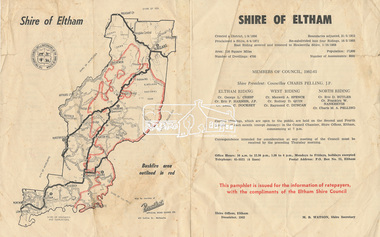
Pamphlet, Shire of Eltham, December 1962, 1962
Ratepayer information pamphlet issued by Eltham Shire Council. Gives details on shire boundaries and bushfire area, basic history, Councillors by Riding, meetings,office hours. Also information on the 1962 bushfires that raged throughout half the shire, 14-16 January 1962; local laws regarding dogs; Rates, Works Programme, Shire Offices and Town Planning The 1962 bushfire took two lives and caused damage to property approaching £1 million. Approximately 180 habitable dwellings were destroyed, hundreds of miles of fencing were burnt and thousands of acres of pasture lost.Colour bifold printed double sided (4 pages) councillors, dogs, eltham shire council, eltham shire office, infrastructure, rates, ridings, shire boundaries, shire of eltham, town planning, victorian bushfires - 1962, works programme -
 Bendigo Military Museum
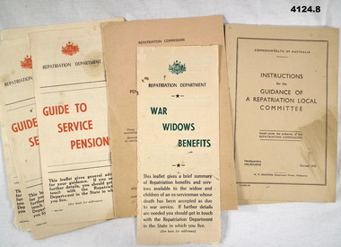
Flyer - BOOKLETS, DOCUMENTS, REPATRIATION, Commonwealth of Australia, 1) October 1959, .2) November 1952, .7) & .8) 1953
... of Australia, details a a guide to Service pensions, means test, rates... of Australia, details a a guide to Service pensions, means test, rates ...The Dept of Repatriation of the Commonwealth of Australia is now The Dept of veterans Affairs..1) Document 14 pages, re repatriation benefits, pensions and Allowances from the Commonwealth of Australia Repatriation Dept. This is actually 3 documents all the same but have been glued together like a pamphlet, two on white paper, one on blue paper. .2) Document 8 pages, light brown colour, stapled from the Repatriation Commission, amendments on pensions, medical treatment and other benefits. .3) Document, folds into 3, yellowish paper printed in green and black relating to War Widows benefits from the Australian Repatriation Dept, no date but benefits are in pounds, schillings and pence, pre 1966. .4) .5) & .6) Documents, folds into 3, yellowish paper, red and black printing from the Repatriation Dept of Australia, details a a guide to Service pensions, means test, rates of pensions, property etc. .7) & .8) Booklets, 53 pages, off white colour from the Commonwealth of Australia with instructions for the guidance of a repatriation local committee, issued by the Repatriation Commission.repatriation, pensions, allowances -
 Wycheproof & District Historical Society Inc.
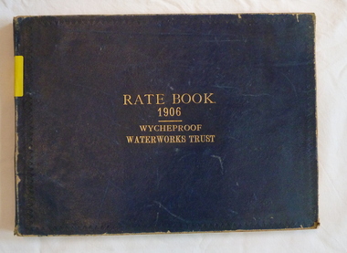
Register - Rate Book, Rate Book Wycheproof Waterworks Trust, 1906
This Register records names, locations, addresses of Ratepayers in the Rural area of Wycheproof in 1906.It is historically and socially significant at a State level as it is associated with the development of Wycheproof and District.Blue covered book with rectangular shape. Locations of Rateable Property encompasses a huge rural area. water-rates, rate-register, wycheproof - rural -
 Greensborough Historical Society
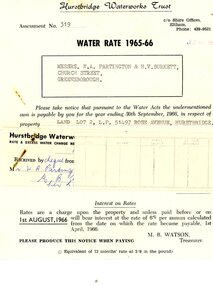
Financial record - Account, Hurstbridge Waterworks Trust, Hurstbridge Waterworks Trust water rate assessment 1965-66, 13/05/1965
Hurstbridge Waterworks Trust water rates accounts for land jointly owned by W.A. (Alan) Partington and H.V. (Horrie) Burkett for 2 properties in Hurstbridge (Rose Avenue and Daphne Crescent.Alan Partington and Horrie Burkett had a history of joint property ownership from their early days in Warragul.2 Water rates accounts, black text on white paperHandwritten receipt.alan partington, william alan partington, partington family, horrie burkett, hurstbridge, hurstbridge waterworks trust -
 Greensborough Historical Society
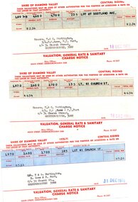
Financial record - Account, Shire of Diamond Valley, Shire of Diamond Valley rates notices 1969-1970, 26/03/1958
3 Shire of Diamond Valley Rates assessments issued jointly to Trevor and Gary Partington and their sisters, Mrs Elinor Rowe and Mrs Faye Fort. The locations of the land are Lot 41 Church Street and Lot 67 Scotland Avenue Greensborough. It is possible that this land was purchased by Alan Partington in his adult children's names.Part of the property owned by the Partington family in the original Greensborough farmland. 3 Rates notices, printed in red text with black typed details.Date stamped with rubber stampalan partington, william alan partington, partington family, land deals greensborough, church street greensborough, scotland avenue greensborough -
 Greensborough Historical Society
Financial record - Account, Shire of Diamond Valley, Shire of Diamond Valley rates notices 1970-1971, 26/03/1958
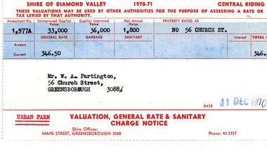
Shire of Diamond Valley Rates assessment issued to Alan Partington in 1970. This land is assessed as an "Urban Farm". In 1974 the 'farm rate' was declined for this property, eventually leading to its acquisition by the Shire for recreational space, now known as Whatmough Park.Part of the property owned by the Partington family in the original Greensborough farmland. Rates notice, printed in red text with black typed details.Date stamped with rubber stampalan partington, william alan partington, partington family, land deals greensborough, church street greensborough, whatmough park -
Glenelg Shire Council Cultural Collection
Administrative record - Rate Notice - Portland Borough Council, 1941-1942
Rate notice 1941 -42 Portland Borough Council, Portland Waterworks trust, Portland Sewerage Authority, dated 14 APR 1942, for property at 57 Percy St Portland -
 Eltham District Historical Society Inc
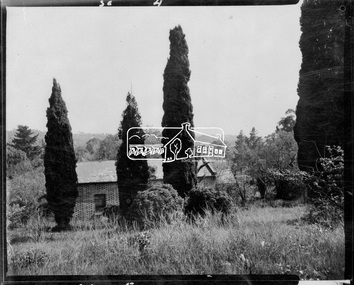
Photograph, John Collins, Shillinglaw Cottage on its original site, 17 Oct. 1963
Shilinglaw Cottage in its original location on Main Road Eltham with the “Shillllinglaw trees”. This image was taken shortly before its relocation. Believed to be have been taken by John Collins, 17 Oct 1963 as per other images held by the State Library of Victoria Author / Creator: John T Collins 1907-2001 , photographer. J.T. Collins Collection, La Trobe Picture Collection, State Library of Victoria. Shillinglaw Cottage is significant to Eltham’s local history. It is one of the earliest known buildings still in existence. Records suggest that the cottage was built circa 1859 by a man named Cochrane, believed to be Thomas Cochrane, in conjunction with George Stebbings though it is not known what Stebbings’s contribution was. It is made from hand made bricks laid in a Flemish bond pattern. In the 1960s it was marked for demolition to make way for the construction of new council buildings but a community campaign saved the cottage and it was re-located. It is believed Stebbings owned the cottage between 1874 and 1888. According to Margaret Ball’s (2017) book Shillinglaw Family of Eltham 1660-2007, Thomas Cochrane and family lived there from 1867 to 1874 however this is contrary to the records of assessable rates levied by the Eltham District Road Board, established in 1858, which shows Cochrane was the owner occupier (in Little Eltham) of approximately 25 acres of cultivated land and 25 acres of pastureland upon which a hut was sited in 1860. It is suspected that George Stebbings may have acquired the property from Cochrane in 1874 as it is noted that he had a tenant for a period, James Rossiter, who was the editor for the Evelyn Observer in Kangaroo Ground in 1874 (LATE SHIRE OFFICE AT KANGAROO GROUND (1934, February 16). Advertiser (Hurstbridge, Vic. : 1922 - 1939), p. 5. Retrieved February 25, 2022, from http://nla.gov.au/nla.news-article56743657). In 1881 Phillip Shillinglaw became the ratepayer for the cottage though Stebbings retained ownership until 1888 at which time it was transferred to Shillinglaw. This photo forms part of a collection of photographs gathered by the Shire of Eltham for their centenary project book, "Pioneers and Painters: 100 years of the Shire of Eltham" by Alan Marshall (1971). The collection of over 500 images is held in partnership between Eltham District Historical Society and Yarra Plenty Regional Library (Eltham Library) and is now formally known as 'The Shire of Eltham Pioneers Photograph Collection.' It is significant in being the first community sourced collection representing the places and people of the Shire's first one hundred years.Digital image 4 x 5 inch B&W Negsepp, shire of eltham pioneers photograph collection, eltham, shillinglaw cottage, shillinglaw trees, significant tree -
 Eltham District Historical Society Inc
Negative - Photograph, Shillinglaw Cottage, 17 Oct. 1963
Shilinglaw Cottage in its original location on Main Road Eltham with the three Mediterranean Cypress trees (“Shillllinglaw trees”) in the garden. Note a fourth pine to the right. This image was taken shortly before its relocation. Believed to be have been taken by John Collins, 17 Oct 1963 as per other images held by the State Library of Victoria Author / Creator: John T Collins 1907-2001 , photographer. J.T. Collins Collection, La Trobe Picture Collection, State Library of Victoria. Shillinglaw Cottage is significant to Eltham’s local history. It is one of the earliest known buildings still in existence. Records suggest that the cottage was built circa 1859 by a man named Cochrane, believed to be Thomas Cochrane, in conjunction with George Stebbings though it is not known what Stebbings’s contribution was. It is made from hand made bricks laid in a Flemish bond pattern. In the 1960s it was marked for demolition to make way for the construction of new council buildings but a community campaign saved the cottage and it was re-located. It is believed Stebbings owned the cottage between 1874 and 1888. According to Margaret Ball’s (2017) book Shillinglaw Family of Eltham 1660-2007, Thomas Cochrane and family lived there from 1867 to 1874 however this is contrary to the records of assessable rates levied by the Eltham District Road Board, established in 1858, which shows Cochrane was the owner occupier (in Little Eltham) of approximately 25 acres of cultivated land and 25 acres of pastureland upon which a hut was sited in 1860. It is suspected that George Stebbings may have acquired the property from Cochrane in 1874 as it is noted that he had a tenant for a period, James Rossiter, who was the editor for the Evelyn Observer in Kangaroo Ground in 1874 (LATE SHIRE OFFICE AT KANGAROO GROUND (1934, February 16). Advertiser (Hurstbridge, Vic. : 1922 - 1939), p. 5. Retrieved February 25, 2022, from http://nla.gov.au/nla.news-article56743657). In 1881 Phillip Shillinglaw became the ratepayer for the cottage though Stebbings retained ownership until 1888 at which time it was transferred to Shillinglaw.Shillinglaw Cottage is itself historically, aesthetically and socially significant to the Shire of Nillumbik and is registered on the Victorian Heritage Database. This photo forms part of a collection of photographs gathered by the Shire of Eltham for their centenary project book, "Pioneers and Painters: 100 years of the Shire of Eltham" by Alan Marshall (1971). The collection of over 500 images is held in partnership between Eltham District Historical Society and Yarra Plenty Regional Library (Eltham Library) and is now formally known as 'The Shire of Eltham Pioneers Photograph Collection.' It is significant in being the first community sourced collection representing the places and people of the Shire's first one hundred years.Digital image 4 x 5 inch B&W Negsepp, shire of eltham pioneers photograph collection, eltham, shillinglaw cottage, significant tree -
Kiewa Valley Historical Society
Polisher Floor, Hoover Appliances, Meadowbank
This appliance was a time saving method of cleaning floors. It appeared at a time (after World War II) when the domestic pressures faced by mothers and domestic staff was on the increase. The necessary "working parents" was through necessity becoming part of the "typical" family environment. It was the start of the ever increasing demand, from an economical reason, for both parents to work outside their property. Historically the period of the 1950s was one of extreme changes. It was an era where established role models were under pressure from an ever increasing demand for new and advancing consumerism. Communication levels via radio, newspapers and television was expanding at an ever increasing rate. Relatively isolated rural areas were opening up (post war) to foreign ideologies of consumerism. The basic restraints of "this will be alright mate, she'll do" was under a slow but effective take over. "I can get this done faster by this new whiz bang gadget that I saw on the TV last night!" was the new way to live by.This item is very significant in that it demonstrates the new consumerism at its infant stage of the social changes occurring due to greater communication levels between the rural Australian communities and other advancing communities world wide. The Kiewa Valley residents (mainly from the intermingling of rural and post World War II refugees working at the construction of the Victorian Hydro electricity installations, resulted in this rural area becoming integrated to new ways of living (both socially and economically). Once the attitude of "we have always done it this way mate!" was challenged and overcome, the acceptance of new time saving "gadgets" which started to pour in from foreign markets, the relative isolation of the Kiewa Valley (being mainly psychological entrenched), was over.This hoover electric floor scrubber and polisher has a main base containing two brushes (can be replaced with polishing pads). The two brushes/pads are fastened or removed from the base unit by pulling/pushing the heads from the small hexagonal shaft on the bottom of the machine motor. A pressure sensitive wire is inlaid at the brush/pad end to hold the brush/pad unit onto the shaft. The discs body and main body covering the electric motor are made from sturdy plastic. The rest of the appliance materials i.e. upright handle and the u framed attaching arm are made from lightweight powder coated steel. A small (350mm) red coloured foot switch protrudes from the back of the motor to release the the upright handle from the storage position to the action position.There are two fork shaped brackets on the rear of the handle, for securing the 6.5 metre long electrical cord and plug. There is no on/off switch on the appliance. A small stainless steel "u" framed clip (for hanging the appliance in the vertical position) for cupboard storage. Within the circle of the cleaning brush is stamped "1 above S.A.B.351" and on the opposite side P/No: 5023792". On the main plastic head of the brush discs are "TO CLEAN" and under this "USE ONLY WARM(underlined) WATER AND SOAP" on the opposite side, and within a circle is the Hoover Trademark. On the front of the blue coloured plastic dome covering the electric motor is (on a raised domed shaped plaque (on a red background) Hoover in slanted print from left to right(in a diagonal level)domestic appliances, floor cleaning, electric floor scrubbers and polishers -
 Eltham District Historical Society Inc
Ledger, Eltham Road District. Assessment for the Year ending Oct. 14th, 1858, 1857c
... of the district. At the time properties were rated as follows: Cultivated ...The Eltham Roads Board was established in 1856. This is a unique significant record of early settlers in the Shire of Eltham. One of 6 early rate books. This is among the oldest items in the EDHS collection. An article in the Eltham and Whittlesea Shires Advertiser Friday 21 Nov 1941 Page 5 titled: District's Early History states: "The first rate book which is still in existence at the Shire Office is for the year ending October 14, 1858 and is probably the best record possible to indicate the development of the district. At the time properties were rated as follows: Cultivated land. 6d. per acre; pasture land, 1d. per acre: estimated annual value of buildings, etc., 6d in the (pound). The total amount of rate recorded for the year was (pounds)153/14/8. Properties were described as being situated at Lower Plenty, Yarra Yarra, Eltham, Lower Eltham, Kangaroo Ground, Yarra Flats, Diamond Creek and the Yarra."Ledger with printed columns: Number, Name of Occupier, Description, Where situated, Cultivated land, Pasture land, Estimated annual value of buildings, Rate, Remarks. Ledger filled out by hand with 152 entries (not alphabetically arranged). A number of blank pages are included. Copy re-bound in green hard leather look card by Arnall & Jackson Pty Ltd Brunswick, 1968 Inside cover includes a compliments slip taped to the cover from Arnall & Jackson Pty Ltd. with handwritten inscription: "Ian, I hope the hysterical society doesn't get historical about this". Organised 1968 I. Maynard Inside cover includes pasted printed note: RATE OF ASSESSMENT AS FOLLOWS: Cultivated land 6d per acre Pasture land 1 per acre Estimated Annual Value of Buildings, &c., 6d. in the Pound eltham roads board, rate book, rate payers, transaction, pioneers, settlers, 1858, assessment ledger, eltham road district, public records office victoria (prov), rate books, shire of eltham archives -
 Eltham District Historical Society Inc
Ledger, Eltham Road District. Assessment for the Year ending Oct. 14th, 1859, 1858c
... of the district. At the time properties were rated as follows: Cultivated ...The Eltham Roads Board was established in 1856. This ledger includes the signature of Road Board Secretary and Collector Wingrove, a significant person in Eltham's early history. This is a unique significant record of early settlers in the Shire of Eltham. One of 6 early rate books. This is among the oldest items in the EDHS collection. An article in the Eltham and Whittlesea Shires Advertiser Friday 21 Nov 1941 Page 5 titled: District's Early History states: "The first rate book which is still in existence at the Shire Office is for the year ending October 14, 1858 and is probably the best record possible to indicate the development of the district. At the time properties were rated as follows: Cultivated land. 6d. per acre; pasture land, 1d. per acre: estimated annual value of buildings, etc., 6d in the (pound). The total amount of rate recorded for the year was (pounds)153/14/8. Properties were described as being situated at Lower Plenty, Yarra Yarra, Eltham, Lower Eltham, Kangaroo Ground, Yarra Flats, Diamond Creek and the Yarra."Ledger with printed columns: Number, Name of Occupier, Description, Where situated, Cultivated land, Pasture land, Estimated annual value of buildings, Rate, Remarks, Arrears collected, excused, unoccupied, uncollected and amount actually collected. Ledger filled out by hand with 173 entries (not alphabetically arranged). A number of blank pages are included. Inside cover includes pasted printed note: RATE OF ASSESSMENT AS FOLLOWS: Cultivated land 6d per acre Pasture land 2d per acre Unalienated Pasture Land 8d per Acre Estimated Annual Value of Buildings, &c., 6d. in the Pound eltham roads board, rate book, rate payers, transaction, pioneers, settlers, wingrove, 1859, assessment ledger, eltham road district, public records office victoria (prov), rate books, shire of eltham archives -
 Eltham District Historical Society Inc
Ledger, Eltham Road District. Assessment for the Year ending Oct. 14th, 1860 (Version 1), 1859c
... of the district. At the time properties were rated as follows: Cultivated ...The Eltham Roads Board was established in 1856. This is a unique significant record of early settlers in the Shire of Eltham. One of 6 early rate books. This is among the oldest items in the EDHS collection. An article in the Eltham and Whittlesea Shires Advertiser Friday 21 Nov 1941 Page 5 titled: District's Early History states: "The first rate book which is still in existence at the Shire Office is for the year ending October 14, 1858 and is probably the best record possible to indicate the development of the district. At the time properties were rated as follows: Cultivated land. 6d. per acre; pasture land, 1d. per acre: estimated annual value of buildings, etc., 6d in the (pound). The total amount of rate recorded for the year was (pounds)153/14/8. Properties were described as being situated at Lower Plenty, Yarra Yarra, Eltham, Lower Eltham, Kangaroo Ground, Yarra Flats, Diamond Creek and the Yarra."Ledger with printed columns: Number, Name of Occupier, Description, Where situated, Cultivated land, Pasture land, Estimated annual value of buildings, Rate, Remarks, Arrears collected, excused, unoccupied, uncollected and amount actually collected. Ledger filled out by hand with 177 entries (not alphabetically arranged). A number of blank pages are included. Inside cover includes pasted printed note: RATE OF ASSESSMENT AS FOLLOWS: Cultivated land 6d per acre Pasture land 2d per acre Unalienated Pasture Land 8d per Acre Estimated Annual Value of Buildings, &c., 6d. in the Pound eltham roads board, rate book, rate payers, transaction, pioneers, settlers, wingrove, 1860, assessment ledger, eltham road district, public records office victoria (prov), rate books, shire of eltham archives -
 Eltham District Historical Society Inc
Ledger, Eltham Road District. Assessment for the Year ending Oct. 14th, 1860 (Version 2), 1859c
... of the district. At the time properties were rated as follows: Cultivated ...The Eltham Roads Board was established in 1856. This is a unique significant record of early settlers in the Shire of Eltham. One of 6 early rate books. This is among the oldest items in the EDHS collection. An article in the Eltham and Whittlesea Shires Advertiser Friday 21 Nov 1941 Page 5 titled: District's Early History states: "The first rate book which is still in existence at the Shire Office is for the year ending October 14, 1858 and is probably the best record possible to indicate the development of the district. At the time properties were rated as follows: Cultivated land. 6d. per acre; pasture land, 1d. per acre: estimated annual value of buildings, etc., 6d in the (pound). The total amount of rate recorded for the year was (pounds)153/14/8. Properties were described as being situated at Lower Plenty, Yarra Yarra, Eltham, Lower Eltham, Kangaroo Ground, Yarra Flats, Diamond Creek and the Yarra."Ledger with printed columns: Number, Name of Occupier, Description, Where situated, Cultivated land, Pasture land, Estimated annual value of buildings, Rate, Remarks, Arrears collected, excused, unoccupied, uncollected and amount actually collected. Ledger filled out by hand with 177 entries (not alphabetically arranged). A number of blank pages are included. This version was slight changes to version one. Inside cover includes pasted printed note: RATE OF ASSESSMENT AS FOLLOWS: Cultivated land 6d per acre Pasture land 2d per acre Unalienated Pasture Land 8d per Acre Estimated Annual Value of Buildings, &c., 6d. in the Pound eltham roads board, rate book, rate payers, transaction, pioneers, settlers, 1860, assessment ledger, eltham road district, public records office victoria (prov), rate books, shire of eltham archives -
 Eltham District Historical Society Inc
Ledger, Eltham Road District. Assessment for the Year ending Oct. 14th, 1861, 1860c
... of the district. At the time properties were rated as follows: Cultivated ...The Eltham Roads Board was established in 1856. This is a unique significant record of early settlers in the Shire of Eltham. One of 6 early rate books. This is among the oldest items in the EDHS collection. An article in the Eltham and Whittlesea Shires Advertiser Friday 21 Nov 1941 Page 5 titled: District's Early History states: "The first rate book which is still in existence at the Shire Office is for the year ending October 14, 1858 and is probably the best record possible to indicate the development of the district. At the time properties were rated as follows: Cultivated land. 6d. per acre; pasture land, 1d. per acre: estimated annual value of buildings, etc., 6d in the (pound). The total amount of rate recorded for the year was (pounds)153/14/8. Properties were described as being situated at Lower Plenty, Yarra Yarra, Eltham, Lower Eltham, Kangaroo Ground, Yarra Flats, Diamond Creek and the Yarra."Ledger with printed columns: Number, Name of Occupier, Description, Where situated, Cultivated land, Pasture land, Estimated annual value of buildings, Rate, Remarks, Arrears collected, excused, unoccupied, uncollected and amount actually collected. Ledger filled out by hand with 185 entries (not alphabetically arranged) and summary section. A number of blank pages are included. Inside cover includes pasted printed note: RATE OF ASSESSMENT AS FOLLOWS: Cultivated land 6d per acre Pasture land 2d per acre Unalienated Pasture Land 8d per Acre Estimated Annual Value of Buildings, &c., 6d. in the Pound eltham roads board, rate book, rate payers, transaction, pioneers, settlers, 1861, assessment ledger, eltham road district, public records office victoria (prov), rate books, shire of eltham archives -
 Eltham District Historical Society Inc
Ledger, Eltham Road District. Assessment for the Year ending Oct. 14th, 1862, 1861c
... of the district. At the time properties were rated as follows: Cultivated ...The Eltham Roads Board was established in 1856. This is a unique significant record of early settlers in the Shire of Eltham. One of 6 early rate books. This is among the oldest items in the EDHS collection. An article in the Eltham and Whittlesea Shires Advertiser Friday 21 Nov 1941 Page 5 titled: District's Early History states: "The first rate book which is still in existence at the Shire Office is for the year ending October 14, 1858 and is probably the best record possible to indicate the development of the district. At the time properties were rated as follows: Cultivated land. 6d. per acre; pasture land, 1d. per acre: estimated annual value of buildings, etc., 6d in the (pound). The total amount of rate recorded for the year was (pounds)153/14/8. Properties were described as being situated at Lower Plenty, Yarra Yarra, Eltham, Lower Eltham, Kangaroo Ground, Yarra Flats, Diamond Creek and the Yarra."Ledger with printed columns: Number, Name of Occupier, Description, Where situated, Cultivated land, Pasture land, Estimated annual value of buildings, Rate, Remarks, Arrears collected, excused, unoccupied, uncollected and amount actually collected. Ledger filled out by hand with 184 entries (not alphabetically arranged) and summary section. A number of blank pages are included. Inside cover includes pasted printed note: RATE OF ASSESSMENT AS FOLLOWS: Cultivated land 6d per acre Pasture land 1/2d per acre Unalienated Pasture Land 1/28 per Acre Estimated Annual Value of Buildings, &c., 6d. in the Pound eltham roads board, rate book, rate payers, transaction, pioneers, settlers, 1862, assessment ledger, eltham road district, public records office victoria (prov), rate books, shire of eltham archives -
 Eltham District Historical Society Inc
Ledger, Eltham Road District. Assessment for the Year ending Oct. 14th, 1863, 1862c
... of the district. At the time properties were rated as follows: Cultivated ...The Eltham Roads Board was established in 1856. This is a unique significant record of early settlers in the Shire of Eltham. One of 6 early rate books. This is among the oldest items in the EDHS collection. An article in the Eltham and Whittlesea Shires Advertiser Friday 21 Nov 1941 Page 5 titled: District's Early History states: "The first rate book which is still in existence at the Shire Office is for the year ending October 14, 1858 and is probably the best record possible to indicate the development of the district. At the time properties were rated as follows: Cultivated land. 6d. per acre; pasture land, 1d. per acre: estimated annual value of buildings, etc., 6d in the (pound). The total amount of rate recorded for the year was (pounds)153/14/8. Properties were described as being situated at Lower Plenty, Yarra Yarra, Eltham, Lower Eltham, Kangaroo Ground, Yarra Flats, Diamond Creek and the Yarra."Ledger with printed columns: Number, Name of Occupier, Description, Where situated, Cultivated land, Pasture land, Estimated annual value of buildings, Rate, Remarks, Arrears collected, excused, unoccupied, uncollected and amount actually collected. Ledger filled out by hand with 181 entries (not alphabetically arranged) and summary section. A number of blank pages are included. Inside cover includes pasted printed note: RATE OF ASSESSMENT AS FOLLOWS: Cultivated land 6d per acre Pasture land 1/2d per acre Unalienated Pasture Land 1/28 per Acre Estimated Annual Value of Buildings, &c., 6d. in the Pound eltham roads board, rate book, rate payers, transaction, pioneers, settlers, 1863, assessment ledger, eltham road district, public records office victoria (prov), rate books, shire of eltham archives -
 Eltham District Historical Society Inc
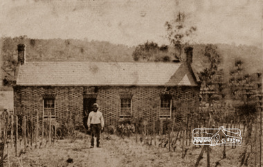
Photograph, Thomas Cochrane in front of his family home, in Little Eltham, c.1865
Originally catalogued around 1998 as John Cochrane in front of Shillinglaw Cottage, this is now believed to be Thomas Cochrane born 1817 in Ireland. The photograph is a reproduction of a low-resolution, poor-quality photograph. Shillinglaw Cottage is significant to Eltham’s local history. It is one of the earliest known buildings still in existence. Records suggest that the cottage was built circa 1859 by a man named Cochrane, believed to be Thomas Cochrane, in conjunction with George Stebbings though it is not known what Stebbings’s contribution was. It is believed Stebbings owned the cottage between 1874 and 1888. According to Margaret Ball’s (2017) book "Shillinglaw Family of Eltham 1660-2007", Thomas Cochrane and family lived there from 1867 to 1874 however this is contrary to the records of assessable rates levied by the Eltham District Road Board, established in 1858, which shows Cochrane was the owner occupier (in Little Eltham) of approximately 25 acres of cultivated land and 25 acres of pastureland upon which a hut was sited in 1860. It is suspected that George Stebbings may have acquired the property from Cochrane in 1874 as it is noted that he had a tenant for a period, James Rossiter, who was the editor for the Evelyn Observer in Kangaroo Ground in 1874 (LATE SHIRE OFFICE AT KANGAROO GROUND (1934, February 16). Advertiser (Hurstbridge, Vic. : 1922 - 1939), p. 5. Retrieved February 25, 2022, from http://nla.gov.au/nla.news-article56743657). In 1881 Phillip Shillinglaw became the ratepayer for the cottage though Stebbings retained ownership until 1888 at which time it was transferred to Shillinglaw. Thomas Cochrane was born in Ireland in 1817 and died at Collingwood 1877. He married Sarah Jane Casey at St James, Melbourne in 1846. They had eight children: • Elizabeth Jane Cochrane born 1847, Keelbundoora • Sarah Cochrane born 1849, Keelbundoora • William John Cochrane born 1854, Eltham • Isabella Mary Cochrane (Cochren) born 1855, Eltham, my Great grandmother • Mary Cochrane born 1857, Eltham • Thomas Cochrane born 1859, Eltham • William James Cochrane born 1861, Eltham • Margaret Anne Cochrane (Cochran) born 1863, Eltham Information received from Richard Stone in 2019, a 2nd-great grandson of Thomas Cochrane suggests that during the early 1930s, one of Isabella’s daughters and her family attended cricket matches at Eltham. The mother and a daughter (Richard’s cousin) would wander around Eltham and a cottage in the main street backing onto the cricket ground. The cousin remembers well her mother telling her that her mother, Isabella Cochrane, lived in the cottage as a young girl. The family also had a similar or the same photo of a man standing in front of the cottage. When the Cochrane family left the cottage in 1874, Thomas Snr would have been 57 and Thomas Jnr 15 and William 13. The man in the photo has a dark and substantial beard. Therefore, it is unlikely to be Thomas Jnr or William and most likely Thomas Snr. The photo is of poor quality and low resolution however, there is little grey evident in his beard. It was possibly taken when Cochrane was a younger man shortly after the cottage was built, circa 1865. When the Eltham District Road Board was established in 1858, the forerunner to Eltham Shire Council, Thomas Cochrane was listed as the occupier/owner of two assessable parcels of farmland in Little Eltham: one of 21 acres of pastureland and another 22 acres of cultivation land. George Stebbings was not recorded as an occupier or landowner. In 1859 and 1860 a Joseph/Joshua Stebbings was recorded as the occupier of a hut owned by G. Atkinson. A hut was recorded on Cochrane’s pastureland parcel in 1860 and this parcel increased in size to 36 acres in 1861 and grew further in size by 1863. George Stebbings first appears as the owner/occupier of a hut in Eltham in 1861, also 1862 and 1863. This is most likely his cottage (still standing in present day) in Pitt Street adjoining the Eltham Hotel property owned by Benjamin Wallis where he was residing in 1867 when they both sued each other for trespass. (POLICE. (1867, August 9). The Argus (Melbourne, Vic. : 1848 - 1957), p. 7. Retrieved February 25, 2022, from http://nla.gov.au/nla.news-article5774640) Thomas Cochrane was appointed one of the original trustees of the ground set aside for Eltham Cemetery in Feb 1860 (GOVERNMENT GAZETTE. (1860, February 11). The Argus (Melbourne, Vic. : 1848 - 1957), p. 7. Retrieved February 25, 2022, from http://nla.gov.au/nla.news-article5676991)A very early photo of Shillinglaw Cottage with its original builder and owner/occupier, Thomas Cochrane. Cochrane was also a founding Trustee of the Eltham Cemetery Trust. Reproduction of sepia photographshillinglaw cottage, eltham, eltham cemetery trust, evelyn observer, george stebbings, james rossiter, little eltham, phillip shillinglaw, thomas cochrane -
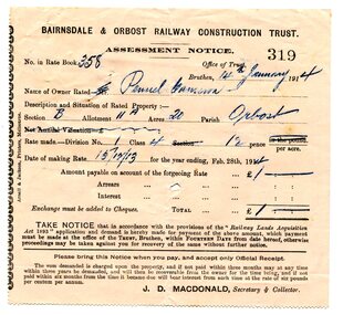 Orbost & District Historical Society
assessment notices, 1913 1914 1926
... was to acquire the land necessary for the railway and levy a rate... was to acquire the land necessary for the railway and levy a rate ...In the Orbost area a committee was formed called the Bairnsdale to Orbost Railway Trust. The business of the trust was to acquire the land necessary for the railway and levy a rate on the property owners. The other cost to the area wanting a railway was the guarantee against loss in working expenses of the railway, the Orbost Shire had to provide up to £3000 per annum. Even as late as 1913 the railway was still expected to go through Orbost and beyond. 635.3 is to Albert Trewin for 158 acres at Orbost. 635.2 is to Robert P. Cameron for 120 acres in Orbost and 635.1 is for Penuel Cameron for 20 acres in Orbost. Robert Pullar Cameron was a Shire Councillor for many years. He married Penuel Hossack and had a family of James, Flora, Penuel and Alex. Albert and Hazel Trewin farmed at Jarrahmond, just outside Orbost on the B Road. This item is associated with the history of the Orbost-Bairnsdale railway line and therefore reflects the role that the rail line played in the social and economic history of Orbost.Three paper notices of assessment. 635.1 is white with black print. 635.2 and 635.3 are pink with black print. All have hand-written details. They are from the Bairnsdale and Orbost Railway Trust.orbost-bairnsdale-railway cameron-robert-pullar trewin-albert assessment-notices -
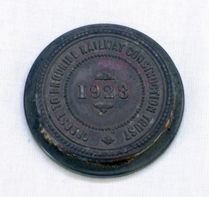 Orbost & District Historical Society
seal, 1928
... for the railway and levy a rate on the property owners. The other cost... for the railway and levy a rate on the property owners. The other cost ...On 23 December an act was passed to authorise the construction by the State (Victoria) of a line of railway from Orbost to Brodribb. Even as late as 1913 the railway was still expected to go through Orbost and beyond. In the Orbost area a committee was formed called the Bairnsdale to Orbost Railway Trust. The business of the trust was to acquire the land necessary for the railway and levy a rate on the property owners. The other cost to the area wanting a railway was the guarantee against loss in working expenses of the railway, the Orbost Shire had to provide up to £3000 per annum. The line was never constructed and the Bairnsdale to Orbost Railway terminated on the western side of the Snowy River. This item is associated with the history of the Orbost-Bairnsdale railway line and therefore reflects the role that the rail line played in the social and economic history of Orbost.A round copper disc with a metal seal on top. "Orbost to Brodribb Railway Construction Trust - 1928"seal railway orbost-bairnsdale-railway -
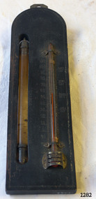 Flagstaff Hill Maritime Museum and Village
Thermometer, Early 20th Century
A Storm Glass and Thermometer such as this one would be used in predicting or forecasting the weather. Farmers used predictions they read from their Storm Glass to prepare for stormy weather or for choosing a good time for planting or harvesting their crops. This could mean to them the difference between a good year and a year without income. This design has been in use since the early 1800’s. According to Admiral Fitzroy (who studied the storm glass and wrote instructions on its use) the liquid in the glass changes composition and appearance according to the direction of the air moving around it. He advised the user to disturb the contents once or twice a year by tipping it upside down and shaking it gently. Item is a good example of a barometer/thermometer that would have been in most homes and farms from the late 19th century and early 20th century. This item would have been massed produced at the time therefore easily available and quite cheap to purchase making this particular item not very significant as not associated with a historic person or property or with a known manufacturer or date.Storm Glass and Thermometer, commonly called a 'Cottage Barometer', mounted on a rectangular dark rectangle of wood, top corners rounded. The Storm Glass (or weather glass, or chemical weather glass) is suspended in a long oval shaped hole in the wood on left side, held in place at top and at bottom with 2 metal bands secured by nails. The glass of this gauge is hand blown, sealed at the top with another layer of glass. The watery fluid in the storm glass is opaque brownish colour with dark particles floating in it. (Storm glasses were usually filled with a variation of a mix of camphor, distilled water, ethyl alcohol and silver nitrate.) The alcohol thermometer is mounted on the right side of the wood, bulb resting in a hollow, attached at top and near base by 2 thin metal strips, with clover-leaf shaped ends, nailed into place. Over the bulb is nailed a metal guard with 3 ventilation slits cut into it. On left of thermometer is a scale, stamped into wood, 30 below zero to 130 above zero, in 2 degree intervals. A border of 2 thin parallel lines, with remnants of light coloured paint, is around the block of wood. On the reverse side, a metal plate is nailed to the top with a mounting hole in it. Impressed sideways along edge of barometer is "STORMY" "CHANGE" "FAIR". Across the top of the thermometer is a fleur de leis in the wood, and above this it is stamped "FAHRENHEIT". On right of the thermometer, stamped into the wood, is "BLOOD/HEAT", "SUMR/HEAT", "TEMPE/RATE", "FREEZ/ING". On the back of the wood, at the base, are remnants of a white sticker with "...111.73". Carved into the wood is "HOLLAND / AV". flagstaff hill, warrnambool, shipwrecked coast, flagstaff hill maritime museum, maritime museum, shipwreck coast, flagstaff hill maritime village, great ocean road, barometer, cottage barometer, storm glass, thermometer, chemical weather glass -
 Glen Eira Historical Society
Album - Album page, Glenfern, Inkerman Street, Circa 1972
This photograph is part of the Caulfield Historical Album 1972. This album was created in approximately 1972 as part of a project by the Caulfield Historical Society to assist in identifying buildings worthy of preservation. The album is related to a Survey the Caulfield Historical Society developed in collaboration with the National Trust of Australia (Victoria) and Caulfield City Council to identify historic buildings within the City of Caulfield that warranted the protection of a National Trust Classification. Principal photographer thought to be Trevor Hart, member of Caulfield Historical Society. Most photographs were taken between 1966-1972 with a small number of photographs being older and from unknown sources. All photographs are black and white except where stated, with 386 photographs over 198 pages.From Victorian Heritage Database citation for Glernfern H0136 https://vhd.heritagecouncil.vic.gov.au/places/57 (as at 23/10/2020) Glenfern was built on spacious grounds at the corner of Inkerman and Hotham Streets, East St Kilda in two main stages in 1857 and 1876. From 1876 to 1984 Glenfern had only two owners, including the well known Melbourne family of artists, the Boyds. The property was bequeathed to the National Trust of Australia (Victoria) in 1984 and has remained in their ownership. The original Glenfern allotment was bought by John Bakewell in 1856 and sold the following year to Francis McDonnell, a prominent Melbourne investor. By 1858, the house, rated as the most valuable in Caulfield, had been built on the site. Due to financial difficulties, McDonnell offered a number of properties for sale in 1860, including Glenfern. It was not sold at this stage, but subsequently mortgaged in 1862. In 1866 Thomas Watson purchased the property and lived there until 1876 when it was sold to Captain John T. T. Boyd and his wife, Lucy, founders of the Boyd dynasty of artists, musicians, writers and architects. The Boyd family, including twelve children, lived there until 1907, with Lucy Boyd retaining ownership after her husband's death in 1891. In 1907 the property was subdivided and the greatly reduced Glenfern portion was purchased by the Ostberg family, who lived there from 1915. In the latter years of Boyd family ownership and the Ostberg ownership, Glenfern had several tenants and was run as a school on two occasions. The Ostberg family occupancy continued until the death of Miss Amy Ostberg in 1984. From 1929 the property was listed as Glenfern Flats, necessitating various internal alterations over a period of time. The original two storey house, attributed to architect Charles Laing, was extended for the Boyd family in 1876, by architect M. Hennessy. This comprised the addition of a two storey wing to the south of the existing building. Stables were built in 1884 by the architects Smith and Johnson and other outbuildings, since removed, were recorded on the site. The gardens were developed from the establishment of the estate and remnants of early plantings, exotic trees in particular, are evident. Various additions and alterations were made to the house in the twentieth century and a separate block of flats was built on the southern boundary in c1964. Glenfern is a two storey picturesque Gothic house of stuccoed brick with steep, gabled slate roofs, elaborate bargeboards and chimneys of conjoined stacks set diagonally. The original, asymmetrically planned L-shaped house, containing the principal rooms and a rear wing, was designed with two main facades facing north and west. The north facade contains an unusual recessed pointed arch bay formed between twin chimney flues. Internally cedar joinery includes an unusual set of double doors between the drawing room and parlour, the centre pair of which fold back and then slide into the walls. Detailing of the 1876 additions copied that of the original house, including the bargeboards, chimneys and western verandah. Ownership of Glenfern passed to the National Trust of Australia (Victoria) in 1984 and in 2002 transformation of the property into a Centre for the Arts and Culture commenced. This began with the establishment of an Artist-in-residence programme, followed by the Glenfern Writers Centre. Restoration and renovation of the building has been undertaken concurrently with the establishment of this centre. How is it significant? Glenfern, East St Kilda is of architectural and historical significance to the State of Victoria. Why is it significant? Glenfern is of architectural significance as an unusually intact and rare example of the picturesque domestic Gothic Revival house in Victoria. Of particular note are the clustered chimneys, bargeboards and twin arched chimney flues and the folding/sliding cedar doors between the principal rooms. It is significant as an important work of the prominent Melbourne architect, Charles Laing. Glenfern is of historical significance for its connection with the distinguished Victorian Boyd family. It has been recorded in a painting by Emma Boyd, wife of Arthur, in 1885 and in print by writer, Martin Boyd in 1952. Glenfern is of historical significance due to its ownership by only two families from 1876; firstly the Boyds until 1907 and the Ostbergs until 1984. Of note is the resistance to redevelopment in the latter half of the twentieth century and the subsequent survival of the 1907 Glenfern estate.Page 98 of Photograph Album with two photographs (one square and one landscape) of views of Glenfern.Handwritten: "Glenfern" 417 Inkerman Street [top right] / 98 [bottom right]trevor hart, east st kilda, garden, pitched roof, glenfern, hotham street, boyd family, 1850's, 1860's, 1870's, john bakewell, francis mcdonnell, thomas watson, lucy boyd, glenfern flats, charles laing, m. hennessy, smith and johnson, stables, gothic, stuccoed brick, gabled slate roofs, elaborate bargeboards, asymmetrical, cedar joinery, verandah, national trust of australia, centre for the arts and culture, artist-in-residence, glenfern writers centre, gothic revival, clustered chimneys, emma boyd, inkerman street, north caulfield, captain john boyd, artists, writers, st kilda east, national trust of australia (victoria), caulfield, amy ostberg, architects, m hennessy, doors, chimneys, martin boyd, arthur boyd, ostberg family -
 Glen Eira Historical Society
Album - Album page, Bureel (Kooyong Road), Circa 1972
This photograph is part of the Caulfield Historical Album 1972. This album was created in approximately 1972 as part of a project by the Caulfield Historical Society to assist in identifying buildings worthy of preservation. The album is related to a Survey the Caulfield Historical Society developed in collaboration with the National Trust of Australia (Victoria) and Caulfield City Council to identify historic buildings within the City of Caulfield that warranted the protection of a National Trust Classification. Principal photographer thought to be Trevor Hart, member of Caulfield Historical Society. Most photographs were taken between 1966-1972 with a small number of photographs being older and from unknown sources. All photographs are black and white except where stated, with 386 photographs over 198 pages. From: Glen Eira Heritage Management Plan 1996 by Andrew Ward In 1856, John Allee, a builder from Brighton, purchased C.A. 37 on the south-west corner of Glenhuntly and Kooyong Roads. The land comprised just over 45 acres. By 1863, Francis John Sidney Stephen, a lawyer and cousin of J. Wilberforce Stephen, owned most of lot 37. By 1866, Stephen had a built a "small mansion" named ''Burreel". It was a brick house and Stephen lived there until 1882. By 1884, Mrs Buxton of Hillside Terrace, East Melbourne, had purchased the property. Richard Buxton, a gentleman was listed as occupant and the house described as "brick, eight rooms". NAV was £300. Richard Buxton continued residency in 1887 however in 1888, George Allen, music seller, became occupant. At that time the house had thirteen rooms on twenty-three acres of land. Twelve people lived there and NAV was £920. In 1900, Daniel Luxton, stock and sharebroker and the Honourable John Taverner, M.H.A. leased the property. Fourteen people lived there. Mrs Buxton continued as owner. By 1910, ownership had passed to Mrs Mary Neate, who converted the house to a nursing home. The land had been subdivided by 1913 and sold by ''Buxtons Estate". Burreel Avenue, Baxter, Buxton and Hoddle Streets were created. "Burreel" was rated to Burreel Avenue and stood on lot 13 with frontages to Burreel Avenue and Kooyong Road of 198' and 214'. The house had ten rooms. NAV was £60. Mary Neate, a nurse, continued as owner/ operator of ''Burreel" nursing home in 1927. At that time there were sixteen rooms and fourteen residents. NAV was £100. Mrs Neat remained there until 1947. In 1948, the house was turned into apartments. In the 1980's, the Alexander family purchased it and restored it to a private residence.Burreel 331 Kooyong Road, ELSTERNWICK VIC 3185 - Property No B4950 National Trust https://vhd.heritagecouncil.vic.gov.au/places/65648 This is a large and substantially intact example of the grand villas of nineteenth century Melbourne. The bulk of the house most probably was built in 1866-1868 for Francis John Sidney Stephen, a prominent and highly regarded Melbourne solicitor and a member of an illustrious legal family. Stephen conducted a lucrative private practice and in 1845 was appointed first solicitor to the City of Melbourne; a position he held until his death in 1895. He took an active part in the development of Caulfield and was Shire President in 1874 and 1877. He was a resident at Burreel from 1868 to 1882. The house has evolved in stages, the rear wings possibly remaining from a house built during the 1850s. The existing ornate cast iron verandah was probably built between 1882 and 1888 during the residence of Richard Buckhurst Buxted, a notable boom period auctioneer and real estate agent. George Allan, the founder of Allan's music store, was another important occupier from 1888 to 1991. Bureel's essentially residential quality has been retained and the interior has been well preserved. The significance of this building does not rest in any single unusual outstanding architectural feature, or in its association with a particularly prominent member of society in the past, but rather in the consistent integrity of both the interior and exterior, which results in the survival of an outstanding example of this type of residential building and its associations with two notable citizens. Classified:11/08/1990Page 113 of photograph album with 1 photograph of Burreel in its garden.Handwritten: Bureel [top left] / 113 [bottom left]trevor hart, caulfield, caulfield north, kooyong road, thomas king, mansion, 1860's, bureel, burreel, francis john sidney stephen, city of melbourne, shire president, 1850's, verandah, nursing home, john allee, ornamented corner stones, new orleans manner, plaster rendered, mrs luxton, vincent willis, alexander family, victorian architectural style, ornate cast iron work, lawyers, brick houses, richard buxton, richard buckhurst buxton, george allen, george leavis allan, allans music, daniel luxton, john taverner, mary neate, buxtons estate, land subdivision, mary neat, gardens -
Glen Eira Historical Society
Document - NEWSPAPER PUBLISHED OR CIRCULATED IN CAULFIELD
This file contains four items: 1/Two typed lists of the names and years of circulation of Elsternwick and Caulfield Newspapers held at the Caulfield Library, the first with amendments in ballpoint pen and the second a revised version of the first dated 12/07/1988. Also included in the item is a typed list of what appears to be issues of the Southern Cross newspaper held at the library and an original handwritten list with a black and white photocopy of newspapers held at the Caulfield Library, dated 11/09/1988. These were provided by Gladys Vallati (longtime member; Head Librarian of Caulfield Library for many years). 2/Two extracts from the Caulfield Historical Society Newsletters (issues April 1975 No 15 and June 1975 No 16) detailing newspapers published and or circulated in Caulfield that are held at the State Library of Victoria, both undated and author unknown. The first has some handwritten annotations and a minute from the first meeting of the Caulfield Road Board on 25/11/1857 on the reverse side, listing the surnames of those present. Also included in the item is a typed draft for one of the extracts. 3/A six page handwritten list of newspapers circulated in the area of Caulfield held in Australian libraries, taken from a Union List dated 1967 in the Canberra National Library, author unknown. Details given of the newspapers include the title and dates of issue, in some cases also listing the merging of newspapers and ceasing of publication. Attached is a handwritten note detailing the production history of the Caulfield and Elsternwick Advertiser dated October 1980, author unknown. 4/A file note dated 24/02/2021 noting that the acompanying typed list of the titles, eras of publications and storage location of newspapers held at Glen Eira Historical Society dated September 2008, is out of date and superceded.elsternwick, buzz, glenhuntly advertiser caulfield communication activities, the elsternwick advertiser, libraries, newspapers elsternwick times caulfield library, the caulfield star southern cross documents, the caulfield advertiser, the age, the caulfield mercury and glenhuntly guardian, the elsternwick and caulfield herald, the elsternwick and caulfield mercury, the caulfield and elsternwick star, the caulfield and elsternwick times caulfield elsternwick advertiser, caulfield and elsternwick leader the caulfield and elsternwick advertiser caulfield contact caulfield news australia israel review, regional progress jerusalem post international edition australian jewish news, the elsternwick leader, microforms, caulfield bibliography brighton , malvern , oakleigh, prahran, carnegie courier, the observer, south east suburban mail, elsternwick news caulfield road board meetings, board meetings caulfield historical society, caulfield historical society newsletter victorian government gazette, the argus, caulfield city council caulfield city council rate books , books, rate books, minute books, harris mr , brooks mr , semple mr, handasyde gilbert, nelson mr, dempsey mr, grants, financial economics, brighton independent, brighton leader, brighton news, brighton southern cross, southern weekly, sunshine times, malvern advertiser, malvern and armadale express, malvern and armadale recorder, malvern argus, malvern courier and caulfield mirror, malvern news, malvern press, malvern spectator, malvern standard, southern news, ormond news, prahran telegraph, oakleigh and caulfield times, chadstone progress, property review weekly, glen eira historical society newsletter, glen eira caulfield leader, glen eira news, south east suburban mail, brighton independent, bentleigh echo, bentleigh news, bentleigh standard, prahran and st kilda advertiser, prahran chronicle, prahran news, prahran post, the times, daily mail, esplanade post, st kilda advertiser, st kilda and balaclava news, st kilda and caulfield southern cross, st kilda district guide, st kilda chronicle, st kilda mercury, st kilda news, oakleigh local news, oakleigh advertiser, oakleigh and caulfield times, oakleigh and mulgrave guardian, oakleigh leader, oakleigh southern cross, standard times -
Glen Eira Historical Society
Article - Service Family
This file contains three items Printed article on James Service from the Australian Sketcher, dated 13/03/1880 Printed article from Victorian and Its Metropolis, by Sutherland, undated Handwritten article on James Service, one short summary taken from Cannon-Land Boomers (page 31) undated. Additional paragraph noting “Servicton” named after him. Handwritten undated list of properties held by James Service from 1876 to 1872, from Rate Books possibly.service james, politian’s, merchants, premiers, kilwinning, house names, mansions, hotham street, balaclava road, james service and co., caulfield north