Showing 82 items
matching the deep mines of bendigo
-
 Bendigo Historical Society Inc.
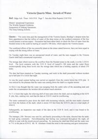
Document - DRAINAGE PROBLEMS - INRUSH OF WATER AT THE VICTORIA QUARTZ
Two handwritten copies of a Bendigo Advertiser report 16/6/1910 Page 7. This is a longer version of 3600.14. It was thought that the rush of water was from a dam bursting in one of the other mines, but as the water showed no signs of slowing that theory was discarded. The temperature of the incoming water was much higher than the Victoria Quartz was accustomed to bail, and this circumstance is significent in view of the increased temperature of the water at the deep levels in the New Chum Railway. Some months ago, the water commenced to flow from the New Chum Railway workings into the New Shenandoah, which is the next mine north. The water rose so rapidly that a disaster was narrowly averted. The mines along the line were connected at different levels and with the cessation of bailing at the deep levels in the southern mines, it was only to be expected that the water would find its way north to the Victoria Quartz. The water raised from the operating mines under the direction of the New Chum Drainage Association, a yeart or two ago used to exceed six million gallons per month. At that time there were eight companies bailing water, and even then some of the plants, especially those at the deep mines, were severely taxed in coping with the water, and performing ordinary work. Since some mines had discontinued bailing, the water has been filling up extensive workings, and as was predicted in the ''Advertiser'' some time ago, the Victoria Quartz Company could not expect to succeed with its deep sinking project without making some special provision for raising the water, which ultimately would become a source of trouble. The Victoria Quartz Company was allotted a special grant of 10,000 pound to assist in sinking the shaft 1000 ft from the 4254 ft level. Under the conditions of the grant, the Company had to contribute half the cost of the sinking, and the raising of the water has also been an exensive item. For the present, all attention will be concentrated in lowering the water, and should the appliances prove unequal to the task the deep sinking scheme can only be accomplished by resorting to some comprehensive system of combating the water'. Document from Albert Richardson Collection of mining history.document, gold, drainage problems, drainage problems, inrush of water at the victoria quartz, bendigo advertiser 16/6/1910 page 7, mine reports 13/6/1910, victoria quartz, lansell's 180, mr stevens, mr w abraham, new chum & victoria mine, new chum railway, new shenandoah, new chum drainage association -
 Bendigo Historical Society Inc.
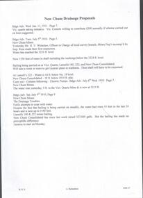
Document - DRAINAGE PROBLEMS - NEW CHUM DRAINAGE PROPOSALS
Six pages of handwritten notes regarding the New Chum Drainage Proposals. Extracts from the Bendigo Advertiser mentioning the rising of the water in the New Chum Mines. An Advertiser report 27/12/1910 mentions that deep mining will have to be abandoned owing to the absence of some proper scheme to cope with the water. An arrangement had been made by which the companies affected along the line should contribute to a scheme. Suggestions made that the water be lifted by electric pumps. Baling with tanks had been tried for 6 months and then abandoned. Directors Report Victoria Reef Quartz Jan 1911 mentions unwatering had been carried on with assistance of Government. On the 20th Dec, one rope gave out. Decided that replacing it and doing the necessary work could not be met in the present financial conditions. It was also considered that the costof trying to reach the bottom reefcut in the New Chum Railway could not be continued by baling as its cost proved too expensive, while it could probably be done economically & effectively by electric pump which is now subject to negotiations with the Mining Dept.' At the end of the report is a Balance Sheet. Document from Albert Richardson Collection of mining history.document, gold, drainage problems, drainage problems, new chum drainage proposals, bendigo advertiser 11/1/1911 page 7, victoria quartz, victoria consols, bendigo advertiser 5/7/1910 page 3, mr h v whitelaw, mines dept, insp ross, lansell's 180, 222, new chum consolidated, lazarus, bendigo advertiser 6/7/1910 page 7, 9/7/1910 page 9, drainage troubles, bendigo advertiser 8/7/ page 8, new chum railway, south belle vue, eureka ext'd, bgo adv 25/7 1910, 27/12/1910 page 2, rae's machine, bendigo advertiser 2/1/1911, mr mcbride, mines dept, mr stanfield, mines act, bendigo advertiser 16/1/1911 page 3, victoria reef quartz half yearly meeting 1911, directors report and balance sheet, geo paynting -
 Bendigo Historical Society Inc.
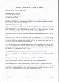
Document - DRAINAGE PROBLEMS - MINERS SENSATIONAL EXPERIENCE AT THE VICTORIA QUARTZ
Handwritten notes from a Bendigo Advertiser report, Thursday June 16th 1910. Management had for some time been apprehensive that the flooding in the deep mines to the south would affect them. Lansell's 180 took the precaution of baling. On the Tuesday night the men at the Victoria Quartz had a sensational experience. The storage dam at 3324 ft level receives the overflow from the flooded mines to the south. The level connects with the 3310 level at the Big 180. The water flows uninterrupted into thestorage dam which has a capacity of about 270 tanks. The dam had been emptied on Tuesday morning and work continued until 10 pm that night. The platman noticed that the water was coming down the shaft in a regular torrent. They didn't take much notice as they thought it was a leakinig outlet valve on the ascending tank. At 11 pm the releiving shift came down the shaft and said that the dam at 3,324 ft must be overflowing. The velocity of the water pouring down the shaft increased and the men made a hurried exit from the bottom of the shaft which is down 310 ft from the 4.254 ft plat (a total depth of 4,564 ft). An inspection of the dam at the 3324 ft level found it to be overflowing. By morning (Wednesday) the shaft had filled, and the water rose to 7 ft in the plat at 4254 feet. Mining inspector hgave orders that men were not to go below the 3324 ft level. Baling continued without cessation at the Big 180 all day and could not lower the water. Drilling machines etc and a powerful air winch at the 4254 ft plat are under water. An inspection made of the 3100 ft level at the 180 mine where the workings are connected with the New Chum & Victoria showed that water was running strongly from that mine proving that the inrush was due to flooded water from the southern deep mines to the south. Document from Albert Richardson Collection of mining history. Document from Albert Richardson Collection of mining history.document, gold, drainage problems, new chum drainage scheme, miners sensational experience at the victoria quartz, bendigo advertiser 16/6/1910 page7, lansell's 180, big 180, new chum & victoria -
 Bendigo Historical Society Inc.
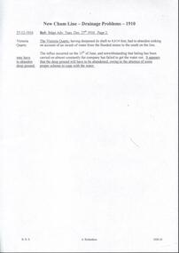
Document - DRAINAGE PROBLEMS - NEW CHUM LINE DRAINAGE PROBLEMS 1910
Handwritten extract from the Bendigo Advertiser 27/12/1910 Page 2. ''The Victoria Quartz, having deepened its shaft to 4,614 feet, had to abandon sinking on account of an inrush of water from the flooded mines to the south on the line. The influx occurred on the 15th of June, and notwithstanding that baling has been carried on almost constantly the company has failed to get the water out. It appears that the deep ground will have to be abandoned, owing to the absence of some proper scheme to cope with the water.'' Albert Richardson Mining History Collection.document, gold, drainage problems, drainage problems, new chum line drainage problems 1910, bendigo advertiser 27/12/1910 page 2, victoria quartz, albert richardson -
 Bendigo Historical Society Inc.
Document - MINING REPORTS - FAMOUS GOLD MINES OF BENDIGO AND EAGLEHAWK
Handwritten notes by Albert Richardson, titled 'Famous Gold Mines of Bendigo and Eaglehawk'. Notes include gold yields, deep shafts in 1904 and 1911, shafts of more than 4,000 feet, shafts between 3.020 and 3,682 feet and the reef line they were on, wages for different mine workers and a reference to winding engines and air compressors. Miner's mentioned: Ballerstadt, Wittscheibe, Lufffmans, Burrows, Sterry, Lazarus, Koch, Hidebrandt, Watson and George Lansell.gold, mining reports, mining reports, famous gold mines of bendigo and eaglehawk, the victoria quartz, new chum railway, miners wages, albert richardson -
 Bendigo Historical Society Inc.
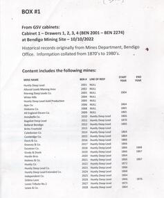
Document - MINING WARDEN COLLECTION
Historical mining records originally from the Mining Warden's Office, Mines Department, Bendigo. A summary document lists the mine name; the BEN #; the line of reef located on, the start and end year. Information collated from 1870's to 1980's. Each mine's data is enclosed in a manilla folder within the box. Mines along the following reef lines are described: Huntly Deep Lead Whipstick Neilborough Drover Isabella Slaughteryard Blue Jacket Tyson One Tree Hill Flag Gravel Hill View Hill Lightning Hill Hustlers Ben # range from 2001 to 2274. Example of entry: Pascoe and Symmonds, Ben # 2217, Lightning Hill Reef, 1863-1885.bendigo, mining, mining warden records -
 Bendigo Historical Society Inc.
Document - MINING REPORTS -DEPARTMENT OF MINES, REPORT ON OBSERVATIONS OF UNDERGROUND TEMPERATURE AT BENDIGO
Printed Report on Observations of Underground Temperature at Bendigo, by James Stirling, Government Geologist. Report mentions temperature increases as the mines get deeper, temperature of air and rocks, Meteorological Observations at 180 Mine, Bendigo, comparison temperature in other parts of the world and Bendigo, Temperature of air at the 180 Mine, Shenandoah Mine, victoria Quartz, Shamrock, Great Extended Hustlers, Princess Dagmar and United Hustlers and Redan, Daily Variation of Temperature and Pressure of the Air, Temperature of Fault Line, Drawing of Lansell's No 180 Mine showing levels, geological features, graph of Curves of Atmosphere Pressure at 180 Mine Bendigo, graph of Curves of Temperature at 180 Mine Bendigo, Lansell's 180 Mine Rate of Aincrease of Rock Temperature, Comparisons with Observations in other Countries, Observations in November and December 1895, Meteorological Observations at New Chum Railway Mine Bendigo, Kiagram of working 'ends' showing temperatures therein at the New Chum Railway Mine Bendigo Vic, Additional Observations at Lansell's 180 Mine, Shamrock, Princess Dagmar, United Hustlers and Redan and Great Extended Hustler's, Humidity with formula which was adopted, Hygrometer Observations, The Ventilating Currents (and formula), Notes on Anemometer Records 180 Mine, Tabulated List showing Velocities of Air Currents at Various Levels in the 180 Mine Bendigo, Pressure of Air (and formula), Composition of the Air at Lansell's 180 Mine, Shamrock, Princess Dagmar, Gt Extended Hustlers and United Hustlers and Redan and Miners' Complaints. A Richardson name written on the top right corner.A. Richardson, 29 Harrison St., Bendigogold, mining reports, mining reports, report on observations of underground temperature at bendigo, department of mines, james travis, the hon henry foster, james stirling, 180 mine, shenandoah mine, victoria quartz, shamrock, great extended hustlers, princess dagmar, united hustlers and redan, new chum railway mine, north old chum, m grehauf, dr boyd, robt s brain -
Bendigo Historical Society Inc.
Newspaper - Albert Ernest Richardson, Peter Anderson's article 2020
Albert Richardson was born on 22nd. June, 1902 to George Albert Richardson and Catherine Agnes (nee Flynn). He married Mavis Irene Yarwood on 23rd. December, 1931. Albert Richardson's childhood activities in Duncan Street, Long Gully, were influenced strongly by the occupation of his father and grandfather, both of whom were engine drivers on the Bendigo field. Albert had his own model goldmine, complete with poppet head, baling tanks etc and was up and ready to start work with the sound of the 7 a.m. mine whistles. Albert spent a short time working as a motor mechanic and then took up0 welling insurance with T & G. However, his heart was with the mines and he worked daytimes with T. & G. and then took off to learn engine driving with night shift in one of the mines. He gained his engine drivers' ticket in 1938 and began work at the Nell Gwynne. His longest work time was at the North Nell but he also had shorter spells at other mines. His leter work years were spent at John Brown, from where he retired in 1968. Albert had a deep regard for the working man and worked for many years in the position of Secretary at the Trades Hall, Bendigo. (adapted from biography in BHS Collection, written by I. Hendry, 1972) The Bendigo Historical Society holds a wide range of Bendigo mining records researched and written by Mr. Albert Richardson. He was President of the Bendigo Branch of the Royal Historical Society of Victoria from 1969 to 1971.When he joined the Bendigo Branch in 1966 he began compiling a history of the Bendigo mines. He spent many long hours researching at the Bendigo Mines Department, summarising mine records. He gathered relevant mining material wherever it could be obtained. He devoted most of his spare time and energy to the Society, conducting tours of the goldfields, writing articles and presenting talks to various organisations. His first and foremost interest lay in Victoria Hill. He examined mining reports and early newspaper articles to document its history. He envisaged the once fabulously rich hill as becoming a tourist attraction and campaigned vigorously to achieve this. In 1971 his dream was realised, when, with the help of South Bendigo Rotary Club 'The Hill' was cleaned up and historical site4s sign-posted. In 1972 the Bendigo Trust produced a booklet on Victoria Hill. Albert Richardson is acknowledged as the person ' on whose work and writings the text of this booklet has been based' The park adjoining Victoria Hill was named the Albert Richardson Reserve in his honour. Four newspaper clippings on mining, focusing on Albert Richardson's life; his passion for mining history and more generally, the work of engine drivers on the Bendigo goldfield. Clippings taken from the 'Bendigo Weekly' 2016, dated September 29 'Learner Drivers' , October 7 'Becoming qualified', October 14 'Steam power in his veins' and November 11 ' Victoria Hill over the decades'. All articles written by James Lerk in a series titled 'Discover Bendigo'. albert richardson, engine driver, mining, bendigo, boiler, engine room, mining cage, albert richardson reserve, victoria hill, george ellis, south bendigo rotary club -
 Bendigo Historical Society Inc.
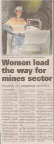
Newspaper - Article on Miner Elisabeth Viklund, July 17 2022
Elisabeth Viklund has been recognised by the Mineral Council of Australia's Women in resources award.Bendigo Advertiser half page article entitled 'Women lead the way for mines sector' with coloured photo of worker in front of a loader deep below the earth's surface.bendigo, elisabeth viklund, mandalay's gold and antimony mine at costerfield -
 Bendigo Historical Society Inc.
Map - STRUGNELL COLLECTION: HUSTLER'S Royal Reserve Shaft No. 2 Bendigo, September 1913
Map, Hustler's Line of Reef, Hustler's Royal Reserves No. 2 Co, Longitudinal Section.Plate No.V111 (8). Bulletin No 33 Signed H.A.Whitelaw Underground survey Office Bendigo September 1913 Drawing shows mine shaft to over 1746 feet deep and appears to show samples of connecting horizontal shaftsUnderground Survey Office, Bendigo.map, bendigo, hustler's royal reserve no. 2 mine* -
 Bendigo Historical Society Inc.
Document - ALBERT RICHARDSON COLLECTION: VICTORIA HILL IRONBARK
Three page document hand written by Albert Richardson, on the history of Victoria Hill, Ironbark. 'one of the richest areas on Bendigo field. In the first six years, £1,200,000 worth of gold was obtained. Almost every claim returned a fortune.' Page three title: Other features on Victoria Hill. 'Adjacent to Central Nell Gwynne area as the mining museum. Adjacent to the New Chum Hill on direct south side of the Calder Highway. This hill reached by a short and excellent access road gives a magnificent view of Bendigo and Golden Square, and a very good view of another tourist attraction, Lansells 'Fortuna' now Survey Regiment's headquarters. This hill is the centre of another rich area. The Lazarus mine 3,360 feet deep with 24 saddle reefs in 2,200 feet. The New Chum United, Lansell's 222with its 120 ft high poppet legs. BCV 8, John Brown Knitwear factory, Esposito's Gold Mines Hotel, Central Nell Gwynne and Manchester tram loops are mentioned.Albert Richardsonbendigo, mining, victoria hill -
 Bendigo Historical Society Inc.
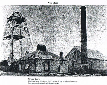
Photograph - LONG GULLY HISTORY GROUP COLLECTION: VICTORIA QUARTZ
BHS CollectionCopy of a black and white photo of the Victoria Quartz Mine showing the poppet head, chimney and two buildings. Printed underneath is: Victoria Quartz. The head frame here is the third erected. It was needed to cope with increased haulage as the shaft went deeper.bendigo, history, long gully history group, the long gully history group - victoria quartz -
 Bendigo Historical Society Inc.
Document - NEW CHUM LINE OF REEF MUNGO GROUP EAGLEHAWK
Two page document detailing the Mungo Group of Mines along the New Chum line of reef, Eaglehawk. The mines described are: Ellenborough, 2100 feet deep St Mungo, 2,600 feet deep The Lady Barkly, 1,350 feet deep, close to Upper Road with a 40 head battery on the other side. South St Mungo, known as the Governor Barkly in the earlier days. Small map on second page shows the location of the Sadowa shaft, St. Mungo shaft and the Lady Barkly shaft. Victoria Street and Upper Road marked on the map. 'Between Caldwells Road and Victoria Street and Upper Road intersection, nine mines and three crushing batteries worked at one period. All on the New Chum line of reef.' Not signed but most probably written by Albert Richardson.bendigo, mining, mungo group of mines, eaglehawk -
 Bendigo Historical Society Inc.
Document - Regulation of Mines Bill, famous mines of Bendigo, April, 2014
Seven men were killed at the Great Extended Hustler's mine disaster on 2nd May 1914 by an explosion of dynamite occurring as the men were waiting at the plat to ascend the mine at the end of their shift. No blame was attached to anyone in the findings of the inquisition. It was unknown what caused the dynamite to explode. Three page typed document. First page: 'The Regulation of Mines Bill' by Albert Richardson; Angus Mackay, Minister of Mines introduced the Bill in the Legislative Assembly on October 16th 1873 and it became law on January 1st 1874. Second page: 'Famous Gold Mines of Bendigo and Eaglehawk' by Albert Richardson, discusses deep shafts, more than 4000 feet shafts, wages for 1911. Hustler's Line of Reef mines are listed from north to south: Hustler Consols; United Hustler's and Redan, K.K., Comet, Hustler's Reef No. 1, Hustlers Reef, Great Extended Hustlers (formed 4.2.1865) Hustler's Royal Reserve Co., (Park Shaft) Hustler's Royal Reserve (City Shaft) and Fortuna Hustler's (formed August 1888).great extended hustlers, goldmining, accident, quartz, mining, k.k. mine, comet mine, hustler's line of reef, old comet, united hustler's, redan -
 Bendigo Historical Society Inc.
Document - VICTORIA HILL - THE RICH VICTORIA HILL AND ITS HISTORICAL ASSOCIATIONS
Copy and a photocopy of notes titled 'The rich Victoria Hill and its Historical Associations. The photocopy does not have copies of the photos. Notes include Introduction, directions for getting to Victoria Hill, North Old Chum Mine 2310 ft deep, Ballerstedt's First Open Cut, Geographical Features, Lansell's Big 180, Crushing Battery, Lansell's Cleopatra Needle type chimney, Victoria Quartz Mine 4613 ft deep, Victoria Reef Quartz Company, Victoria Quartz Company, Victoria Quartz Dams, Rae's Open Cut, Quartz Roasting, Floyd's small 5 Head Crushing Battery, Great Central Victoria (Midway) Shaft, Ballerstedt's Small 24 yard Claim, The Humboldt, The Adventure, The Advance and Luffsman and Sterry's Claim. Copies of photos include: Victoria Hill from Rae's Open Cut, Looking North from Old Chum Hill to the Victoria Hill, the Victoria Quartz Mine and Wm. Rae's Crushing Works.document, gold, victoria hill, the rich victoria hill and its historical associations, j n macartney, quartz miners' arms hotel, ironbark methodist church, john brown knitwear factory, little 180, george lansell, conrad heinz, british and american hotel, victoria reef gold mining company, manchester arms hotel, housing commission homes, the ironbark, hercules and energetic, midway, wittscheibe, great central victoria, wm rae, mr & mrs conroy, moorhead's shop, central nell gwynne, gold mines hotel, david chaplin sterry, new chum & victoria, old chum, burrowes & sterry, rotary club of bendigo south, big 180, north old chum mine, ballerstedt's first open-cut, lansell's bit 180 shaft, victoria quartz mine, victoria reef quartz company, a roberts & sons, mr e j dunn, h harkness & sons, new chum drainage scheme, eureka extended, new chum railway, the pearl, inrush of water, shamrock, shenandoah, victoria quartz dams, rae's open cut, floyd's small 5 head crushing battery, great central victoria (midway) shaft, midway no 2, midway north, the humboldt, the adventure, the advance, luffsman & sterry's claim, chinese joss house, fortuna, p m g repeater station, bendigo and vicinity 1895, j n macartney 1st edition 1871, mr rae anderson, 'gill family, annals of bendigo obituary notices 1904, mining records and australian mining standard special edition 1/6/1899, bendigo advertiser 22/6/1871, b m l records mines department, patterson's goldfields of victoria, dickers mining record 23/11/1861, annals of bendigo, bendigo advertiser 24/7/1933, 27/8/1908, 30/6/1910, 16/6/1910, 17/6/1910, mining reports for 1910, australian mining standard special edition 1/6/1899 p40, bendigo mines ltd, mines department records, the bendigo goldfield 1851 to 1954, the victoria hill 1854 to 1949, wm rae's crushing works -
Bendigo Historical Society Inc.
Photograph - AUSTIN COLLECTION: Ray Beer, Central Deborah Gold Mine
Ray Beer was an employee of the Central Deborah Gold Mine. February 15th 2009: Bendigo Advertiser: 'MINING stalwart Raymond Beer has died at the age of 74 after a battle with cancer. He leaves behind an extended family and a legacy in Bendigo’s mining history. Ray was mine manager at the Central Deborah Gold Mine - appointed in 1978 - and led the team that made possible the underground project at the second level. He had a vision to allow visitors to go underground and experience Bendigo’s mining heritage first hand. Ray was responsible for developing the new battery, shaft and poppet head to make this a reality. It took persistence and lots of hard work. Friend and work colleague Bill McNamara said Ray was as good as 10 men. His enthusiasm and work ethic were unprecedented. Ray will be sadly missed by his wife, Thelma, six children, 15 grandchildren, seven brothers, three sisters, his extended family, and friends. He will be remembered for his kindness, tenacity and strength of character. In recognition of his contribution to Bendigo’s mining history, after more than 20 years of service at his retirement, a bronze life-sized statue was unveiled in his honour'. Central Deborah Gold Mine history: At its peak, Central Deborah Gold Mine reached a depth of 412 metres. It has 17 separate levels and 15 kilometres of drives and cross cuts (tunnels). The Central Deborah was very much a hands-on mine and the conditions that the miners worked in would be considered shocking by today's standards – being lowered underground in a cage with only two sides, often working ankle to knee deep in water, filling up to 32 ore trucks a shift by hand which were then pushed a mile or more along rails in the drives, working by carbide lamp, breathing in the fumes and rock dust and communication by bells. Geez, they were ironmen. However, at the time working conditions were considered to be among the best on the goldfields at Central Deborah, after all it was one of the only mines that had hot showers. Following Central Deborah Gold Mine's closure, the Bendigo skyline began to noticeably change. Obvious remnants of mining such as poppet heads, engine rooms, service quarters, battery houses and chimneys were steadily disappearing. After intense lobbying by the local community, the Bendigo City Council purchased the still very much intact Central Deborah Gold Mine in 1970 for a mere $6,000 to ensure that a vital link to Bendigo's historic golden past was maintained. The Bendigo Trust was then formed to oversee the operations of the Central Deborah Gold Mine, which led to the surface of the mine being opened to the public in 1971. Initially the surface was open for just 12 hours a week and as the demand for viewing a part of Bendigo's history increased, so did the opening hours. In 1974 the mine was gazetted as a Public Historical Purposes Reserve and attracted such visitors as H.R.H Prince Charles. By far the greatest shortcoming at this stage was that no one could view the underground workings, as these had become flooded. After what could only be described as a monumental effort by everyone involved, Level 2 of the mine was officially opened to the public by the Premier of Victoria, the Honourable John Cain, on 20 June 1986, which brought to fruition a long standing dream.Black and white photograph. Ray Beer, underground at Central Deborah Gold Mine, standing alongside wooden sign 'Murrell's Corner'. Sign is placed horizontally on timber supports; side of drive visible in background. Ray is wearing bib and brace overalls and hard hat with a belt around his waist. He is giving a 'thumbs up' sign. gold mining, central deborah gold mine, ray beer, mine manager -
Bendigo Historical Society Inc.
Photograph - AUSTIN COLLECTION: Central Deborah Gold Mine Lift Shaft
Central Deborah Gold Mine history: At its peak, Central Deborah Gold Mine reached a depth of 412 metres. It has 17 separate levels and 15 kilometres of drives and cross cuts (tunnels). The Central Deborah was very much a hands-on mine and the conditions that the miners worked in would be considered shocking by today's standards – being lowered underground in a cage with only two sides, often working ankle to knee deep in water, filling up to 32 ore trucks a shift by hand which were then pushed a mile or more along rails in the drives, working by carbide lamp, breathing in the fumes and rock dust and communication by bells. Geez, they were ironmen. However, at the time working conditions were considered to be among the best on the goldfields at Central Deborah, after all it was one of the only mines that had hot showers. Following Central Deborah Gold Mine's closure, the Bendigo skyline began to noticeably change. Obvious remnants of mining such as poppet heads, engine rooms, service quarters, battery houses and chimneys were steadily disappearing. After intense lobbying by the local community, the Bendigo City Council purchased the still very much intact Central Deborah Gold Mine in 1970 for a mere $6,000 to ensure that a vital link to Bendigo's historic golden past was maintained. The Bendigo Trust was then formed to oversee the operations of the Central Deborah Gold Mine, which led to the surface of the mine being opened to the public in 1971. Initially the surface was open for just 12 hours a week and as the demand for viewing a part of Bendigo's history increased, so did the opening hours. In 1974 the mine was gazetted as a Public Historical Purposes Reserve and attracted such visitors as H.R.H Prince Charles. By far the greatest shortcoming at this stage was that no one could view the underground workings, as these had become flooded. After what could only be described as a monumental effort by everyone involved, Level 2 of the mine was officially opened to the public by the Premier of Victoria, the Honourable John Cain, on 20 June 1986, which brought to fruition a long standing dream.Black and white photograph, looking from bottom of lift shaft towards the surface; light visible at top of shaft. Lift cables and safety mesh on sides of shaft. gold mining, central deborah gold mine, ray beer, mine manager -
Bendigo Historical Society Inc.
Photograph - AUSTIN COLLECTION: Central Deborah Gold Mine, Possibly 1990's
Central Deborah Gold Mine history: At its peak, Central Deborah Gold Mine reached a depth of 412 metres. It has 17 separate levels and 15 kilometres of drives and cross cuts (tunnels). The Central Deborah was very much a hands-on mine and the conditions that the miners worked in would be considered shocking by today's standards – being lowered underground in a cage with only two sides, often working ankle to knee deep in water, filling up to 32 ore trucks a shift by hand which were then pushed a mile or more along rails in the drives, working by carbide lamp, breathing in the fumes and rock dust and communication by bells. Geez, they were ironmen. However, at the time working conditions were considered to be among the best on the goldfields at Central Deborah, after all it was one of the only mines that had hot showers. Following Central Deborah Gold Mine's closure, the Bendigo skyline began to noticeably change. Obvious remnants of mining such as poppet heads, engine rooms, service quarters, battery houses and chimneys were steadily disappearing. After intense lobbying by the local community, the Bendigo City Council purchased the still very much intact Central Deborah Gold Mine in 1970 for a mere $6,000 to ensure that a vital link to Bendigo's historic golden past was maintained. The Bendigo Trust was then formed to oversee the operations of the Central Deborah Gold Mine, which led to the surface of the mine being opened to the public in 1971. Initially the surface was open for just 12 hours a week and as the demand for viewing a part of Bendigo's history increased, so did the opening hours. In 1974 the mine was gazetted as a Public Historical Purposes Reserve and attracted such visitors as H.R.H Prince Charles. By far the greatest shortcoming at this stage was that no one could view the underground workings, as these had become flooded. After what could only be described as a monumental effort by everyone involved, Level 2 of the mine was officially opened to the public by the Premier of Victoria, the Honourable John Cain, on 20 June 1986, which brought to fruition a long standing dream.Black and white photograph. Two men with hard hats and lights, inspecting quartz outcrop on wall of drive at Central Deborah Gold Mine.gold mining, central deborah gold mine, ray beer, mine manager -
Bendigo Historical Society Inc.
Photograph - AUSTIN COLLECTION: Operating rock drill, Central Deborah Gold Mine, Possibly 1990's
Central Deborah Gold Mine history: At its peak, Central Deborah Gold Mine reached a depth of 412 metres. It has 17 separate levels and 15 kilometres of drives and cross cuts (tunnels). The Central Deborah was very much a hands-on mine and the conditions that the miners worked in would be considered shocking by today's standards – being lowered underground in a cage with only two sides, often working ankle to knee deep in water, filling up to 32 ore trucks a shift by hand which were then pushed a mile or more along rails in the drives, working by carbide lamp, breathing in the fumes and rock dust and communication by bells. Geez, they were ironmen. However, at the time working conditions were considered to be among the best on the goldfields at Central Deborah, after all it was one of the only mines that had hot showers. Following Central Deborah Gold Mine's closure, the Bendigo skyline began to noticeably change. Obvious remnants of mining such as poppet heads, engine rooms, service quarters, battery houses and chimneys were steadily disappearing. After intense lobbying by the local community, the Bendigo City Council purchased the still very much intact Central Deborah Gold Mine in 1970 for a mere $6,000 to ensure that a vital link to Bendigo's historic golden past was maintained. The Bendigo Trust was then formed to oversee the operations of the Central Deborah Gold Mine, which led to the surface of the mine being opened to the public in 1971. Initially the surface was open for just 12 hours a week and as the demand for viewing a part of Bendigo's history increased, so did the opening hours. In 1974 the mine was gazetted as a Public Historical Purposes Reserve and attracted such visitors as H.R.H Prince Charles. By far the greatest shortcoming at this stage was that no one could view the underground workings, as these had become flooded. After what could only be described as a monumental effort by everyone involved, Level 2 of the mine was officially opened to the public by the Premier of Victoria, the Honourable John Cain, on 20 June 1986, which brought to fruition a long standing dream.Black and white photograph. Two men with hard hats and lights standing in front of underground rock surface at Central Deborah Gold Mine. Man on left hand side of image is operating a small rock drill. Man on right hand side is observing the procedure. gold mining, central deborah gold mine, rock drill, underground -
Bendigo Historical Society Inc.
Photograph - AUSTIN COLLECTION: Williams United Mine Eaglehawk, Possibly 1990's
Black and white photograph. Two underground miners inspecting a promising sample from a strong quartz vein at the face. Photo is duplicate of image published in the Bendigo Advertiser (no date). Text on newspaper image: Deep in the Williams United mine at Eaglehawk miners examine promising samples from a strong quartz vein at the face. To the left is Western Mining's Bendigo residential manager Colin Cruickshank and to the right underground shift boss for the mining contractors, Eltin Pty Ltd Wetner Borchert.gold mining, underground, quartz vein, williams united gold mine, eaglehawk -
 Bendigo Historical Society Inc.
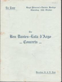
Document - ROYAL PRINCESS'S THEATRE, BENDIGO-BEN DAVIES, ESTA D'ARGO CONCERTS, 26 Oct, 1911
Royal Princess's Theatre, Bendigo. Thursday, 26th October 1911. The Ben Davies - Esta d'Argo Concerts, Direction J & N Tait. Solo Pianist - Herr Edward Goll. Accompanist - Mr. William Conway. Pictures of Mr. Ben Davies and Miss Esta d'Argo on page 1. Program on page 3 to 6. Program of Pianoforte Solos, Recitative & Cavatina, Recitative & Air, Songs: Pastorale, Menuette Vecchio, Capriccio, Ernani, involame, Deaper and Deeper Still, Waft her Angels, Study, Schuerzo, Where the Bee Sucks, Mu Mother bids me Bind my Hair, The Bonnie Blue 'Kerchief, Drink to Me only with Thine eyes, O a' the Airts, Y Gnew Fach, It is not because your Heart is Mine, My Dreams, Una Notte a Venezia (words to all songs included). Advertising on inside front cover, page 2, 7,8, inside back cover and back cover. Advertising for Melbourne businesses and The Victorian Railways and Allan's Cover is blue, all print is blue. Cover plus pages 8. Marking none.Lake Sons & Cowell, 34 Queen Street, Melbourneprogram, music, bendigo, royal princess theatre -
 Bendigo Historical Society Inc.
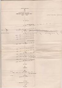
Map - COMET MINE - TRANSVERSE SECTION COMET MINE
Transverse section of the Comet Mine on the Hustler's Line of Reef Bulletin No 33, Plate No XXV signed by H. A. Whitdon, Underground Survey Office Bendigo September,1913. Map shows depth of the different levels, the type of stone and shaft about 2020 deep. A number of smaller drawings on the side. Reference explaining the different types of stone, etc. Geological Survey of Victoriamining, hustler's line of reefs, transverse section of comet mine bulletin no 33 plate no xxv, lightning hill line of reef