Showing 1122 items matching " waterways"
-
 Lakes Entrance Historical Society
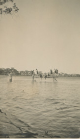
Photograph, Gippsland Lakes Swimming, 1925
Black and white photograph showing eight people in swimming costume on a rustic diving platform in a waterway in the Gippsland Lakes tourism, gippsland lakes, social history, fashion -
 Lakes Entrance Historical Society
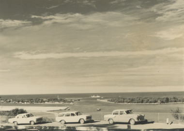
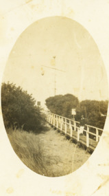
Photograph - Views from Jemmys Point, Lakes Entrance c1960, 1960 c
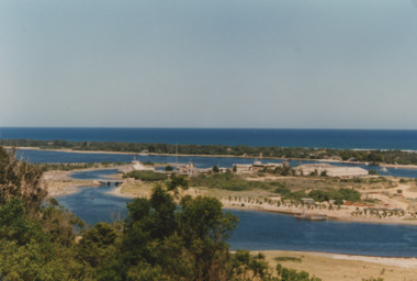
... Waterways ...Black and white photograph of the entrance taken from a bend in the Princes Highway showing three cars parked at the viewing area beside the highway. Boat and dredge in waterway below highway dredged sand in Bullock Island extension, dredge Mathew Flinders working outside the entrance Lakes Entrance Victoria. Also two black and white photographs taken of Entrance from Jemmys Point taken 1960 c waterways, vehicles, islands, roads and streets -
 El Dorado Museum Association Inc.
Photograph (item) - Digital Image
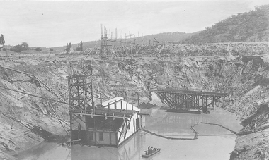
Cocks Pioneer Barge with new pump and punt. Cocks Pioneer Electric Gold & Tin Mine Company was formed in 1899. The company's first power station, located at the eastern end of the valley began operating with its 340 Kilowatt steam-powered generator. By 1909, from 2,500,000 cubic yards worked, reported recovery was 17,284 ounces of gold and 224 tons of tin ore. By 1909, Cocks Pioneer’s power plant had become inadequate and uneconomical. The barge was floated downstream about a mile, but lost time caused the operations to cease. Following testing, a new mine was established by diverting Reid's Creek at a cost of £25,000. Settling dams were built, one of which held 1,935,900 cubic feet. Sold earth banks, built against a wall of stringy bark saplings constructed and laced with vertical props, were built. In 1914, the company was reformed as Cock’s Pioneer Gold and Tin Mines NL, another power station was constructed at the western end of the township, near the junction of Clear and Reid's Creeks. From 6,800,000 cubic yards of material processed, the returns were 64,397 ounces of gold and 855 ton of tin. Cocks Pioneer mine then moved the barge downs stream and continued sluicing. In 1929 Cocks Pioneer Electric Gold and Tin Mining Company ceased operations due to a drop in values. Cock’s Pioneer Gold and Tin Mines NL carried on large-scale hydraulic sluicing operations until 1941. mines, mining, gold, tin, gold mining, tin mining, watercraft, punt, boats, men, cocks pioneer, el dorado, eldorado -
 Linton and District Historical Society Inc
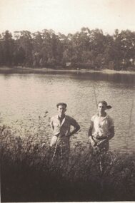
Photograph, Ivan and Lyle Grigg
Small black and white image of two men standing at the edge of a waterway. Believed to be Linton Reservoir, Mortchup Road, Linton.ivan grigg, lyle grigg -
 Lakes Entrance Historical Society
Photograph, Lakes Post Newspaper, 1994
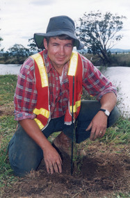
Colour photograph of Paul Broome planting a tree beside a waterway during catchment authority revegitation project East Gippsland Victoriarevegitation -
 Glenelg Shire Council Cultural Collection
Photograph - Photograph - Rural Scene two men standing on bank of waterway, n.d
Black and white photo attached to heavy card. Lighter area around print. Rural scene, two men standing on bank of waterway.Back: 'largo/fargo Class 1' - black ink -
Whitehorse Historical Society Inc.
Document, Open space between Yarran Dheran and Schwerkolt Cottage, 2001
Report of an open space assessment by Melbourne Parks and Waterways land between Yarran Dheran and Schwerkolt Cottage.Report of an open space assessment by Melbourne Parks and Waterways land between Yarran Dheran and Schwerkolt Cottage. Council Paper PROP/016781Report of an open space assessment by Melbourne Parks and Waterways land between Yarran Dheran and Schwerkolt Cottage. yarran dheran, nunawading and district historical society inc., schwerkolt cottage -
 Orbost & District Historical Society
black and white photograph, late 19th - early 20th century
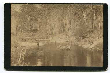
In the late 1800's early 1900's transporting goods by road was difficult and at times impossible because roads as thoroughfares did not exist.The means of travelling along the roads in the 1800's was by bullock wagon, horse pulled dray, pack horse or simply by foot. This is a pictorial record of transport in the mid 18th - early 19th century. Pack horses were vital for the delivery of goods, responding to emergencies as they could travel in country inaccessible to larger horse - drawn carts or wagons.A black / white photograph on a black buff card. It is of a group of pack horses being guided across a waterway with a man on horseback on either side of the river.transport pack-horses -
Glenelg Shire Council Cultural Collection
Photograph - Photograph - Rural scene, n.d
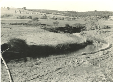
Black and white photo mounted on dark grey card, with lighter border around print. Rural scene, waterway, derelict fence, gums, reeds.Back: 'View near Portland' largo/fargo class 1 - pen -
 Sunbury Family History and Heritage Society Inc.
Photograph, Bulla Bridge, c 1980s
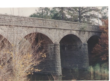
The bridge in the photograph is the bluestone bridge at Bulla which spans the Deep Creek, a tributary of the Maribyrnong River. It was built in 1869 and replaced a ford crossing which was built further downstream. Many of the buildings and structures in the area were built from bluestone which is in abundance throughout this volcanic area.This bridge is one of many similar structures built across Western Victoria where the bluestone volcanic rock was found in abundance.A coloured close - up photograph of a four-arched blue stone bridge spanning a waterway. Some greenery is visible on either side of the bridge and above it. bulla bridge, bluestone, bridges, deep creek. -
 Federation University Historical Collection
Photograph - Glass Plate, Henry Sutton, Hertford Lock by Henry Sutton, c1891
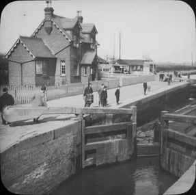
Henry Sutton was born in Ballarat into the musical Sutton Family. He is known as an important Australian inventor. Photograph of Hertford Lock. lockkeepers house. A lock is a device used for raising and lowering boats, ships and other watercraft between stretches of water of different levels on river and canal waterways. Hertford Lock is situated on the River Lea on the eastern side of Hartham Common, Hertford in the English county of Hertfordshire. It is owned and managed by British Waterways and is the first lock of the River Lee Navigation.henry sutton, glass plates, photography, swans -
 Lakes Entrance Historical Society
Photograph - Bullock Island Lakes Entrance, M Holding, 1988 c
... Waterways ...Kalimna Heights showing development on Bullock Island including Pecks Factory. The Club Spit of dredged sand is acquiring vegetation. April Hamer dredge moored at Port Jetty, new bridge in place Lakes Entrance VictoriaAlso two colour photographs showing dumped sand on Bullock Island taken from Princes Highway lower parking bay June 2000. Donor L P Newspaper number 04209.1 size 10 x 15 cm and 04209.2 size 10 x 15 cm|Two colour photographs of Gippsland Ports Facilities taken from waterway numbers 04208.3 and 04208.4 size 10 x 15 cmColour photograph taken from Kalimna Heights showing development on Bullock Island including Pecks Factory. The Club Spit of dredged sand is acquiring vegetation. April Hamer dredge moored at Port Jetty, new bridge in place Lakes Entrance Victoriaislands, waterways, gippsland lakes -
 Lakes Entrance Historical Society
Photograph - Lake Bunga, M Holding, 1990c
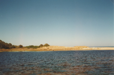
Colour photograph of eastern shore near the entrance to ocean, the low area between upland and sand dune indicating the original waterway Lake Bunga Victoriatopography, waterfront -
 Lakes Entrance Historical Society
Postcard - North Arm bridge Lakes Entrance Victoria, 1917c
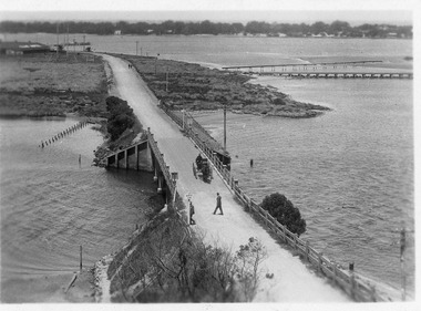
... Waterways ...Also sepia toned photographic print 10cmx15cm, good condition old cat No 310 or 318? (Club Hotel and Hummocks area cropped from top) also Black and white photographic print 12.5cmx18cm, good condition- 2 copies 'Original T-Beam bridge opened Sept 1917 on reverse P01151-3.Black and white photographic miniature postcard showing the concrete bridge over the North Arm, showing the extended abutments, and shortened bridge length compared to previous bridge, causing restriction of waterway. Two walkers and horse drawn vehicle, buggy, on bridge. Remaining piles of wooden bridge upstream of bridge, telegraph poles upstream of bridge and across mudflats. Bridge to Bullock Island from mudflat, Club Hotel, Cunninghame Arm, and sand hummocks in distance. Lakes Entrance Victoriabridges, waterways, coast, transport, hotels -
 Lakes Entrance Historical Society
Photograph, 1940
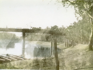
Black and white photograph of a railway bridge over waterway on railway line at unknown location. Boat at edge of water has small load of log timbers across it. Victoriabridges, transport, vegetation -
 Lakes Entrance Historical Society
Photograph, G Legg Bairnsdale, Tambo River at Mossiface Victoria, `1970 1980 c
This narrow waterway was the original steamer route to the Port of MossifaceBlack and white photograph of the Tambo River adjoining Arthur Howletts property at Mossiface Victoriaboats and boating, rivers -
 Bendigo Military Museum
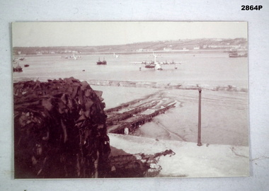
Photograph - PHOTOGRAPH, AIRFORCE, c.WWII
Photo, black & white, showing a waterway with several Sunderland Air Craft moored, some boats & shipping. On left in foreground shows a large object covered in some sort of camouflage.photography-photographs, military history - air force, passchendaele barracks trust -
 Lakes Entrance Historical Society
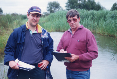
Photograph - Tambo Water Board, Lakes Post Newspaper, 1999
Colour photograph of Robin Minter Mitchell River Supervisor and Simon Robertson East Gippsland Catchment Authority Engineer beside a waterway during a training course East Gippsland Victoriawater resources -
 Lakes Entrance Historical Society
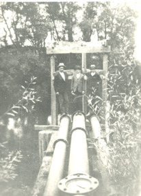
Photograph - mining in Gippsland Victoria, 1920 c
Black and white photograph showing three men standing at three water pipes beside a waterway which appears to be an abandoned pumping station perhaps associated with mining in Gippsland Victoriatopography, transport -
 Federation University Historical Collection
Map, Ballaarat Gold Field, 1861, 21/10/1861
A party of surveyors camped by Yuille's Swamp (later Lake Wendouree) and surveyed the countryside for a map to be produced by the Geological Survey of Victoria. In November 2004 the Central Highlands Regional Library presented a special edition of 200 copies of the 1861 map reproduced from a copy in their collection. Original geological map of Ballarat showing property, waterways, mines, churches, schools, water races, and garden reserves. It was compiled and drawn from the surveys of Mining Surveyors Davidson, Fitzpatrick and Cowan.Compiled & Drawn from the Survey of Mining Surveyors Davidson, Fitzpatrick and Cowan & the Plans in the Surveyor General's Office by J. Brahe, 21st October 1861. R. Brough Smyth, Secretary for Mines. The Honourable J.B. Humffray, M.L.A. Commr of Mines.ballarat, map, davidson, robert brough-smyth, fitzpatrick, cowan, yuille's swamp, public garden reserve, manure depot, black hill, ballarat east, old post office hill, pennyweight hill, claytons hill, golden point, mining, railway, cricket ground, swamp creek, cemetery, sludge reserve, bakery hill, gaelic church, juvenile reformatory, orphanage, specimen hill, eureka lead, cattle yard hill, dalton's flat, chinese village, poverty hill, railway reserve, little bendigo diggings, pound reserve, allied armies, flour mill, agricultural reserve, marsh, survey reserve, survey corps, white flat, yarrowee, yarrowee creek, brache, j. brache, survey, ballaarat gold field 1861 -
 Hume City Civic Collection
Photograph, Bulla Mill
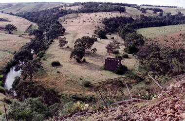
The waterway is the Deep Creek at Bulla. Originally this was the site of one of the earliest mills in the district.In the early days of European settlement a number of mills were established on the banks of both the Jackson and Deep Creeks in Bulla and Sunbury.A coloured photograph of a valley surrounded by hills with the ruins of a stone building on the horseshoe bend of the creek. deep creek, mills, bulla bulla -
 Parks Victoria - Days Mill and Farm
Container - Traps
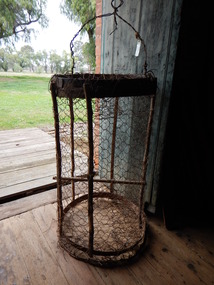
Possibly used for catching freshwater crayfish or yabbies, nearby in the Goulburn River or other waterways. of critical significanceHOMEMADE WIRE TRAPS x 2. Made from chicken wire. Iron bands supported by green timber lengths. Wire handles with metal spike probably for securing trap to bank/ ground.fishing, food -
 Bendigo Military Museum
Photograph - PHOTOGRAPH, AIR FORCE, C. WW2 onwards
Photo, black & white, this is a distant shot showing patchy/cloudy sky. There is a waterway in the centre with 8 Sunderland Aircraft moored in it. The Tactical Air Command are facing left. The foreground shows buildings, a crane & trees.photography-photographs, military history - air force, sunderland, passchendaele barracks trust -
 Federation University Historical Collection
Photograph - black and white, Cologne Cathedral from the Rhine, c1950
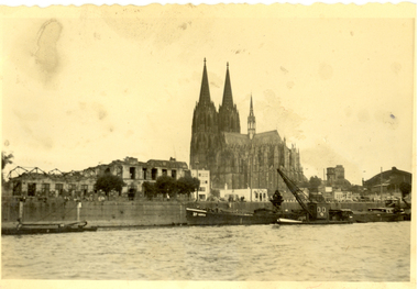
Cologne Cathedral is a renowned monument of German Catholicism and Gothic architecture and is a World Heritage Site. It is Germany's most visited landmark, attracting an average of 20,000 people a day. (Wikipedia) Though not targeted itself, the cathedral was very near to the central railway station and suffered fourteen hits by aerial bombs during World War II. Badly damaged, it nevertheless remained standing in an otherwise completely flattened city. The twin spires were an easily recognizable navigational landmark for Allied aircraft bombing deeper into Germany, which may explain why the cathedral was spared. Repairs were completed in 1956. An emergency repair on the northwest tower's base carried out in 1944 using poor-quality brick taken from a nearby ruined building remained visible until 2005 as a reminder of the war, when it was decided to restore the section its original appearance. (Wikipedia) Black and white photograph showing a grand cathedral from a waterway. It is Cologne (Koln) Cathedral from the Rhine. To the left of the photo bombed buildings are evident. The photograph is believed to have been taken by Frank Wright.cologne cathedral, koln, germany, rhine, bombing, world war two, frank wright -
Ballarat Heritage Services
Photograph - Video, Clare Gervasoni, Confluence of Canadian Creek and Yarrowee River near Anderson Street, Ballarat, 06/09/2022
The waterways of central Ballarat were channeled to prevent flooding and contain sludge during the mining era.Video of the confluence of Canadian Creek and Yarrowee River near Anderson Street, Ballarat flowing down a channel.canadian creel, yarrowee river, ballarat, anderson street, channel, bluestone -
Ballarat Heritage Services
Photograph - Video, Clare Gervasoni, Specimen Vale Creek at Steinfeld Street, Ballarat, 06/09/2022
The waterways of central Ballarat were channeled to prevent flooding and contain sludge during the mining era.Video of Specimen Vale Creek at Steinfeld Street, Ballarat., Ballarat flowing down a channel.ballarat, channel, bluestone, specimen vale creek, steinfeld street -
 Lakes Entrance Historical Society
Photograph - Signal Station New Works, 1930 c
Also a black and white photograph of view of entrance with a steamer at sea and steamer Tamar in waterway 05277.1Black and white photograph of walkway to signal station at New Works Lakes Entrance Victorianavigation -
 Lakes Entrance Historical Society
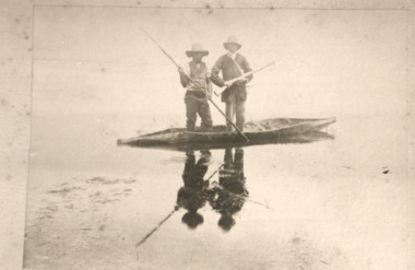
Photograph - Aboriginal canoe on Lake Tyers Victoria, H D Bulmer, 1905 c
Sepia toned photograph of two men one with spear other with gun standing in native canoe on Lake Tyers Victoria. Also sepia photographs of natives in three bark canoes on edge of waterway at Lake Tyers parks, recreational facilities -
 Ballan Shire Historical Society
Map - Map. Ballark, Department of Lands and Survey, Ballark. County of Grant, 31/08/1915
A map of the Ballark area within the County of Grant showing roads, waterways, property boundaries and property owners in 1915.Significant to people researching land usage and ownership. Also those researching families in the area at that time.A map of Ballark in the County of Grant. Black printing on buff coloured paper. Extra notations by hand and various coloured highlighting of certain features. Details roads, rivers, property boundaries and names of property owners and districts. The map is easily readable although there is some physical damage to the borders and some sellotape residue. Shows a scale in Chains and the number L.6030Various numbers and directional arrows added to map.bungal, borhoneyghurk, bungeeltap, ballark, beremboke, moreep, meredith, morrisons, moorarbool river -
 Lakes Entrance Historical Society
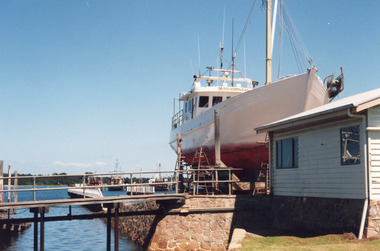
Photograph - Maramingo, Lakes Post Newspaper, 2000
Photo appeared in Lakes Post 12 January 2000Colour photograph of Gippsland Ports facility at Eastern Wharf. Timber fishing vessel Maramingo on slips, timber shed on land nearby, rock wall at edge of waterway, three fishing vessels in Cunninghame Arm. Lakes Entrance Victoriaships and shipping, fishing industry