Showing 303 items matching "aqueduct"
-
 Eltham District Historical Society Inc
Photograph, Liz Pidgeon, Heritage Excursion; Maroondah Aqueduct, 3 September 2016, 3 September 2016
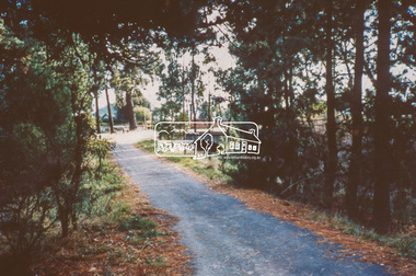
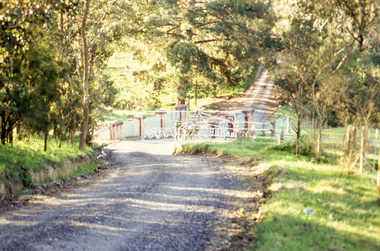
Newsletter No., 229, August 2016 Heritage Excursion - Maroondah Aqueduct Walk - Saturday 3rd September The Maroondah Aqueduct was once a major link in Melbourne’s water supply system. It was built between 1886 and 1891 to transfer water from the Watts River near Healesville to the Preston Reservoir. It was 66 km in length, made up of 41 km of open channel, 10 km of tunnel through hills and 15 km of pipeline across stream valleys known as inverted siphons. The section of the aqueduct through the Eltham area has been abandoned since the 1980s but the open channel has largely been retained. A recreational path follows the aqueduct reserve. For our excursion on 3rd September we intend to walk along the section of the aqueduct adjacent to Allendale Road. This is a section not visited on previous excursions and includes the transition from open channel to the inverted siphon across the Diamond Creek valley. Apart from the aqueduct itself the main feature of the walk is the extensive views across Eltham North and Diamond Creek. Along the way we will talk about the history of the aqueduct and the area. This easy walk is about 3 km return and will take 2 to 2.5 hours. It will start at 2pm at the junction of Allendale Road with Godber Road and Zig Zag Road North, officially Diamond Creek, but on the northern boundary of Eltham. (Melway ref.12 B10). Born Digitalmaroondah aqueduct, eltham north, activities, eltham district historical society, heritage excursion, aqueduct trail -
 Eltham District Historical Society Inc
Photograph, Liz Pidgeon, Heritage Excursion; Maroondah Aqueduct, 3 September 2016, 3 September 2016
Newsletter No., 229, August 2016 Heritage Excursion - Maroondah Aqueduct Walk - Saturday 3rd September The Maroondah Aqueduct was once a major link in Melbourne’s water supply system. It was built between 1886 and 1891 to transfer water from the Watts River near Healesville to the Preston Reservoir. It was 66 km in length, made up of 41 km of open channel, 10 km of tunnel through hills and 15 km of pipeline across stream valleys known as inverted siphons. The section of the aqueduct through the Eltham area has been abandoned since the 1980s but the open channel has largely been retained. A recreational path follows the aqueduct reserve. For our excursion on 3rd September we intend to walk along the section of the aqueduct adjacent to Allendale Road. This is a section not visited on previous excursions and includes the transition from open channel to the inverted siphon across the Diamond Creek valley. Apart from the aqueduct itself the main feature of the walk is the extensive views across Eltham North and Diamond Creek. Along the way we will talk about the history of the aqueduct and the area. This easy walk is about 3 km return and will take 2 to 2.5 hours. It will start at 2pm at the junction of Allendale Road with Godber Road and Zig Zag Road North, officially Diamond Creek, but on the northern boundary of Eltham. (Melway ref.12 B10). Born Digitalmaroondah aqueduct, eltham north, activities, eltham district historical society, heritage excursion, aqueduct trail, open channel -
 Eltham District Historical Society Inc
Photograph, Liz Pidgeon, Heritage Excursion; Maroondah Aqueduct, 3 September 2016, 3 September 2016
Newsletter No., 229, August 2016 Heritage Excursion - Maroondah Aqueduct Walk - Saturday 3rd September The Maroondah Aqueduct was once a major link in Melbourne’s water supply system. It was built between 1886 and 1891 to transfer water from the Watts River near Healesville to the Preston Reservoir. It was 66 km in length, made up of 41 km of open channel, 10 km of tunnel through hills and 15 km of pipeline across stream valleys known as inverted siphons. The section of the aqueduct through the Eltham area has been abandoned since the 1980s but the open channel has largely been retained. A recreational path follows the aqueduct reserve. For our excursion on 3rd September we intend to walk along the section of the aqueduct adjacent to Allendale Road. This is a section not visited on previous excursions and includes the transition from open channel to the inverted siphon across the Diamond Creek valley. Apart from the aqueduct itself the main feature of the walk is the extensive views across Eltham North and Diamond Creek. Along the way we will talk about the history of the aqueduct and the area. This easy walk is about 3 km return and will take 2 to 2.5 hours. It will start at 2pm at the junction of Allendale Road with Godber Road and Zig Zag Road North, officially Diamond Creek, but on the northern boundary of Eltham. (Melway ref.12 B10). Born Digitalmaroondah aqueduct, eltham north, activities, eltham district historical society, heritage excursion -
 Eltham District Historical Society Inc
Photograph, Liz Pidgeon, Heritage Excursion; Maroondah Aqueduct, 3 September 2016, 3 September 2016
Newsletter No., 229, August 2016 Heritage Excursion - Maroondah Aqueduct Walk - Saturday 3rd September The Maroondah Aqueduct was once a major link in Melbourne’s water supply system. It was built between 1886 and 1891 to transfer water from the Watts River near Healesville to the Preston Reservoir. It was 66 km in length, made up of 41 km of open channel, 10 km of tunnel through hills and 15 km of pipeline across stream valleys known as inverted siphons. The section of the aqueduct through the Eltham area has been abandoned since the 1980s but the open channel has largely been retained. A recreational path follows the aqueduct reserve. For our excursion on 3rd September we intend to walk along the section of the aqueduct adjacent to Allendale Road. This is a section not visited on previous excursions and includes the transition from open channel to the inverted siphon across the Diamond Creek valley. Apart from the aqueduct itself the main feature of the walk is the extensive views across Eltham North and Diamond Creek. Along the way we will talk about the history of the aqueduct and the area. This easy walk is about 3 km return and will take 2 to 2.5 hours. It will start at 2pm at the junction of Allendale Road with Godber Road and Zig Zag Road North, officially Diamond Creek, but on the northern boundary of Eltham. (Melway ref.12 B10). Born Digitalmaroondah aqueduct, eltham north, activities, eltham district historical society, heritage excursion, aqueduct trail -
 Eltham District Historical Society Inc
Photograph, Liz Pidgeon, Heritage Excursion; Maroondah Aqueduct, 3 September 2016, 3 September 2016
Newsletter No., 229, August 2016 Heritage Excursion - Maroondah Aqueduct Walk - Saturday 3rd September The Maroondah Aqueduct was once a major link in Melbourne’s water supply system. It was built between 1886 and 1891 to transfer water from the Watts River near Healesville to the Preston Reservoir. It was 66 km in length, made up of 41 km of open channel, 10 km of tunnel through hills and 15 km of pipeline across stream valleys known as inverted siphons. The section of the aqueduct through the Eltham area has been abandoned since the 1980s but the open channel has largely been retained. A recreational path follows the aqueduct reserve. For our excursion on 3rd September we intend to walk along the section of the aqueduct adjacent to Allendale Road. This is a section not visited on previous excursions and includes the transition from open channel to the inverted siphon across the Diamond Creek valley. Apart from the aqueduct itself the main feature of the walk is the extensive views across Eltham North and Diamond Creek. Along the way we will talk about the history of the aqueduct and the area. This easy walk is about 3 km return and will take 2 to 2.5 hours. It will start at 2pm at the junction of Allendale Road with Godber Road and Zig Zag Road North, officially Diamond Creek, but on the northern boundary of Eltham. (Melway ref.12 B10). Born Digitalmaroondah aqueduct, eltham north, activities, eltham district historical society, heritage excursion, aqueduct trail -
 Eltham District Historical Society Inc
Slide - Photograph, Maroondah Aqueduct, Ingrams Road, Research, c.Aug. 1978
35mm colour positive transparency Mount - Grey and Whiteaqueduct, ingrams road, maroondah aqueduct, research (vic.) -
 Greensborough Historical Society
Article - Article - Website, Wallaby Creek Weir, Aqueduct and associated sites, Kinglake, 2007
A short history of Kinglake's Wallaby Creek Weir and aqueduct in relation to Melbourne's water supply. Paper copy of website article, 7 p. text.melbourne water supply, kinglake, wallaby creek weir, aqueducts -
 Clunes Museum
Document - ARCHITECTURAL DRAWINGS, VICTORIAN WATER SUPPLY DEPARTMENT, CLUNES WATER SUPPLY, 9TH JULY 1870
DRAWINGS, CLUNES WATER SUPPLY. DRAWING No 11, CONTRACT No 2. SHOWING AQUEDUCT WORKS, UPPER AQUEDUCTclunes, water supply, drawings, aqueduct -
 Eltham District Historical Society Inc
Photograph, Liz Pidgeon, Heritage Excursion; Maroondah Aqueduct, 3 September 2016, 3 September 2016
Heritage Excursion - Maroondah Aqueduct Walk - Saturday 3rd September The Maroondah Aqueduct was once a major link in Melbourne’s water supply system. It was built between 1886 and 1891 to transfer water from the Watts River near Healesville to the Preston Reservoir. It was 66 km in length, made up of 41 km of open channel, 10 km of tunnel through hills and 15 km of pipeline across stream valleys known as inverted siphons. The section of the aqueduct through the Eltham area has been abandoned since the 1980s but the open channel has largely been retained. A recreational path follows the aqueduct reserve. For our excursion on 3rd September we intend to walk along the section of the aqueduct adjacent to Allendale Road. This is a section not visited on previous excursions and includes the transition from open channel to the inverted siphon across the Diamond Creek valley. Apart from the aqueduct itself the main feature of the walk is the extensive views across Eltham North and Diamond Creek. Along the way we will talk about the history of the aqueduct and the area. This easy walk is about 3 km return and will take 2 to 2.5 hours. It will start at 2pm at the junction of Allendale Road with Godber Road and Zig Zag Road North, officially Diamond Creek, but on the northern boundary of Eltham. (Melway ref.12 B10). Newsletter No., 229, August 2016 Abandoned and rusted house base probably purposed to water or feed cattle. Born Digitalmaroondah aqueduct, eltham north, activities, eltham district historical society, heritage excursion, bath, acqueduct trail -
 Eltham District Historical Society Inc
Photograph, Tom Prior, Maroondah Aqueduct, Research, Vic, c.1895
Built for opening in 1891 to take water from Maroondah to Reservoir. Part of a slide show presentation "Bridges & Waterways of the Shire" by Russell Yeoman to the 13 September 1989 Society meeting. The presentation included slides of historic photos from the Shire of Eltham Pioneers collections as well as several recent views.This photo forms part of a collection of photographs gathered by the Shire of Eltham for their centenary project book,"Pioneers and Painters: 100 years of the Shire of Eltham" by Alan Marshall (1971). The collection of over 500 images is held in partnership between Eltham District Historical Society and Yarra Plenty Regional Library (Eltham Library) and is now formally known as the 'The Shire of Eltham Pioneers Photograph Collection.' It is significant in being the first community sourced collection representing the places and people of the Shire's first one hundred years. The Reynolds family were early settlers in Research. The Reynolds/ Prior collection of photographs were taken by Tom Prior, the maternal uncle of Ivy Reynolds, around 1900 and the 60 photos in the album give a fine overview of many of the landmarks of Research and Eltham over 100 years ago. lvy lived in the family home for many years at 106 Thompson Cres Research. Ivy's father, Ernst Richard Reynolds and grandfather, Richard Reynolds, lived at the same address. Ivy's father Richard worked for Mr. Trail on his property in Research. Reynolds Road is named after the family. Mr Tom Prior (wife Eva) worked at the Melbourne zoo. He was very innovative and made his own camera, using the black cloth hood to exclude the light. The photographs are a reminder of the rural nature of Research and Eltham and its rich heritage.Digital image (Neg copy missing)shire of eltham pioneers photograph collection, research (vic.), maroondah aqueduct, aqueduct, reynolds prior collection -
 Eltham District Historical Society Inc
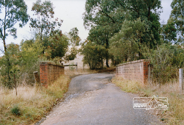
Photograph, Parsons Road Bridge over the Aqueduct, Eltham, 1991, 1991
Colour photographmaroondah aqueduct, aqueduct, bridge, eltham, parsons road -
 Greensborough Historical Society
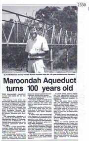
Newspaper clipping, Diamond Valley Leader, Maroondah Aqueduct turns 100 years old, 1991c
Aqueduct of 66 km built between 1886 and 1891 between Watts River near Healesville and Preston Reservoir. Parts have been replaced by pipes.The aqueduct formed a major link in Melbourne's water distribution system after supplies from Yan Yean Reservoir were considered insufficient in the 1870s.Photographic copy, text with photo of Russell Yeomansmaroondah aqueduct, russell yeomans -
 Eltham District Historical Society Inc
Photograph, Parsons Road Bridge over Maroondah Aqueduct near Margaret Street, Eltham, 1991
Colour photographmaroondah aqueduct, aqueduct, bridge, eltham, parsons road, margaret street -
 Eltham District Historical Society Inc
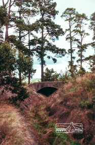
Photograph, Ingrams Road Bridge over Aqueduct, Research
Colour photographmaroondah aqueduct, aqueduct, bridge, ingrams road, research (vic.), scan - 35mm negative -
 Eltham District Historical Society Inc
Photograph, Ingrams Road Bridge over Aqueduct, Research
Colour photographmaroondah aqueduct, aqueduct, bridge, ingrams road, research (vic.), scan - 35mm negative -
 Eltham District Historical Society Inc
Photograph, Ingrams Road Bridge over Aqueduct, Research
Colour photographmaroondah aqueduct, aqueduct, bridge, ingrams road, research (vic.), scan - 35mm negative -
 Eltham District Historical Society Inc
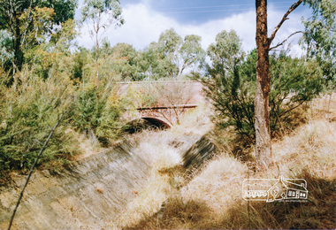
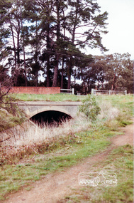
Photograph - Digital Photograph, Alan King, Maroondah Aqueduct Siphon Bridge over the Plenty River, 26 January 2008
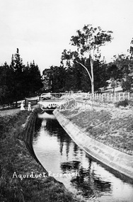
Opened in 1891, the bridge formed part of the Maroondah Aqueduct carrying water from Watts River near Healesville to the reservoir at Preston where it joined Melbourne's metropolitan water system. Covered under Heritage Overlay, Nillumbik Planning Scheme. Published: Nillumbik Now and Then / Marguerite Marshall 2008; photographs Alan King with Marguerite Marshall.; p99 Built to supply thirsty Melbourne in the late 19th century, the siphon bridge spanning the Plenty River off Leischa Court, Greensborough, was part of an engineering masterpiece. Opened in 1891, the bridge formed part of the Maroondah Aqueduct carrying water from the Watts River near Healesville to the reservoir at Preston where it joined the metropolitan distribution system. A major link in Melbourne’s water supply, it also had a huge impact on communities, which mushroomed along its route. Named after the Aboriginal word for the area around the Maroondah Reservoir, the Maroondah Aqueduct was fully operational until the 1970s. Since the 1980s the land along parts of the aqueduct have been used for walking and bicycle riding, shaded in places by Monterey Pine trees planted to stabilise the surrounding ground. From 1857 the Yan Yean Reservoir supplied Melbourne’s water but the growing city needed additional catchments.1 In 1886 work began on a weir on the Watts River to enable the aqueduct to carry most of the river water 41 miles (66km) to Melbourne. The aqueduct, built by the Board of Works, is the oldest remaining aqueduct near Melbourne and was probably the first built with concrete.2 Although the aqueduct is now only used between the Maroondah and Sugarloaf Reservoirs, it can still be traced across the Shire. It extends from the Maroondah Reservoir through Christmas Hills, Kangaroo Ground, Research, Eltham, St Helena and then previously wound west through Greensborough to Reservoir.3 Built by horse and manpower the aqueduct gravity fed 25 million gallons (113.6ML) of water a day to Melbourne along a gradient of one foot to the mile. It included 25 miles (41km) of open concrete and brick channel, six miles (10km) of tunnels, and nine miles (15km) of 14 inverted siphons of riveted wrought-iron across creeks. Bricks for the aqueduct were made from clay found near the sites and remains of several kilns can still be found between Kangaroo Ground and Christmas Hills. Building the aqueduct transformed local communities. An abattoir was established at Christmas Hills. Grog shanties and labourers’ camps sprang up and local courts dealt with cases of ‘petty pilfering and boisterous behaviour’.4 The Kangaroo Ground school population jumped to 91, crammed into a room with one teacher. Miners who built the tunnels camped just north of Churinga in Greensborough – then called Tunnel Hill Camp – and adjacent to the Evelyn Arms Hotel. The miners’ high spirits were sometimes quenched in horse troughs or by a ‘welt under the ear and kick on the behind’ as the local constable calmed them down rather than lock them up.5 But the growing city of Melbourne needed more water, so the O’Shannassy catchment, east of Warburton, was added to the system in 1914. In 1920 work began on the present concrete Maroondah Dam one mile (1.6km) from the weir on the Watts River. The aqueduct capacity was thus doubled to 50 million gallons (227ML) a day.6 Intense land development threatened to pollute the open water supply, so channel sections were replaced with large pipes. In the late 1960s a large water main was built from the tunnel outlet at Research and extended through St Helena and Greensborough, so this section of the aqueduct was taken out of use. Long sections of the unused open channels in Greensborough and Bundoora were destroyed, but the old channel in Research and Eltham North remained largely intact. In the 1970s, the Sugarloaf Reservoir was constructed, inundating 445 hectares of land in Christmas Hills. Sugarloaf was officially opened in 1980 and serves as a water storage and treatment plant supplying Melbourne. In the early 1980s pipes replaced the section from Sugarloaf Reservoir to the tunnel entrance at Kangaroo Ground. The Research-Kangaroo Ground tunnel operates as part of the pipeline system.This collection of almost 130 photos about places and people within the Shire of Nillumbik, an urban and rural municipality in Melbourne's north, contributes to an understanding of the history of the Shire. Published in 2008 immediately prior to the Black Saturday bushfires of February 7, 2009, it documents sites that were impacted, and in some cases destroyed by the fires. It includes photographs taken especially for the publication, creating a unique time capsule representing the Shire in the early 21st century. It remains the most recent comprehenesive publication devoted to the Shire's history connecting local residents to the past. nillumbik now and then (marshall-king) collection, maroondah aqueduct, pipe bridge, siphon bridge -
![Photograph - Digital image, Pioneer Children's Graves [graves and aqueduct], 1985_](/media/collectors/4f729f5697f83e03086015b8/items/54bb57442162f10ca8d7a0b6/item-media/54bb57762162f10ca8d7a408/item-fit-380x285.jpg) Greensborough Historical Society
Greensborough Historical SocietyPhotograph - Digital image, Pioneer Children's Graves [graves and aqueduct], 1985_
The unmarked graves of the children of two Greensborough pioneer families lie in a private cemetery on the Plenty River. Burials occurred between 1848 and 1860. This photograph shows the cemetery site with jonquils in bloom and the Maroondah Aqueduct in the background. An important historical site in Greensborough.Digital copy of colour photograph.pioneer childrens cemetery, maroondah aqueduct, whatmough, partington -
 Eltham District Historical Society Inc
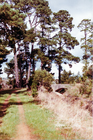
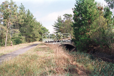
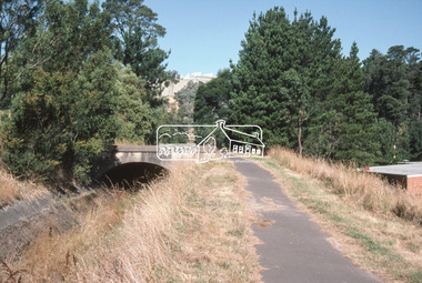
Negative - Photograph, Maroondah Aqueduct Trail near The Esplanade, Research, 1991
Looking northwest along the Maroondah Aqueduct Trail towards The Esplanade near Main Road, Research, 1991. Just after first bend from Main Road. To the left is present day (2022) Mickey's FitnessRoll of 35mm colour negative film, 9 strips Colour print 10 x 15 cmFuji HG 200 CA-1bridge, ingrams road, maroondah aqueduct, maroondah aqueduct trail, research (vic.), the esplanade -
 Greensborough Historical Society
Report, Examining Draughtsman's Report - Watts River Aqueduct, 20/07/1897
This Field Survey was commissioned by the Melbourne Board of Works and was used to position the Maroondah Aqueduct bridge north of Greensborough at its crossing point on the Plenty River. It incorporated the use of wrought iron water pipes and therefore is of lighter construction than other similar bridges in the district. It features a traverse of the Plenty RiverThe Maroondah Aqueduct bridge is a significant example of late 19th century engineering. A 4 page reproduction of an Office of Titles document. Copy of handwritten report includes maps.maroondah aqueduct, watts river aqueduct, bridge, greensborough, office of titles, 1897, wrought iron water pipes, plenty river, melbourne board of works -
 Greensborough Historical Society
Article, Anne Paul, History of Maroondah Aqueduct Pipe Bridge over the Plenty River at Greensborough, by Anne Paul, 2012_03
The Maroondah Aqueduct pipe bridge, opened in 1891, was an important part of the system carrying water from the Maroondah Reservoir near Healesville to Melbourne. Most of the original system has been replaced by stainless steel pipes, the Greensborough section now running under the Plenty River since 1977. The original pipe bridge can still be seen over the Plenty River at Greensborough.2 p. typescriptaqueduct pipe bridge greensborough, maroondah aqueduct, melbourne water supply, anne paul -
 Greensborough Historical Society
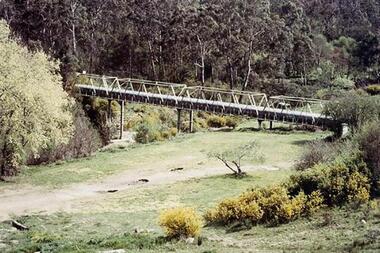
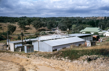
Photograph - Digital Image, Aqueduct Greensborough, 1960c
The Pipe Bridge at Greensborough is a significant and highly visible part of the system. It was constructed to carry the wrought iron aqueduct pipes over the Plenty River. The use of wrought iron meant the pipes were 75% lighter than cast iron, with the bridge construction reflecting this innovation. Photograph of the Maroondah Aqueduct pipe bridge at Greensborough. The Pipe Bridge is 210 feet long, divided into 4 spans. The main girders are light lattice 11 feet deep and 11 ft 4 inches apart. The bridge carried two wrought iron tubular mains, 53 inches in diameter, supported at intervals by cross girders and chairs, placed between the main girders. The bridge is carried on braced cast-iron columns, 18 inches in diameter, set on concrete foundations, with a clear headway of 20 feet above the Plenty River. The eastern side of the bridge is reinforced with a bluestone abutment at the river bank.Digital copy of colour photograph.maroondah aqueduct, aqueduct pipe bridge greensborough -
 Eltham District Historical Society Inc
Audio - Audio Recording, Jim Connor; Maroondah Aqueduct, 11 Jun 2022
This significant historical link in Melbourne’s water supply system is perhaps something we have taken for granted, or not even really noticed…it is just there! Built between 1886 and 1891 to transfer water from the Watts River near Healesville to the reservoir at Preston this aqueduct was 66 km in length and included open channels, tunnels and the use of inverted siphons to keep water flowing, to eventually service Melbourne and suburbs. At this meeting Jim Connor will talk about the challenges and achievements involved with this extraordinary project.1:09:10 duration Digital MP3 file; 23.7 MBaudio recording, eltham district historical society, meeting, society meeting, eltham, jim connor, maroondah aqueduct -
 Eltham District Historical Society Inc
Book, Along The Length: an account of living and working on the Maroondah Aqueduct, by Fred Sadlier, 2003c
Memoir of living and working on the Maroondah Aqueduct by former Melbourne and Metropolitan Board of Works Caretaker of Yarra Glen Lower length. The book is presented in three parts, firstly a brief explanation is given of the development of Melbourne's water supply system. Secondly the author tells in his own words his family connection with the Yarra Glen District and his work with the MBBW ca 1944-1979. The third part of the book is a tour from the Yarra Glen Lower length as it was in 2002 noting changes since Fred began working for the MMBW.iii, 34 leaves : col. ill., maps (some col.) ; 30 cm. Edited (with introduction and additional notes) by Leigh Ahern ; photographs by Gwen Sadlier and Leigh Ahern.maroondah aqueduct, water supply, yarra glen, reminscences, melbourne metropolitan board of works -
 Eltham District Historical Society Inc
Slide, Maroondah Aqueduct, Research, Victoria, 22 Mar. 1981
This view shows the area that would develop into the Research Industrial Estate. In centre distance though largely hidden by trees is the site of the Research Hall, which was later demolished and a new Eltham Little Theatre constructed in 1988 as a bicentennial project. The hills in the distance near the power lines now a housing estate.35 mm colour positive transparency (1 of 5) Mount - Agfachrome Agfa CS System black 8 dotsactivities, heritage excursion, maroondah aqueduct, research (vic.), shire of eltham historical society -
 Eltham District Historical Society Inc
Slide - Photograph, Maroondah Aqueduct, Research, c.Mar. 1989
35mm colour positive transparency (1 of 28) Mount - Kodak KodachromeProcess Date MAR 89Mmaroondah aqueduct, research (vic.) -
 Eltham District Historical Society Inc
Slide - Photograph, Maroondah Aqueduct, Research, c.Mar. 1989
35mm colour positive transparency (1 of 28) Mount - Kodak KodachromeProcess Date MAR 89Mmaroondah aqueduct, research (vic.) -
 Eltham District Historical Society Inc
Slide - Photograph, Aqueduct Bridge, Nicholas Lane, Kangaroo Ground, c.Sep. 1989
Part of a slide show presentation "Bridges & Waterways of the Shire" by Russell Yeoman to the 13 September 1989 Society meeting. The presentation included slides of historic photos from the Shire of Eltham Pioneers collections as well as several recent views.35mm colour positive transparency (1 of 15) Mount - Agfa CS System grey 8 dotskangaroo ground, aqueduct bridge, nicholas lane -
 Eltham District Historical Society Inc
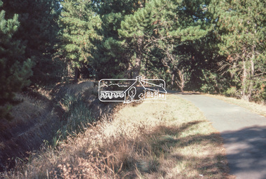
Negative - Photograph, Maroondah Aqueduct Trail, Research, 1991
Roll of 35mm colour negative film, 9 stripsFuji HG 200 CA-1maroondah aqueduct, maroondah aqueduct trail, research (vic.) -
 Eltham District Historical Society Inc
Photograph, The Maroondah Aqueduct System Old Pipe Bridge, Plenty River Walk, Greensborough, c.1989, 1989c
Colour photograph originally located in a magnetic style album titled 'Greensborough Bypass 1990s 5' suffering significant degradation. No information contained in album or on reverse of photos except where noted. Relocated to archival photosafe storage.greensborough, plenty river walk, maroondah aqueduct