Showing 174 items
matching block court
-
 Bendigo Historical Society Inc.
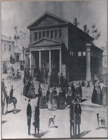
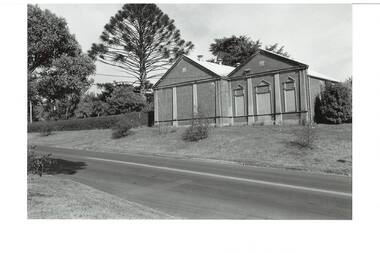
Photograph - TEMPERANCE HALL, VIEW STREET
Black and white photograph . Enlargement of illustration of original Temperance Hall, View St. Building with four column portico. Groups of people gathered in foreground (street and footpath) and LHS mid-ground (spare block). History of object: James Lerk March, 2000. Illustration of the Bendigo Temperance Hall designed' in 1860 by Vahland and Getzschmann. The Warden's Court is on the left. This section (minus the portico) is still in situ'.buildings, organisation, temperance hall -
 Bendigo Historical Society Inc.
Document - HARRY BIGGS COLLECTION: EAGLEHAWK LOGS APPEAL, 1970
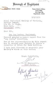
Document. Harry Biggs Collection. Item 1 - A letter with Borough of Eaglehawk letterhead to Mr H. Biggs, Royal Historical Society of Victoria Bendigo Branch, dated 9/9/1970, Re the Log Lock-up, Eaglehawk. It acknowledges a report sent to it & says a request for the Historical Society to become a committee of Trust for this building is being ascertained. Stamped with Reply affirmative11/10/70. Item 2 - a similar letter dated 18/9/1970 saying final decision will be held over. Item 3 - Instruction in letter form to Bendigo Historical Society Eaglehawk to plan & report the proposed Public Buildings Reserve Eaglehawk. Item 4 - Memorandum to Engineer's Report 17/9/1970 with recommendations for the various areas - Court House, Senior Citizens Club, Historical Society, Council Depot, Toilet Block, Occupied Land. Item 5 - Formal Engineers plan of Borough of Eaglehawk. Item 6 - Log Lock-up Appeal - list of donors.place, building, site, harry biggs collection, log lock-up appeal, eaglehawk -
 Donald History and Natural History Group operating the Donald Court House Museum
Book #2
A5 sized book bound with thin twine stitching. Block Chinese characters and images indicating parts of the body - Chinese Medicine Book.book, chinese medicine, georgie ah ling, donald, market gardener. -
 Buninyong & District Historical Society
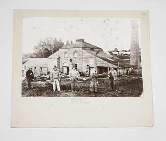
Photograph - B/W photograph, Buninyong Brewery c 1870, c1870
Photograph of an early family, the Sheppards, by their early industrial building, the brewery, in Buninyong, c1870.Significant example of early Buninyong industry, original bluestone building.Mounted B/W photograph of Buninyong Brewery c1870. Bluestone block, brick and timber building with tall round brick chimney nearby. Sheppard family in front of brewery, depicted M,M,M,F,M, with good clothing detail.buninyong brewery, brewery, buninyong, industry, building -
 Buninyong & District Historical Society
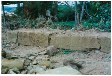
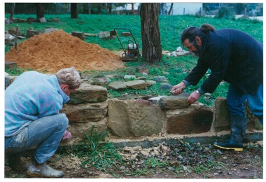
Photograph - Original Photograph, Sandstone blocks, remnants from earlier wall, 405 Learmonth Street, during reconstruction, July 1995
historic, buildingBelieved to be built using stone from Margaret Jamieson's demolished Buninyong HotelColour photo, Sandstone blocks, remnants from earlier wall, 405 Learmonth Street, during reconstruction.stone wall, learmonth st., buninyong hotel, ma jamieson -
 Buninyong & District Historical Society
Photograph - Original Photograph, Laying sandstone blocks, remnants from earlier wall, 405 Learmonth Street, during reconstruction, July 1995
historic, buildingBelieved to be built using stone from Margaret Jamieson's demolished Buninyong HotelColour photo, laying sandstone blocks, remnants from earlier wall, 405 Learmonth Street, during reconstruction.stone wall, learmonth st., buninyong hotel, ma jamieson -
 Uniting Church Archives - Synod of Victoria
Gavel sound block
Turned wood gavel sound block with engraved sliver plaque."Presented to the High Court of Victoria and Tasmania by N.S.W. Province 1950-1951"methodist order of knights -
 Robin Boyd Foundation
Slide, Robin Boyd, 1950
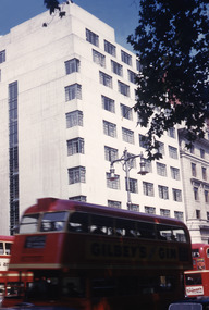
... Colour slide in a mount. Athaeneum Court, a luxury... in a mount. Athaeneum Court, a luxury apartment block on the corner ...Penleigh Boyd, Robin and Patricia Boyd's son, writes “Prior to 1950 Robin, like most other amateur or hobby photographers, took black and white printed photographs. The oldest slides date from 1950 when Robin and Patricia travelled to Europe on Robin’s Robert Haddon Travelling Scholarship.” In 1948 Robin Boyd was awarded ‘joint first place’ in the Robert Haddon competition for his design of Mildura art gallery. The scholarship helped fund their first overseas trip. Robin and Patricia were passengers on the Greek ship “Cyrenia” departing in May 1950, passing through the Suez Canal and landing in Genoa five weeks later. For six months, they travelled extensively throughout Europe (predominantly driving themselves) - France, Italy, United Kingdom, Sweden, Denmark, Germany, Austria, Switzerland and Spain.Colour slide in a mount. Athaeneum Court, a luxury apartment block on the corner of Down Street and Piccadilly, London, EnglandLondon / Piccadilly Athaeneum Court / Athaeneum (All Handwritten)haddon travelling scholarship, haddon, robin boyd, slide -
Whitehorse Historical Society Inc.
Map, Burwood Road, Box Hill City, 15/02/1952 12:00:00 AM
Plan of subdivision of ten blocks in Burwood Road, Burwood.Plan of subdivision of ten blocks in Burwood Road, Burwood between Milford Avenue and Station Street. Marked as Survey Plan No 5441.Plan of subdivision of ten blocks in Burwood Road, Burwood. land subdivision, burwood road, burwood, milford avenue, burwood, central court, burwood -
Whitehorse Historical Society Inc.
Document, Fulton Park Estate, 1970s
Real estate brochure for the sale of 49 blocks at Fulton Park Estate Blackburn South.Real estate brochure for the sale of 49 blocks at Fulton Park Estate Blackburn South. Agents: E Flintoff & Sons and K F LangReal estate brochure for the sale of 49 blocks at Fulton Park Estate Blackburn South. fulton road, blackburn south, freda court, blackburn south, lucia street, blackburn south, mira street, blackburn south, lana street, blackburn south, residential development, fulton park estate -
Whitehorse Historical Society Inc.
Document, Municipal Reserve, n.d
Hand drawn map of blocks and municipal reserve off Anjaya Court, Blackburn.parks and reserves, anjaya court, blackburn -
Ballarat Heritage Services
digital copy, Ballarat East High School Magazine 1960, 1960
School History: In February, 1955, Ballarat East High School opened in Hopetoun Street, in the vacated weatherboard buildings of the Girls’ Secondary School. In 1956, however, the School moved to its present site in Fussell Street, but because of the lack of space, Woodwork and Cookery classes were still held at Hopetoun Street. Since then there has been steady progress. The original building was extended, more classrooms and a library being built. A Domestic Science block was completed in 1957. Later, as mentioned elsewhere, sheltersheds, basketball courts, a bidycle shed and a canteen were provided for the pupils from funds raised by the Parents’ Association. Where there were previously bare areas of clayey soil we now have asphalt paths and neat gardens. Shrubs were planted, and seats, painted in the School colours, were places around the asphalted areas. (Page 5, 1959 BEHS School Magazine) 3 pdf files containing multiple pages of the BEHS 1960 School Magazinebehs, ballarat east high school, ballarat east, magazine, 1960 -
Ballarat Heritage Services
digital copy, Ballarat East High School Magazine 1961, 1961
School History: In February, 1955, Ballarat East High School opened in Hopetoun Street, in the vacated weatherboard buildings of the Girls’ Secondary School. In 1956, however, the School moved to its present site in Fussell Street, but because of the lack of space, Woodwork and Cookery classes were still held at Hopetoun Street. Since then there has been steady progress. The original building was extended, more classrooms and a library being built. A Domestic Science block was completed in 1957. Later, as mentioned elsewhere, sheltersheds, basketball courts, a bidycle shed and a canteen were provided for the pupils from funds raised by the Parents’ Association. Where there were previously bare areas of clayey soil we now have asphalt paths and neat gardens. Shrubs were planted, and seats, painted in the School colours, were places around the asphalted areas. (Page 5, 1959 BEHS School Magazine) 3 pdf files of multiple pages of BEHS School magazine=1961 behs, ballarat east high school, ballarat east, magazine, 1961 -
Ballarat Heritage Services
digital copy, Ballarat East High School Magazine 1962
School History: In February, 1955, Ballarat East High School opened in Hopetoun Street, in the vacated weatherboard buildings of the Girls’ Secondary School. In 1956, however, the School moved to its present site in Fussell Street, but because of the lack of space, Woodwork and Cookery classes were still held at Hopetoun Street. Since then there has been steady progress. The original building was extended, more classrooms and a library being built. A Domestic Science block was completed in 1957. Later, as mentioned elsewhere, sheltersheds, basketball courts, a bidycle shed and a canteen were provided for the pupils from funds raised by the Parents’ Association. Where there were previously bare areas of clayey soil we now have asphalt paths and neat gardens. Shrubs were planted, and seats, painted in the School colours, were places around the asphalted areas. (Page 5, 1959 BEHS School Magazine)4 pdf files holding multiple pages of BEHS 1962 School Magazines. These are large pdf files being each around 20MB or largerbehs, ballarat east high school, ballarat east, magazine, 1962 -
 Wangaratta High School
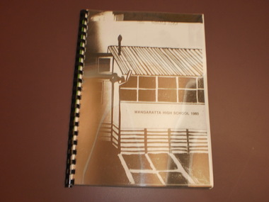
WHS Yearbook -Korrumbeia, 1980
Black and white bound photocopy of the 1980 yearbook with a full page drawing of an A-block school building, with painted downball courts out the front. Written on the wall in black text is WANGARATTA HIGH SCHOOL 1980WANGARATTA HIGH SCHOOL 1980 -
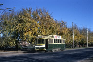 Ballarat Tramway Museum
Slide - 35mm slide/s - set of 14, Noel Simons, 22/05/1971 12:00:00 AM
Set of 14 transparencies taken on 22/5/1971. 1170.1 - No. 31 outbound in Sturt St. West near Murray St. - has "To read pack Tilt Train" roof advert. 1170.2 - No. 31 ditto, near Russel St. loop. 1170.3 - No. 14 in Wendouree Parade at what is now BTM Depot Junction, near Toilet block. 1170.4 - No. 31 in Wendouree Parade at the North Gardens, approaching St. Aidans Drive 1170.5 - Scrubber car on "O " road with tennis court alongside. 1170.6 - Scrubber, 43 and 3 8 on 0 road at depot. 1170.7 - 3 8 and 43 on 0 road at depot 1170.8 - 38 on 0 road at depot, showing sharpness of 0 road curves. 1170.9 - 39 and 40 inside depot. 40 has "To read pack, tilt tram" roof advertisement. 1170. 10 - Tram 27 passes the depot gates, east bound with Lake Wendouree in the background. 1170.11 - SEC Depot, from Wendouree Parade, with No. 38 on "O" road. 1170.12 - trams 14 and 30 at depot loop, Wendouree Parade 1170.13 - ditto 1170.14 - "Cars take following line" sign on tram stop pole at Wendouree Parade Loop. All have date stamp of "28 Apr 1971" in purple ink on base. All blue ink unless otherwise noted. 1170.1 - "No. 31 in Sturt St. West between Murray and Wonliss Sts." 1170.2 - "No. 31 approaching Russell St. Loop in Sturt St. West Ballarat" 1170.3 - "No. 14 Gardens" 1170.4 - "No. 3 1 North Gardens 1170.5 - "Track cleaner car (formerly No. 23) at Wendouree Depot" 1170.6 - "Track cleaner, No. 43 and No. 38 at Wendouree Depot" 1170.7 - "No. 43 and No. 38 at Wendouree Depot" 1170.8 - "No. 38 gazes across Lake Wendouree from depot" 1170.9 - "Nos 3 9 and 40 in Wendouree Depot" 1170.10 - "No. 27 passing Wendouree Depot" 1170.11 - "Wendouree Depot with No. 38 on road No. "O" on left. 1170.12 - "Depot Loop" 1170.13 - "Depot Loop" 1170.14 - "Depot" tramways, trams, sturt st. west, wendouree parade, o road, depot, depot loop, signs, bliss bombs, tram 14, tram 27, tram 30, tram 31, tram 38, tram 39, tram 40, tram 43, tram scrubber -
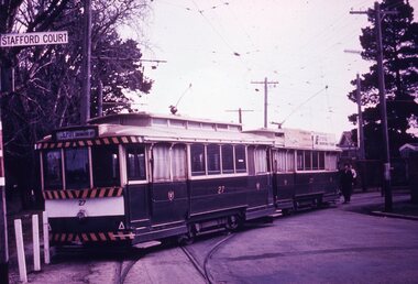 Ballarat Tramway Museum
Slide - 35mm slide/s - set of 7, Noel Simons, 1970's
Set of 7 transparencies taken undated (appear to be 1970 or 71) on PAKON mounts. Also possibly copy slides as quality is poorish. 1175.1 - No. 27 has derailed at Depot, across Wendouree Parade, and No. 33 appears to be about to try and tow it back on. Wendouree Parade totally blocked. Adjacent pole has tram stop sign and has "Stafford Court" street sign mounted on it. 1175.2 - No. 43 at corner of Drummond St. South and Dana Street, with destination Lydiard St. North. 1175.3 - No. 42 (Mt Pleasant) and 21 (Gardens via Sturt St. West) crossing at Gardens Loop. 1175.4 - No. 42 bound for Lydiard St. Nth at intersection with Macarthur St. Shows the retaining wall for the cutting on the east side of Lydiard St. Nth. 1175.5 - No. 43 at corner of Lydiard St and Sturt St., at city terminus showing "Special" and tram 35 adjacent to Post Office in Lydiard St. Nth. Photo shows the small tram stop pole at this location and Post Office building. 1175.6 - No. 39 and 26 and 27 at the Mt Pleasant terminus. Near closure as a bus stop sign has been positioned on the west side of the road. No. 39 showing destination of "Gardens via Sturt St. West" 1175.7 - Nos 21 and 34 crossing at the Grant St. loop in Barkly St. 21 has destination of Mt Pleasant, while 34, - Gardens via Sturt St. West"All information on typed small white labels, on the top of the slides using black ink. 1175.1 - "27 derailed and 33 at depot" 1175.2 - "43 at cnr Drummond & Dana Sts" 1175.3 - "21 and 42 Gardens Terminus" 1175.4 - "42 at cnr Macarthur & Lydiard" 1175.5 - "43 & 35 at Post Office" 1175.6 - "39, 26 and 27 at Mt Pleasant" 1175.7 - "21 & 34 at Grant St"tramways, trams, wendouree parade, depot, accidents, derailments, drummond st. sth, gardens loop, post office, mt pleasant, grant st., tram 21, tram 26, tram 27, tram 33, tram 35, tram 42, tram 43 -
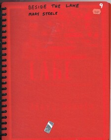 Ballarat Tramway Museum
Document - Folder with papers, Mary Steele, "Beside the Lake", c2000
Photocopy - 24 sheets from a book contained within a red cover multi sheet folder - titled "Beside the Lake", written by Mary Steele, the daughter of the 5th Bishop of Ballarat writing about her memories living in Bishops court Ballarat from 1936. Not all pages copied. Has notes on the lake, Sturt St, the building, Lake Wendouree, a plan of the house block, the garden. Published by Hyland House - 2000 - Trove notes it as 246 pages. Bookmark as at 19-8-2016 - http://trove.nla.gov.au/work/6790878 trams, tramways, anglican church, lake wendouree, ballarat, bishops court -
Bendigo Historical Society Inc.
Plan - SANDHURST BOYS CENTRE COLLECTION: PART DETAIL SURVEY
Prepared by the Public Works Department for the Government of Victoria. Client is the Mental Health Department, Municipality is City of Bendigo. Site plan of area bounded by O'Dwyer St and Finn St, North Bendigo. Handwritten note on back - Update of whole centre 10/4/91. Details include: oval, tennis court, grandstand, area is bounded by an un-named watercourse. Also indicated are 14 nissen huts, 2 toilet blocks, 3 weatherboard buildings, 1 galvanised iron building,2 galvanised iron sheds (one new), residence, garage, fowl shed, and a carpark. Location unknown 16.02.2023.bendigo, institutions, sandhurst boys centre, sandhurst boys centre site plan; -
 Bayside Gallery - Bayside City Council Art & Heritage Collection
Work on paper - ink and watercolour, Annette Meikle, Sandringham Club, 1977
In 1977, artist Annette Meikle undertook a commission to illustrate a book recording stories of places and people in the Bayside area. It was published in 1978 as Sandringham Sketchbook, with text by Elizabeth Waters. The sketches were intended to record remaining examples of Bayside’s early architecture and environment, as well as reflect newer architectural changes. Meikle went on to donate 22 of these sketches to Bayside City Council in 2003. In the mid 1870s wealthy solicitor David Abbot bought a large block on the corner of Bamfield Street and Beach Road and built an imposing family home with a stately tower. It featured rare Hawthorn Blacks – hand-made bricks of brown-red with streaks of charcoal black. For many years the home was the most prominent in the district. In 1922 ‘Coggeshall’ was subdivided, and the house was sold to the Sandringham Club, a gentleman’s club that had formed in 1913 and required more space for its growing membership. Members enjoyed lawn tennis courts, a bowling green and a cricket green, as well as a large billiard room. The Sandringham Club still owns ‘Coggeshall’.Annette Meikle, Sandringham Club 1977, ink and watercolour, 25.7 x 35.7 cm. Bayside City Council Art and Heritage Collection. Donated by the artist, 2003annette meikle, sandringham sketchbook, elizabeth waters, sandringham, sandringham club, gentleman’s club, coggeshall, david abbot, historic house -
 Buninyong & District Historical Society
Photograph - B/W photograph, Buninyong Masonic Lodge, 1993
The Buninyong Masonic Lodge was originaly formed in 1858. This brick building is the second hall on the site.Third oldest Masonic Lodge in Ballarat area, example of C20th public building.Black and White photograph of the Buninyong Masonic Lodge, double-fronted brick building, decorative concrete low-relief pillars, door and windows blocked. Also showing nature strip and roadway in Warrenheip Streetbuninyong, warrenheip st., masons., hall, building, streetscape -
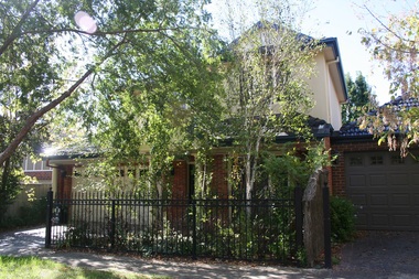
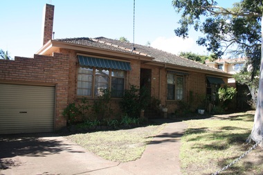
 Surrey Hills Historical Society Collection
Photograph - 1 Hotham Court, Mont Albert, On The Street Where You Live Project
Photos documenting this address as part of a photographic series undertaken by volunteer photographers during 2013 and 2014 for The Street Where You Live Project. This was organised through the Surrey Hills Neighbourhood Centre and covered the postcode 3127 in the cities of Boroondara and Whitehorse.These photos provide a snapshot of real estate in the suburbs of Mont Albert and Surrey Hills during a period of rapid change with many properties on large blocks demolished to create higher density residential development or renewal of single dwellings. At particular risk were properties not covered by heritage overlays, especially interwar housing and post 1950's housing. -
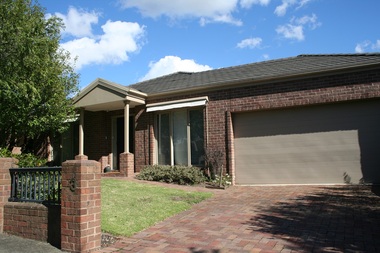
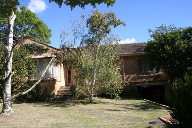
 Surrey Hills Historical Society Collection
Photograph - 2 Hotham Court, Mont Albert, On The Street Where You Live Project
Photos documenting this address as part of a photographic series undertaken by volunteer photographers during 2013 and 2014 for The Street Where You Live Project. This was organised through the Surrey Hills Neighbourhood Centre and covered the postcode 3127 in the cities of Boroondara and Whitehorse.These photos provide a snapshot of real estate in the suburbs of Mont Albert and Surrey Hills during a period of rapid change with many properties on large blocks demolished to create higher density residential development or renewal of single dwellings. At particular risk were properties not covered by heritage overlays, especially interwar housing and post 1950's housing. -
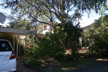
 Surrey Hills Historical Society Collection
Photograph - 2A Hotham Court, Mont Albert, On The Street Where You Live Project
Photos documenting this address as part of a photographic series undertaken by volunteer photographers during 2013 and 2014 for The Street Where You Live Project. This was organised through the Surrey Hills Neighbourhood Centre and covered the postcode 3127 in the cities of Boroondara and Whitehorse.These photos provide a snapshot of real estate in the suburbs of Mont Albert and Surrey Hills during a period of rapid change with many properties on large blocks demolished to create higher density residential development or renewal of single dwellings. At particular risk were properties not covered by heritage overlays, especially interwar housing and post 1950's housing. -
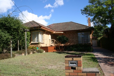
 Surrey Hills Historical Society Collection
Photograph - 2B Hotham Court, Mont Albert, On The Street Where You Live Project
Photos documenting this address as part of a photographic series undertaken by volunteer photographers during 2013 and 2014 for The Street Where You Live Project. This was organised through the Surrey Hills Neighbourhood Centre and covered the postcode 3127 in the cities of Boroondara and Whitehorse.These photos provide a snapshot of real estate in the suburbs of Mont Albert and Surrey Hills during a period of rapid change with many properties on large blocks demolished to create higher density residential development or renewal of single dwellings. At particular risk were properties not covered by heritage overlays, especially interwar housing and post 1950's housing. -
 Surrey Hills Historical Society Collection
Photograph - 3 Hotham Court, Mont Albert, On The Street Where You Live Project
Photos documenting this address as part of a photographic series undertaken by volunteer photographers during 2013 and 2014 for The Street Where You Live Project. This was organised through the Surrey Hills Neighbourhood Centre and covered the postcode 3127 in the cities of Boroondara and Whitehorse.These photos provide a snapshot of real estate in the suburbs of Mont Albert and Surrey Hills during a period of rapid change with many properties on large blocks demolished to create higher density residential development or renewal of single dwellings. At particular risk were properties not covered by heritage overlays, especially interwar housing and post 1950's housing. -
 Surrey Hills Historical Society Collection
Photograph - 4 Hotham Court, Mont Albert, On The Street Where You Live Project
Photos documenting this address as part of a photographic series undertaken by volunteer photographers during 2013 and 2014 for The Street Where You Live Project. This was organised through the Surrey Hills Neighbourhood Centre and covered the postcode 3127 in the cities of Boroondara and Whitehorse.These photos provide a snapshot of real estate in the suburbs of Mont Albert and Surrey Hills during a period of rapid change with many properties on large blocks demolished to create higher density residential development or renewal of single dwellings. At particular risk were properties not covered by heritage overlays, especially interwar housing and post 1950's housing. -
 Surrey Hills Historical Society Collection
Photograph - 5 Hotham Court, Mont Albert, On The Street Where You Live Project
Photos documenting this address as part of a photographic series undertaken by volunteer photographers during 2013 and 2014 for The Street Where You Live Project. This was organised through the Surrey Hills Neighbourhood Centre and covered the postcode 3127 in the cities of Boroondara and Whitehorse.These photos provide a snapshot of real estate in the suburbs of Mont Albert and Surrey Hills during a period of rapid change with many properties on large blocks demolished to create higher density residential development or renewal of single dwellings. At particular risk were properties not covered by heritage overlays, especially interwar housing and post 1950's housing. -
 Surrey Hills Historical Society Collection
Photograph - 6 Hotham Court, Mont Albert, On The Street Where You Live Project
Photos documenting this address as part of a photographic series undertaken by volunteer photographers during 2013 and 2014 for The Street Where You Live Project. This was organised through the Surrey Hills Neighbourhood Centre and covered the postcode 3127 in the cities of Boroondara and Whitehorse.These photos provide a snapshot of real estate in the suburbs of Mont Albert and Surrey Hills during a period of rapid change with many properties on large blocks demolished to create higher density residential development or renewal of single dwellings. At particular risk were properties not covered by heritage overlays, especially interwar housing and post 1950's housing. -
 Surrey Hills Historical Society Collection
Photograph - 7 Hotham Court, Mont Albert, On The Street Where You Live Project
Photos documenting this address as part of a photographic series undertaken by volunteer photographers during 2013 and 2014 for The Street Where You Live Project. This was organised through the Surrey Hills Neighbourhood Centre and covered the postcode 3127 in the cities of Boroondara and Whitehorse.These photos provide a snapshot of real estate in the suburbs of Mont Albert and Surrey Hills during a period of rapid change with many properties on large blocks demolished to create higher density residential development or renewal of single dwellings. At particular risk were properties not covered by heritage overlays, especially interwar housing and post 1950's housing.