Showing 1057 items matching "boundaries"
-
 Port Melbourne Historical & Preservation Society
Plan - Evans Street from ingles Street to Boundary Street, 1893 - 1919
Plan of Evans Street from Ingles Street to Boundary Street 1893..engineering - roads streets lanes and footpaths -
Port Melbourne Historical & Preservation Society
Plan - Boundary Street from Quinn Street to Evans Street, Engineering Department, Town of Port Melbourne, 1893 - 1919
Plan of Boundary Street from Quinn Street to Evans Street 1893.engineering - roads streets lanes and footpaths -
Tatura Irrigation & Wartime Camps Museum
Document, Geological Plan, Eildon Dam Site, 1945
To record details of geological aspects of EildonA series of maps illustrating rock formations etc., locations, boundaries and planswater/irrigation, documents, maps -
Whitehorse Historical Society Inc.
Map, Proposed suburb names, 1999
Whitehorse City Council: proposed suburb names and boundaries. Version 3.1Whitehorse City Council: proposed suburb names and boundaries. Version 3.1Whitehorse City Council: proposed suburb names and boundaries. Version 3.1city of whitehorse, suburb names -
 Bendigo Historical Society Inc.
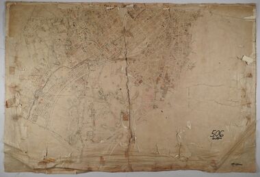
Map - SANDHURST (PART), No date visible
Map: Parish plan showing the Southwestern corner of Sandhurst to the Municipal boundarymap, bendigo, parish plan, sandhurst -
 Bendigo Historical Society Inc.
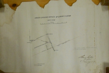
Plan - MARKS COLLECTION: UNDERGROUND SURVEY MR. DENNIS CLAIM NEW CHUM
Plan on heavy parchment paper. On top of plan 'underground survey Mr. Dennis, New Chum' Signed: Thomas Forbes, Surveyor, 11th. January 1867. shows surface boundary of Dennis and Bonati. Written in blue pencil 'From nail in sapling 33f. 51/2 to boundary. Online to drill hole' Shaft marked on LH boundary.'bendigo, mining, mr. dennis claim, new chum -
 Federation University Historical Collection
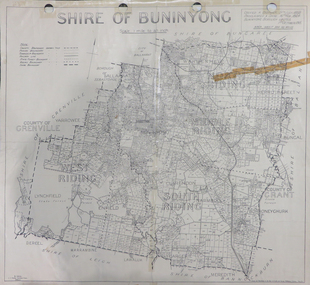
Map, Shire of Buninyong, c1970
The Shire of Buninyong was located on the southern side of Ballarat.Two maps of the Shire of Buninyong. .1) Map showing the County divisions, township boundaries, Railway line, State Forest boundary, riding boundary and shire boundary. Identifying words have been added in red and green texta. .2) Shire of Buninyong Parish Plan. Includes Buninyong, Clarendon, Narmbool, Enfield, Lychfield, SCotchman's, Navigators, Warrenheip, Scotsburn, mr Doran, Durham Lead, Cambrian Hill, Napoleons, Garibaldi, Mt Clear, Lal Lal, Bonshaw.1) B.I.A.E., St Martin's, cemetery, mt Buninyong, mt Innes, rly stn shire of buninyong, buninyong, clarendon, narmbool, enfield, lychfield, scotchman's, navigators, warrenheip, scotsburn, mt doran, durham lead, cambrian hill, napoleons, garibaldi, mt clear, lal lal, bonshaw, state forest, elaine, elaine north, cargerie, grenville, mt mercer, millbrook, wallace, yendon, canadian, kaolin deposits, mount helen campus -
 Greensborough Historical Society
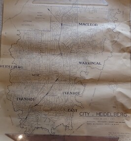
Map, City of Heidelberg. Engineers Dept, City of Heidelberg, 1960s
Map of the City of Heidelberg from the Yarra River in the South to North of Watsonia Military Camp. Shire of Diamond Valley is shown to the north.Map showing municipal and ward boundaries, black text on light brown paper."Scale: 20 CHS = to 1 IN"city of heidelberg -
Whitehorse Historical Society Inc.
Pamphlet, Your City 1971, 1971
Brief compendium of information about the city with names of councilors, ward boundaries etcBrief compendium of information about the city with names of councilors, ward boundaries etcBrief compendium of information about the city with names of councilors, ward boundaries etccity of nunawading, ward boundaries -
 Whitehorse Historical Society Inc.
Photograph, Quarry Road Mitcham, 2006
Coloured photo of Guarry Road bridge near boundary of Whitehorse and Manningham municipalities.quarry road, mitcham, bridges -
 Port Melbourne Historical & Preservation Society
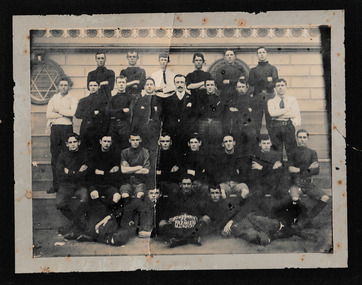
Photograph - Boundary Football Club 1907, 1907
Sepia photograph of Boundary Football Club 1907 Premier's Team. Players and officials are in 4 rows with the players in the centre front row holding an Australian Rules football inscribed 'Boundary F.C. Premiers M.J. 1907. F.A".sport - australian rules football, boundary football club -
 Lara RSL Sub Branch
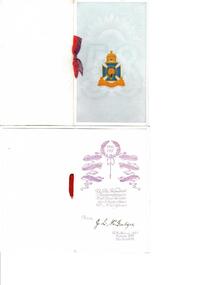
Card, Christmas Card, 1916
The cards where distributed army personal to send home from the war. J.I. McIntyre was a member of the Lara RSL along with brothers Jim and Thonas Blue Card with white boundary, with card insert and red ribbon tying them together On the front page 58th Battalion Badge. Inside 1916-1917 inside a wreath of wheat .Going down on either side in a scroll like pattern is the names of battles on the left is Somme, Fromelles Sinai and on the right is Lagnicourt, Bullecourt, Polygon Wood. In the middle is written in script With Kindness Remembrances & all Good A.I.FWishes for Christmas & New Year From J.L McIntyre. Down the bottom is 58th Battalion A.I.F Xmas 1917 New Year 1918 christmas card, world war one, army, a.i.f, mcintyre -
Port Melbourne Historical & Preservation Society
Plan - Evans Street from Ingles Street to Boundary Street, Engineering Department, Town of Port Melbourne, 1893 - 1919
Plan of Evans Street from Ingles Street to Boundary Street Loan no 5 1893.engineering - roads streets lanes and footpaths -
 Victorian Aboriginal Corporation for Languages
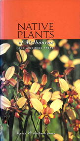
Book, David Jones et al, Native plants of Melbourne and adjoining areas : a field guide, 1999
A simple guide to the Indigenous plants of the Melbourne region. The extent of the boundaries of this region is outlined in the introduction.Colour photographs, glossarynative plants, melbourne, identification -
 St Patrick's Old Collegians Association (SPOCA)
Photograph - SPOCA, Patricians FC
-
Port Melbourne Historical & Preservation Society
Photograph - Boundary Rovers Football Team, 1946
Boundary Rovers Football team (Rising Sun Hotel) 1946, with names of players and officialssport - australian rules football, rising sun hotel, vic butler, mccaulley dowdle, bonnie stewart, tom brosnan, clarrie bulpit, harrison, len mccaulley, dick mccaulley, jack pope, jack dobson, jack love, jim coy, jack o'shannessey, gerald beaton, woes marshal, norm gent, copy keeting, ernie davis, bob allan, stan bulpit, bert francis, alf harrison, arthur marini, charlie mccaulley, a 'nappy' ollington, frank henry, les williams, boundary rovers football club, business and traders - hotels -
Port Melbourne Historical & Preservation Society
Document - Voter Rolls, City of Port Melbourne, Port Melbourne City Council, 1940s - 1970s
Seven Voter lists, City of Port Melbourne. Boundary Ward, 1951. Centre ward 1951. Centre ward 1975. Sandridge ward 1963. Boundary Ward 1963. Sandridge ward 1963. All wards late 1940s to early 1950slocal government - city of port melbourne -
Federation University Historical Collection
Plan, Shire of Buninyong Warrenheip water supply general management
The Shire of Buninyong was later amalgamated into the City of Ballarat.Map shows the 1966 district boundaries of Ballarat and the layout of properties and water pipes in Warrenheip 1966.Gutteridge, Haskins & Davey Consulting Engineers Shire of Buninyong Warrenheip water supply general management September 1966buninyong, vincent, warrenheip, gutteridge, haskins & davey, water supply -
 Port Melbourne Historical & Preservation Society
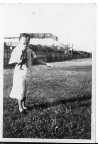
Photograph - Fred Nicholson and his mother, bridge over railway at Boundary Street, Port Melbourne, 1938
Photo showing bridge over railway at Boundary St. Fred Nicholson and his mother, 1938.families, engineering - roads streets lanes and footpaths, fred nicholson, boundary street -
Whitehorse Historical Society Inc.
Document, Removal of Trees, 2016
The fate of backyard trees bordering the rail line boundary in Blackburn may rest in the hands of the residents.The fate of backyard trees bordering the rail line boundary in Blackburn may rest in the hands of the residents.The fate of backyard trees bordering the rail line boundary in Blackburn may rest in the hands of the residents.blackburn, level crossing removal authority, trees -
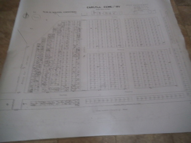
 Rutherglen Historical Society
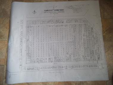
Carlyle Cemetery Map, Plan of Presbyterian Compartment, 1952
This is a map produced to attempt to bring order to the cemetery. Originally the layout was not well defined and it is difficult to use this plan to locate a particular grave, also the fact that not all graves are marked and foot paths are not defined has exacerbated this issue. Photocopy, White paper, black printing, black line work showing lot and compartment boundariesReferences Grid Survey points at 50 feet centres shown (as a cross with the reference mark number in brackets) Lot Number shown at left side of graves. Burial Number shown at right side of grave. Lots with unidentified burials show with dashed cross with in the lot. topographic survey, cadastral survey, carlyle cemetery, burials, graves, lot boundary, rotunda -
 Rutherglen Historical Society
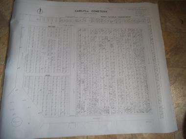
Carlyle Cemetery Map, Plan of Roman Catholic Compartment, 1952
This is a map produced to attempt to bring order to the cemetery. Originally the layout was not well defined and it is difficult to use this plan to locate a particular grave, also the fact that not all graves are marked and foot paths are not defined has exacerbated this issue. Photocopy, White paper, black printing, black line work showing lot and compartment boundariesReferences Grid Survey points at 50 feet centres shown (as a cross with the reference mark number in brackets) Lot Number shown at left side of graves. Burial Number shown at right side of grave. Lots with unidentified burials show with dashed cross with in the lot. topographic survey, cadastral survey, carlyle cemetery, burials, graves, lot boundary, rotunda -
 Rutherglen Historical Society
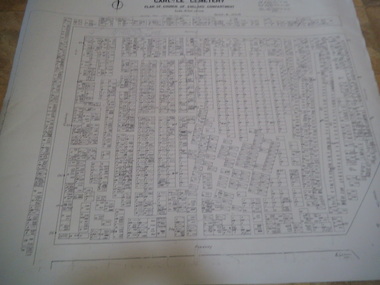
Carlyle Cemetery Map, Plan of Church of England Compartment, 1952
This is a map produced to attempt to bring order to the cemetery. Originally the layout was not well defined and it is difficult to use this plan to locate a particular grave, also the fact that not all graves are marked and foot paths are not defined has exacerbated this issue. Photocopy, White paper, black printing, black line work showing lot and compartment boundariesReferences Grid Survey points at 50 feet centres shown (as a cross with the reference mark number in brackets) Lot Number shown at left side of graves. Burial Number shown at right side of grave. Lots with unidentified burials show with dashed cross with in the lot. topographic survey, cadastral survey, carlyle cemetery, burials, graves, lot boundary, rotunda -
 Rutherglen Historical Society
Carlyle Cemetery Map, Plan of Wesleyan Compartment, 1952
This is a map produced to attempt to bring order to the cemetery. Originally the layout was not well defined and it is difficult to use this plan to locate a particular grave, also the fact that not all graves are marked and foot paths are not defined has exacerbated this issue. Photocopy, White paper, black printing, black line work showing lot and compartment boundariesReferences Grid Survey points at 50 feet centres shown (as a cross with the reference mark number in brackets) Lot Number shown at left side of graves. Burial Number shown at right side of grave. Lots with unidentified burials show with dashed cross with in the lot. topographic survey, cadastral survey, carlyle cemetery, burials, graves, lot boundary, rotunda -
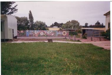 Buninyong & District Historical Society
Photograph - Colour photograph, Colour photograph of the rear Yendon Primary School 1994 featuring the playground area and mural
Yendon Primary School operated as a State School from 1877 and ceased operating in 1993. The School initially operated as the Buninyong East Common School from 1864.The children of railway workers from the Ballarat- Geelong railway would have formed much of the opening enrolment of the school.Colour photograph showing the rear of the former of Yendon Primary featuring the playground and mural on the boundary fence.Yendon Primary School 1994education, yendon, state schools -
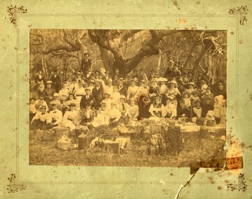 Orbost & District Historical Society
Photograph - Picnic at Old Station, Orbost
The Old Station Homestead site at Corringle Beach was a popular destination for Orbost people to have picnics late 19Century. They would travel out in buggies from Orbost or Newmerella with food hampers, have a picnic, play games etc. This location was always referred to as the Old Station because it had been one of the earliest Stations in this district in the early days of European settlement. evidence of recreation, entertainment in the Orbost districtA sepia coloured photograph pasted onto grey cardboard. Photo shows a group of people standing and sitting under trees with picnic baskets and hampers in the foreground. Many people wear hats. On back of photograph: Mrs Reynolds Senr, 72 Boundary Road. Old Station Beach, Orbost orbost, corringle, old station homestead site, picnic -
Port Melbourne Historical & Preservation Society
Photograph - Towers, J Kitchen & Sons site, Boundary Street, Port Melbourne, 1960s
Black and white photo on foam board. Towers at Kitchen's site. Two clusters of towers on Boundary Stindustry, manufacturing, j kitchen & sons pty ltd, pental products pty ltd, symex holdings ltd, boundary road -
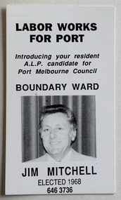 Port Melbourne Historical & Preservation Society
Card - City of Port Melbourne, council election, Jim MITCHELL, 1970s
Election card for Jim MITCHELL, representative for Boundary Ward, for Port Melbourne City Council, c. 1970sName and address handwritten by Jim Mitchell on reverse side.politics, local government - city of port melbourne, societies clubs unions and other organisations, james malcolm (jim) mitchell, australian labor party -
Bendigo Historical Society Inc.
Document - MARKS COLLECTION: PLAN OF MR. DENNIS'S MINE, NEW CHUM REEF
Mine plan drawn on heavy parchment paper. On top of plan 'Plan of workings for Mr. Dennis' Mine, New Chum Reef' Names on plan : Boundary line Koch & Hildebrandt; boundary line Bonati & Co. Signed on bottom (signature not clear) 14/9/72. -
Port Melbourne Historical & Preservation Society
Document - Electoral Roll, City of Port Melbourne, Boundary Ward, City of Port Melbourne, Voters' Rolls, 1983
Prepared by the Town clerk's office. Voters Roll for City of Port Melbourne's Boundary Ward: list of electors entitled to be enrolled on Municipal Clerk's rolls.Voters' Rolls 1983/84 City of Port Melbourne, Electoral Province of Melbourne, Port Melbourne Division Sandridge Ward - List of electors entitled to be enrolled on Municipal Clerks' Rolls @ 29 July 1983.local government - city of port melbourne, town clerks, frederick charles jackson