Showing 297 items
matching brick shops
-
 Eltham District Historical Society Inc
Slide, Joh Ebeli, Preserving parts of the old Baker's house, corner of York Street and Main Road, Eltham, c.Sep. 1979
The old weatherboard building, possibly dating from the 1860s, comprised a dwelling with a shop in the front room opening off a timber verandah deck which directly fronted the Main Road footpath. At the rear is a brick building of much later date which was for many years used for the bakery. The buildings were demolished for flat construction. Joh Ebeli and Elwers Howard endeavoured to preserve some parts of the house.35 mm colour positive transparency Mount - Agfachrome Professional black (Germany) 4 dotsmain road, old eltham bakery, york street -
 Federation University Historical Collection
Pamphlet, Jeff Zilles, Old Curiosity Shop, c1980s
The Old Curiosity Shop was q house was built by bricklayer James Warwick, and his wife Caroline, with construction beginning around 1863. It was opened to the public in 1895. What is significant? Construction of the house later known as the Old Curiosity Shop commenced about 1863, the year bricklayer, James Warwick obtained a miner's right for a residential block on the edge of the exhausted Eureka diggings in the newly proclaimed municipality of Ballarat East. James built a modest 4-roomed timber and brick house for his expanding family and continued in the bricklaying trade until retiring around the early 1880s. By then he was pursuing his gardening interests in the local Horticultural Society and was supervising the gardens of many East Ballarat residents. It was during these years that his gardening and building interests converged to find expression in the marvellous permutations of decoration that extend over the house and garden. Using cast-off crockery, glass, ceramic figurine and mirror shards, shells, wallpaper samples, architectural ornament and slag, a place was found for all manner of things, large and small. Children would bring broken china dolls and bits of crockery, and the patient mosaic work preoccupied James and his wife Caroline for the rest of their lives. The work has its origins in the grottoes and shellhouses that ornamented the gardens of large English estates from the 1730s. In the few years before James' death in 1898, the house had become known as the 'Old Curiosity Shop', inspiring associations with the Charles Dickens novel of the same name. By then professional photographs had also been taken and thousands of tourists were visiting it yearly. Caroline obtained copyright for 2 of the photos and began issuing her own postcards before she died in 1903. The Shop passed to their son Charles and then to a succession of owners who added their own mythology to the story of the Warwicks and their work. After attracting tourists for more than 100 years, the Shop closed to the public in 1999. (Vitorian Heritage Database)Brochures on the Old Curiosity Shopold curiosity shop, warwick, ballarat east, james warwick, caroline warwick -
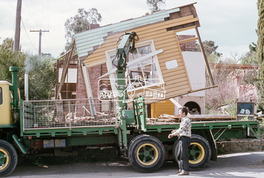
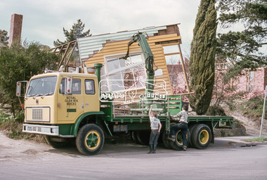
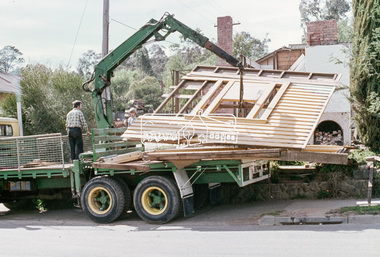
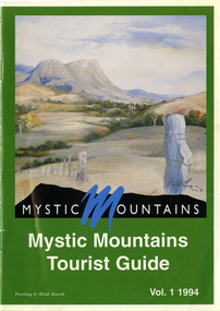 Marysville & District Historical Society
Ephemera (Item) - Tourist Guide, Michael Nash et al, Mystic Mountains Tourist Guide Vol. 1 1994, 1994
A tourist guide outlining services, accommodation, activities and places of interest to visit in and around Marysville and the local district.A tourist guide outlining services, accommodation, activities and places of interest to visit in and around Marysville and the local district.ACKNOWLEDGEMENTS:/ Marysville and District Tourist and Progress Association, Marysville/ Office of the Department of Conservation & Natural Resources, Shire/ of Alexandra Visitors Guide and all our advertisers whom without/ their support this publication would not have been possible.marysville, victoria, australia, tourist guide, mystic mountains, michael nash, dudley jones, marysville and district tourist and progress association, department of conservation & natural resources, shire of alexandra, paperwork professionals, pp art services, harrier printing, darrowby deer farm, heidi boesch, hidden talent craft gallery, olde yarra track shoppe, lady talbot forest drive, mathilde's of marysville country guest house, wishing well, taggerty river picnic area, taggery river, phantom falls, keppel falls, the beeches walking track, mount sugarloaf, beauty spot walk, tree fern gully walk, michaeldene track, keppel track, woods lookout track, marysville caravan park, baree mud brick cottages, cumberland scenic reserve, nanda binya lodge, cambarville, the big tree, barton's lookout, cumberland falls, our lady of the snows catholic church, anglican church christ, marysville christian fellowship, sovereign view, the big culvert, st fillan, steavenson's restaurant, the birches resort, cathedral range state park, tower motel, marysville post shop, lake mountain, wirreanda festival, cross country ski hire, marysville hotel motel, kerami house, marysville holiday cottages, missing links miniature golf, top shop pancake parlour, marylands guest house, dalrymples guest cottages, crossways country inn, esa camping & conference centre, scenic motel, the cumberland, maryton park holiday cottages, lomatia lodge holiday house, willowbank gallery and art centre, igloo roadhouse, a model tours, geoffrey pope & associates -
 Marysville & District Historical Society
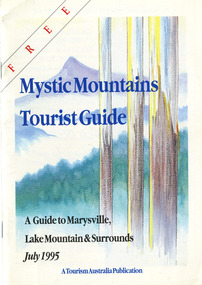
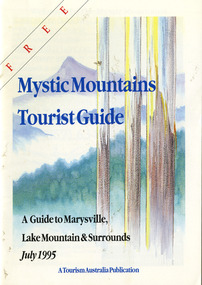
Ephemera (Item) - Tourist Guide, Graeme Haycraft, Mystic Mountains Tourist Guide July 1995, 07-1995
A tourist guide outlining services, accommodation, activities and places of interest to visit in and around Marysville, Lake Mountain and the local district.A tourist guide outlining services, accommodation, activities and places of interest to visit in and around Marysville, Lake Mountain and the local district.Acknowledgements/ Mystic Mountains Tourism Association, Marysville Office of the Dept. of Conser/ vation & Natural Resources, Mrs Elaine Postlethwaite, Ms Sue Henry & every/ advertiser without whose support this Guide would not have been possible.marysville, victoria, australia, tourist guide, mystic mountains, lake mountain, tourism australia, graeme haycraft, magic creek nursery, missing links miniature golf, phelps bakery, blackwood cottages, marysville hotel motel, tower motel, kerami house, marylands guest house, lomatia lodge, willowbank at taggerty, barree mud brick cottages, scenic motel, somerled mountain retreat, dalrymples guest cottages, nanda binya lodge, mathilde's of marysville country guest house, the birches resort, mystic mountains tourist information, marysville caravan park, the cumberland, igloo roadhouse, top shop pancake parlour, the silver birch restaurant, steavenson's restaurant, olde yarra track shoppe, danish coffee gardens, oscars take-away, country touch pottery studio & gallery, cumberland memorial scenic reserve, cathedral range state park, lady talbot forest drive, wishing well, taggerty river picnic area, taggerty river, phantom falls, keppels falls, the beeches walking track, mount sugarloaf, maryton park holiday cottages, snowviews, esa camping & conference centre, wirreanda festival, marysville post shop, hidden talent craft gallery, marysville automotive repairs, geoffrey pope & associates, beauty spot walk, tree fern gully walk, michaeldene track, marysville riding school, gerraty's ski centre, marysville holiday cottages, marysville triangle taxi service, fruit salad farm, lake mountain alpine resort, marysville ski hire, lake mountain ski school, cross country ski hire, lake mountain ski hire, marysville country club -
 Marysville & District Historical Society
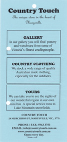
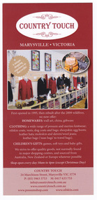
Ephemera (Item) - Advertising brochure, Country Touch, Unknown
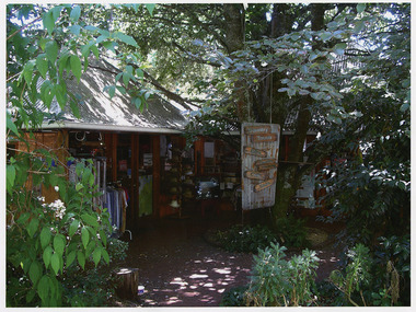
An advertising brochure for Country Touch in Marysville in Victoria.An advertising brochure for Country Touch in Marysville in Victoria. Country Touch was established in 1995 in a mud brick building designed for a pottery studio and gallery on the main street of Marysville in Victoria. By 2003 the pottery kilns were removed and the retail space expanded, however, this was destroyed in the Black Saturday bushfires. In July 2011 the new shop was officially opened and is still trading to this day. marysville, victoria, country touch, 2009 black saturday bushfires -
 Marysville & District Historical Society
Ephemera (Item) - Advertising brochure, Country Touch, Unknown
An advertising brochure for Country Touch in Marysville in Victoria.An advertising brochure for Country Touch in Marysville in Victoria. Country Touch was established in 1995 in a mud brick building designed for a pottery studio and gallery on the main street of Marysville in Victoria. By 2003 the pottery kilns were removed and the retail space expanded, however, this was destroyed in the Black Saturday bushfires. In July 2011 the new shop was officially opened and is still trading to this day. marysville, victoria, country touch, 2009 black saturday bushfires -
 Marysville & District Historical Society
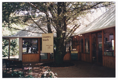
Photograph (Item) - Colour photograph, Unknown
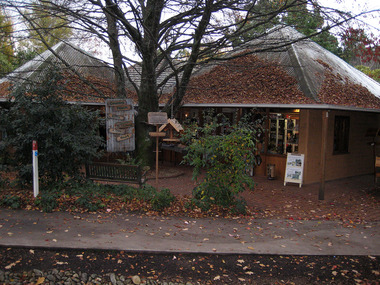
A colour photograph of Country Touch in Marysville in Victoria.A colour photograph of Country Touch in Marysville in Victoria. Country Touch was established in 1995 in a mud brick building designed for a pottery studio and gallery on the main street of Marysville in Victoria. By 2003 the pottery kilns were removed and the retail space expanded, however, this was destroyed in the Black Saturday bushfires. In July 2011 the new shop was officially opened and is still trading to this day. marysville, victoria, country touch, 2009 black saturday bushfires -
 Marysville & District Historical Society
Photograph (Item) - Colour photograph, Unknown
A digital copy of a colour photograph of Country Touch in Marysville in Victoria.A digital copy of a colour photograph of Country Touch in Marysville in Victoria. Country Touch was established in 1995 in a mud brick building designed for a pottery studio and gallery on the main street of Marysville in Victoria. By 2003 the pottery kilns were removed and the retail space expanded, however, this was destroyed in the Black Saturday bushfires. In July 2011 the new shop was officially opened and is still trading to this day. marysville, victoria, country touch, 2009 black saturday bushfires -
 Phillip Island and District Historical Society Inc.
Documents, Shire of Phillip Island et al, 1940's
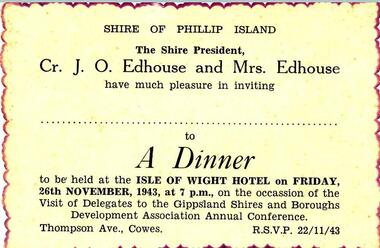
Documents and Photograph donated by the Woodhead family. Dorothy Edhouse was the only child of James & Frances Hill, who were Sylvia Woodhead's grandparents. "James Hill (Jimmy) came to Phillip Island in 1920 and purchased the Hotel, known as Woods Family Hotel. (Later, the Phillip Island Hotel in Walpole Street, now demolished). A milestone occurred whilst in his capable hands, when he installed an electric light plant, (32 volt), the first on the Island. He also made hundreds of cement bricks, when he built his own home. Later he purchased a building in Thompson Avenue, where he established a Billiard Saloon, with a small shop attached. He died in 1937, aged 68. His only child Dorothy Edhouse, is now 95 and has made arrangements to have her ashes added to her fathers' grave." This was added to the photograph of James Hill and Frances Edith Hill - not sure what date it was compiled by Richard Woodhead. Frances died in 1960. The write up was take from "Garden of Memories" by Edith Jeffrey. Four documents/photograph relating to Cr J O Edhouse and his wife Mrs Dorothy Edhouse. Also came with accompanying letter from Sylvia Woodhead. 361-01: An Invitation to a Dinner at the Isle of Wight Hotel - 26/11/1943 - on the occassion of the visit of Delegates to the Gippsland Shires and Boroughs Development Association Annual Conference. 361-03: Identity Card for Dorothy Symes Edhouse. 361-04: Circular from the Liquid Fuel Control Board dated 21st February 1942. 361-05: Photograph of James & Frances Edith Hill. A note saying that James (fondly called Jimmy) came to Phillip Island in 1920 and purchased a hotel - see history below. james & frances edith hill, shire of phillip island dinner invitation, identity card, cr j o edhouse, mrs edhouse, sylvia woodhead, documents -
 Greensborough Historical Society
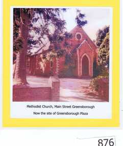
Photograph, Unknown, Methodist Church Main Street Greensborough, 1940c
The Greensborough Methodist Church stood in Main Street Greensborough and was central to the social life of the suburb in the early 20th century. This original site is now part of the Greensborough Plaza shopping complex. The Church moved to the new building in Grimshaw Street circa 1970s. This photograph shows the red brick church, now demolished.Copy of colour photograph of red brick church, mounted on yellow card and laminated.Caption: 'Methodist Church, Main Street Greensborough. Now the site of Greensborough Plaza'methodist church greensborough -
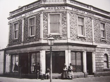 Glenelg Shire Council Cultural Collection
Photograph - Photograph - Compton House, n.d
Displayed at History House.Black and white photograph of Compton House, 3 cornered front, Compton House - T. Hudson - Compton House, written near top of building. Lamp post centre front with two men (one sitting, one leaning) to left, two women (standing) to the right. Stationer Bookseller Shop to one side of Compton House, Brick, timber fence on the other.Front: Compton House, South West Corner, Percy and Henty Streets (typed label). Back: Stamp - State Lib. of S.A. Photographic Section. Reproduction prohibited except withthe permission of the copyright holder. Order No. A/6493 -
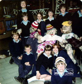 Eltham District Historical Society Inc
Photograph, Primary trip to Greensborough Shopping Centre, Eltham Christian School, August 1982, 1982
Primary trip to Greensborough Shopping Centre, August, 1982 Photos indicate that this may have included an art activity creating puppets with recycled materials. The Stokes family settled in this area of Eltham in the 1940s and were associated with the Eltham Christian Church. In the 1970s this church had met in temporary premises in Eltham. Lots of the original 1920s subdivision remained south of Nyora Road and a number of these lots were utilized for the Eltham Christian School, which was established by the Eltham Christian Church in 1981. The school operated on this site until 2000. The premises were owned by the Nillumbik Community Church who were in operation till November 2010 when the Eltham Baptist Church commenced a lease arrangement until the site was purchased by them in April 2012. The building is constructed of brick and timber with a balcony on two sides that looks over an expanse of grass. Sources: STOKES ORCHARD – AN INCOMPLETE HISTORY February 28, 2015 http://www.elthamhistory.org.au/ Australian Christian Church Histories - Eltham Baptist Church http://www.churchhistories.net.au/church-catalog/eltham-vic-baptist/ From an album featuring a series of photographs (some cropped) from a magnetic photo album relating to the staff, students and activities of the Eltham Christian School which operated as part of the Eltham Christian Church at Nyora Road, Eltham. See also entries for each photograph.three colour photographseltham christian school, nyora road, greensborough shopping centre -
 Eltham District Historical Society Inc
Photograph, Monash Bridge, Arthurs Creek Road, Hurstbridge, Eltham Heritage Tour, 24 May 1992, 24/05/1992
ELTHAM HERITAGE TOUR The Society excursion on 24th May 1992 was arranged by David Bick, leader of the team carrying out the Shire's heritage study. David selected a number of sites or buildings identified in the study, some of them lesser known components of the Shire's heritage. The tour commenced at the Eltham Shire Office at 10.00 am. Travel was by private car and mini-bus with stops at about twelve locations for commentary by David.It included a short walk in Hurstbridge and lunch at Kinglake. Highlights of the tour included: - 10 am Leave from Shire Offices - 3 Important Trees - A Physical Link to Eltham's First Settlers - Toorak Mansion Gates - A Surviving Farm House - An Intact Circa 1900 Main Street - First Settlers - Gold Miners, and Timber-getters - An Early Hotel - A Pioneering Homestead - Changing Eltham Shire - 20th Century - 4 pm Afternoon Tea and Finish Tour Extract from ELTHAM CULTURAL HERITAGE TOUR (Newsletter No. 85, July 1992, by Bettina Woodburn) "On the Arthurs Creek Road is a bridge designed by Monash, which we admired before walking across the little park with a mud-brick and timber shelter, to the Hurst family graveyard. There are two marked graves, one, Henry who was shot by Burke the bushranger and a cairn has a plaque listing others buried here from 1866 onwards. Burke was captured and tied to the wheel of a dray under the eucalypt near the waterhose/standpipe. Close by the kindergarten, at this place are three trees on the National Trust Register, a Canary Island pine, a Canadian cedar and probably a spruce. Radiata pines and a thick bolled peppercorn surround the little cemetery. Continuing along Main Street we notice elm trees planted as a war memorial, then on the left a 1930 timber house, a 1910 store and residence, resplendent with wrought iron trim, a double fronted Hardware Store and cypresses on the back alignment of a new vacant block. On the right side of the street is a less interesting attempt at an 'in character' shop. Further on are more early homes, one tucked away at the rear with two tall palms by the front steps. Another curiosity is a rounded veranda corner and there are more galvanised iron sheds or garages, before a mud-brick Dentist's Surgery. Beyond the round-a-about is St Peters Church, of mud-brick construction shared by Catholic and Anglican parishioners, overlooking the river flood plain. Leaving Hurstbridge on the Kinglake Road, we ate our picnic lunch beside the communication tower and enjoyed views of Melbourne, Yan Yean Reservoir and the distant Dandenongs beyond the spreading suburbs. Next we drove to the North West boundary of the Shire at Masons Falls Road towards Whittlesea. On the way to the North East Boundary we passed St Peters, a yellow wooden Church with a Tudor Archway; built in the early 1920's in the style of the 1860's. From the Healesville-Kinglake road the rolling hills had European aspects, the hedged fields and chestnut trees. Then it was back down the Hurstbridge Road through 'Aussie' bush of towering gums, with bracken and scrubby understorey, the Kinglake National Park, before more open country with deciduous trees planted in line, and a creek lined with willows."Record of the Society's history and activities and highlighting various aspects of the Heritage Study undertaken by David Bick used to create the future heritage overlay for the Shire of Eltham and later Nillumbik Shire.Roll of 35mm colour negative film, 4 stripsKodak Gold 100 5095shire of eltham historical society, activities, heritage tour, hurstbridge, monash bridge, arthurs creek road -
 Eltham District Historical Society Inc
Photograph, Woodburn residence, mudbrick adobe (1949), Eltham Heritage Tour, 24 May 1992, 24/05/1992
ELTHAM HERITAGE TOUR The Society excursion on 24th May 1992 was arranged by David Bick, leader of the team carrying out the Shire's heritage study. David selected a number of sites or buildings identified in the study, some of them lesser known components of the Shire's heritage. The tour commenced at the Eltham Shire Office at 10.00 am. Travel was by private car and mini-bus with stops at about twelve locations for commentary by David.It included a short walk in Hurstbridge and lunch at Kinglake. Highlights of the tour included: - 10 am Leave from Shire Offices - 3 Important Trees - A Physical Link to Eltham's First Settlers - Toorak Mansion Gates - A Surviving Farm House - An Intact Circa 1900 Main Street - First Settlers - Gold Miners, and Timber-getters - An Early Hotel - A Pioneering Homestead - Changing Eltham Shire - 20th Century - 4 pm Afternoon Tea and Finish Tour Extract from ELTHAM CULTURAL HERITAGE TOUR (Newsletter No. 85, July 1992, by Bettina Woodburn) "In some respects Eltham is a 'back-water' and it has its own distinctive flavour. On the outskirts the homes date from the 1960's, 70's and 80s with a sprinkling of 'earth homes', mud-brick or pise, rammed dirt. Crossing Main Road into Beddoe Street and Thompson Crescent a very pleasant drive past pines and old fence lines, front lawns unfenced, the occasional ·old farm building, we eventually looked down on a huge circular roof of a 1992 adobe home. Other distinctive places included the Pauline Toner Butterfly Reserve, Gordon Ford's splendid garden at Fulling in Pitt Street, cypress hedges and old houses in Bridge Street and in every direction Eltham's special feature - a totally treed horizon. We were now in the part of the Shire closest to Melbourne - Montmorency - not on the way to anywhere, with no through road going across it, developed in the 1950's and 1960's with conventional gardens, now converted to native plants. The rail looped between Greensborough and Eltham and a shopping street (Were Street) served the area, growing up the hill from the station. It was a typical outer Melbourne suburb with lawns and roses with patches of originality. The shopping precinct still has 1950 characteristics - walls which sloped back, projecting roofs, the original shop fronts are nearly all tiled below the old windows. There's an air of past times about the School, the Dairy, the Butcher's (now a milk bar) and the Castlemaine stone face of the Commonwealth Bank. The final stop for the tour was at the mud-brick Woodburn residence, adobe of 1949 with additions. After War Service, Bill Woodburn had commenced an Architecture course at Melbourne University and after second year in the Christmas vacation, with his wife, Betti, built the two bedroom house - with amazing saving of costs. In the three and a half months they made over 3000 bricks (external walls 18" x 12" x 4", internal walls 12" x 9" x 4"), sifted top soil for mortar and laid them, on concrete foundations and slab floor, made all the structural window frames, door frames and roof members to carry 'super six' asbestos sheets, laboured for the electrician and plumber, did all the glazing and, still without electricity, moved in in March 1949. Rooms have been added, at first with glass walls, later using concrete blocks, to accommodate three daughters and a son. The house not only grew from the earth, but also with the family."Record of the Society's history and activities and highlighting various aspects of the Heritage Study undertaken by David Bick used to create the future heritage overlay for the Shire of Eltham and later Nillumbik Shire.Roll of 35mm colour negative film, 4 stripsKodak Gold 100 5095shire of eltham historical society, activities, heritage tour, woodburn house -
 Eltham District Historical Society Inc
Photograph, Public toilets, Were Street, Montmorency, c.1990
Photographs of public land in Were Street, Montmorency with public toilets. Before the the erection of the wind mill. Brick paved footpath, angle parking and two public phone boxes.6 colour photographs (2 sets)montmorency, public tiolets, were street, parks, public toilets, shopping centres -
 Eltham District Historical Society Inc
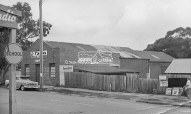
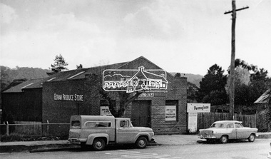
Photograph, Eltham Produce Store, Main Road, c.1960
Operated by John McLean and Son Situated just south from opposite Arthur Street, opposite the Eltham Village Shopping Centre. In 1974 the site was the location of the B.P Garage and opposite was the Woolworths Arcade. The Produce Store sold hay and grain. To the right was Garnet Burges' second hand scrap metal and bottles, then the blacksmith shop, which was later taken over by Garnet with second hand furniture and next door to that was Ray Staff's grocery store. The brick building has signage to promote Tanox Paint and Permoglaze products. This building was demolished by 1963 for the BP Evergreen Service Station. Photo taken at same time as Shire of Eltham Pioneers Photograph Collection No. 785 which is a view from near Arthur Street and Main Road intersection.Colour photograph copy of original photoshops, main road, eltham, eltham produce store, tanox paint, permaglaze, produce station, john mclean and son, garnet burges -
 Victoria Police Museum
Police Stations (Anglesea)
Anglesea is a town on the Great Ocean Road in the Surf Coast Shire local government area. It is 110km from Melbourne. Before 1967 policing in Anglesea was on a seasonal basis with a 'shop front' police station and caravan in the main street. Anglesea Police Station (Barwon District) was opened on 7 February 1967 on the corner of Wray Street and The Great Ocean Road. It was a residential police station, brick veneer with an iron roof with 3 rooms, a bathroom, laundry and a garage. When the station opened it was staffed by one Senior Constable and two First Constables. List of staff from 1967-2002 is available from Victoria Police Museum10 photographs comprising: 8 black and white photos, 2 colour photospolice stations; anglesea police station -
 Eltham District Historical Society Inc
Photograph, Eltham Produce Store, ca 1960
Two vehicles including a Holden FC Special Sedan and ca 1958 Ford 100 truck are parked outside the Eltham Produce Store, Main Road, Eltham near Arthur Street. The brick building has signage to promote Tanox Paint and Permoglaze products. It also sold hay and grain. Operated by John McLean and Son. Situated just south from opposite Arthur Street, opposite the Eltham Village Shopping Centre. To the right was Garnet Burgess' second hand scrap metal and bottles, then the blacksmith shop, which was later taken over by Garnet with second hand furniture and next door to that was Ray Staff's grocery store. The store was demolished by 1963 for the BP Evergreen Service Station. See also: Cross Ref 00161 (print) and 01831-15 (negative duplicate) and SEPP_0785, See 00161, 01831-15, 01895-21This photo forms part of a collection of photographs gathered by the Shire of Eltham for their centenary project book, "Pioneers and Painters: 100 years of the Shire of Eltham" by Alan Marshall (1971). The collection of over 500 images is held in partnership between Eltham District Historical Society and Yarra Plenty Regional Library (Eltham Library) and is now formally known as 'The Shire of Eltham Pioneers Photograph Collection.' It is significant in being the first community sourced collection representing the places and people of the Shire's first one hundred years.Digital image. Copy of original photograph.sepp, shire of eltham pioneers photograph collection, eltham, eltham produce store, main road, tanox paint, permoglaze, holden fc special sedan, ford 100 truck -
 Ringwood and District Historical Society
Letter, Property for sale - Ringwood Shop and Dwelling Estate, Ringwood, Victoria - circa 1925
... consists of Boarding House, (Phone 101) and two shops, mainly brick...) and two shops, mainly brick; 9 inch walls. Will carry another ...ID 5225 note: Further information relating to allotments marked on the hand-drawn plan are included in ID 5224 - Ringwood Station Estate.Typewritten letter from A.V. Greenwood with hand drawn plan of Ringwood Shop and Dwelling Estate, detailed description of property for sale, and top and side elevation views of house. (7 pages)(Transcript of first page - to unknown recipient) Phone 988 Central, 331 Canty Greenwood Pty. Ltd. 5 Flinders Street Melbourne. Dear Sir, 1. Attached please find drawings of my house at Ringwood. 2. It is for sale at £4,865 or to let at £5 per week to an approved tenant. 3. I sold it to Mr. De Garis and vacated it, but it is now back on my hands. 4. I leased another place instead of living in my own. I may be able to cancel same; in the meantime, however, I propose to sell or let my own. The painters are now going through the place; re-varnishing, re-oiling and re-polishing so that in about five days it will look "spick and span". 5. The house was specially built under my own supervision. 6. It is very suitable for a high class Guest House, Doctor's residence, Hospital or Convalescent Home. If you know of anyone whom it might suit, please communicate with them. DESCRIPTION 7. It stands on 305 feet of land facing Greenwood Avenue. It is cement, roughcast and hardwood, well oiled, and is now being redone so that the house is as good as new; red tile roof; verandahs three sides; two sleep-outs; five bedrooms; large dining room; very large music room with nooks, upstairs lounge, study; sewing room; built-in wardrobes and cupboards throughout; handsome kitchen with handsome pantry cupboard with drawers and glass front; one bath room; one shower room; wash house with patent copper and laundry. Every modern convenience, hot water system (through copper pipes with large copper cylinder) electric lights everywhere, outside and in, Yan Yean water laid on everwhere throughout house and gardens. Floors throughout are the very best, close set, stained and polished; dainty lead light windows etc. 8. There is a big garage, with tiled roof and two rooms with all conveniences for a married couple. Property is well drained with a system of its own. The house stands upon the top of a hill close to Railway Station, say 500 feet from the Footbridge. 9. The garden has expansive shrubs; sheds; fernery; tennis court. 10. A handsome piece of furniture goes with the house; a combination pantry and storeroom for groceries, milk, bread etc., consisting of drawers, glass and wire doors, as mentioned above. 11. It is within easy distance of Melbourne as it is only two minutes from Ringwood Station, which is a frequent electric train service bringing it within 39 minutes of the City. It is thought better by some to go further out into the country atmosphere and walk a short distance at the end than to go by train 20 minutes then walk 15 to 20 minutes. 12. The price quoted of £4,865 is made up as follows - 305 feet of land @ £5 ... £1,515 Garage and dwelling ... £300 House hot water system, American cupboard ... £2,600 Water, fencing, sheds & drain ... £250 For the lot ... £4,865 Should you require copies of the enclosed drawings I shall be pleased to supply same. 13. Mr. J.B. McAlpin is the local agent, Phone Ring. 7 (after hours Ring. 44) or you may phone me Central 988. 14. The house is south of the line, facing Greenwood Avenue and immediately at the back of Ringwood House, which is also my property. Yours sincerely, A.V. Greenwood (illegible) ..... (Transcript of second page) RINGWOOD SHOP AND DWELLING ESTATE See these letters on plan attached (H.) Ringwood House and Shops on 100 by 150 feet of land fronting Bedford Road 100 feet @ £10 per foot - £1,000 House and shops - £2,400 ... £3,400 Ringwood House consists of Boarding House, (Phone 101) and two shops, mainly brick; 9 inch walls. Will carry another story. Has music room, dining room, entrance halls, 10 bedrooms, large verandahs, all conveniences, hot and cold water, and stands on what will become a most valuable business corner. (F.)(G.) Mr. Greenwood's house, garage and sheds, stands on 307 feet of land fronting Greenwood Avenue. See detailed description attached ... £4,865 (J.) Cottage on Block 81 in William Street ... £750 (K.) Cottage in Pitt Street ... £650 (Total) £9,665 ..... (Description of third page - Subdivision Plan) Drawn by Edyth Greenwood, phone 988 Central. Subdivision includes Station Street, Pitt Street, Bedford Road, Wantirna Road, James Street, William Street (later Kendall Street), Greenwood Avenue, Ellison Street, and Haig Street. Circles denote blocks for sale. Squares denote house properties for sale. Other features marked include location of businesses along Main Street (Maroondah Highway), cool store, railway station, shop and police station on Bedford Road, church on Station Street, site of schoolmaster's residence and State School, and location of proposed public baths -
 Marysville & District Historical Society
Ephemera (Item) - Tourist Guide, Graeme Haycraft, Mystic Mountains Tourist Guide July 1995, 07-1995
A tourist guide outlining services, accommodation, activities and places of interest to visit in and around Marysville, Lake Mountain and the local district.A tourist guide outlining services, accommodation, activities and places of interest to visit in and around Marysville, Lake Mountain and the local district.Acknowledgements/ Mystic Mountains Tourism Association, Marysville Office of the Dept. of Conser/ vation & Natural Resources, Mrs Elaine Postlethwaite, Ms Sue Henry & every/ advertiser without whose support this Guide would not have been possible.marysville, victoria, australia, tourist guide, mystic mountains, lake mountain, tourism australia, graeme haycraft, magic creek nursery, missing links miniature golf, phelps bakery, blackwood cottages, marysville hotel motel, tower motel, kerami house, marylands guest house, lomatia lodge, willowbank at taggerty, barree mud brick cottages, scenic motel, somerled mountain retreat, dalrymples guest cottages, nanda binya lodge, mathilde's of marysville country guest house, the birches resort, mystic mountains tourist information, marysville caravan park, the cumberland, igloo roadhouse, top shop pancake parlour, the silver birch restaurant, steavenson's restaurant, olde yarra track shoppe, danish coffee gardens, oscars take-away, country touch pottery studio & gallery, cumberland memorial scenic reserve, cathedral range state park, lady talbot forest drive, wishing well, taggerty river picnic area, taggerty river, phantom falls, keppels falls, the beeches walking track, mount sugarloaf, maryton park holiday cottages, snowviews, esa camping & conference centre, wirreanda festival, marysville post shop, hidden talent craft gallery, marysville automotive repairs, geoffrey pope & associates, beauty spot walk, tree fern gully walk, michaeldene track, marysville riding school, gerraty's ski centre, marysville holiday cottages, marysville triangle taxi service, fruit salad farm, lake mountain alpine resort, marysville ski hire, lake mountain ski school, cross country ski hire, lake mountain ski hire, marysville country club -
 Marysville & District Historical Society
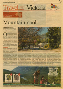
Newspaper (Item) - Newspaper article, The Age, POCKET GUIDE TO MARYSVILLE, 22-11-2008
A newspaper article on Marysville, its local attractions, places to shop and dine, where to stay and ways of traveling to Marysville. This article was published in The Age on Saturday, November 22, 2008.A newspaper article on Marysville, its local attractions, places to shop and dine, where to stay and ways of traveling to Marysville.marysville, victoria, australia, the age, black spur, marysville visitor information centre, steavenson falls, lady talbot drive, taggerty river, keppel falls, phantom falls, beeches rainforest walk, cambarville, yarra ranges national park, the big tree, cumberland walk, lake mountain, steavenson river, acheron river, buxton bait and tackle, marysville trout and salmon ponds, buxton trout and salmon farm, bruno's art and sculpture garden, villa day spa, cathedral view natural therapies, marysville massage, murchison street, village walk, uncle fred & aunty val's old style lolly shop, country touch gallery, manical mechanicals, hidden talent craft gallery, carmyle farm boutique, marysville community market, marysville patisserie, marysville country bakery, fraga's cafe restaurant, terracotta room, marylands country house, the cumberland, mantirri blueberry farm, narbethong, marysville farmers market, the black spur inn, allawah country cottages, barree mud brick cottages -
 Marysville & District Historical Society
Photograph (Item) - Colour photograph, Unknown
A colour photograph of The Log Cabin in Marysville in Victoria.A colour photograph of The Log Cabin in Marysville in Victoria. The Log Cabin was built by Thomas Henry Branchflower who had arrived from England late in 1921. It was built for Gwendoline Pitman after the death of her father Clarence Pitman and the disappearance of her sister Olive in July 1926. Gwendoline operated an artist and souvenir shop in the newly built Log Cabin in partnership with Peter Mackey who was a Melbourne optician and artist.the log cabin, marysville, victoria, thomas henry branchflower, gerald branchflower, mary chain, gwendoline pitman, clarence pitman, kooringa guesthouse, olive pitman, wilbur anderson, peter mackey, photograph -
 Glen Eira Historical Society
Album - Album page, Kambrook Road, Circa 1972
This photograph is part of the Caulfield Historical Album 1972. This album was created in approximately 1972 as part of a project by the Caulfield Historical Society to assist in identifying buildings worthy of preservation. The album is related to a Survey the Caulfield Historical Society developed in collaboration with the National Trust of Australia (Victoria) and Caulfield City Council to identify historic buildings within the City of Caulfield that warranted the protection of a National Trust Classification. Principal photographer thought to be Trevor Hart, member of Caulfield Historical Society. Most photographs were taken between 1966-1972 with a small number of photographs being older and from unknown sources. All photographs are black and white except where stated, with 386 photographs over 198 pages. https://vhd.heritagecouncil.vic.gov.au/places/43737 - re 26 Kambrook Road and 345 Balaclava Road corner building: A prominently situated two-storeyed complex of late Victorian buildings consisting of "Wybar's Buildings" occupying the Balaclava Road/ Kambrook Road corner and the "Caulfield Bakery" facing Kambrook Road, separated by a driveway from a single storeyed shop. The main building has a comer splay and balustraded parapet with curved pediments, the words "Wybar's Buildings 1887" having been obliterated but "Caulfield Bakery 1887" with the characteristic wheatsheaf surviving in raised cement work. The walls are stuccoed and richly ornamented with bracketed cornices and keystones with masks extending to the Bakery. The main building is further distinguished by the Masonic symbol of the mason's dividers in the pediment whilst the upper level of the bakery is in overpainted brickwork. The single storeyed shop incorporates the bracketed cornice and consoles characteristic of the main buildings and is in other respects a utilitarian structure. https://vhd.heritagecouncil.vic.gov.au/places/35413 - re 16 Kambrook Road A small late Victorian Italianate villa distinguished by its parapeted window bays either side of a small verandah with encaustic tiled floor. The parapets are balustraded with console enrichment and glazed tiles, the stuccoed surfaces being unpainted. Ornamentation is in other respects undistinguished. https://www.gleneira.vic.gov.au/services/planning-and-building/heritage/heritage-management-plan - re 9-11 Kambrook Road ... they demonstrate most of the commonly employed aesthetic devices characteristic of the Italianate Style including patterned brickwork, patterned slate roofs, cast iron lace verandahs, ornamental stucco work and ashlar boards...https://vhd.heritagecouncil.vic.gov.au/places/43737 - 345 Balaclava and 26 Kambrook Roads HO91 in City of Glen Eira "Wybar's Buildings" at the corner of Balaclava Road and Kambrook Road are important as a prominent late Victorian commercial development incorporating a variety of activities including a bakery and possibly a coffee palace, the latter understood to be unique within the municipality, but characteristic of the period. It is a rare complex of its type in Caulfield and is important also as evocative evidence of the late Victorian Land Boom and the creation of a small now defunct commercial centre at this location by the George Wybrow. https://vhd.heritagecouncil.vic.gov.au/places/35413 - 16 Kambrook Road HO121 in City of Glen Eira ''Hollywood'' at 16 Kambrook Road is of architectural interest for its pavilions which retain their unpainted parapets and ornamental tiles in the manner of other less imposing examples in the immediate locality possibly linked with the builder George Wybar and his son, who undertook substantial projects nearby. Its association with James Yorston, presumably is Yorston of Dickson and Yorston, important builders and estate developers at Caulfield during the Inter war period is of interest. https://www.gleneira.vic.gov.au/services/planning-and-building/heritage/heritage-management-plan - re 9-11 Kambrook Road HO152 Normanby Road/Kambrook Road, Caulfield North Statement of Significance: The Precinct is historically significant for its capacity to demonstrate standards of design and building construction in this part of the municipality during the late Land Boom years and especially just prior to the bank collapse of 1891. The housing stock is representative of the standards of amenity excepted by the middle classes of Melbourne society at the time, including artists, (horse) trainers, jockeys, managers, travellers, journalists and the like, also having a functional link with the activities of the Caulfield Racecourse which forms an important element in the history of the Municipality. The row of attached pairs at 5-11 Kambrook Road and 53-67 Kambrook Road is especially significant in this respect in that the narrow allotments are indicative of the owner/developer’s determination to maximise profits at the height of the Land Boom in 1891...Page 104 of Photograph Album with four photographs (landscape) of three different properties on Kambrook Road.Handwritten: Kambrook Road [top right] / WYBAR'S BUILDING 1887/ INC CAULFIELD BAKERY / [under top right photo] / 16 KAMBROOK ROAD / 1970 HIRST MRS J.N.[under bottom left photo] / 11-9 KAMBROOK ROAD / 1970 9-BUCKLAND MRS L.A / 11- ATKINS MRS N.E. [under bottom right photo] / 104 [bottom right]trevor hart, kambrook road, victorian, caulfield north, parapets, wybar's buildings 1887, caulfield bakery 1887, architectural features, painted bricks, balaclava road, victorian italianate style, houses, bay windows, verandahs, glazed tiles, shops, george wybar, builders, james yorston, dickson and yorston, j n hirst, l a buckland, n e atkins, patterned slate roofs, patterned bricks, cast iron work, attached houses -
 Glen Eira Historical Society
Album - Album page, Kambrook Road, Circa 1972
This page of photographs is part of the Caulfield Historical Album 1972. This album was created in approximately 1972 as part of a project by the Caulfield Historical Society to assist in identifying buildings worthy of preservation. The album is related to a Survey the Caulfield Historical Society developed in collaboration with the National Trust of Australia (Victoria) and Caulfield City Council to identify historic buildings within the City of Caulfield that warranted the protection of a National Trust Classification. Principal photographer thought to be Trevor Hart, member of Caulfield Historical Society. Most photographs were taken between 1966-1972 with a small number of photographs being older and from unknown sources. All photographs are black and white except where stated, with 386 photographs over 198 pages. First 2 images: milkbar and residence corner Kambrook and Balaclava Roads ie south west corner - building named Airdrie 3rd image: https://vhd.heritagecouncil.vic.gov.au/places/43737 - re 26 Kambrook Road and 345 Balaclava Road corner building ie south east corner: A prominently situated two-storeyed complex of late Victorian buildings consisting of "Wybar's Buildings" occupying the Balaclava Road/ Kambrook Road corner and the "Caulfield Bakery" facing Kambrook Road, separated by a driveway from a single storeyed shop. The main building has a comer splay and balustraded parapet with curved pediments, the words "Wybar's Buildings 1887" having been obliterated but "Caulfield Bakery 1887" with the characteristic wheatsheaf surviving in raised cement work. The walls are stuccoed and richly ornamented with bracketed cornices and keystones with masks extending to the Bakery. The main building is further distinguished by the Masonic symbol of the mason's dividers in the pediment whilst the upper level of the bakery is in overpainted brickwork. The single storeyed shop incorporates the bracketed cornice and consoles characteristic of the main buildings and is in other respects a utilitarian structure. 4th image: https://vhd.heritagecouncil.vic.gov.au/places/42415 (on 24/01/2021) - 196 Kambrook Road An imposing late Victorian poly-chrome brick asymmetrical villa with corner verandah and projecting west facing wing with faceted window bay to the facade. Body bricks are red and relieved by cream and black brick banding and by cream bricks to the bracketed eaves. The fretted barge with king post treatment and timber posted verandah are unique in the Municipality and unusual in the metropolitan area and demonstrate an understated appreciation of the emerging Queen Anne mode.345 Balaclava and 26 Kambrook Roads HO91 - City of Glen Eira https://vhd.heritagecouncil.vic.gov.au/places/43737 (on 24/01/2021) "Wybar's Buildings" at the corner of Balaclava Road and Kambrook Road are important as a prominent late Victorian commercial development incorporating a variety of activities including a bakery and possibly a coffee palace, the latter understood to be unique within the municipality, but characteristic of the period. It is a rare complex of its type in Caulfield and is important also as evocative evidence of the late Victorian Land Boom and the creation of a small now defunct commercial centre at this location by the George Wybrow. 196 Kambrook Road HO122 - City of Glen Eira https://vhd.heritagecouncil.vic.gov.au/places/42415 "Glencoe" is situated at no. 196 Kambrook Road, Caulfield North and was built for the boot manufacturer, Robert Bruce Mair, in 1888. It is of historic and aesthetic significance. It is historically significant (Criterion A) as the home of an inner suburban industrialist, notable a boot manufacturer, demonstrating the attraction of Caulfield as a residential location for the manufacturers of the metropolis during the late Victorian Boom period. It is aesthetically significant (Criterion E) as a very early example of a Queen Anne influenced late Victorian villa, comparing at the State level with ''Woodlands'' (1888), North Essendon, generally acknowledged to be one of Australia's earliest houses to fully exploit this emerging style. The ornamental timberwork is especially expressive of the new architectural fashion and compares with the house at 33 Clarence Street, Elsternwick (1888-89).Page 105 of Photograph Album with two photographs of a milk bar and attached residence, one older photograph of Wybar's Building and another photograph of a house on Kambrook Road (all are landscape).Handwritten: 196 KAMBROOK ROAD / 1970 - GAFFNEY MRS S.M. [under bottom right photo] / 100 [bottom left]trevor hart, kambrook road, victorian style, caulfield north, parapets, wybar's buildings 1887, caulfield bakery 1887, architectural features, painted bricks, balaclava road, george wybrow, shops, milk bars, airdrie, polychrome bricks, verandahs, queen anne architectural style, houses, glencoe, robert mair -
 Glen Eira Historical Society
Album - Album page, Glenmoore, St George's Road, Circa 1972
This photograph is part of the Caulfield Historical Album 1972. This album was created in approximately 1972 as part of a project by the Caulfield Historical Society to assist in identifying buildings worthy of preservation. The album is related to a Survey the Caulfield Historical Society developed in collaboration with the National Trust of Australia (Victoria) and Caulfield City Council to identify historic buildings within the City of Caulfield that warranted the protection of a National Trust Classification. Principal photographer thought to be Trevor Hart, member of Caulfield Historical Society. Most photographs were taken between 1966-1972 with a small number of photographs being older and from unknown sources. All photographs are black and white except where stated, with 386 photographs over 198 pages. From Victorian Heritage Database citation for HO59 Glenmoore, 1 St Georges Road Elsternwick https://vhd.heritagecouncil.vic.gov.au/places/35202 as at 30/10/2020 "Glenmoore" is locally significant as a surviving mid nineteenth century villa residence in the then fashionable bi-chromatic brick form. It is also important as the home of Hugh Moore who built several shops in nearby Glen Huntly Road and which remain as important contributors to the architectural character of the Elsternwick Shopping Centre.Victorian Heritage Database citation HO59 Glenmoore, 1 St Georges Road Elsternwick https://vhd.heritagecouncil.vic.gov.au/places/35202 An imposing two storeyed villa in bichrome brick with two storeyed timber posted verandah, coupled with cast iron lace frieze, spandrels and central tympanum enrichment. The hipped roof is in slate and has a prominent crean1 brick chimney stack forming part of the facade. Openings are flat arched although the entrance is round arched with a fan light. The south elevation has bayed windows. Two storeyed hip roofed additions are sympathetic and attached on the north side and at the rear. Inside, the staircase and stained glasswork with initials "HM" and family coat of arms are important surviving elements. INTEGRITY: Good, timber outbuildings of an early date, mature and spacious front garden includes early palm trees. Alterations include reconstruction of facade verandah including tiled pavement and front door on east side. Interior has a high level of integrity. Original grounds included adjoining "Carramar".Page 178 of Photograph Album with three photographs of Glenmoore, St Georges Road. Handwritten: "Glenmoore" 1 St George's Road [top right] / 178 [bottom right]trevor hart, chimneys, porch, mansion, slate roof, return verandah, stained glass, cast iron frieze, glenmoore, 1860's, hugh moore, glenmoore estate, double storey, elsternwick shops, st george's road, thomas watts, elsternwick, victorian style, protruding bay windows, cast iron work, bi-chromatic bricks, gardens, balconies, moore's buildings, glen huntly road, stairs, house names -
 Glen Eira Historical Society
Album - Album page, Old Fire Station, 4 Selwyn Street, Circa 1972
This album was created in approximately 1972 as part of a project by the Caulfield Historical Society to assist in identifying buildings worthy of preservation. The album is related to a Survey the Caulfield Historical Society developed in collaboration with the National Trust of Australia (Victoria) and Caulfield City Council to identify historic buildings within the City of Caulfield that warranted the protection of a National Trust Classification. Principal photographer thought to be Trevor Hart, member of Caulfield Historical Society. Most photographs were taken between 1966-1972 with a small number of photographs being older and from unknown sources. All photographs are black and white except where stated, with 386 photographs over 198 pages. From Victorian Heritage Database citation for H2376 Former Elsternwick Fire Station, 2-4 Selwyn Street Elsternwick - Victorian Heritage Register https://vhd.heritagecouncil.vic.gov.au/places/2645 (as at 21/11/2021) The Former Elsternwick Fire Station was built and commenced operation in 1896. It was one of 32 new fire stations built between 1892 and 1896 by the newly formed Melbourne Metropolitan Fire Brigade ('MFB') to form a comprehensive fire-fighting network across Melbourne. The MFB was established in 1891 as Victoria's government-run fire-fighting service in Melbourne and its growing suburbs. By 1918 motorised fire engine appliances had replaced horse-drawn fire vehicles across the metropolitan area, and the consequently larger areas that fire stations could protect meant the 1896 Elsternwick Fire Station was one of many which was becoming obsolete. The MFB continued to use the Elsternwick Fire Station up until the Station's closure in 1926. From 1927 the former Fire Station was leased by neighbouring timber merchants JJ Webster Pty Ltd who subsequently purchased the property from the MFB in 1934. From 1954 the 'Esquire Motors' car repair business traded at the site, and changes to the former Fire Station building including the complete enclosure of its yard by corrugated steel walls and roofing appear to have been completed in the mid-1950s. In 1990 the Australian Broadcasting Corporation ('ABC') purchased the former Fire Station together with five other adjoining land parcels in Selwyn Street. From that time until 2017 the former Elsternwick Fire Station has been used by the ABC as office and storage space in its Selwyn Street television studio complex.From Victorian Heritage Database citation for H2376 Former Elsternwick Fire Station, 2-4 Selwyn Street Elsternwick - Victorian Heritage Register https://vhd.heritagecouncil.vic.gov.au/places/2645 (as at 21/11/2021) The Former Elsternwick Fire Station is historically significant as one of the 10 remaining fire stations of the original 32 built for the newly established Melbourne Metropolitan Fire Brigade ('MFB') during the four-year period 1892 to 1896. These fire stations were constructed following the establishment in 1891 of the MFB, Victoria's government-run fire-fighting service for metropolitan Melbourne and its growing suburban population. These new stations formed a crucial part of the MFB's fire-fighting network across Melbourne. The Former Elsternwick Fire Station clearly demonstrates the historical development of fire-fighting services in Melbourne, especially the expansion of the newly-formed MFB throughout Melbourne's suburbs during the 1890s. [Criterion A] The Former Elsternwick Fire Station is architecturally significant as a fine example of a late nineteenth century fire station. Constructed shortly after the establishment of the MFB, it displays characteristics of its class of place that remain mostly unchanged from the former Station's historically important period of development and use. A particularly strong element of the Former Elsternwick Fire Station is the large and strikingly-detailed stone horseshoe arch, designed for horse-drawn fire-fighting vehicles, at the street entrance to its fire-engine room. [Criterion D]Page 188 of Photograph Album with two photographs of the old Elsternwick Fire Station.Handwritten: old fire station 4 Selwyn Street [top right] / 188 [bottom right]trevor hart, rendered, 1890's, melbourne metropolitan fire brigade, mfb, fire-fighting, jj webster, timber merchants, esquire motors, car repair, australian broadcasting corporation, abc, selwyn street, brick and stone, asymmetrical facade, anglo-dutch gable, rusticated and smooth-faced limestone, elsternwick fire station, elsternwick, fire station, jj webster pty ltd, motor vehicle repair shops, stone horseshoe arch entrance -
 Glen Eira Historical Society
Photograph, Beauville Avenue, 17, Murrumbeena, 2001
Originally labelled "Beauville Estate, Established 1936, Still Thriving 65 years on, 10th March 2001", the Beauville Estate Album contains colour photographs of houses in the Estate. They were taken around the time of the Beauville Estate’s 65th Heritage Celebration held on 10/03/2001 and donated to the Caulfield Historical Society shortly afterwards. Photographer unknown.City of Glen Eira’s Heritage Management Plan Vol 2 p79 (this is p84 of the pdf version) – HO12 Beauville Estate and environs, Murrumbeena: The Beauville Historic Area is important at the State level as the first large housing estate undertaken by the AV Jennings Construction Co, later Jennings Group Limited, Victoria’s largest home builder. It is important also as a very early estate development incorporating a range of features other than houses and including made roads, shops and recreation facilities. In this respect it was the forerunner of the comprehensively planned housing estate of the post war era. The estate is distinguished by its aesthetic values, as is the earlier and comparable Hillcrest Estate, which are formed by a combination of restrained diversity in house styles, with the exception of no. 30 in the emerging International style, and by a landscaped garden environment. Colour photograph of the porch of an unpainted variegated brown brick house. The porch features decorative brickwork with arched entrances, lantern light and cast iron gates. murrumbeena, houses, beauville avenue, architectural styles, 1930's, inter war style, a.v. jennings, av jennings, jennings, brick houses, beauville estate, porches, arches, sir albert victor jennings, a v jennings construction co, beauville estate heritage area, glen eira city council, architectural features, jennings group limited, land subdivision, gardens, beauville historic area, brick features, cast iron gates, cast iron lights