Showing 93 items
matching building supplies
-
 Eltham District Historical Society Inc
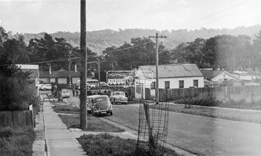
Photograph, Looking down Pryor Street to Main Road, Eltham, c.1960
Eltham Plumbing Supplies (Lennie Whiteway Plumbing) located on the right side of the street. It later became the Eltham Bookshop and sold cane ware as well. On the corner with Main Road is the local branch of the State Bank of Victoria. The building still stands and is the present day Westpac bank branch. The Railway Station Master's house on opposite side was later demolished to make way for a carpark. 27 Aug 1963: Pettion for Bankruptcy re Jeanette Patricia Whiteway of 88 Napoleon Street, Eltham, house duties, and lately carrying on a business at Pryor Street, Eltham in partnership with another as a plumber under the names Eltham Plumbing Supplies and L. & J.P. Whiteway 1963 'SEQUESTRATION ORDERS AND FIRST MEETINGS', Commonwealth of Australia Gazette (National : 1901 - 1973), 12 September, p. 3259. , viewed 10 Jul 2018, http://nla.gov.au/nla.news-article241015035 Orders for discharge of bankruptcy suspended till 23 March 1967 for Leonard Whiteway and Jeanette Patricia Whiteway of 5 John Street, Eltham 1967 'NOTICE OF ORDERS OF DISCHARGE', Commonwealth of Australia Gazette (National : 1901 - 1973), 11 May, p. 2427. , viewed 10 Jul 2018, http://nla.gov.au/nla.news-article241040009Black and white photograph prints (x3) Negative (copy) 4x5 large format Black and White (x2)Shire of Elthampryor street, eltham plumbing supplies, main road, eltham, eltham bookshop, jeanette patricia whiteway, lennie whiteway plumbing, leonard whiteway, state bank of victoria, station masters house, westpac bank -
 4th/19th Prince of Wales's Light Horse Regiment Unit History Room
Booklet, Specification for Supplies. The "SX" Series. Expense Supplies, Fuel/Light and Forage 1965, 1965
A hard covered, loose leaf book setting out the conditions of quality control for expense supplies, fuel/light and forage itemsDSN 7610-66-010-1935supplies, expense -
 Kiewa Valley Historical Society
Book - Reference S.E.C. History x4, Brown Power A Jubilee History of the State Electricity Commission of Victoria, first published 1969
Although this book revolves around the supply of power(Electricity) from brown coal it does cover the period 1937 onwards when the Kiewa Hydro Electricity Scheme was first mooted. This area was believed to be far away from aerial bombardment should the coastal power stations be attacked by air in World War II(1939 -1945). After the war, post 1945, the demand for a continual power supply, not affected by seasonal coastal flooding was together with a lower cost of hydro electricity power the major incentive for the Victoria Government of the day to proceed (in the 1940s) with The Kiewa Hydro Electricity Scheme. In 1946 Victorian government sought greater independence from the New South Wales black coal supplies.The significance of this book to the Kiewa Valley and its outlying regions is that it details why the development of an Alpine region was and now still is pocketed with a European flavour both in buildings and in town vegetation(trees and flowers). European (post World War II refugees) where attracted to these alpine areas not only for hard labouring positions but also for their technical skills and some street names offer a distinct European lineage rather than convict or of earlier English settler. The construction phase accommodation continued after completion of the Kiewa Hydro Electricity Scheme to become popular venues for an increasing winter tourism industry. This book has a brown hard cover encapsulated by a cream sleeve with brown and black print. On the front of the sleeve is an embossed circular motif with centre piece S.E.C. emblem and around this the words "50 YEARS OF SERVICE" and below this" STATE ELECTRICITY COMMISSION OF VICTORIA". The book contains 313 double sided pages of black print and black and white photographs.On front of paper sleeve "Brown Power A Jubilee History of the State Electricity Commission of Victoria Cecil Edwards". On the second page, below the Title "Brown Power" there is a pasted, printed presentation certificate, with the S.E.C. emblem and these printed words " Presented by the Chairman and Commissioners to A.G. MILLIST, ESQ. in recognition of long and valued service with the Commission"electricity, victorian power supplies, hydro electricity, brown coal, cecil edwards -
 Eltham District Historical Society Inc
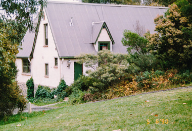
Photograph, Victorian Artists Supplies, 715 Main Road, Eltham, 5 June 1990
Victorian Artists Supplies was established in 1987 in this beautiful mud brick building.Colour photographmain road, victorian artists supplies, mud-brick -
 Flagstaff Hill Maritime Museum and Village
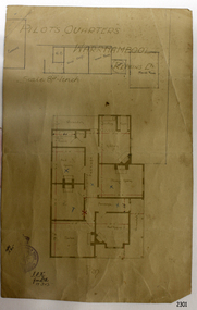
Document - Plan, Pilots Quarters Warrnambool
Warrnambool was officially made a Port of Entry in 1855 and by the 1870s had became the dominant port in the Western District. Sadly, due to an increasing problem with silting in the harbour, by the 1890s only small vessels could navigate the harbour. Men with the position of Pilot and Harbourmaster in Warrnambool were employed by the government to enforce government regulations and to help guide vessels safely into the port of Lady Bay, which was difficult to navigate. Some of the Pilots and Harbour Masters of Warrnambool were – - Captain Christopher Gwatkin, the first Harbourmaster for Warrnambool (1857 - his death in 1859). - Captain Helpman was Warrnambool’s second Harbourmaster 1859-1869 - James Nicol was Harbourmaster in Warrnambool for a time, including 1906 (b. 1840 – d. 1926) - Thomas Smith Drewett (1853 - 15-3-1905) past Captain of the Helen Nicoll, Pilot and Harbourmaster of Warrnambool. Warrnambool’s Tourist Guide of 1888 advises that “At the Port of Warrnambool there are two Leading Lighthouses. A licensed sea pilot, Captain Drewett, is stationed at the Port.” In 1915 plans for the Pilot’s Quarters were drawn up for the Department of Public Work. It was at that time, when personnel was short due to the First World War, that apparently the Pilot and Harbourmaster was also responsible for maintaining the light (lighthouse). The new Pilot and Harbourmaster’s house would be built on the site at 88 Merri Street, overlooking Lady Bay and right beside the Flagstaff and the Lady Bay Upper Lighthouse. Other Pilot and Harbourmasters were - - James Menzies was the Pilot and Harbourmaster at Warrnambool in 1929 . In 1932, he was appointed to the position of Acting Secretary to the Warrnambool Harbour Board. A hundred or so years later Flagstaff Hill Maritime Village has fully renovated the former Harbourmaster’s quarters, changed the name to Lighthouse Lodge, and is now allowing guests to stay in the home, which is still neighbour to the operational Lady Bay Lighthouses, now over 150 years old. The association of the old Pilot and Harbourmaster’s Quarters (currently renamed as Lighthouse Lodge) with the Port of Warrnambool, and its maritime activities, is historically significant. The Pilot’s quarters are connected to a time when access to Warrnambool’s Port was important to the colonial settlers for income and supplies. Plan of Pilots Quarters, Warrnambool. Printed and handwritten plan shows house, garage, out buildings and maid's room. The plan's lower left corner has an official stamp and text beside the stamp. Department of Public Works, Melbourne, Victoria, March 11th, 1915. "PILOTS QUARTERS WARRNAMBOOL" "Department of Public works, Melbourne, Victoria I.P.K. , 11.3.15"flagstaff hill, warrnambool, shipwrecked-coast, flagstaff-hill, flagstaff-hill-maritime-museum, maritime-museum, shipwreck-coast, flagstaff-hill-maritime-village, plan, pilot's quarters warrnambool, pilot and harbourmaster's quarters warrnambool, pilot and harbour master's quarters warrnambool, port of warrnambool, department of public works victoria, lady bay lighthouses, warrnambool ports and harbours -
 Flagstaff Hill Maritime Museum and Village
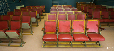
Furniture - Theatre Chairs, 1930's
These theatre chairs had been used in the Mozart Hall in Warrnambool for many years but are now no longer required. They were about to be offered for anyone to take but just by chance Flagstaff Hill’s Manager heard about them from a friend in Melbourne. Our Manager thought it important to keep the chairs in Warrnambool as they were significant to our local history and could be incorporated in our Museum. He made arrangements to collect and install them in Flagstaff Hill’s Theatrette. Originally these theatre chairs belonged to Warrnambool Town Hall. When The Warrnambool Baths (or Swimming Pool) in Gillies Street closed, due to the Health Act of 1958, the changing rooms were taken over by the Mozart Group. The building was modified and set up for musical concerts with the name Mozart Hall. The seats were re-covered by Miss Eva Gaspar, Director of the Warrnambool Music Society, with assistance from group members. The material was order by W.C. James (Treasurer) in 1964, at a cost of 26 pound and 10 shillings (£26-10), and supplied by Jacka-Wortley Fabrics Pty Ltd, Upholstery and Furnishing Supplies, 157-163 Pelham Street, Carlton, Melbourne, Victoria. The supplier’s telephone was “JACKAFAB” (5222 2322). The fabric was delivered to J. Hulin of 116 Belmore Rd, Warrnambool. The manufacturer of the chairs, Riddell & Preece Pty Ltd of Melbourne, also supplied theatre chairs for other public buildings including (1) the Ozone Theatre in Enfield, South Australia, in 1929, (2) the Gallery of the Horsham Town Hall in Victoria (at 26/6 each, that is 26 shillings and sixpence, approximate conversion in 2014 to $100.00au), (3) in 1927 in the Gallery of the Kyenton Mechanics’ Institute (4) in 1926, Horsham Theatre. (In May 2018 a transfer of three banks of chairs was made from Flagstaff Hill to the Australian Centre for the Moving Image in Melbourne.) The chairs are of local historical and social significance. Theatre chairs. The sixteen sets (groups or banks) of complete chairs, four seats per chair, give a total of 64 seats. Each chair has timber framed seats, with arm rests, upholstered in red vinyl. The seats are set into decorative gilt iron frames which incorporate five legs, all set into two timber floor rails. The seats are hinged to fold upwards and rest against the backrests. On ironwork "PTY. LTD"flagstaff hill, warrnambool, shipwrecked coast, flagstaff hill maritime museum, maritime museum, shipwreck coast, flagstaff hill maritime village, great ocean road, theatre chairs, theatre seats 1939, warrnambool town hall seats, mozart hall warrnambool, theatre furniture, mechanics’ institute chairs, j hulin warrnambool, mozart hall choral group, eva gaspar, warrnambool music society, w.c. james, jacka-wortley fabrics pty ltd -
 Bendigo Historical Society Inc.
Administrative record - Provisions Register 1897 - 1908
The Benevolent Asylum was established to provide both indoor and outdoor charitable relief for the destitute and aged. Initially it was in a slab and weatherboard building before getting it's permanent home in 1860. (Now Ann Caudle Centre). From 1868 - 1885 an industrial school for children was included. In 1884 a Lying in Hospital was included and this closed in 1920.Bendigo Benevolent Asylum Provisions Register 1897 - 1905. Green coloured marbled pattern cover with red and white tape on the spine with lined ledger pages. The ledger includes the provisions acquired and dispersed each day. All entries handwritten in ink. Standard supplies included with space to add special items.bendigo benevolent asylum, provisions register -
The Ed Muirhead Physics Museum
Photograph, Cyclotron accelerator
Builit in 1950s and used till the mid 1970s within the Physics Department used in Melbourne. John Rouse and David Caro was involved in the construction.Black and white photo of cyclotron (nuclear physics accelerator): H.V. Power supplies & acceessories. Sticky typed labels on back from top and left to right: “4KV DRIVER POWER SUPPLY, 14KV RECTIFIER SET, 14KV CHOKE, OIL PUMP & HEAT EXCHANGER” Handwritten in pencil on top left hand corner: “6” -
Bendigo Historical Society Inc.
Document - BENDIGO OPERATIC SOCIETY COLLECTION: ANNIE GET YOUR GUN 1989, June 15, 16, 17, 22, 23
A program for the 1989 play Annie Get Your Gun, now playing for the second time in Bendigo since 1971. Playing at the J. B. Osbourne Theatre in Kangaroo Flat and featuring Carol McKenzie- Grose as the director and the actors Sheryn Long and Craig Thomas as the main roles, Annie Oakley and Frank Butler. Also featuring the actors Wayne McCashen as Charlie Davenport, Glad Weatheritt as Dolly Tate, Glenn Grose as Tommy Wheeler, Heather Jelbart as Winnie Tate, Andrew Jenkin as Buffalo Bill, Kenn Dunn as Sittig Bull, John Adams as Pawnee Bill, Travor Bailey as Foster Wilson. Starring as the Indians are Grant Thomas, Hilary Bottcher, Deryck Jenkin, Clare O'Sullivan, Kerryn Miller, Kate O'Sullivan, Dan Clancy, Paul Veitch, Rob Jealous, Ross Jones, Starring as the children of the story are Darrah Hanley, Kirsty Wilson, Melinda Coughlin, Linda Robertson, Dougal McArthur, Shae McCashen, Rochelle Rowe, Amy McArthur. Starring as the Chorus of the show are Danielle Rowe, Colleen Heenan-Warnecke, Melinda Rowe, Sue Stanyer, Juliette Frietschi, Angela Rashleigh, June Long, Kathy Howard, Marion Malpass, Grace Cox, Kate Adams, Christine Howard, Renee Wilson, Melinda Saunders, Margaret Maher, Alistair Rowe, Jack Paynting, Jim Dunn, Mathew Frank. Featuring the following as Dancers, Fiona Coyle, Terri Watson, Toni Brandie, Christine Fitzgerald. And for the people behind the play itself, Rosemary Overton as the Musical Director, Alex Campbell as the Pianist, Geoff Hamblin as the Stage Manager, Mary Ferguson as the Wardrobe and Viktoria lee as the Choreographer Also featuring advertisements from local Bendigo businesses such as Roy Leache Music Centre in Allans Walk, Pall Mall, Ron Poyser Holden in High St, Ideal Greenhouse in Huntly Bendigo Mail Centre, John J. Kennedy Accounting at Pall Mall, Barton Buckle Casting Co, Horseworld in 122 Mollison Street, Brooks Catering, Phil Beer & Fletchers Photographics at 100 Mitchell St, The Green Carnation in 101 Queen Street, Karl's Koffee Haus in 95-97 View Street, Ganet's Art Supplies in Allans Walk, Bendigo Building Society in Bull St.bendigo, entertainment, capital theatre, bendigo theatre co, inc. bendigo operatic society. roy leache music centre in allans walk, pall mall, ron poyser holden in high st, ideal greenhouse in huntly bendigo mail centre, john j. kennedy accounting at pall mall, barton buckle casting co, horseworld in 122 mollison street, brooks catering, phil beer & fletchers photographics at 100 mitchell st, the green counation in 101 queen street, karl's koffee haus in 95-97 view street, ganet's art supplies roy leache music centre in allans walk, pall mall, ron poyser holden in high st, ideal greenhouse in huntly bendigo mail centre, john j. kennedy accounting at pall mall, barton buckle casting co, horseworld in 122 mollison street, brooks catering, phil beer & fletchers photographics at 100 mitchell st, the green counation in 101 queen street, karl's koffee haus in 95-97 view street, ganet's art supplies in allans walk, bendigo building society in bull st. -
Tatura Irrigation & Wartime Camps Museum
Photograph, Minor Outlet from Waranga Basin, 1957
Taken by photographer for State Rivers and Water Supply Commission.Large, black and white photograph. Large square concrete building set in stone wall, water right foreground, stones left foreground, two men on top of wall left of building, windmill just visible above roof of buildingbelow photo: "Minor outlet from Waranga Basin / Supplies water to parts of West Rodney and Tongala Districts."victoria state rivers and water supply commission, waranga basin, irrigation -
 The Royal Children's Hospital Archives
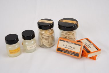
Functional object, Vaseline x 2, Finger Cots x 2 Jars, Litmus Paper x 3
Jars and boxes of medical supplies"Finger cots" "Vaseline" "Six red litmus test books, Johnsons of Hendon LTD" -
 Whitehorse Historical Society Inc.
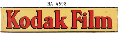
Functional object - Kodak Sign, 1925
Installed on building at 528 Whitehorse Road, Mitcham between 1938 and 1944. Building was a Newsagency and Post Office.Patrick and Bertha Markham operated the newsagency and post office on this site from 1925 to 1944. In the late 30s a range of photographic and developing services and supplies were added to the business. The sign was installed under the veranda on the Whitehorse Road frontage to advertise Kodak services. Also, their daughter Mary was a keen photographer and started a business as a child photographer. In 1944, both her parents died and Mary inherited the premises and continued the Kodak agency as part of her business. Mary and her husband, Harold, sold the former Mitcham post office to the PMG in mid 1957 and removed the Kodak sign as they departed.Metal sign L 1220cm x H 295cm . Yellow background with red lettering 'Kodak Film'. Sign has black edging. Sign is identical both sides.Kodak Filmcommerce, signs -
Southern Sherbrooke Historical Society Inc.
Information folder - Belgrave Heights Convention Ground
Information folder containing items pertaining to the history of the Belgrave Heights Convention Grounds. Contents: -map, "Belgrave District Road Map" showing locations in Belgrave Heights & South -map "Belgrave Heights Road Map" showing Convention Grounds, buildings and other local sites -Various items photocopied on single sheet, inc. token for Gospel Supplies, Belgrave Heights; item re. Rudi Atwood, minister; list of hymns; photo of Main St, Belgrave. -
 Kew Historical Society Inc
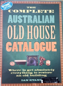
Book, Flannel Flower Press, The Complete Australian Old House Catalogue, 2000
"If you own an old house, The Compete Australian Old House Catalogue will save you time, money and effort. Thanks to this book, finding the products, materials, skills and services needed to care for and restore your old house - from the front fence to the chimney pots - is now a simple matter. Ian Evans has collected the names of companies and people who can help you return your house to its original appearance and condition. Some 750 entries list the names of suppliers throughout Australia who specialise in every aspect of building restoration. For the first time, entries include e-mail and website addresses where these are available. Each chapter opens with introductory text which provides concise background information on the subject, drawn from Ian Evans's research into old Australian houses. Practical advice on many aspects of building conservation is combined with authoritative historical information, creating a unique and fascinating blend. The illustrations consist of a selection from old and new building catalogues, together with a wealth of archival and modern photographs. This is a book which belongs in every old house throughout the length and breadth of Australia." - back cover.96 p. : ill. ; 29 cm.non-fiction"If you own an old house, The Compete Australian Old House Catalogue will save you time, money and effort. Thanks to this book, finding the products, materials, skills and services needed to care for and restore your old house - from the front fence to the chimney pots - is now a simple matter. Ian Evans has collected the names of companies and people who can help you return your house to its original appearance and condition. Some 750 entries list the names of suppliers throughout Australia who specialise in every aspect of building restoration. For the first time, entries include e-mail and website addresses where these are available. Each chapter opens with introductory text which provides concise background information on the subject, drawn from Ian Evans's research into old Australian houses. Practical advice on many aspects of building conservation is combined with authoritative historical information, creating a unique and fascinating blend. The illustrations consist of a selection from old and new building catalogues, together with a wealth of archival and modern photographs. This is a book which belongs in every old house throughout the length and breadth of Australia." - back cover.interior decoration -- australia -- equipment and supplies -- directories., houses and domestic architecture. -
 Kew Historical Society Inc
Photograph - Former Kew Police Station : Parking lot, 1996
A civic campaign for new public offices developed in Kew in the 1880s. After much deliberation, the location chosen was the junction of Bulleen and Cotham Roads. The buildings were designed by George Watson and John Henry Harvey, architects within the Department of Public Works (Victoria). Building was commenced in 1887, and after one year, the buildings were opened. The Post Office was transferred to the new Commonwealth Government in 1901. The Police Station and Court House, sold by the Victorian Government to the City of Boroondara in 2007, are now a community cultural centre and performing arts venue.The buildings were listed on the Victorian Heritage Register Register (HO885) in 1991. They are historically and architecturally significant to the State of Victoria because Watson and Harvey's designs exhibit diversity in integrating civil offices, they accommodate the apex of road junctions, and they demonstrate a departure from the contemporaneously favoured High Victorian Classical to the Queen Anne style in the design of civic buildings.View through the old wire gates into the parking lot behind the former Kew Police Station and Court House. This was the entrance from Cotham Road with which supplies, prisoners, and police cars would enter.kew court house, public offices -- kew (vic), kew police station -
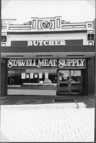 Stawell Historical Society Inc
Photograph, Stawell Meat Supplies Butchers shop in Main Street Stawell built in 1876 1991
Stawell Meat Supplies Butchers shop in 1991 located in Main street in building built 1876 stawell business -
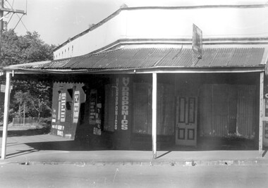 Surrey Hills Historical Society Collection
Photograph, 109 Union Road, Surrey Hills after fire damage
This building was damaged by fire and was subsequently demolished before June 1983. From 1901-1917 it was the site of the Surrey Hills Post Office. In later years the part of the building with frontage to Windsor Crescent was used as the dental surgery of Dr David Ellis; the Union Road part of the building was occupied by a barber and tobacconist for many years. At the time of the fire the building was used by a business supplying hydroponics requirements. This moved to (?) 119 Highbury Road, Burwood.The image is significant because it documents a building which was an important community facility which no longer exists.Black and white photo of a single-storey corner building with a corrugated iron roofed veranda and a single, 4-panel timber door. There is a sign with '109' mounted on the veranda of the building. There are multiple advertising signs on the walls of the building. Two of the windows are boarded up with corrugated iron sheets.shops, barber shops, tobacconists, surrey hills post office, dentists, union road, windsor crescent, hydroponics supplies, businesses, union road shops, dr david ellis -
 Surrey Hills Historical Society Collection
Photograph, Union Road, Surrey Hills in 1982 (3), 1982
Taken in January 1982; very similar to SHP0628 & SHP0635. Surrey Family Hotel (McNeill's Family Hotel) was built in 1888 by Alexander McNeill. It closed as a hotel after the Local Option vote in 1920. The Surrey Squash Courts were built in what had been the Surrey Theatre. The facade of the ANZ Bank building documents the past history of the building having earlier been the ES&A Bank. Black and white photo of Union Road at the intersection of Canterbury Road. On the right the edge of Dartnell's Pharmacy building on the SE corner can be seen and McNeill's Family Hotel building (pre-renovation) on the NE corner. Distinguishable advertising signs include the ANZ Bank and Dalkeith Office Supplies on the west side of Union Road beyond the intersection; also the Surrey Squash Courts.businesses, shops, union road shops, dartnell's pharmacy, mcneill's family hotel, surrey family hotel, anz bank, surrey gardens, dalkieth office supplies, surrey squash courts -
 Surrey Hills Historical Society Collection
Photograph, Stand-pipe at the corner of Warrigal and Riversdale Roads, Surrey Hills, c1916, c1916
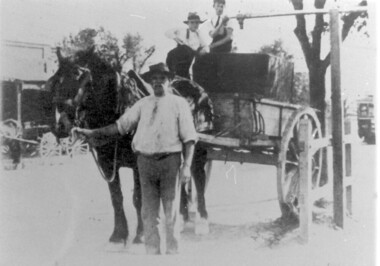
This was part of an exhibition mounted by the Surrey Hills State Savings Bank in 1976. The original print had a text which was included in our copy print as follows: "EVEN IN 1916, WATER SUPPLIES FOR MANY SURREY HILLS FARMERS AND MARKET GARDENS STILL / CAME FROM THE STAND-PIPE AT THE WARRIGAL ROAD TRAM TERMINUS. PREVIOUSLY WATER WAS / PURCHASED FROM THE VILLAGE TANK AT THE CORNER OF WINDSOR CRESCENT AND UNION ROAD. / THE PRICE WAS 1/- FOR 400 GALLONS."Black and white photo of a horse and water cart in position at the stand-pipe. A man holds the horse's reins and 2 young boys are perched on the cart. In the background is a building that may be a shop with wagons outside and further down the road is a tram.horse-drawn vehicles, water supply, warrigal road, riversdale road, transport, surrey hills, standpipe -
 Falls Creek Historical Society
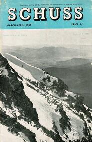
Journal - Schuss Vol. 19. No. 2 March - April 1953
Schuss was advertised as Victoria’s Official Ski Journal It was issued monthly from 1935 to 1961 except during the war when summer issues covered two months. This continued after the war, but it averaged 10 issues annually over its 25 year life. Schuss was published by the Ski Club of Victoria which had a membership of 38 Ski Clubs and demanded to be recognised as the prime authority on skiing in the state. The other 30 ski clubs with 85% of the members disagreed and the politics of skiing became heated. These clubs formed the Federation of Victorian Ski Clubs with their own journal, Ski Horizon. With the establishment of the Victorian Ski Association, Ski-Horizon published its last issue in Nov - Dec. 1955 and the role of the official journal was fully taken over by “Schuss”. This item is significant because it contains stories, images and information documenting the development of the ski industry in Victoria.The journal features stories and events chronicling developments in Victoria and internationally. Items related to the Falls Creek Area in this issue include:- Cover - Features a photo by H.Gibbs titled "Western Cliffs of Mt. Bogong" Page 65 - BOB HYMANS reported news of Falls Creek. At his own Ski School, notable improvements to accommodation have been made and additions to the building itself, which will make it very much more comfortable and serviceable to visitors. Water supply and heating are amongst the items in hand. Bob has acquired a Land Rover which will be a power of assistance to him in maintaining fresh supplies and in servicing his project generally. Kiewa Valley Ski Club members are making splendid progress with the erection of their Lodge. This is the latest building addition in that area and raises the number of clubs resident there to nine. Nissen Ski Tow members intend to operate their tow on the upper slopes of Falls Creek every day during the coming season that conditions permit. They are to be warmly commended on their enterprise. Page 65 - Advertisement for Bob Hymans' Ski School and Lodgeschuss journal, bob hymans, kiewa valley ski club, nissen tow -
 Melton City Libraries
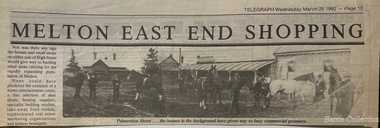
Newspaper, Melton East end shopping, 1992
TOM COLLINS–from the reel to reel tape recording at Melton 1969 In the years between 1890 and to about 1913 Melton was a quiet little hamlet alongside the Toolern Creek, once called the Pennyroyal Creek, 24 miles from Melbourne on the Ballarat Road. There was a fair amount of woodland left around it, mostly grey and yellow box with sheoak, and golden wattle, which in spring time made a rather attractive setting. Most of the premises were in the main or High Street, with its line of elm and pepper trees on each side. Unitt, McKenzie and Henry streets each contained only a few dwellings. Hotels were four in number, Minns’s, Mrs Hay licencee, now Mac’s, Golden Fleece – Sheblers. The Royal or Ryan’s as it was then called, later Graham had the licence, and the Raglan - Kilpatricks had the licence and afterwards Tom Manning. This was situated about where Mr K. Young had his residence. There was a store attached to the hotel until about 1900. Both the Royal and the Raglan were delicensed, later on the Royal being converted to a green grocery and a boarding house, the Raglan was demolished. The Royal green grocery and boarding house was kept by E Carew and after he retired, E Radford. The Post and Telegraph Office was on the opposite side of the street to the Raglan Hotel about two doors west of the Shire Hall and was kept by Mrs Ferris and Lady Farmer until her retirement, when it was carried on by Miss Lottie Ross. A store was attached to the Post Office and was sometimes used as a store and at one time housed the National Bank. There were two full time banks at Melton, the other being the Commercial which built premises about 1904 and on the corner of High and Smith Streets, which it still occupies. Mr G Egan was the manager of the Commercial and Mr Stradling and later Mr Lee of the National. However as business was not thought good enough they reverted to a part time branch operated from Bacchus Marsh. Grocer shops were Chalmers, with a news agency and drapery now Arnolds, Jongebloeds had the bakery. Mr Fox also a produce merchant, was where Melton Real Estate is now, it was later occupied by Buchanans, Atleys, and Mrs Ross. Not long after the War Mrs Ross built the Post Office, since demolished where Miss Lottie Ross was the Post Mistress and later built the store which she conducted. It was later turned into a factory and in now the barbers shop. McNichols was just west of the Minns Hotel. He travelled as far a Ballan weekly, buying calves and dairy produce for sale in Melbourne. Afterwards he sold the business and bought Minns Hotel and changing the name to Macs. Blacksmiths were three in number. Blackwoods – later James Byrnes next door to Jongebloeds. Alex Cameron who learnt his trade with Blackwoods had his shop about the rear of where Ken Youngs Garage is now he later moved to the north west corner of High and Alexander Street. He was also the Registrar of Birth and Deaths and Electoral Registrar. After his retirement he was weighbridge keeper at Melton South. Two of his sons were engaged in the carpentry trade, but both died at an early age. Whittingtons shop was a few doors east of the Mechanics Hall and it was later occupied by Gordon Macdonald who did business there until about eight years ago. The butchers of the period were George Graham, that is where Mandy Lees hairdressing establishment is now. Euan MacDonald had premises later occupied by Whittingtons blacksmith shop. Later shifting next door. He left here about 1901, he slaughtererd animals at a slaughter house right where Chas Jones now resides, it had previously been a slaughter house and butcher shop of that site. George Spring also operated as a butcher for two or three years about the 1900 or so. Ted Simpsons shop was where John Kontek now has his Estate Agency, he used it as an branch shop from Bacchus Marsh bringing meat from there by a two horse lorry. Jimmy Butler the manager was well known and loved, his son was later a steeplechase jockey. The Court House and Police Station would be built sometime before 1900. The Constables at the time were McGuire, later Wade, Riely and McKenzie after that Robert Wilson and Seinfort were here, they were a bit later on. The Mechanics Hall was first opened by Ryan of the Royal Hotel who sold it to the Hall Committee. It was on Unitt Street and it was moved by McLellans the house shifters from Unitt Street to its present site. Bluestone premises formerly occupied by the bootmaker Carew, were later demolished and replaced by the brick frontage to the Hall. Keith Orensini [?] the local bricklayer built brick portion to the Hall. In the cottage adjoining the Hall a Frenchman named Baudin, had a boot repairing business.This cottage was the later residence of J Hill, a local carpenter and builder from whom I learnt my trade. Granny Watts was the well known local nurse and operated the Mid-Wifery Hospital in Yuille Street on the Sherwin Street corner. Mrs Nissen was on the opposite side of Yuille Street a short distance nearer the township. She conducted the laundry. Carew had a greengrocers shop next door to the Post Office in the High Street for some time before transferring to the Royal Hotel site. He also bought [?] calves for killing. W Cecil was a tank maker and also had a produce round, he lived on Pyke and Sherwin Street. Later Gus Shebler, builder and carpenter engaged in tank making being well known for good workmanship. Shebler was very energetic in forming the Gun Club which met for a good number of years where the golf course now has its headquarters. Of the four churches only three are in use, Christ Church, Scots and St Dominics. The Methodist closed down but later transferred to Melton South. Monthly stock sales were held at the yards in Unitt Street at Minns Hotel by McPhail Auctioneers, later held by McCarthur and McLeod. After the Council built the pound and sale yards they transferred sales to these premises, but lack of patronage caused them to be abandoned. A familiar sight in the district was blind Bob Nixon, who lived in a tumbled down cottage in Centenary Road near W Coburns, being led by his dog down the road to Melton, that is Palmerston street, to the Post Office, butcher and baker for his supplies and then back home. He was able to do his own cooking and other chores. Sundays he would come down Raleighs Road to the back of the church and tie his dog to a tree. Someone, mostly one of the boys would guide him into the church and out again after the service, when the dog would lead him home again. State School 430, a two roomed bluestone building it was the only school in the district, none at Melton South. The nearest would be Rockbank and Toolern Vale. Scholars had a fair distance to walk in most cases. The teachers were Mr T Lang Headmaster. I put a query here, Miss Winters, I’m not certain of the name, Mrs Skinner and Miss Silke as Assistant Teachers. Miss Augusta Cecil and Miss Maud Lang were Junior teachers. One boy who attended the school about the turn of the century was Hector Fraser who resided with his parents in Keilor Road, where Jim Gillespie now lives. He was an excellent gun shot and at the age of about 17 years his father took him to France or Monaco where he won the Gran Prix for pigeon shooting and became the champion boy shot of the world. However he died there from pneumonia. He shot under the name of “Parvo”. The Melbourne Hunt Club used to meet in Keilor Road north side just east of the Toolern Creek on what was originally Pykes Run. This was also the place where the races were held and the Sports Meetings. Dave Murphy, employed at Clarke’s Rockbank Station usually provided the fox which he liberated for the Club. Greyhound coursing was usually held on Moylans property Mt Kororoit, or Mt Misery as it was known then. Later it was held at Melton Park, Mr Matt Carberry was the judge and Percy Cook the slipper. Early in the 1900’s the Recreation Park was created and the Caledonian and the ANA sports meetings were held there, they were annual events. L Paterson from Melton South was a successful competitor in all the cycling events as a young man. He later in life became the Deputy Chief Officer of the Metropolitan Fire Brigade. The present Chief Officer of the Fire Brigade is John Paterson, nephew of his, and spent his early life in Exford where his father was manager of the Exford Estate. Notes Tom Collins was born c 1895. He lived on the south side of the Ballarat Road near the intersection of Keilor Road.Historical image of Palmerston Street in Meltonlocal architecture, landscapes of significance -
 Linton and District Historical Society Inc
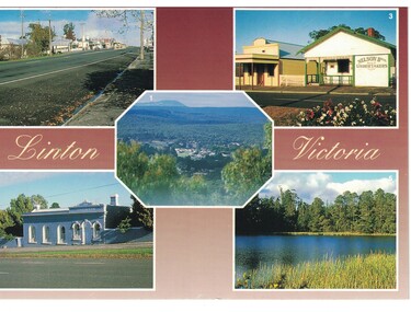
Postcard, Albury Souvenir Supplies, Linton, Victoria
Postcard with five colour images of places and buildings in Linton, Victoria. The images are of Linton from Flagstaff Lookout, Sussex Street, Linton, Free Library, Traquair House and the Reservoir at Linton.flagstaff lookout, sussex street linton, traquair house, linton reservoir -
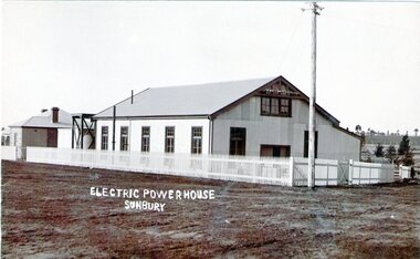 Sunbury Family History and Heritage Society Inc.
Photograph, Sunbury Powerhouse, c21st June 1910
The powerhouse in Sunbury began generating electricity for the town in 1908 after the Shire of Bulla saw the benefits of the town having electricity. It functioned until 1924 until the State Electricity Commission took over the project. The post card was written on 21 June 1910 and sent to a Miss Hillary who was living in Benalla. It was from her cousin Mr. Gregor who was a Sunbury resident. From the date on the card, the photograph must have been taken shortly after the powerhouse began operating. An engineer's cottage was built at the rear of the main building and it is still standing on its original site in Jackson Street,The establishment of an electricity supply for the town of Sunbury by the Shire of Bulla in the early decades of the twentieth century was a very advanced decision and brought lots of benefits to the town.A non-digital sepia photograph in post card format of the former Electric Powerhouse at Sunbury with a short message and address written on the back of the photograph To H.Hillary at Benalla from M.J.Gregor in Sunbury ELECTRIC POWERHOUSE/SUNBURY.electricity supplies., gregor, a., sunbury powerhouse -
 Falls Creek Historical Society
Photograph - Axtrack oversnow vehicle Falls Creek Hotel
This vehicle, an Axtrack is located outside the Falls Creek Museum. It was built by Axel Andre who worked in Falls Creek as a mechanic for several years in the early 1970s. Axel was an engineer by trade. He built this small twin track vehicle for Ivan Spargo at the Falls Creek Hotel and then progressed to building bigger and better models. This included one for Ziggy Doer at Koki and Neville Mashford at Snowland purchased two of them. Some of these machines were also exported to America. Axel Andre later established a company Axtrack Engineering in Melbourne. There are still three of these Axtrack vehicles on the hill at Falls Creek in 2024. The vehicles were used for commercial purposes such as transporting supplies and staff around the mountain. The Spargo family from the Falls Creek Hotel used this vehicle for oversnow transport and it advertised Harvey Wallbanger Happy Hour. Ivan and Joy Spargo relocated from Melbourne to Falls Creek in 1965. They purchased a piece of leasehold land and built Spargo Lodge. This was a dorm style chalet built to accommodate large groups and families. Their son Rob Spargo met his future wife Blanche in 1967 when she was on holiday in Falls Creek. They married and purchased the site where the Falls Creek Hotel is today. The steep gradient of the site was a challenge to build on but was the best location available in the village. In 1970 Rob’s sister Leonie and her husband Glenn joined the business, and they started operating the hotel in 1972. The family played a critical role in the growth of the Falls Creek community and were involved in the foundation of Falls Creek Primary School and Falls Creek Search & Rescue. Rob was also involved in the start-up of Ski Victoria and has served as a member of the Chamber and Resort Management Board. Rob’s eldest daughter Lisa competed with the Australian Ski Team from 1985 to 1989 and has worked as a ski instructor in Australia, Austria & Colorado. In 2010 Lisa and her husband Damien Allport joined the family business and her parents retired to Tawonga South in 2014. Their children are now the fourth generation of the Spargo family living at Falls Creek enjoying the alpine lifestyle and providing outstanding hospitality. The 40 year tradition of the Harvey Wallbanger Happy Hour held on Tuesdays and Thursdays continues at Falls Creek Hotel in 2024.This item is significant because it depicts an important form of transport at Falls Creek, VictoriaA coloured photo of a black Axtrack oversnow vehicle decorated with red and yellow advertising.FALLS CREEK HOTEL APRES ENTERTAINMENT HARVEY HOUR TUES & THURS 3.30 PM LIVE ENTERTAINMENTaxtrack, oversnow vehicles, falls creek transport, spargo lodge, falls creek hotel -
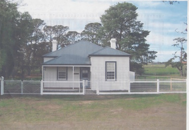 Sunbury Family History and Heritage Society Inc.
Photograph, Former Engineer's Cottage
The building was the residence of the engineer who was responsible of managing the early electric supply that was installed in Sunbury in 1909. The town's power supply put an end to gas lighting that had been used and homes had the benefit of having electricity connected to their homes. In 1926 the State Electricity Commission took over supplying electrical power to Sunbury. The cottage is now a private home and the power house building has been demolished. he complex occupied land on the corner of Jackson and Shields Street.At the time the electric supply was installed in Sunbury in 1909, few small country towns had electric power connected.A non-digital scanned coloured photograph with a narrow white border of a small double fronted wooden cottage with a corrugated iron roof with trees growing behind the building.electricity, engineer's corrage, jackson street, shields street, power supplies -
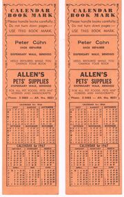 Bendigo Historical Society Inc.
Domestic Object - BENDIGO MUNICIPAL LIBRARY CALENDAR BOOK MARK, 1967
The Bendigo Municipal Library opened May 3rd 1950 in the Shamrock Hotel Buildings.Bendigo Municipal Library Calendar Book Mark: 2 x orange card with black print inside a scroll border is * Calendar Book Mark from Bendigo Municipal free Library. Hours of opening. Advertising as follows: Chemist Jack L. Lyons. Marie Salon Ladies hairdresser. Flowers by Lorraine. Reliant Watch Repair Service C.R. Harris. On the back again within the scroll border is * Calendar Book mark. Please handle books carefully. Do not turn down pages - Use This Book Mark. * Peter Cohn Shoe Repairer. Allen's Pets' Supplies.* Under the advertising is the Calendar for 1966/1967. Box 625Brochure Publishing Co.bendigo, council, libruary, bendigo library -
 Melbourne Tram Museum
Document, Melbourne & Metropolitan Tramways Board (MMTB), "Preston Workshops", Nov. 1926
Set of two typed reports detailing Preston Workshops. .1 - Report - marked draft, dated 24/11/1926 - 4 foolscap pages with marks, corrections, changes outlining the need for a workshop, refers to the Malvern depot, acquisition of the land, design, capacity, description of the various shops. Gives a description of the operation, construction of trams in the future, notes the cable repair shops at Nicholson St, cranes, employee numbers, costs, paint and body shop. Notes the mess room and that an ambulance room will be provided. .2 - Report - 3 quarto pages - undated - but based on the first sentence, c1929 - titled "Tramway Workshops Preston". Gives a description of the workshops, the main groupings, building sizes, cranes, floors, building and maintenance capacities, tracks, admin block, employment, sub-station and power supplies.In top right hand corner of each sheet of .1 "Reference RS 49/1" stamp and handwritten.trams, tramways, preston workshops, malvern depot, nicholson st, workshops, workplace conditions -
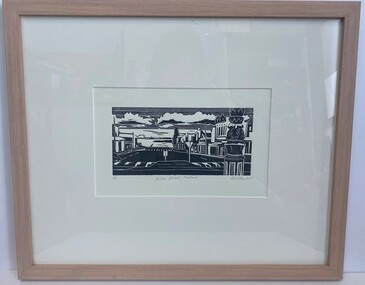 Glenelg Shire Council Cultural Collection
Artwork, other - Linocut, Bob Stone, Julia Street, 2007
Artwork features streets from Portland Victoria.Black and white linocut print. Image based on Julia Street Portland Victoria showing the Street and buildings looking toward the ocean. Foreground right an up close replicate of the sign pole of the middle of the roundabout between Percy and Julia Street, raised road crossings, road signs, Norfolk Island tree, ocean is visable with various Port structures. Sky is lined with clouds shaded black underneath.Along the bottom of the print written in grey lead 4/5 Julia Street, Portland Bob Stone 2007portand, julia street portland, linocut -
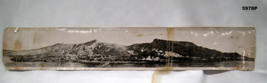 Bendigo Military Museum
Photograph - PHOTOGRAPH, GALLIPOLI, cWW1
Original owner - Stephen John PARISH Regiment number/ Unit 703, Enlisted 19-08-14 F.COY 8th Battalion Became an officer 2nd Lieutenant in 1st Machine Gun Battalion RTA 17-03-1919 See also Cat No. 5979.6.Original photograph - black and white on photographic paper. Scene depicts landing boats, beach scene, an encampment with tents and small buildings with background of ridges. Handwritten greeting and information on back of photograph. Panorama photograph.Handwritten in faded black ink - back of photograph "Clevedon/ 3/7/18/ Just a picture of Gallipoli/ if you show it to any of/ the boys that have been/ there they will explain it/ better than I can by writing/ best love/ Ste ? xx" Handwritten in mainly uppercase letters, blue ink. Left to Right - " MOST OF OUR/ SUPPLIES WERE/ LANDED HERE" " THE LAST OF/ THE AIF LEFT/ HERE 29-12-1915" " 1ST AIF DIVISION/ LANDID (sic) HERE/ 25-4-1915" " THIS PERE WAS/ RECKED (sic) SEVERAL/ TIMES BY STORMS" " 1ST AIF/ HOSPITAL TENTS " TURKS BEACHIE (sic) / FIRED SCHRAPNIL/ ALONG BEACH/ FROM HEARE (sic)" " 4th INF BGDE/ Faught (sic) have/ on 9-5-1915" . "photographs, ww1, gallipoli, s. j. parish, 8th battalion -
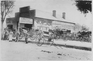 Bacchus Marsh & District Historical Society
Photograph, H.Moffatt Coachbuilder General Blacksmith Main Street Bacchus Marsh
H. Moffatt, blacksmith, opened new brick premises in 1899 on the site of a similar building burnt down the previous year. He continued to operate as a coachbuilder and blacksmith on this site until 1927 when he retired. Since then, the premises have been used for coffin making, a hardware store, furniture store, bathroom supplies among other things. It is now operating as Lola's Restaurant.Black and white photographic print. Dating from the early 1900s, this photograph is of a substantial brick building opened in 1899 by Mr H. Moffatt at 110 Main Street on the site of a similar building which burnt down in 1898. A sign at the front reads: H.MOFFATT COACHBUILDER GENERAL BLACKSMITH. A number of horse-drawn carriages, two and four-wheeled, stand on the footpath, roadway and on the vacant block next door. The road appears to be unmade and is separated from the elevated footpath by barge boards. Advertising signs line the side wall of the building. Four men stand on the road, three wearing the leather apron worn by blacksmiths, one wearing a long white apron as was often worn by shop assistants. Horse droppings, a common sight in those days, can be seen on the roadway. shops bacchus marsh vic., main street bacchus marsh vic., h. moffatt, coachbuilders, general blacksmiths