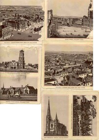
Showing 471 items
matching central and east
-
 Kew Historical Society Inc
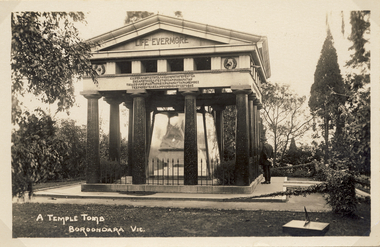
Postcard, A Temple Tomb Boroondara Vic, 1914-1920
A temple tomb in the form of a Greek temple with a triangular pediment. Dark pillars on a flat, paved base support the plinth of the memorial. The memorial is situated on lawn, surrounded by trees and shrubs. Between the pillars, a glass enclosure can be clearly seen. The enclosure was removed at a later date. Harold Desbrowe-Annear designed the Springthorpe Memorial, while Bertram Mackennal sculpted the statuary on the sarcophagus. William Guilfoyle is belived to have advised on the design of the garden.Photographic postcard of the east facing side of the Springthorpe Memorial in the Boroondara General (Kew) Cemetery. The photograph of the tomb record the original glass case surrounding the central group of statuary as well as a man at right contemplating the tomb. An interesting feature is the vine in the foreground covering the chain. There is also a small sundial at lower right.springthope memorial, boroondara (kew) general cemetery - victoria - australia, funerary monuments, postcards -- cemeteries -
 Bendigo Historical Society Inc.
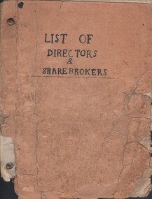
Document - MCCOLL, RANKIN AND STANISTREET COLLECTION: LIST OF DIRECTORS AND SHAREHOLDERS, 1950/61
Documents: paper bag contains - well-worn booklet 21x16cm 'List of Directors & sharebrokers' for goldmines, meeting times, reports to press, company report recipients for Monument Hill Consolidated, Central Nell Gwynne, East Clarence, New Don, South Nell Gwynne, Deborah Gold Mine, South Deborah, North Virginia, Central Deborah, North Deborah Mining, Nell Gwynne Reef, Central Napoleon, New Monument, North Hustlers, Napoleon Reef, Deborah Extended, Deborah United, South Wattle Gully Company, Red, White & Blue Extended, Golden Carshalton, poor condition, also several company change of address notices.MCCOLL RANKIN AND STANSISTREETorganization, business, gold mining - legal, mccoll rankin and stansistreet -
 Ringwood and District Historical Society
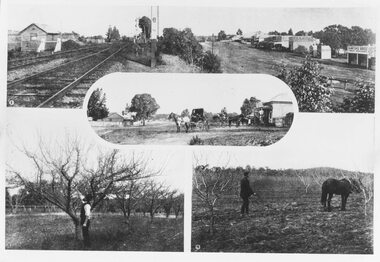
Photograph, Photos from a Weekly Times newspaper article featuring images of early Ringwood and East Ringwood circa 1910 (6 photos), Circa 1910
Shops, houses and hotel(s) were originally regarded as being in central Ringwood and later as Ringwood East after the commercial and residential developments gradually centered further west around the Railway Station precinct after train services commencedFive photographs; Ringwood Railway Crossing; Ringwood Shopping Strip; Pruning Demonstration; Shops, houses and hotel(s) in Mount Dandenong Road; Ploughing.Written on backing sheet, "Photos from Weekly Times. Check with H.A." -
 Kew Historical Society Inc
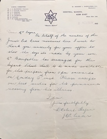
Document, Letter, to Mrs Rogers / from Junior Red Cross, 1939, 1939
This work forms part of the collection assembled by the historian Dorothy Rogers, that was donated to the Kew Historical Society by her son John Rogers in 2015. The manuscripts, photographs, maps, and documents were sourced by her from both family and local collections or produced as references for her print publications. Many were directly used by Rogers in writing ‘Lovely Old Homes of Kew’ (1961) and 'A History of Kew' (1973), or the numerous articles on local history that she produced for suburban newspapers. Most of the photographs in the collection include detailed annotations in her hand. The Rogers Collection provides a comprehensive insight into the working habits of a historian in the 1960s and 1970s. Together it forms the largest privately-donated collection within the archives of the Kew Historical Society.Letter to Dorothy Rogers from the Junior Red Cross. Letter to Mrs Rogers written in 1939 by Robert Hogan on behalf of the Junior Red Cross movement thanking her for the loan of toys made by her son and wishing him a permanent recovery from his illness. The letter is on Central School Kew East letterhead.junior red cross, central school kew east, dorothy rogers -
 Southern Sherbrooke Historical Society Inc.
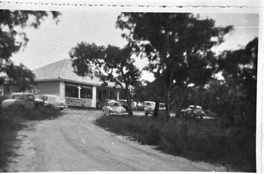
Photograph - Narre Warren East shop
Black and White Photograph of the Narre Warren East shop, possibly taken 1953-1956, featuring a building at the top of a driveway. About seven cars are parked out the front of the building. The shop has a high-pitched roof, a central door, and large windows or a verandah. Under the left windows is an advertisement for Swallows ice cream. There are trees surrounding the shop. This was the first and only store in Narre Warren East. It is now a house on Wellington Road. The home and store was built by Bert Dorning, and the Dornings opened and ran the store. -
 Lara RSL Sub Branch
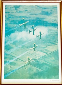
Photograph, RAAF Roulettes Aerobatics Team
The Roulettes are the Royal Australian Air Force's formation aerobatic display team. They provide about 150 flying displays a year, in Australia and in friendly countries around the Southeast Asian region. The Roulettes form part of the RAAF Central Flying School at RAAF Base East Sale, Victoria.In 1970, the Roulettes were formed to celebrate the RAAF's 50th anniversary to be held throughout the year of 1971. The Roulettes first air show was at Point Cook in Dec 1970Rectangular shaped glass covered picture frame with photo of the Roulettes flying in formation.RAAF 'Roulettes' aerobatic team Photographer: Cpl John McKeonraaf, roulettes, aerobatic flying team, lara r.s.l. -
 Bendigo Historical Society Inc.
Document - CENTRAL NELL GWYNNE - NOTES ON CENTRAL NELL GWYNNE
Handwritten notes and carbon copy on the Central Nell Gwynne Mine. Notes mention the depth of shaft, locality, gold yield and dividends. Also mentioned is the area selected by the Bendigo and District Tourist Association as a mining tourist and historical centre.Also mentioned is the Hercules no 1, Pearl East, Hercules New Chum and the Carlisle.Also in the notes are alterations for a proposed booklet. It mentions Collman & Tacchi, Great Extended Hustlers, Lazarus, Barnet Lazarus, United Devonshire, West United Devonshire, Confidence Extended, Johnson's No 2, New Argus, South New Moon, Lansell's Comet and the Central Red, White and Blue.document, gold, central nell gwynne, central nell gwynne, notes on central nell gwynne, bendigo and district tourist association, jack barker, hercules no 1, pearl east, hercules new chum, carlisle, collman & tacchi, great extended hustlers, lazarus, barnet lazarus, united devonshire, west united devonshire, confidence extended, johnson's no 2, new argus, south new moon, lansell's comet, central red, white and blue, baling of water -
 Eltham District Historical Society Inc
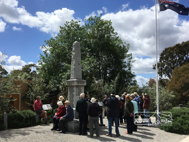
Photograph, Peter Pidgeon, Eltham War Memorial, 903-907 Main Road, Eltham, 4 November 2017, 4 Nov 2017
Eltham District Historical Society heritage walk to follow the boundaries of the original Shillinglaw Farm in central Eltham, held Saturday, 4th November, 2017. The Shillinglaw Farm comprised Lot 90 of Holloway’s 1851 Little Eltham subdivision. It was originally 30 acres in area and situated east of the Diamond Creek and north of Henry Street.Born digital imageeltham war memorial, obelisk, war memorial buidings, war memorial hall -
 Eltham District Historical Society Inc
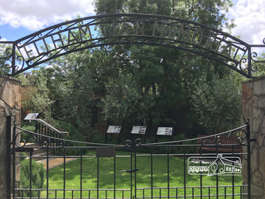
Photograph, Peter Pidgeon, Eltham War Memorial, 903-907 Main Road, Eltham, 4 November 2017, 4 Nov 2017
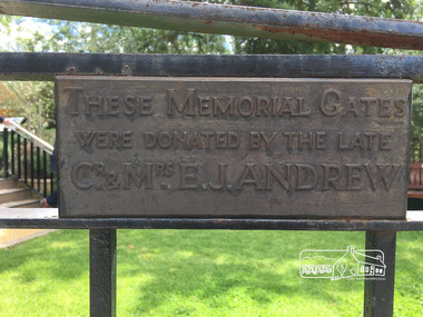
Eltham District Historical Society heritage walk to follow the boundaries of the original Shillinglaw Farm in central Eltham, held Saturday, 4th November, 2017. The Shillinglaw Farm comprised Lot 90 of Holloway’s 1851 Little Eltham subdivision. It was originally 30 acres in area and situated east of the Diamond Creek and north of Henry Street.Born digital imagecr. e.j. andrew, eltham war memorial, ernie andrew, war memorial buidings, war memorial garden, war memorial gates -
 Eltham District Historical Society Inc
Photograph, Peter Pidgeon, Eltham War Memorial, 903-907 Main Road, Eltham, 4 November 2017, 4 Nov 2017
Eltham District Historical Society heritage walk to follow the boundaries of the original Shillinglaw Farm in central Eltham, held Saturday, 4th November, 2017. The Shillinglaw Farm comprised Lot 90 of Holloway’s 1851 Little Eltham subdivision. It was originally 30 acres in area and situated east of the Diamond Creek and north of Henry Street.Born digital imagecr. e.j. andrew, eltham war memorial, ernie andrew, war memorial buidings, war memorial garden, war memorial gates -
 Kew Historical Society Inc
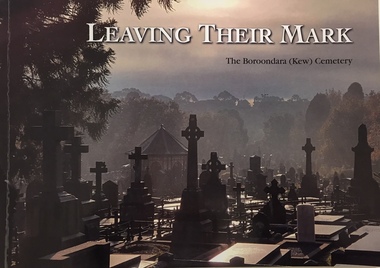
Book, Friends of Boroondara (Kew) Cemetery, Leaving their mark : a tribute to some of those who are memorialised in the Boroondara (Kew) Cemetery, est 1958, 2020
xii, 108 pages : illustrations, portraits ; 21 x 30 cmnon-fictionburials -- boroondara general cemetery, funerary monuments -- kew (vic), cemeteries -- victoria -- kew -- history, kew (vic.) -- biography -
 Ringwood and District Historical Society
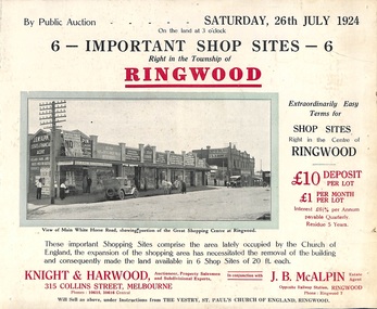
Flyer, Shop Sites Sale By Public Auction, Ringwood, Victoria - 1924
Folded double-sided brochure advertising six Ringwood shop sites for sale by Public Auction at 3pm, Saturday, July, 1924, with town photographs, location map, and summary of local features and services. Includes newspaper extract from the Real Estate and Property section from "Evening Sun", 6th June, 1924.Locality plan highlights shop sites for auction east of Pratt Street along Whitehorse Road. (Agents) Knight & Harwood, 315 Collins Street, Melbourne, Phones 10615, 10616 Central, in conjunction with J.B. McAlpin, Estate Agent, Opposite Railway Station, Ringwood, Phone Ringwood 7. -
 Ballarat Tramway Museum
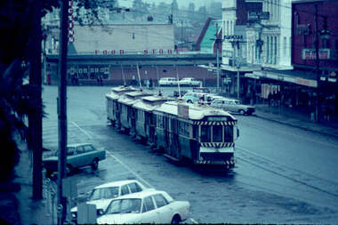
Slide - 35mm slide/s, Noel Simons, Aug. 1971
Plain white cardboard transparency slide of Ballarat No. bogie tram (No. 34) and three single truckers in the City Loop on a wet Ballarat day. Taken from central median strip, looking south east. Has Dickins Food store and shops along the south side of Sturt St. near Grenville St. in the background, including Thomas Jewellers and the Jack Gaffin? Union Hotel"City Loop" and "Aug 1971" in blue ink.tramways, trams, city loop, sturt st, tram 34 -
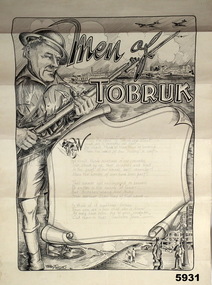 Bendigo Military Museum
Souvenir - SKETCH, MEN of TOBRUK, C.1941
"Terry Toone" is actually Frederick John Toone NX55874 J Section Workshops, 9th Div Supply Column. Enlisted 2.7.1940 age 36 years 6 months, appointed L/Cpl 12.8.1940, embark for the Middle East 27.8.1940, serves in Seige of Tobruk, he spends time in Hospital, embarks for Australia 2.4.1942 and is discharged Medically unfit on 29.9.1942. Item in the collection re Ron Bollard VX14150, refer Cat No 5919P for his service details.Sketch on card, B & W drawing of a soldier on left, heading is "Men of Tobruk" followed by a central scroll with a poem hand written in pencil, behind main cartoon shows a town "Tobruk" with aeroplanes, at bottom shows a town with civilians. On rear in black pen are details re copyright and who item returned to, either direct to him (T Toone) or his wife in East St Kilda Melbourne.On front at bottom in pencil, "Terry Toone Tobruk 15.9.41", On rear signed in black pen, "F.J. (terry) Toone 15.9.41"sovenir, tobruk -
Federation University Historical Collection
Plan - Mines, Plan of the Sebastopol Plateau Mines
Small printed plan of the Sebastopol Plateau Mines, including Don Co, New Koh-i-nor, Northern Star Co, Band and Loch Co, Star of the East Co, South Star Co, Gay Star Co, Central Plateau Co, South Star Extended, Sebastopol NO 1, Prince of Wales Co, Prince of Wales and Bonshaw United. Verso is an advertisement of r Ballarat Hardware Co.f.w. holst, sharebrokers, cgt, sebastopol plateau, don co, new koh-i-nor, northern star co, band and loch co, star of the east co, south star co, gay star co, central plateau co, south star extended, sebastopol no 1, prince of wales co, prince of wales and bonshaw united, ballarat hardware co, f.w. holst -
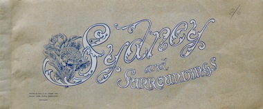 Lara RSL Sub Branch
Booklet, Sydney and Surroundings Win and Co Sydney, circa 1945
Photos from 1945 era include Sydney Harbour Bridge, Aerial View looking South East McMahon's Point, Aerial view of Sydney Harbour Bridge looking South West from over Neutral Bay. Top portion of the Bulli Pass. An Entrancing View of the South Coast, from Sublime Point. Government House, Sydney. Central Square Railway Station. Booklet from WW2 era that displays old photographs of the Sydney area circa 1945Sydney and Surroundings Win and Co Sydney containing eight double sided pages of photograph of the Sydney area.Front Cover - Sydney and Surroundings. In bottom left hand corner - Printed by Winn & Co. Sydney, for Murray Views, Gympie, Queensland. Copyright. At top right hand corner in pencil is the price 2/6 On Back Cover - Stamp - Tivoli Bookshop 335 Castlereagh St, Sydney - Books, Magazines, Stamps sydney, winn & company, murray views, gympie, queensland -
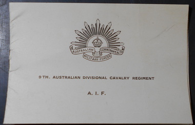 Bendigo Historical Society Inc.
Document - ANA COLLECTION: CHRISTMAS CARD SENT DEC 1941 FROM 9TH AUSTRALIAN DIVISIONAL CAVALRY REGIMENT A.I.F
Christmas card sent from the Middle East, Dec 1941 from Trooper J.A. Martindale, 9th Australian Divisional Cavalry Regiment A.I.F.; to "Fellow Members of the A.N.A. wishing you all A Merry Christmas and A Happy New Year" Two shhets of beige card a Christmas card front, with Australian Commonwealth Military Forces badge b central message, hand written from Trooper J.A. Martindale9th Australian Divisional Cavalry Regiment A.I.F. -
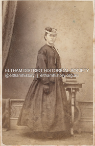 Eltham District Historical Society Inc
Photograph, Davies & Co, Believed to be Sarah Shillinglaw, c.1869
Sarah Shillinglaw was born at River Plenty on November 9, 1854. She married Charles Aldous on June 9, 1880 and died in Prahran, Victoria on August 3, 1925. Davies & Co (William Davies) operated from: 7 Bourke Street East 1867-1869 55 Bourke Street East 1874-1877 55 Bourke Street East as Central Photogrphic Studio (E. Sands Mgr) 1878-1884 73 Bourke Street East 1877 91 Bourke Street East 1864-1868 94 Bourke Street East 1864-1877 98 Bourke Street East 1860-1861 19 Collins Street East 1865-1868 5 Collins Street West 1866-1870 CARTE-DE-VISITE (cdv) 1857-1890 Cartes-de-visite (cdv's) are the most common form of photograph from the nineteenth century, generally measuring two and a half inches by four and an eighth inches (6.3 x 10.5 cm) when mounted, sepia toned, mounted on a card which was generally printed with the photographer's name and address on the back or beneath the portrait. - Frost, Lenore; Dating Family Photos 1850-1920; Valiant Press Pty. Ltd., Berwick, Victoria 1991marg ball collection, 1867-1869, 1869, davies & co post office photographic studio 7 bourke st east melbourne, paletot jacket, post office photographic studio, sarah aldous (nee shillinglaw 1854-1925), shillinglaw family photo album 2, unknown -
Federation University Historical Collection
Booklet, GIAE Official Opening, 1976, 11/1976
The Gippsland Institute of Advanced Education was established by an Order-in-Council in September 1968. On its establishment, the Institute assumed responsibility for the diploma coursed previously offered at Yallourn Technical College. In 1972 the Institute transferred part of its operations to the first of its permanent buildings on a large campus in rural surrounding near the township of Churchill, ten kilometres south of Morwell, and 160 kilometres east of Melbourne. The campus site plan report prepared in 1970 by the Institute's campus planners, Yuncken Freeman Architects Pty Ltd, provided the conceptual base for the development of a new campus at Churchill. All facilities were planned to converge on a central space; all having the ability to expand outwards. Central to the campus plan was the concept of an internal pedestrian street connecting all academic divisions to the central facilities. The first building was completed in 1972. The Administration Building, Visual Art & Maintenance Workshops, Multi-Purpose Building, and Student residences were designed by Yuncken Freeman Architects. The central Facilities Building (cafeteria and Union) were designed by Chancellor and Patrick, the Education Building and Applied Science Building is designed by Eggleston, McDonald and Secomb.Grey and yellow soft covered booklet prepared for the official opening of Gippsland Institute of Advanced Education.gippsland institute of advanced education, gippsland campus, churchill, m.w. hopper, c.h. ford, lindsay thompson, j.l. carrick, r.w. muncey -
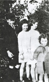 Surrey Hills Historical Society Collection
Digital image from a photocopy, Geoffrey, Beryl, Gwynne and Isabel Mair, c1924, Original: c1924
Dave and Lily Mair lived in East Melbourne after they married and Geoffrey, Beryl and Gwynne were born while they were there. Isabel may have been born in Mont Albert after they moved to Louise Avenue. This photo was probably taken at 20 Barton Street, Mont Albert. The children attended Mont Albert Central School. This is part of a large collection relating to the Deakin, Mair and Young families.A black & white image of 4 children in a garden setting; the boy is in school uniform.Rear in lead pencil: "The children of / Lily Vipond (nee / Deakin) / and David Millar (sic) Mair. / Geoffrey 1913-5.6.1970 / Beryl 1916-1976 / Gwynne 1917-1997 / Isabel 1921-1997 / Shirley Inez 1928-1968 / was not yet born at the / time of this photo." -
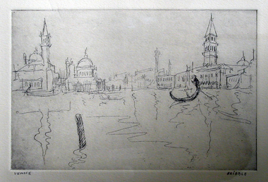 Federation University Art Collection
Printmaking - etching, 'Venice' by Bill Gribble, 2006
William (Bill) GRIBBLE (17.03.1928 - 2.06.2014) Bill Gribble received his artistic training at East Sydney Technical College, Central School fo Arts and Crafts London, and the Ballarat Technical Art School - a division of the Ballarat School of Mines (later Federation University Australia). This item is part of the Federation University Art Collection. The Art Collection features over 1000 works and was listed as a 'Ballarat Treasure' in 2007.Framed etching of Venice.art, artwork, bill gribble, venice, etching, printmaking -
 Bendigo Historical Society Inc.
Document - MCCOLL, RANKIN AND STANISTREET COLLECTION: LEASE RENTS BOOK, 1934/56
Book: Lease rents book. Green Cover with a red spine. Lease Rents Book + Half Yearly Meetings. South New Chum Syncline Gold Mine. Miners Rights etc. New Don NL. Castlemaine and other mining leases. Insurance details for South New Chum Syncline, East Clarence Gold Mine Co. NL, Central Nell Gwynne Gold Mine Co., NL and Monument Hill Gold Mine Co. NL.MCCOLL RANKIN & STANISTREETorganization, business, gold mining lease, mccoll rankin & stanistreet -
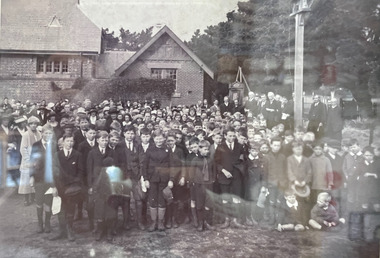 City of Moorabbin Historical Society (Operating the Box Cottage Museum)
Photograph - B/W Bentleigh SS No.2083, 1920
The Common School No. 213 East Brighton 1864 - 1878 replaced the original St Stephen's Church of England School in Tucker Road. 1878-1908 the School was known as Education Department State School No. 2083 Brighton East. 1908 - 1936 the School changed it's name to Bentleigh and then from 1936 - 1993 was known as East Bentleigh. 1993 the school was closed due to low enrollments and the building was demolished and land sold. Eric Hutchinson, the uncle of Les Hutchinson, attended this school. Eric is second row far left ' behind the boy with the white handkerchief '. The 1920 gathering may be for the unveiling of a World War 1 Honour Roll - for past students killed or injured - as can be seen at the back of the group A flag pole may be the central wood post as all the boys and men have removed their hats and caps. A school photograph of one of the original schools in the Bentleigh area showing a gathering of adults and children who had connection with this school either as teachers, pupils, parents or neighbours in 1920.A black & White photograph showing a group of adults and children in front of Education Department State School Bentleigh no. 2083 in 1920 (Reprint)education, st stephens anglican school east brighton, education department state schools, state school number 2083, coates charles j, hutchinson eric, hutchinson les, tucker road bentleigh, henry dendy special survey brighton 1841, market gardeners, dairy farmers, poultry farmers, early settlers, pioneers, tuck family bentleigh, moorabbin shire, moorabbin roads board, city of moorabbin, bent thomas -
 Ballarat Tramway Museum
Postcard - Folder set, Set of nine Black and white postcards, from drawings
Set of nine Black and white postcards, from drawings, contained within Reg. Item 2526, pages 4 and 6 of early Ballarat, glued or pasted into the book. A lot of the postcards have edge damage. Include Sturt St., Black Hill, Ballarat Fire Station, Central State School, Wesley Church and Botanical Gardens, Mechanics Institute, Benevolent Asylum, Orphan Asylum, Ballarat East Town Hall, Academy of Music. Date of drawings - prior to 1870's?. trams, tramways, ballarat, sturt st, fire station, schools, wesley church, mechanics institute, orphanage -
 Kew Historical Society Inc
Map, MMBW, MMBW Plan No.65 Kew & Heidelberg, 1900-1910
The Melbourne and Metropolitan Board of Works (MMBW) was established by an act of the Victorian Parliament in 1890 to prepare for and to implement a sewerage and water reticulation system across what was then inner Melbourne, its surrounding and middle distance suburbs, including Kew. The MMBW was disbanded in 1991.The map collection of the Kew Historical Society has at its core the historic maps assembled and originally stored in the City Engineer's Department of the City of Kew. These include maps in a number of scales. The vast majority of maps were produced by the MMBW in the first two decades of the twentieth century, and are solid working maps, backed by linen for durability. These maps are historically significant to Kew, the City of Boroondara and to the history of the development of state utilities in Victoria. A number of the Kew maps have additional details added by former municipal officers, including the levels reached by various floods. As these were working documents, information was added to them long after the period of their initial production and distribution.Early map of part of the Borough of Kew, created in the first decade of the twentieth century, at a scale 160 ft to 1 inch. The map covers what was then the south central part of Kew, bordered on its north by Malmsbury Street, in the west by Florence Avenue, in the south by Barkers Road, and in the east by Princess Street. The map shows the extent of urban development by that time, prominent institutions and the outlines of built structures in the municipality. Contour lines were added in ink to the map at a later stage.MELBOURNE AND METROPOLITAN BOARD OF WORKS / PLAN NO. 65 / KEW & HEIDELBERGmelbourne & metropolitan board of works, mmbw maps, mmbw plans, borough of kew, cartography -
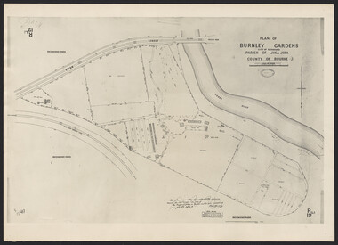 University of Melbourne, Burnley Campus Archives
Photograph - Plan of Burnley Gardens
"This plan is a copy of a copy of the survey made by Mr. Turner in 1926. The original plan and field notes are missing _ file Rs 3529" Signed by _signature unreadable_ -
 Bendigo Historical Society Inc.
Document - BENDIGO MINES - NOTES ON BENDIGO MINES
Handwritten notes and drawings of mines in Bendigo. Notes contain measurements of pulley wheels, poppet legs, engine houses, chimney and buildings. Mines mentioned are: True Blue Mine, Little 180, Alliance, East Clarence, North Virginia, Ironbark, Ironbark (Sheepshead), Hercules, Stanfield, Hercules No 1, Central Nell Gwynne, North Nell Gwynne, North Deborah, New Chum Syncline, Deborah, True Blue. Notes written by Albert Richardson. Reference A E Kennedy.gold mines, bendigo mines, notes on bendigo mines, a e kennedy, true blue mine, little 180, alliance mine, east clarence, north virginia, ironbark, ironbark (sheepshead), hercules, stanfield, hercules no 1, central nell gwynne, north nell gwynne, north deborah, new chum syncline, new south red white & blue, deborah mine, r g doble, windmill hill mine, true blue, lansell's little 180, south virginia -
 Melbourne Tram Museum
Document - Report, East Doncaster Progress Association, "East Doncaster Progress Association - Public Transport Survey - Report", mid 1960's
Report contained within a light brown card folder, containing many loose sheets, titled "East Doncaster Progress Association - Public Transport Survey - Report". About 50 pages, printed with a spirit duplicator. Not dated, possibly mid to late 1960's. Report stapled centrally along top edge., secured by a piece of adhesive tape. Includes comparisons between MMTB bus services and possible rail services. Section 2 - copy of questions on questionnaire, includes many comments.AETA stamp on front and inside sheet and "4E8" in ink on front cover.trams, tramways, doncaster, railways, mmtb, aeta -
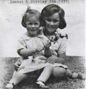 Surrey Hills Historical Society Collection
Digital image from a photocopy, Isabel and Shirley Mair, 1931, Original: c1931
These are the youngest two children of Dave and Lily Mair. Geoffrey, Beryl and Gwynne were born while they lived in East Melbourne. Isabel may have been born in Mont Albert after they moved to Louise Avenue. Shirley was born after they moved to 20 Barton Street, Mont Albert. The children attended Mont Albert Central School. Isabel Lillian (1921-1997) and Shirley Inez (1928-1968). This is part of a large collection relating to the Deakin, Mair and Young families.This is part of a large collection relating to the Deakin, Mair and Young families with many connections to Surrey Hills and Mont Albert.A black & white image of 2 young girls seated in a garden setting; the younger one is in the lap of the other and is holding a bunch of flowers.On a label adhered to the top of the original: "Isabel & Shirley Jan. 1931" Rear in lead pencil: "Isabel Lilian Mair / nursing her young sister / Shirley Inez Mair / 1931"isabel lillian mair, shirley inez mair, children -
 Kew Historical Society Inc
Map, MMBW, MMBW Plan No.67 Kew, 1900-1910
The Melbourne and Metropolitan Board of Works (MMBW) was established by an act of the Victorian Parliament in 1890 to prepare for and to implement a sewerage and water reticulation system across what was then inner Melbourne, its surrounding and middle distance suburbs, including Kew. The MMBW was disbanded in 1991.The map collection of the Kew Historical Society has at its core the historic maps assembled and originally stored in the City Engineer's Department of the City of Kew. These include maps in a number of scales. The vast majority of maps were produced by the MMBW in the first two decades of the twentieth century, and are solid working maps, backed by linen for durability. These maps are historically significant to Kew, the City of Boroondara and to the history of the development of state utilities in Victoria. A number of the Kew maps have additional details added by former municipal officers, including the levels reached by various floods. As these were working documents, information was added to them long after the period of their initial production and distribution.Early map of part of the Borough of Kew, created in the first decade of the twentieth century, at a scale 160 ft to 1 inch. The map covers what was then the north central part of Kew, bordered on its north by the Outer Circle Railway Spruzen and Beresford Avenues, in the west by Princess Street, in the south by High Street, and in the east by (about) Belford Road. The map shows the extent of urban development by that time, prominent institutions and the outlines of built structures in the municipality. Contour lines were added in ink to the map at a later stage.MELBOURNE AND METROPOLITAN BOARD OF WORKS / PLAN NO. 67 / KEW melbourne & metropolitan board of works, mmbw maps, mmbw plans, borough of kew, cartography