Showing 1020 items
matching collection point
-
 Eltham District Historical Society Inc
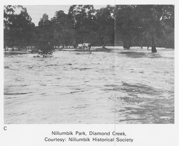
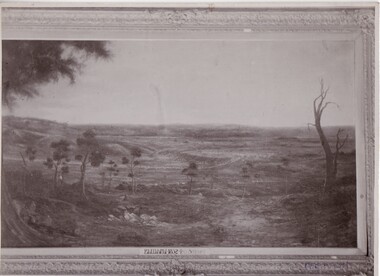
Work on paper (Sub-Item) - Photograph, Nillumbik Park, Diamond Creek
... on a high point. Nillumbik Historical Society collection... on a high point. Nillumbik Historical Society collection flood ...Undated black and white photograph of the Diamond Creek in flood, Nillumbik Park, Diamond Creek. Cattle take refuge on a high point. Nillumbik Historical Society collectionflood, diamond creek, nillumbik historical society -
 Eltham District Historical Society Inc
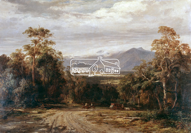
Photograph, "On the Woods Point Road" - Louis Buvelot, 1872, 1971
Reproduced pages 2-3 of Pioneers & Painters, edited by Alan Marshall (1971) Source: Geelong Art Gallery; purchased by the Trustees, 1949This photo forms part of a collection of photographs gathered by the Shire of Eltham for their centenary project book,"Pioneers and Painters: 100 years of the Shire of Eltham" by Alan Marshall (1971). The collection of over 500 images is held in partnership between Eltham District Historical Society and Yarra Plenty Regional Library (Eltham Library) and is now formally known as the 'The Shire of Eltham Pioneers Photograph Collection.' It is significant in being the first community sourced collection representing the places and people of the Shire's first one hundred years.4 x 5 inch colour reversal film (2) Condition: May not be true to colour of original work. Scanned from a 4 x 5 inch colour transparency which was taken c.1970 (approx. 50 years old) and which has undergone significant colour degradation towards the red spectrum. Allowances made for colour cast correction in scan with best guess for white balance. Significant light flare is reflected off glossy surface of original work at camera lens at lower left and right sides causing quality issues. artist, pioneers and painters, sepp, shire of eltham pioneers photograph collection, warburton, louis buvelot -
 Ballarat Clarendon College
Book
Twenty-five books donated by old collegian Francis Tweedie and possibly his sister Miss E M Tweedie. Francis Tweedie entered Ballarat College in 1889. He was the son of Mrs Tweedie 60 Doveton St, and attended with his brother Alec. The school holds no record of Miss E M Tweedie's attendance. Some of the books contain the signatures of Andrew Anderson and May Anderson. Their connection to the donors is unknown at this point. Example of ongoing old collegian support of school. The Weatherly Library was opened in 1936 and its collection significantly established by donation or bequest of old collegians.Twenty-five books variously titled and sized including The History of England (8 vol) , Taine's History of English Literature (2 vols), and Hallam's History of England (3 vols)Book plates inside front cover: Ballarat College Library / PRESENTED BY / Miss E M Tweedie and Mr F Tweedie / 1947.... Illustrated book plate inside cover of 'Longfellow's poetical works': Weatherly Library / Ballarat College / Miss E Tweedie / Mr F Tweedie 1947e-m-tweedie, francis-tweedie, weatherly-library, ballarat-college, andrew-anderson, may-anderson -
Federation University Historical Collection
Photograph, Ballarat Teachers' College Students at Ricketts Point, 1949, 1949
Black and white photographs of Ballarat Teachers' College Students at Ricketts Point, 1949. .1) L-R Merle Williams, Marg Ransome, Mary Bilton, Shirley Down, Helen Veitch, Rita Rowland, Barbara Young. 2.) L-R Helen Veitch, Marg Ransome, Mary Bilton, Lois Cheetham, Shirley Dawn, Mr Burns, Rita Rawland, Barbara Younghelen veitch, marg ransome, mary bilton, lois cheetham, shirley dawn, mr burns, rita rawland, barbara young, ballarat teachers' college, ricketts point, merle williams, shirley down, rita rowland -
 Bendigo Military Museum
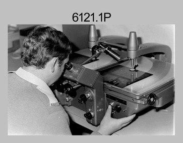
photograph - Aerotriangulation Production – Army Survey Regiment, Fortuna, Bendigo, c1980
This collection of five photos was most likely taken in 1980. Wild PUG4 point transfer devices were used by technicians in Air Survey Squadron to stereoscopically view the photography containing the survey control points and the mapping aerial photography. The Control points were transferred from the control photography to the mapping diapositives of aerial photography by drilling their locations into the photographic emulsion. The Zeiss (Jena) Stecometer analytic stereocomparator for air photography was introduced at Air Survey Squadron in 1963. Aerotriangulation production was expedited using computers for analytical photogrammetric processes. The technician accurately measured between pass, tie, and survey control points on aerial photographs.Air Survey Squadron Aerotriangulation Section - Army Survey Regiment, Bendigo. c1980. This is a set of five photographs of Air Survey Squadron personnel operating aerotriangulation equipment at the Army Survey Regiment at Fortuna, Bendigo, c1980. Photographs .1P to .4P are on 35mm negative film and were scanned at 96 dpi. Black and white photo .5P is on photographic paper and was scanned at 300 dpi. They are part of the Army Survey Regiment’s Collection. .1) - Photo, black & white, c1980, Wild PUG4 point transfer device, unidentified technician. .2) - Photo, black & white, c1980, Wild PUG4 point transfer device, unidentified technician. .3) - Photo, black & white, c1980, Wild PUG4 point transfer device, unidentified technician. .4) - Photo, black & white, c1980, Zeiss (Jena) Stecometer, unidentified technician. .5) - Photo, black & white, c1980, Zeiss (Jena) Stecometer..1P to .5P No personnel are identified.royal australian survey corps, rasvy, army survey regiment, army svy regt, fortuna, asr, air survey, aerotrig -
 Bendigo Military Museum
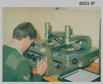
Photograph - Army Survey Regiment Map Production Equipment, c1980s, c1990s
Photos .1P, .2P, and.4P were most likely taken in the 1980s and photos .3P, .5P to .7P in the c1990s at the Army Survey Regiment, Fortuna, Bendigo. Despite lacking annotation on exact dates, locations and personnel, they are positively identified. CPL Ian Nelson in photo .1P is operating a Wild Pug 4 point transfer device in Air Survey Squadron c1980s. Control points were transferred onto the mapping diapositives of aerial photography by drilling their locations into the photographic emulsion. SPR Viv (Hawkins) Doherty in photo .2P, SPR Jeanette Drury-Lane in photo .5P and SGT Sandy Craig are operating a Wild B8 Stereoplotter coupled to a digital workstation in Air Survey Squadron c1994. Topographic features were extracted with the B8 in 3D and feature coded with attributes, using keyboard, menu, keypad and voice inputs to the computer. The features were stored in the AUTOMAP 2 digital database for subsequent cartographic production and printing. CPL Mick Ellis in photo .3P is operating the Optronix 4040 Scanner/Film Writer in Lithographic Squadron c1990s. In scanning mode, compilation sheets were mounted on the drum and scanned. The resultant raster file was vectorized, feature coded with attributes and stored by cartographic technicians in the AUTOMAP 2 database. In film writing mode, digital cartographic files were output at very high resolution for each print colour on photosensitive film, for subsequent finalisation, platemaking and printing.This is a set of seven photographs of technicians operating map production equipment at the Army Survey Regiment, Bendigo. The photographs were printed on photographic paper and are part of the Army Survey Regiment’s Collection. The photographs were scanned at 300 dpi. .1) - Photo, colour, c1980s. CPL Ian Nelson operating a Wild Pug 4 point transfer device in Air Survey Squadron. .2) - Photo, colour, c1980s. Wild B8 Aviograph stereoplotter feature extraction, SPR Viv (Hawkins) Doherty in Air Survey Squadron. .3) - Photo, colour, c1990s. CPL Mick Ellis operating the Optronics 4040 Scanner in Lithographic Squadron. .4) - Photo, colour, c1984. AUTOMAP 2 Graphic Edit Workstation, SPR Craig Kellet in Cartographic Squadron. .5) - Photo, colour, c1994. Wild B8 Aviograph stereoplotter feature extraction, SPR Jeanette Drury-Lane in Air Survey Squadron. .6) - Photo, colour, c1994. AUTOMAP 2 Graphic Edit Workstation, L to R: unidentified, SPR Rachel (Stanford) Scott, CPL Chris Wynn in Cartographic Squadron. .7) - Photo, colour, c1994. Wild B8 Aviograph stereoplotter AUTOMAP 2 Graphic Edit Workstation, L to R: unidentified (x2), SGT Sandy Craig in Air Survey Squadron..1P – no annotations .2P – annotated “Stereoplotter Workstation. The operator has the use of keyboard, menu, keypad and voice for input to the computer. Feedback is given through voice and screen messages.” .3 to .7P – no annotationsroyal australian survey corps, rasvy, army survey regiment, army svy regt, fortuna, air survey, litho, aerotrig, automap 2 -
 Bendigo Military Museum
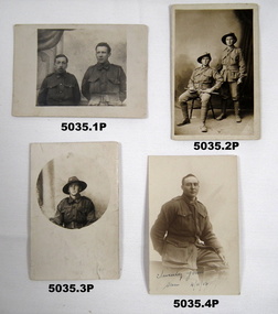
Photograph - PHOTOGRAPHS 38th BN, 1917 - 18
... , no details at this point. Cards in the collection relating to Edgar..., no details at this point. Cards in the collection relating to Edgar ....1) Cpl Anderson. Possibly Thomas Anderson No 806 C Coy, KIA 7/9th June 1917. Sgt Rowling. Possibly Walter Liscombe Rowling No 981 C Coy, KIA 4.10.17. .2) The card is written by Edgar Stanbury MM to his mother, in it he states the two names of the soldiers in the photo, Percy Bull, Joe Carter. Details are Percy Robert Bull No 833 C Coy, Joseph Leslie Carter No 842 C Coy. .3) Sgt. Francis Ramsdale MM, No. 668, 37th Battalion. .4) Sam, no details at this point. Cards in the collection relating to Edgar Stanbury MM, refer Cat No 5032.3P for his details.Post card photos sepia and B &W colour, soldiers in uniform in studio background.. .1) On left soldier short with Cpl stripes, on right soldier with Sgt stripes. .2) On left soldier sitting with crop, on right soldier standing. .3) In round shape soldier with L/Cpl stripe.. 4) Soldier sitting astride a bench. All photos have hand writing on..1) “Cpl Anderson, Sgt Rowling”. .2) “Re ...... 18.7.17 In field 6 June 1917, Dear Mother” .3) “Now a Sergeant, Ramsdale in the 37th Battalion”. .4) “Sincerely yours, Sam 4.11.18”photographs, c coy 38th bn -
 Bendigo Military Museum
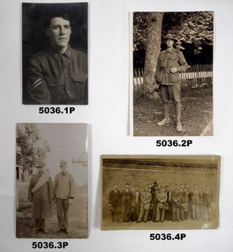
Photograph - PHOTOGRAPHS 38th BN, 1916 - 1918, post war
.1) Albert Ladlow No 1865 C Coy 2nd reinforcements. .2) Jack Grinton No 1043 C Coy, refer Cat No 1280 for service details. .3) Soldiers unknown at this point. .4) Group photo. 38th BN men C Coy. Three are recognisable, front centre Frederick Lehmann MM No 1048 C Coy, rear 4th from right Edgar Stanbury MM C Coy, 2nd from right Dick Verso C Coy. Items in the collection re Edgar Stanbury MM, refer Cat No 5032.3P Two Post card photos 1sepia 1 B&W soldiers in uniform, 1 sepia tone single soldier, 1 sepia group photo. .1) Portrait photo soldier with CPL stripes. .2) Soldier in gardens holding a camera. .3) Two soldiers standing with buildings in background. .4) Group photo post war 15 men in civvies against a brick wall background..1) On rear, “Cpl Albert Ladlow C Coy of Horsham Vic, 25.10.18 at present in Blighty, was Gassed” .2) on front, “4133, T.L.Fuller Amesbury”photographs, c coy, 38th bn -
 Bendigo Military Museum
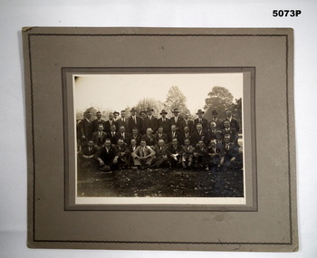
Photograph - PHOTOGRAPH 38th BN, Post 1920
The photo was taken Post WW1 and believed to be 38th Bn men, non identifiable at this point. It was in a collection relating to the 38th Bn Social Club Melbourne.Photo on heavy grey card with two ornate black edgings, there are 37 men in 3 rows in a park setting.photographs, 38th bn, -
 Bendigo Military Museum
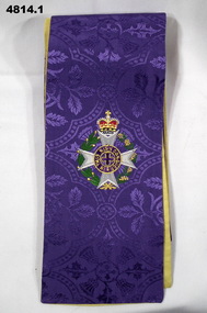
Ceremonial object - RELIGIOUS STOLES, Church Stores
Part of the Reverend Chaplain Major Thomas B Williams No 556101 Collection.Set of four religious stoles in four different colours (purple, white, green and red), representing four Christian liturgical seasons. Each is constructed in a similar manner. The fabric for each is silk damask with thistle patterning and a plain fabric lining. Each has two embroidered crests consisting of a grey Maltese cross ringed by a gold and green floral wreath and topped with a queen's crown. the mid point of each has a gold embroidered Maltese cross. .1) Purple damask with yellow lining. .2) White damask with a white lining. .3)Green damask with a yellow lining. .4) Red damask with a yellow lining..1), .3) and .4) - Inside middle - Supplier's name on a white tag with yellow lettering: 'Church Stores, Sydney, Brisbane'.army chaplains, personal equipment, major thomas b williams -
 Bendigo Military Museum
Letter - LETTER 1916, C.1916
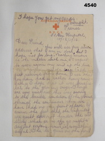
The letter gives a graphic description of the front line and is signed of with just “Will”, a number with 4 digits is under this, possibly a Regt No but it does not match up with anyone re the date on the letter. Letter in the collection relating to A.G Ferris No 2156 AIF, refer Cat No 4183.3P for his service details.Letter, “Australian Branch of the Red Cross”, letter head in red, hand written in black pencil, dated, double sided.main point. “France, 51st Gen Hospital 10/12/1916”, “Dear Friend”letters, red cross -
 Federation University Historical Collection
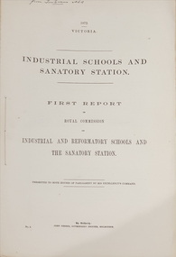
Booklet - Report, John Ferres, Government Printer, Royal Commission on Industrial and Reformatory Schools and the Sanatory Station, 1872 and 1874
The Industrial Schools and Quarantine Station Royal Commission took place in 1872, with the final report published in 1874..1) First report of the Royal Commission on Industrial and Reformatory Schools and the Sanatory Station. 65 pages. .2) Second and final report of the Royal Commission on Industrial and Reformatory Schools and the Sanatory Station. 16 pages. This report included defects in the system and recomendations.On front cover "From Tom Evans MLA"quarantine, industrial schools, reformatory schools, royal commission, gavin duffy, st kilda road industrial school, industrial schools commission, red hill philanthropic school, flat islands port phillip bay, pauper children, johanna margaret hill, american industrial schools, cuthbert fox, james walker, pilot schooner rip, captain h.h. o'neil, william mccrae, t.m. girdlestone, william austin zeal, j.a. panton, industrial schools and quarantine station royal commission, quarantine station point nepean, sanatory station, queenscliff, point nepean, philanthropic school red hill, rip, george ferguson bowen, orphan asylums -
 Federation University Historical Collection
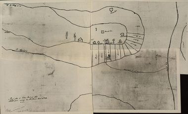
Photograph - Black and White Photograph, Rough Plan of Golden Point in 1851
A photograph compilation of a Rough Plan of Golden Point in 1851. "Rough Plan of Golden Point in 1851. sketched from memory by Thos Dunn March 16th 1870." golden point, ballarat, thomas dunn, cavanagh's claim, bickett's party, o'connor, hammond, greenwood, gold discovery -
 Bendigo Military Museum
Photograph - PHOTOGRAPHS WW1, 1917 onwards
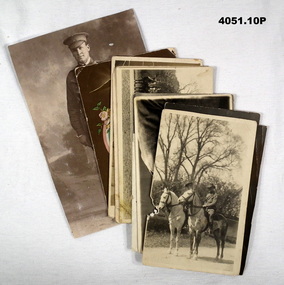
The collection revolve around Laurence Edward (Larry) O'Connor No.2508, enlisted 2.4.1917 in 21st Reinforcements, 13th Light Horse, embarked for England 21.11.1917. .1) On rear "Heap of Love 7 Kisses, In the best of health Larry". Another address on rear in "2515 TRP I.H. Westaway 18 Kinkorra road Hawthorn Vic" enlisted 3.8.1917 21st Reinforcements 13th L.H. Regt. embarked 21.11.1917 for England. .2), .3) & .4) All are "Larry O'Connor" on rear of .3) "8.11.17 To Mrs Ryan with best wishes from Linnie" .5) on front written in pencil "Uncle Larry" with arrow pointing to him. on rear "to Linnie with Love from Larry Dec 23.12.1918". across the top "??? Belgium " .7) On rear "To Linnie with best wishes Larry" "Taken in Glasgow June 28.6.1918" Larry is on the left of photo. .8) On the rear in pen "Your aff brother Larry" "Taken in Glasgow June 28.6.1918" Larry is on the left of photo. .9) One rear in pen - letter to "Dear Sister France Oct 23/1918" signed off "Your affectionate brother Larry". .10) Photo is Laurence (Larry) O'Connor..1) Postcard photo, black & white, two men on horseback, trees in the background. Brief letter on rear in pencil and ink. .2) Postcard photo, black & white, soldier sitting, wearing a cap, background clear. .3) Postcard photo, sepia tone, same as .2) but with brief note on rear in pen and pencil. .4) Postcard photo, black & white, portrait of a soldier in great coat and peak cap. .5) Postcard photo, black & white, three rows of soldiers, 24 in total in front of a building. .6) Postcard photo, black & white, 17 soldiers on horseback lined up in a row, trees in background. .7) Postcard photo, sepia tone, portrait of two soldiers in slouch hats. .8) Postcard photo, sepia tone, portrait of two soldiers without hats. .9) Postcard photo, colour, eagle at top, centre has oval frame with soldier centre, American, brown background, writing at bottom. .10) Photo, black & white, soldier standing with bandolier, peak hat, holding a crop.photographs, postcards, larry, 13th lh -
 Bendigo Military Museum
Photograph - HOSPITAL PHOTOGRAPHS, Originals 1915, 1916
The photos relate to a collection re Robert O’Donahoo No 1399 AIF WW1. Refer Cat No 1500 for his service history. .1) Robert is the soldier with the arrow pointing down to him. On the rear of the card is a letter to his Mother which appears to be dated Oct 22nd 1915. He tells his mother about a 2nd operation on his leg that was amputated. Sister West is the Nurse behind him and the other is Sister Raymond. .2) The Hospital where Raymond was admitted to in England. .3) On the rear of the Post card in pen, “twin Sisters UREN who were on the Hospital ship Thermistocles on the way home in 1916, they lived in Adelaide. .4) Robert O’Donahoo is the Soldier standing on the left, on the rear of the photo in blue pen, “Caulfield Hospital 1916” The twin Sisters were Catherine Temby UREN, Amelia UREN. Robert had some 15 operations on his leg then a further 3 to correct the position of his leg which is evident in .1).1) Photo Post card, copy of original, B & W showing 4 wounded soldiers, 2 Nurses and possibly 2 Orderlies outside a hospital Ward. .2) Photo Post card, copy of original, view of a large Hospital area complex. .3) Photo Post Card, copy of original, B & W, 2 Nurses sitting on deck of a ship. .4) Photo Post Card, copy of original, sepia tone showing 4 soldiers, 2 standing with walking sticks, 2 sitting’photography, hospitals nurses, military ww1 -
 Bendigo Military Museum
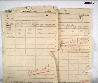
Document - MESSAGE FORMS, 7.11.1942
Message forms (RAAF Form A22) relate to training flights. Part of the Frederick Gardner Davey DFC No 410533 RAAF collection. Refer Cat No 3536P for his service details..1) & .2) Foolscap size pro for a printed in black ink, hand written details front and back in red and grey lead pencil..1) hand written details of flight from, “Point Cook to Cootamundra - Mascot”, signed by “F.G.Davey” .2) Hand written details of flight from, “Mascot to Cootamundra - Point Cook”, signed by “F.G.Davey”message forms, training flights, raaf -
 Bendigo Military Museum
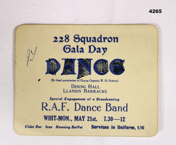
Flyer - CARD, GALA DANCE, Post 1943
228 Sqd RAF was a Sunderland Flying Boat Sqd during WW2. Item in the collection of Reginald Charles Allardice No 418557 RAAF. Refer Cat No 3627.5 for his service details.Soft card, square with round corners with printed details in dark blue relating to an upcoming RAF Gala Dance put on by 228Sqd for Mon 21st, 7.30 - 12 at the Dining Hall LLanion BarracksMain point, “By kind permission of Group Captain W.H.Hutton”dances, raf, ww2 -
 Federation University Historical Collection
Article - Article - Women, Ballarat Teachers' College: Women of Note; Monica Miller, (1900-1995)
Monica Miller was taught to sing by Ballarat Teacher Madame Warburton, and in her youth competed as a singer in Ballarat, Bendigo and Geelong. She received her early musical training in piano, violin and singing at Ballarat's Loreto College. Monica Miller was runner up in the Sun Aria, coming second by one point. In 1946 she started lecturing at Ballarat Teachers' College (BTC) in a few rooms at the back of Dana Street State School, and retired from the Gillies Street Teachers' College site in 1965. Speech Training was also the domain of Monica Miller at BTC. Her Speech Training class notes include: Voice, Articulation parts, Correct positions for consonants, vowels and diphthongs, Phonetic Styles, Correction of Speech Defects, Speech Training in the schools, Poetry Appreciation, Rhythm, Lessons for country classes, Lessons for Student Teacher Classes and Lessons to Grades. Monica Miller died on 25 February 1995. women of note, monica miller, madame warburton, competed in singing, ballarat, bendigo, geelong, sun aria, ballarat teachers' college, btc, dana street state school, gillies street, speech training, 1946-1965, poetry appreciation, rhythm, phonetic styles, correction of speech defects -
 Federation University Historical Collection
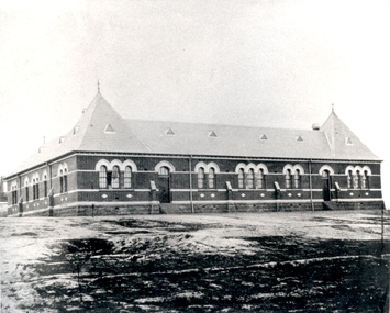
Photograph - black and white, Golden Point State School, Ballarat
Photograph of a brick building known as Golden Point Primary School.education, school, golden point primary school -
Federation University Historical Collection
Geological specimen
geology, rocks, sap hill cemment, golden point ballarat cement -
Federation University Historical Collection
Tool - Ethnographic Material, Pirri Points
Six pirri points made out of stone. A pirri point is a small stone point, trimmed on one surface, generally used as a spear tip. It is a leaf shaped point.aboriginal, stone, tool, spear, pirri point -
 Federation University Historical Collection
Photograph, Ballarat 1852
Photograph of a framed oil painting titled 'Ballarat 1852 Tent Settlement from Black Hill. Shows Ballarat Flat, Golden Point township. Black Hill Flat and Sebastopol.ballarat, black hill, golden point, ballarat flat, tents, settlement, black hill flat, sebastopol -
Federation University Historical Collection
Book, Donald Douglas Mather, Diary 1968
Red hard covered Norman Diary 1968. Daiiy happenings, historical notes (especially on gold), Ballarat, Gold Discovery, golden point gold monument.gold, gold discovery, gold monument, golden point -
 Bendigo Military Museum
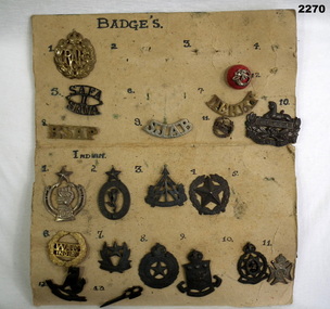
Badge - BADGE COLLECTION MOUNTED, C.WW2
Items in the collection re Ian McLeod RWAFF, refer Cat No 2262.2 for service details.Panel One only, a lot of Indian badges. .1) RAF badge .2), .3), .4) .6) missing .5) SAFA 11 SAVA .7) Derby .8) RSAP .9) SJAB .10) Gloucestershire, Eygpt with Lion .11) Eygpt, Lion, Surronded by oak leaf cluster .12) Red button badge, with a bugle and K R motif over it Panel Two .1) Circular badge .2) Indian signals corps badge. oval shape surmounted with 5 pointed star .3) Indian reconaisance corp badge symbolic tree and arrow .4) Indian engineers badge. 5 point star surrounded by oak leaf cluster .5) Missing .6) WAC India .7) Indian intelligence corps. 5 pointed star .8) Indian electrical and mechanical engineers badge .9) Indian army ordinance badge .10) Indian army medical corps .11) Symbolic cross .12) Burma intelligence corps .13) Stylised trench raid weapon Panel Three .1) Crossed khukris .2) Cross khukris .3) Simple doughnut shaped ring .4) Doughnut shaped ring. surmounted by a crown in center is letters X1 .5) JAT Regiment badge large letters IX surmounted with a crown .6) Regiment cluster of leaves .7) Madras regiment badge .8) Unknown 4 sort of legs surrounded with a crown .9) Dogras Regt. In the centre are the number 17 surmounted with a crown .10) Punjab regt. Center is a 5 pointed star with numbers 14 surmounted with a crown .11) Missingbadges, collection, indian -
 Bendigo Military Museum
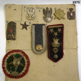
Banner - BADGE COLLECTION MOUNTED, C.WW2
Items in the collection re Ian McLeod RWAFF, refer Cat No 2262.2 for service details.1 Badge silver inscription and crowned eagle. gold anchor and chain in centre. 2 Badge silver bottom half is a shield top half is a crowned eagle with wings outstretched. 3 Badge gold square on a gold square off set 45 degrees in centre is a lion the rear surrounds are two crossed swords. 4 Copper badge of an eagle with large crown there is an enamel white cross in centre of a red enamelled oval the birds claws are holding a lanyard. 5 Copper shield with cross rifles in it there is numbers 64 in red enamel circle in centre a crown is between. 6 Plain star 5 point 3 cm wide 7 grey cloth silver engine the bottom has British coat of arms. 10 cm x 5 cm. 8 Uniform. Black cloth rad binding has gold 3 pips, crown with red cross. crown gold thread. copper button. 9 Cloth rosette green centre white red surrounds 5 pointed brass star number 9 in centre surmounted with a crown.badges, collection, foreign -
Federation University Historical Collection
Document, Ballarat's Irish Lawyers, c2000
22188Folder of research notes on early Ballarat Lawyers of Irish origin, including Woods Point, Philip D. Hardy, Hardy Brothers, Joseph Hardy, John Hardy, Leonard Hardy, Richard Ford, Agar Lynn, Adam Loftus Lynn, Richard O'Cock, Ballarat Volunteer Rifle Regimentdianne campbell goldfields lawyers collection, lawyers, ballarat, legal, woods point, philip d. hardy, hardy brothers, joseph hardy, john hardy, leonard hardy, richard ford, agar lynn, adam loftus lynn, richard o'cock, ballarat volunteer rifle regiment -
 Footscray Community Arts
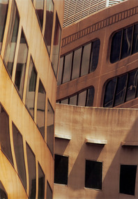
Converge - Collins Street Window Reflection, Greg Considine, 2005
MEDIUM: Photographic print. DESCRIPTION: A photograph of abstract architecture. Black outer frame with glass front panel and white board inner frame. An abstract collection of building faces meeting towards a left off centre vertical line collision point. This picture is a meeting of mirrors, how many remains a mystery. Where one mirror or building starts and another ends, to the viewers eye is met with some uncertainty. Following lines, the clearest meeting of mirrors is where the building on the left appears to be the same and collides with a variety of other buildings coming horizontally in a distinct vertical line to the top of the image. The bulidings on the right have somehow through the skill of the photographer captured a bermuda triangle of walls. The mirroring angles of the walls being from either several different buildings, or from several different mirrors. This creates a strange collecetion of imagery, the viewer unable to make clear distinctions of where something starts or ends or from where it is coming from. The tonal shades and shadows created also play a role in creating an interesting collage of shapes and lines. This piece essentially speaks of lines, angles, geometric shapes, meeting points, shadow and light. Signed and dated on white board inner frame, directly under left corner of image.photograph, st, considine, converge, collins -
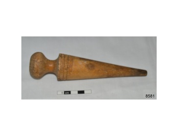 Flagstaff Hill Maritime Museum and Village
Tool - Proddey, Early 20th century
This wooden proddey has a rounded handle and a cone shape with a point at the bottom. It is used for making rag rugs. The wood is discoloured at the pointed end, indicating that is has been used. The tool is part of the W.R. Angus Collection. Traditionally, in the 18th and 19th centuries, rag rug making was a domestic craft. Old or worn-out fabrics and clothing would be cut into strips then proddey would be used to poke the strips through a woven backing fabric. The fabrics were re-purposed and the rugs provided warmth or protected the floors from fluids or dirt.The proddey is an example of a tool used for rag rug making, in the 18th and 19th centuries. The handcraft returned to popularity in the early 20th century. W.R. Angus Collection is significant for still being located at the site it is connected with, Doctor Angus being the last Port Medical Officer in Warrnambool.Proddey; teardrop or conical shape, light-coloured wood, used for rag rug making. Tool has a rounded handle and is decorated with two scored lines around the top of the cone. Part of the W.R. Angus Collection. Dr Angus lived and worked in Warrnambool with his family from the 1930s to the 1960s. He was the last doctor to pe appointed as a Port Medical Officer. He and his wife were actively involved in the local community. He enjoyed several pastimes, such as billiards, weaving, pastel drawing and rag rug making.warrnambool, shipwreck coast, flagstaff hill, flagstaff hill maritime museum, flagstaff hill maritime village, hand craft, homemade, rag rug, rug making tool, proddie, recycled fabric, cottage craft, 18th century, 19th century, handmade, floor mat, mat, rug, w.r. angus, craft, handcraft, recycle -
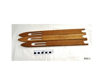 Flagstaff Hill Maritime Museum and Village
Tool - Netting Shuttle, Early-to-mid 20th century
Maritime trades included making and mending nets. Netcraft skills have been taught and applied for centuries and are ongoing. Shuttles, or net needles, are used in the netting process, along with twine or cord, and a sharp knife or scissors. The twine is wound onto the shuttle and dispensed as the shuttle knots and weaves the cord to make the net. These shuttles are lightweight, compact and portable too. Nets were used on sailing ships for the crew's safety, often saving the sailor's lives in stormy seas Examples are the ship mast nets or shrouds that are wide at the base on the deck and taper to a point at the top of the mast, and railing nets that encircle the rails around the deck and prevent people and objects from rolling or falling into the sea. The shuttles were donated to Flagstaff Hill Maritime Village by the family of Doctor William Roy Angus, Surgeon and Oculist. It is part of the “W.R. Angus Collection” that includes historical medical equipment, surgical instruments and material belonging to Dr Edward Ryan and Dr Thomas Francis Ryan, (both of Nhill, Victoria) and Dr Angus’ own belongings. The Collection’s history spans the medical practices of the two Doctors Ryan, from 1885-1926 plus that of Dr Angus, until 1969. Nets were an essential part of the life-saving safety equipment on sailing vessels. The set of netting shuttles is an example of net-making tools used in the 18th to 20th centuries and continues into modern times to create and repair safety equipment. The shuttles are part of the W.R. Angus Collection, which is significant for still being located at the site it is connected with, Doctor Angus being the last Port Medical Officer in Warrnambool. Shuttles, set of three; wooden slats, one end pointed, the other a concave shape. The centre is cut-out, leaving a straight tab in the centre lengthwise. The set is part of the W.R. Angus Collection. warrnambool, shipwreck coast, flagstaff hill, flagstaff hill maritime museum, flagstaff hill maritime village, net making, net mending, net shuttle, net making tool, maritime trade, darning, shuttle, tool, 20th century, w.r. angus, weaving, netting shuttle, net craft, net needles, safety nets, safety equipment -
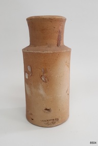 Flagstaff Hill Maritime Museum and Village
Container - Earthenware jar, Bailey & Co, circa 1878
The handmade earthenware jar was one of a group of artefacts in the McCulloch Collection that were recovered from the shipwreck Loch Ard. The jar could have been from the ship's cargo or personal effects. There are other jars in our collection that were recovered from the Loch Ard. The object is now one of the shipwreck artefacts in Flagstaff Hill’s Mc Culloch Collection, which includes items recovered from the wrecks of the Victoria Tower (wrecked in 1869) and Loch Ard (wrecked in 1878). They were salvaged by a diver in the early 1970s from the southwest coast of Victoria. Advanced marine technology had enabled divers to explore the depths of the ocean and gather its treasures before protective legislation was introduced by the Government. The artefacts were donated to Queensland’s Department of Environment and Heritage Protection (EHP) by a passionate shipwreck lover and their locations were verified by Bruce McCulloch. In 2017 the Department repatriated them to Flagstaff Hill where they joined our vast collection of artefacts from Victoria’s Shipwreck Coast. The Loch Ard: - The three-masted, square-rigged iron ship Loch Ard belonged to the famous Loch Line which sailed many ships from England to Australia. The ship was built in Glasgow in 1873. The Loch Ard made three trips to Australia and one trip to Calcutta before its final voyage. The Loch Ard left England on March 2, 1878, under the command of Captain Gibbs, bound for Melbourne with a crew of 37, plus 17 passengers and a load of cargo. The general cargo included straw hats, umbrellas, perfumes, clay pipes, pianos, clocks, confectionery, linen and candles, as well as a heavier load of railway irons, cement, lead and copper. There were items included that were intended for display in the 1880 Melbourne International Exhibition, including the famous Loch Ard Peacock. On June 1, 1878, Captain Gibbs was expecting to see land but visibility was reduced by fog. As it lifted, the sheer cliffs of Victoria's west coast came much closer than expected. The captain was unable to steer away and the ship struck a reef at the base of Mutton Bird Island, near Port Campbell. The top deck was loosened from the hull, the masts and rigging came down and knocked passengers and crew overboard, and even the lifeboat crashed into the side of the ship and capsized. Of the 54 people on board, only two survived: the apprentice, Tom Pearce and the young woman passenger, Eva Carmichael. The well-packed Minton porcelain peacock also survived, safe inside its crate. Much of the cargo was washed up, smashed and broken, and some was salvaged. Other cargo is still with the wreck at the base of Mutton Bird Island, now protected by Government law. The artefact is an example of cargo or personal items on board a ship in 1878. It provides a reference point for classifying and dating similar items. This artefact is significant for its association with the sailing ship Loch Ard, one of the best-known, and one of the worst, shipwrecks in Victoria’s history. Flagstaff Hill’s collection of artefacts from Loch Ard is significant for being one of the largest collections of artefacts from this shipwreck in Victoria. It is significant for its association with the shipwreck, which is on the Victorian Heritage Register (VHR S417). The collection is significant because of the relationship between the objects, as together they have a high potential to interpret the story of the Loch Ard. The Loch Ard collection is archaeologically significant as the remains of a large international passenger and cargo ship. It is historically significant for representing aspects of Victoria’s shipping history. Container, round brown earthenware jar with a wide mouth, thick lip, a wide neck that tapers slightly inwards towards the shoulder, and a body that tapers slightly inward towards the base. The glazed surface is rough. The variegated colours of the clay also has small dark speckles. There are several chips and dents on the jar. The inscription is stamped into the lower edge. Made by Bailey & Co., England. Recovered from the wreck of the Loch Ard.Inscription “Bailey [&] Co / ENGLAND” flagstaff hill, warrnambool, flagstaff hill maritime museum, maritime museum, shipwreck coast, flagstaff hill maritime village, great ocean road, white star line, victorian heritage register, sailing ship loch ard, loch line, loch ard, captain gibbs, eva carmichael, tom pearce, glenample station, mutton bird island, loch ard gorge, migrant ship 1878, cargo ship 1878, stoneware jar, domestic container, kitchenware, kitchen storage, bailey & co england, shipwreck artefact, wreck dive, mcculloch collection, bruce mcculloch, 1878, sailing ship, earthenware, stoneware, domestic jar